Cedar Creek Fire’s growth prompts Deschutes Forest road, trail closures; new fire fought SE of Paulina Lake
(Update: Crews tackle new fire 12 miles SE of Paulina Lake)
Pacific Crest Trail segment also closed due to month-old fire; Double Creek Fire tops 43,000 acres
BEND, Ore. (KTVZ) -- The Deschutes National Forest announced a temporary area closure Monday due to increased activity on the nearly 18,000-acre Cedar Creek Fire, which has been burning for over a month near Waldo Lake, about 25 miles west of La Pine.
Meanwhile, Central Oregon firefighters wre called out Monday evening to tackle Incident 857, a new fire burning in heavy timber 12 miles southeast of Paulina Lake, last reported at a half-acre.
Resources called in including engine crews, SEATs (single-engine air tankers), air attack, a water-dropping helicopter, a bulldozer and a hand crew.
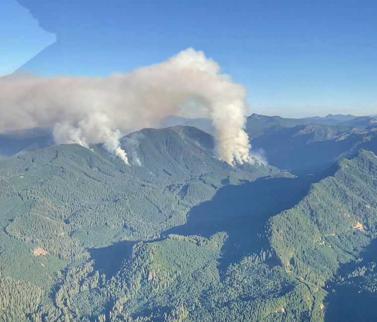
As for the Cedar Creek Fire, Forest Service officials said fire activity has increased, with continued hot and dry conditions, and most of the growth is now north of Waldo Lake, which had been a natural barrier to prevent the fire from moving east.
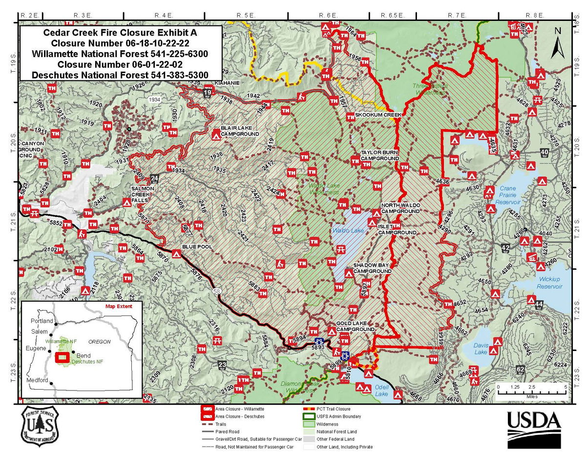
For the safety of the public, the Crescent and Bend-Fort Rock ranger districts on the Deschutes National Forest will temporarily close all Forest Service-managed roads, trailheads and trails from the forest boundary along the Cascade crest on the west, to roughly the Three Sisters Wilderness boundary on the east, down to Forest Road 4290 road system south to the Forest Road 4650 road system, and terminating at the Deschutes County line.
This closure will be in place until rescinded. officials said.
Trailhead closures within the closure area include:
- Irish and Taylor Lakes Trailhead
- Many Lakes Trailhead
- Charlton Lake Trailhead (confirm this is Deschutes/not Willamette)
- Moore Creek Trailhead
Trail closures within the closure area are as follows: Charlton (and associated trails), Clover Meadow, Corral Swamp, Elk Creek, Found Lake, Harralson, Irish and Taylor, Johnny Lake, Lemish Lake, Lily Lake, Maiden Peak (and associated trails), Many Lakes, Metolius-Windigo, Mink Lake, Moore Creek, Senoj Lake, Six Lakes, Snowshoe Lake, Teddy Lake, The Twins, Twins Peak, Upper Moore Creek, Winopee Lake.
This closure also specifically closes the Pacific Crest Trail from Highway 58 to the junction with the Six Lakes Trail near Elk Lake. Long-distance hikers can rejoin the PCT at Elk Lake via the Island Meadow Trail or the Horse Lake Trail. Visit the pcta.org for current information about closures.
The Cedar Creek Fire was caused by a lightning strike reported on August 1 and is burning on the Willamette National Forest. As of Monday morning, the fire had grown to 17,625 acres and was 12% contained.
The fire is currently being managed by Northwest Incident Management Team 6, a Type 2 Incident Management team under the command of Shawn Sheldon. For information on the Cedar Creek Fire, please visit https://inciweb.nwcg.gov/incident/8307/
Here's the closure map, followed by Monday's updates on the Cedar Creek, Double Creek, Crockets Knob and Rum Creek fires:
Cedar Creek Fire Daily Update 9/5/2022
Cedar Creek Fire Quick Facts
Size: 17,625 acres
Contained: 12%
Start Date: August 1, 2022
Location: 15 miles E of Oakridge, OR
Cause: Lightning
Total personnel: 823
Resources: 15 engines
16 crews
27 heavy equipment
8 helicopters
Community Meeting: A community meeting will be held Tuesday September 6th, at 6 PM at Greenwaters Park, 48362 Highway 58, Oakridge. For those unable to attend in person, the meeting will be streamed live on the Cedar Creek Fire Facebook page: https://www.facebook.com/CedarCreekFire2022
Current Situation: Fire activity remained moderate throughout most of the fire yesterday. The fire was burning in the Charlton Fire scar, which burned over 10,000 acres in 1996. Helicopters assisted in this area by dropping water to slow fire activity. Behavior has been characterized by creeping, smoldering, and single-tree torching.
Today’s Activities: Crews are making progress along the lower side of Black Creek by using sprinklers. They will start working on the upper side above Lillian Falls, and this work will take multiple days to complete. Firefighters continue utilizing the Winchester trail system as a check line to slow fire growth. In the northwest, the fire crews are enhancing contingency lines by chipping and masticating along roads with heavy equipment. To keep the fire north of Forest Service Road 2421, crews are utilizing small firing operations, in combination with aerial ignitions. Using Plastic Sphere Dispensers (PSDs) containing potassium permanganate, glycol is injected into the sphere, then expelled from the aircraft. This produces an exothermic reaction resulting in ignition of fuels on the ground.
Weather: Temperatures in the lower 80s. The inversion layer will break around noon. Weather is forecasted to change tonight into tomorrow with low relative humidity recoveries overnight and unstable air in the atmosphere, this has the potential to increase fire activity.
Closures: All trailheads and dispersed camping west and north of Waldo Lake are closed, this includes a section of Forest Service Road 19 (Aufderheide Scenic Byway). The Pacific Crest Trail is currently closed between Highway 58 north to the junction with Six Lakes Trail near Elk Lake. Long distance hikers can rejoin the PCT at Elk Lake via the Island Meadow Trail or the Horse Lake Trail. Visit the pcta.org for current information. The Deschutes National Forest implemented the Cedar Creek Fire Closure Order (Closure #06-01-22-02) on September 5. Closure Orders take precedent over evacuation levels meaning that if a location is within the closure area, it is closed to access regardless of current evacuation levels. Please visit Willamette National Forest and Deschutes National Forest for detailed closure orders. A Temporary Flight Restriction (TFR) is in place. Restrictions: Fire restrictions are in place on the Willamette National Forest and Deschutes National Forest with the exception of the Three Sisters, Mt. Jefferson, Mt. Washington, Waldo Lake, and Diamond Peak Wilderness areas. Smoke: Smoke Forecast Outlooks are available at https://outlooks.wildlandfiresmoke.net/outlook.
Fire Information: 8:00 AM – 8:00 PM | Phone: 541-201-2335 | Email: 2022.cedarcreek@firenet.gov
Online: https://inciweb.nwcg.gov/incident/8307/ | https://www.facebook.com/CedarCreekFire2022/ | https://www.facebook.com/willamettenf | https://twitter.com/willametteNF | YouTube: https://www.tinyurl.com/cedarcreekfireyoutube
Evacuations: There continues to be multiple evacuations in campgrounds and recreational areas near Waldo Lake and Waldo Lake Wilderness. Please check with Lane County Sheriff’s Office 541-682-4150 and Deschutes County Sheriff’s Office 541-693-6911 for updates and changes.
Double Creek and Eagle Cap Wilderness Fires
September 5, 2022
Daily Update – 8:00 AM
Highlights: Fire activity was significantly less on Sunday for both the Double Creek and Eagle Cap Wilderness Fires. Although temperatures were warm and relative humidity values were low, winds were much lighter than the previous day. Additional resources continue to arrive, including task forces form the Oregon Office of the State Fire Marshal (OSFM).
Double Creek Fire: 43,668 acres | 0% contained | 401 personnel assigned
The lightning-caused Double Creek Fire is a full suppression fire, and the protection of lives and property remain the primary objectives of this incident. New resources from OSFM arrived on Sunday to provide additional structure protection capacity. Task forces from OSFM initiated structure protection, cleared brush, and increased defensible space around homes along the Freezeout and Imnaha Roads. Firefighters secured a private inholding (Section 36) along Grizzly Ridge between Buck Point and Pumpkin Creek. Dozers cleared vegetation along the powerline in the Imnaha River corridor. All the known hunting parties were safely evacuated from the area. On Monday, firefighters will scout additional options on the northern and southern portions of the fire. Crews will mop up and patrol around structures along Freezeout Road and north along the Upper Imnaha Road. Firing operations will continue along the Upper Imnaha Road to secure the fire backing down drainages to the east. OSFM task forces will continue to assist with structure protection along the Imnaha Road and ensuring the protection of life and property in the community of Imnaha.
Weather: A weak cold front will move through the area in the early morning hours. Below normal fire weather conditions are expected Monday with moderate temperatures, higher relative humidity values, and light northwest winds behind the morning’s cold frontal passage. Tuesday and Wednesday’s weather is expected to result to above normal fire activity with increased winds from the southwest and temperatures in the 90s.
Smoke: Current air quality information for the local area is available on the PurpleAir website.
Evacuations: On Sunday, the Wallowa County Sheriff’s Office modified the evacuation levels for the Double Creek Fire. A Level 3 “Go Now” is in effect for the Town of Imnaha and south to Freezeout Road. The Upper Imnaha Road, Hat Point Road, and Wallowa Mountain Loop Road (Forest Service Road 39) are closed. A Level 2 “Get Set” is in effect for the area from the Town of Imnaha north to Fence Creek including the lands east toward Lightning Creek. A Level 1 “Be Ready” is in effect from Freezeout south to the Pallette Ranch and Imnaha River Woods.
Closures: There are currently trail and road closures in effect for the Double Creek Fire as well as the Eagle Cap Wilderness Fires. Closure Orders and Maps are available on the Wallowa Whitman National Forest Fire Incident Updates page.
Airspace: Several airspace restrictions have been issued for the Double Creek and Eagle Cap Wilderness Fires. Temporary Flight Restriction (TFR) 2/1532 is in place to provide a safe environment for firefighting aircraft operations on the Double Creek Fire. Notice to Air Missions (NOTAM) 08/234 and NOTAM 08/235 were issued to provide safe airspace for the Eagle Cap Wilderness Fires. Flight restrictions also apply to drones. Drones flying in areas of wildfire activity will cause tactical firefighting aircraft to be grounded.
Restrictions: Forest Order #06-16-00-22-04 covers Phase B Fire Restrictions for all National Forest System Lands within the Wallowa-Whitman National Forest, except for the area within a ¼ mile of the Snake River between Hells Canyon Dam, River Mile 247.5, downstream to the Oregon-Washington border at Snake River Mile 176.0, which is regulated by Forest Order #06-16-04-22-01.
Fire Information
Office Hours: 8:00 AM – 8:00 PM
Phone: 541-216-4579
Email: 2022.doublecreek@firenet.gov
InciWeb: https://inciweb.nwcg.gov/incident/8366/
Facebook: www.facebook.com/doublecreekfire2022
YouTube: https://tinyurl.com/Double-Creek-Fire
Crockets Knob Fire Update
NORTHWEST INCIDENT MANAGEMENT TEAM 12
Incident Commanders: Jeff Dimke and Bobby Shindelar
September 05, 2022
Weather: Dry conditions will continue today but temperatures will be cooler, with highs rising only into the 70s and lower 80s across the fire area. West to northwest winds will be light along ridgetops at less than 10 mph with gusts less than 15 mph.
Operations: Yesterday, firefighters made good progress along the western edge of the fire to hold and strengthen containment lines. Slightly lower temperatures and lower wind speeds gave crews an opportunity to create depth in the containment line and cool areas of more intense heat. Work along FSR 45 continues today with heavy equipment and crews moving north to improve the roadway for possible containment line. Several crews will be engaging along the northeastern corner and eastern flank today to construct direct line along the fire edge. Firefighters remain engaged along the northern edge where the fire continues to creep along in the available fuels. Many natural rocky areas on the north end are helping to reduce the rate of spread. Helicopters will continue to support firefighters on the eastern edge, cooling areas of heat and adding moisture to the fuels to slow fire growth. Containment continues to increase along the southern edge of the fire.
Closures and Evacuations: Grant County has issued a Level One evacuation advisory in the area of the fire. Level One means be ready and aware of fire conditions. You can view a map of the evacuation zone on the Grant County Emergency Management Facebook page.
An expanded closure is in effect on the Malheur and Umatilla National Forests today. For complete closure information, please go to: https://www.fs.usda.gov/detail/malheur/notices/...
Smoke may be visible to nearby communities and Forest visitors. Smoke and air quality impacts within the state can be monitored by visiting: http://oregonsmoke.blogspot.com
·A reduction in acreage is due to more accurate mapping.
Quick Facts:
SIZE: 4,265 Acres
·CONTAINMENT: 20%
CAUSE: Lightning
PERSONNEL: 612
LOCATION: 19 miles north of Prairie City
FIRE INFORMATION: 541-625-0892
FACEBOOK: https://www.facebook.com/CrocketsKnobFire
INCIWEB: https://inciweb.nwcg.gov/incident/8355/
TEMPORARY FLIGHT RESTRICTION
There is a Temporary Flight Restriction over the Crockets Knob Fire area. Wildfires are a No Drone Zone - if you fly, we can’t.
Rum Creek Fire Wildfire - Sept. 5 update
Size: 19,945 acres
Containment of perimeter: 34%
Total personnel: 1,914
Cause: Lightning
Date of Origin: Wednesday, August 17
Location: Galice
Firefighters prepare for another windy dry spell
MERLIN, Ore. – Tomorrow’s weather will provide a test for the fire lines. If the fire stays within the current footprint, fire managers can be more confident that it will not escape the fire lines in the future. Rum Creek Fire will be under a Haines 6 tomorrow, the highest level on the index, indicating the greatest potential for rapid fire growth. Also, the National Weather Service has issued a Fire Weather Watch for Tuesday afternoon and evening for the Rum Creek Fire area. The forecast calls for high temperatures, gusty winds and low relative humidity.
The Haines Index is a tool used to estimate the effect of atmospheric dryness and stability on fire growth potential. When the atmosphere is unstable, windy conditions allow mixing of air near the ground with air higher in the atmosphere. This mixing provides ample fresh air flow to a fire, allowing it to burn freely and potentially grow rapidly and develop a smoke plume. These conditions are more likely to allow a fire to run or spot past fire lines.
In advance of this weather change, firefighters are working aggressively to contain more of the fire. Sunday night, crews completed the last of the planned tactical firing operations on the west side, tying lines from Mount Peavine north to the Rogue River. The large areas of unburned fuels between this primary line and the natural fire edge in the Rum Creek drainage are being closely monitored. At this time, the fire is steadily burning through this area, reducing the chance of fire running across the primary line or spotting north across the Rogue River.
On the east side, tactical firing is expected to be completed today near McKnabe Creek. Firefighters continue to mop up around the fire perimeter and near any structures, reducing the chance for fire to cross the primary lines. This hard work is reflected in the increase in containment to 34%.
Office of State Fire Marshal resources continue to mop up remaining hot spots near structures, cutting hazard trees, and patrolling areas along Galice Road. Firefighters are also working on structure assessment and pre-planning to the north and southeast of the fire.
Fire personnel found three more burned structures, bringing the losses to two homes and four minor structures. These were destroyed during the fire’s rapid spread on August 26th and are in an area previously inaccessible to firefighters.
Evacuations: Existing evacuation orders and notifications remain in place. An interactive map showing evacuation levels according to address can be found at this Josephine County Fire Map. For the most current evacuation information and resources, go to Josephine County Incident Information (rvem.org).
Road control: Josephine County Sheriff’s Office has established traffic access points around the fire zone. Road blocks are located at Galice Road near Crow Road; Galice Store; Bear Camp Road at Peavine (top intersection); Lower Grave Creek Road at Angora Creek (Grays Ranch); Quartz Creek Road about 3 miles up (end of County maintenance); Dutch Henry Road near Kelsey Creek (42 44'56.2/123 40'35.4); and Hog Creek at Galice Road. The National Guard is staffing the roadblocks. Only residents (must show proof of residency) and permitted users will be allowed through.
River status: The Wild section of the Rogue River below Grave Creek will remain open unless fire conditions warrant closure. River status is determined on a day-to-day basis. Please call 541-471-6535 for more information regarding Rogue River permits. No new boating permits will be issued at this time.
