Red flag warning: Heat, winds pushing Oregon wildfires; smoke blows into C.O. from Cedar Creek Fire
(Update: Smoke blowing into region is from Cedar Creek Fire)
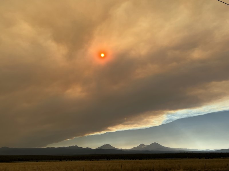
IMNAHA, Ore. (KTVZ) -- Critical fire weather means no break after a busy Labor Day weekend for thousands of firefighters battling large wildfires burning across Oregon. And that's also causing more growth of the Cedar Creek Fire, which sent smoke blowing into Central Oregon Tuesday afternoon.
Central Oregon fire officials assured there were no new large wildfires in the region, but said the higher winds as forecast and low relative humidity was increasing activity on the Cedar Creek Fire on the Willamette National Forest, amid red flag warnings of critical fire weather.
Meanwhile, air and ground crews tackled a new fire reported Monday evening a dozen miles southeast of Paulina Lake, holding it to an acre, Forest Service spokeswoman Kassidy Kern said.
Incident 857 was reported around 5:30 p.m. Monday by an air attack plane on a regular reconnaissance flight. It was 50% contained by Tuesday morning.
Two SEAT planes each dropped a retardant load on the fire while engine crews, a bulldozer and hand crew worked on the ground.
The cause of the fire is under investigation, Kern said.
Here are Tuesday's updates on the Cedar Creek, Double Creek/Eagle Cap Wilderness, Crockets Knob and Rum Creek fires:
Cedar Creek Fire
September 6, 2022
Cedar Creek Fire Quick Facts
Size: 18,143 acres
Contained: 12%
Start Date: August 1, 2022
Location: 15 miles E of Oakridge, OR
Cause: Lightning
Total personnel: 849
Resources: 19 engines
16 crews
33 heavy equipment
7 helicopters
Red Flag Warning: Today, a Red Flag Warning has been issued for hot, dry and unstable conditions and will likely remain through Wednesday. This combination of weather is expected to increase fire activity.
Community Meetings: Tuesday September 6th, 6:00PM, Greenwaters Park, 48362 Highway 58, Oakridge, Oregon and streamed live on the Cedar Creek Fire Facebook.
Thursday, September 8th, 7:00PM, focused on Deschutes County and Central Oregon, virtually on the Cedar Creek Fire Facebook Page.
Current Situation: Most of the fire growth occurred on the northeastern edge through the Charlton Fire burn scar. Predicted weather patterns are expected to increase fire behavior. Spotting distances will be .2 miles. Fuels, such as down logs, are extremely dry and will have a probability of ignition of 90%.
Today’s Activities: Firefighters will be working from the northeastern edge of Waldo Lake to improve the 514 road system up to the Taylor Burn Guard Station. This will establish an anchor point and primary line to build off of as the fire continues to move northeast. Crews on the northern portion of the fire will continue to improve Forest Road (FR) 2417 and the Winchester trail system towards the Taylor Burn Guard Station as the primary line and FR 19 as a contingency line. Portions of FR 19 have been closed from Kiahanie campground to Roaring River campground. Progress has been made from FR 2417 to Lower Quinn Lake. Firefighters will continue to scout for alternate lines in that area. On the southern edge, crew will continue to hold and improve FR 2421. A spike camp will be established on the southeastern edge of the fire to finish the line on Black Creek, which may take several days.
Weather: High temperatures are predicted to reach 98°F in lower elevations and 90°F in higher elevations. Wind speeds will reach 6-8 mph with gusts of up to 16 mph. Southeast winds will shift to southwest winds by the afternoon.
Closures: The Deschutes National Forest and Willamette National Forest have implemented closures for the Cedar Creek Fire. Please visit Williamette National Forest and Deschutes National Forest for detailed closure orders and a joint map. A Temporary Flight Restriction (TFR) is in place. Pacific Crest Trail hikers should visit pcta.org for current information.
Restrictions: Fire restrictions are in place on the Willamette National Forest and Deschutes National Forest with the exception of the Three Sisters, Mt. Jefferson, Mt. Washington, Waldo Lake, and Diamond Peak Wilderness areas.
Smoke: Smoke Forecast Outlooks are available at https://outlooks.wildlandfiresmoke.net/outlook.
Fire Information: 8:00 AM – 8:00 PM | Phone: 541-201-2335 | Email: 2022.cedarcreek@firenet.gov
Online: https://inciweb.nwcg.gov/incident/8307/ | https://www.facebook.com/CedarCreekFire2022/ | https://www.facebook.com/willamettenf | https://twitter.com/willametteNF |
YouTube: https://www.tinyurl.com/cedarcreekfireyoutube
Evacuations: There continues to be multiple evacuations in campgrounds and recreational areas near Waldo Lake and Waldo Lake Wilderness. Please check with Lane County Sheriff’s Office 541-682-4150 and Deschutes County Sheriff’s Office 541-693-6911 for updates and changes. Remember—Level 3 GO NOW, Level 2 Be Set, Level 1 Be Ready.
Double Creek and Eagle Cap Wilderness Fires
September 6, 2022
Daily Update – 8:00 AM
Highlights: There was an increase in fire activity on the southern end of the Double Creek Fire on Monday afternoon. Fire activity remained relatively light on the Nebo, Sturgill, and Goat Mountain 2 Fires. In anticipation of extreme fire weather, Oregon Governor Kate Brown night invoked the Conflagration Act for the Sturgill Fire on Monday. The Office of the State Fire Marshal (OSFM) ordered five additional task forces to support the fire.
Double Creek Fire: 53,539 acres | 0% contained | 580 personnel assigned
The lightning caused Double Creek Fire is a full suppression fire, and the protection of lives and property remain the primary objectives of this incident. Fire activity increased on the southern end of the Double Creek Fire near Freezeout Road Monday afternoon. Firefighters and task forces from the OSFM implemented structure protection and activated sprinklers installed around homes in the area. Tactical firefighting aircraft were not able to assist firefighters on the ground due to gusty northwest winds and an inversion over the area. On Tuesday, firefighters will evaluate yesterday’s fire activity along the Freezeout Road and OSFM resources will continue to protect structures in the area. OSFM task forces will also support firing operations along the Imnaha River. Fire crews will continue dozer and hand line construction above the powerline along the Imnaha River corridor and continue firing operations to keep up with fire spread to the north. On the north end of the Double Creek Fire, firefighters will scout for opportunities to construct a control line. OSFM resources will develop a structure protection plan for the Town of Imnaha.
Weather: The Fire Weather Watch has been elevated to a Red Flag Warning this evening from 6:00 p.m. through Wednesday at 8:00 p.m. Temperatures will be in the mid to upper-90s, maximum relative humidity values of 20 percent, and southwest winds at 10-15 mph on Tuesday. Critical fire weather conditions are expected Tuesday night through Wednesday evening with continued hot, dry, breezy conditions. There will be a slight chance for showers and thunderstorms Wednesday afternoon and evening; however, these will produce little rain along with erratic, gusty winds up to 45 mph.
Smoke: Current air quality information for the local area is available on the Oregon Department of Environmental Quality – Air Quality Monitoring website and PurpleAir website.
Evacuations: Level 1, Level 2, and Level 3 evacuations have been issued by the Wallowa County Sheriff’s Office. A Level 3 “Go Now” is in effect for the Town of Imnaha and south to Freezeout Road. A Level 2 “Get Set” is in effect for the area from the Town of Imnaha north to Fence Creek including the lands east toward Lightning Creek, and Lostine River Road from Fir Road south including all campgrounds. A Level 1 “Be Ready” is in effect from Freezeout south to the Pallette Ranch and Imnaha River Woods, and Lostine River Road from Highway 82 to Fir Road.
Closures: The Wallowa Whitman National Forest issued Temporary Area Closures for the Double Creek Fire, Nebo Fire, and Sturgill Fire (includes Goat Mountain 2 Fire) on Monday. Closure Orders and Maps are available on the Wallowa Whitman National Forest Fire Incident Updates page. The Wallowa County Sheriff’s Office has closed several roads associated with evacuations orders. The Upper Imnaha Road and Hat Point Road are closed. Wallowa Mountain Loop Road (FSR 39) is closed from Target Springs Junction to Ollokot Campground including the Canal Road (FSR 3920), and Lick Creek Rd (FSR 3925).
Airspace: Several airspace restrictions have been issued for the Double Creek, Nebo, Sturgill, and Goat Mountain 2 Fires. Temporary Flight Restriction (TFR) 2/1532 is in place to provide a safe environment for firefighting aircraft operations on the Double Creek Fire. Notice to Air Missions (NOTAM) 08/234 and NOTAM 08/235 were issued to provide safe airspace for the Nebo, Sturgill, and Goat Mountain 2 Fires. Flight restrictions also apply to drones. Drones flying in areas of wildfire activity will cause firefighting aircraft to be grounded.
Restrictions: Forest Order #06-16-00-22-04 covers Phase B Fire Restrictions for all National Forest System Lands within the Wallowa-Whitman National Forest, except for the area within a ¼ mile of the Snake River between Hells Canyon Dam, River Mile 247.5, downstream to the Oregon-Washington border at Snake River Mile 176.0, which is regulated by Forest Order #06-16-04-22-01.
Fire Information
Office Hours: 8:00 AM – 8:00 PM
Phone: 541-216-4579
Email: 2022.doublecreek@firenet.gov
- InciWeb: https://inciweb.nwcg.gov/incident/8366/
- Facebook: www.facebook.com/doublecreekfire2022
- YouTube: https://tinyurl.com/Double-Creek-Fire
---
Crockets Knob Fire Update
NORTHWEST INCIDENT MANAGEMENT TEAM 12
Incident Commanders: Jeff Dimke and Bobby Shindelar September 06, 2022
A community meeting will take place Wednesday night at 6 PM at the Prairie City Park and will also be live streamed on the fire’s Facebook page. Weather: Today is forecasted to have increased winds along with hotter and drier conditions. Temperatures will be in the upper 80’s this afternoon with wind gusts up to 25 mph, and relative humidity is expected to drop down to nearly 10% this afternoon. A red flag warning has been issued for tomorrow, September 7th, for the fire area.
Operations: Yesterday firefighters continued to secure containment lines along FSR 4550 and 45 Roads, and heavy equipment improved a potential contingency line along FSR 45 north toward the FSR 10. Spot fires west of FSR 45 from previous days were mopped up, which included finding and putting out remnant heat in areas already burned. Crews continued constructing direct handlines along the northeastern and eastern flanks of the fire. Helicopters supported firefighters with water bucket drops along the north and northeastern edges.
Today fire activity is expected to increase due to hot, dry and windy conditions. Firefighters will work to secure existing containment lines for the anticipated red flag conditions. Crews will engage directly with handlines along the north and northeastern flanks of the fire. Heavy equipment will continue improving the potential contingency line along FSR 45. Containment lines along the southern edge of the fire will continue to be monitored, mopped up, and secured.
Helicopters will continue to support firefighters on the northern and eastern edge, cooling areas of heat and adding moisture to the fuels to slow fire growth.
Closures and Evacuations: Grant County has issued a Level One evacuation advisory in the area of the fire. Level One means be ready and aware of fire conditions. You can view a map of the evacuation zone on the Grant County Emergency Management Facebook page. A closure is in effect on the Malheur and Umatilla National Forests today. For complete closure information, please go to: https://www.fs.usda.gov/detail/malheur/notices/?cid=STELPRD3845529
Smoke may be visible to nearby communities and Forest visitors. Smoke and air quality impacts within the state can be monitored by visiting: http://oregonsmoke.blogspot.com
Quick Facts:
SIZE: 4,305 Acres
CONTAINMENT: 25%
CAUSE: Lightning
PERSONNEL: 623
LOCATION: 19 miles north of Prairie City
FIRE INFORMATION: 541-625-0892
2022.crocketsknob@firenet.gov
FACEBOOK: https://www.facebook.com/CrocketsKnobFire
INCIWEB:https://inciweb.nwcg.gov/incident/8355/
TEMPORARY FLIGHT RESTRICTION
There is a Temporary Flight Restriction over the Crockets Knob Fire area. Wildfires are a No Drone Zone - if you fly, we can’t.
Rum Creek Fire Tuesday morning update
Quick Stats -
Acreage - 20,029
Resources Assigned - 1,840
Containment - 34%
Fire Information: 541-414-3278
Inciweb: https://inciweb.nwcg.gov/incident/8348/
Evacuations: https://tinyurl.com/JOCOEvacMap
Rum Creek Fire will be tested again
MERLIN, Ore. – The National Weather Service has issued a Red Flag Warning for Tuesday afternoon and evening for the Rum Creek Fire area. A Red Flag Warning means that critical fire weather conditions are either occurring now or will shortly. The forecast calls for high temperatures, gusty winds and low relative humidity. These conditions may cause a fire to flare up, and promote rapid spread of fire.
In advance of this weather change, firefighters have worked aggressively to cool and contain the fire. Operations Section Chief Mike Carlson describes the fire’s status as: “We’ve got a line around it and we want to keep it there.”
Crews completed the last of the planned tactical firing operations Sunday night, tying the west line from Mount Peavine to the Rogue River. Firefighters have found small slop-overs in this section, and are securing these. Unburned islands in the Rum Creek and Montgomery Creek drainages continue to burn actively. Members of the Crane Valley Hotshots will be working and camping near this remote area to monitor the fire and suppress flare-ups or spot fires as needed. This includes calling in aerial drops of water and retardant if needed.
Firefighters continue to mop up residual heat near all fire lines. The goal is to have a cold strip of ground adjacent to the fire line with minimal residual fuel to carry fire past containment lines. Firefighters are mopping up, adding depth along the edges, as time permits to reduce the chance of fire escaping.
Water drops from aircraft are cooling flare-ups and hot areas near the fire’s edges, especially in areas not accessible by engines and far from streams. Retardant was dropped outside the fire lines in some areas to reduce the chance of spot fires outside the planned perimeter. At times, air operations have been restricted by limited visibility due to smoke.
Office of State Fire Marshal resources continue to mop up remaining hot spots near structures, cut hazard trees, and patrol areas along Galice Road. They are available to assist with other fire duties as needed.
Monday, fire personnel found one burned commercial structure and one additional minor structure.
Today, Northern Rockies Incident Management Team 6 (NRIMT6) will be shadowing Northwest IMT 13 (NWIMT13), preparing for transfer of command of the Rum Creek Fire to ensure a smooth transition. NRIMT6 will assume management of the west side of the Rum Creek Fire tomorrow. Oregon Department of Forestry Team 1 (ODF1) will continue to manage the east side of the fire, operating under a unified command with NRIMT6.
Evacuations: Existing evacuation orders and notifications remain in place. An interactive map showing evacuation levels according to address can be found at //JosephineCounty.gov/FireMap. For the most current evacuation information and resources, go to Josephine County Incident Information (rvem.org).
Road control: Josephine County Sheriff’s Office has established traffic access points around the fire zone. Road blocks are located at Galice Road near Crow Road; Galice Store; Bear Camp Road at Peavine (top intersection); Lower Grave Creek Road at Angora Creek (Grays Ranch); Quartz Creek Road about 3 miles up (end of County maintenance); Dutch Henry Road near Kelsey Creek (42 44'56.2/123 40'35.4); and Hog Creek at Galice Road. The National Guard is staffing the roadblocks. Only residents (must show proof of residency) and permitted users will be allowed through.
River status: The Wild section of the Rogue River below Grave Creek will remain open unless fire conditions warrant closure. River status is determined on a day-to-day basis. Please call 541-471-6535 for more information regarding Rogue River permits. No new boating permits will be issued at this time.
