SW Oregon’s Flat Fire tops 27,000 acres amid burnout efforts, using drones and helicopter
(Update: Monday evening update)
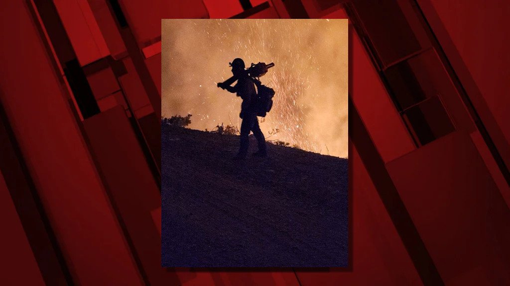
AGNESS, Ore. (KTVZ) -- Both drones and helicopters have been used to drop spherical ignition devices for burnout operations to remove unburned fuel within the perimeter of the 27,573-acre Flat Fire, now 14% contained, officials said Tuesday.
Here's Tuesday morning's update - check the latest at https://www.facebook.com/flatfireoregon2023:
Size (acres): 27,573
Point of origin: 2 miles southeast of Agness, OR
Containment: 14%
Cause: Human caused, Under Investigation
Total personnel: 1,547
Resources: 52 engines l 35 crews l 2 bulldozers l 25 water tenders l 4 masticators l
9 helicopters
Current Situation: Yesterday, In the southwest corner of the fire area, firefighters used Unstaffed Aerial Systems (UAS/drones) aerial ignitions to increase the burnout to about 200 feet interior from the fire line. Helicopters also used a Plastic Spherical Dispenser (PSD) for aerial firing operations further interior, bringing the main fire southwest towards the fire line. This strategy moves the main fire toward the prepared fire line under more favorable and controlled conditions. Fuels consumption is varied due to the existing vegetation mosaic on the landscape (brush, grass and timber). A burn-out operation along the dozer line heading east from Game Lake was completed with about 150 feet of depth interior of the line to the main unburned area.
Structure protection resources continue scouting for and identifying additional homes and buildings and are collecting data to aid firefighters in protecting structures if there is a future need. The alternate control line on Forest Service Road (FSR) 3313, 1503, and 3680 is planned for completion on Tuesday.
A community meeting was held in Brookings-Harbor last night and was live streamed on Facebook. A recording can be viewed at https://fb.watch/m8b1R2JtRk/ .
Today’s activities: Firefighters will use aerial resources to achieve additional fireline depth between the western and eastern portions of FSR 3680 in the southwestern corner of the fire. Aerial interior burning will also start in the Game Lake area. Fuels removal will begin today from vegetation cut in preparing fireline along the western containment lines. The northern containment line, from Wildhorse Lookout east to FSR 3577, is being actively mopped up and patrolled. The northeastern corner of the fire, using FSR 2308 and 150, has been prepared for firing operations if the need arises due to changes in weather conditions and/or fire activity.
With fire traffic on Bear Camp Road, all motorists on Bear Camp Road are asked to slow down, use headlights and proceed with caution.
Resources no longer needed for remaining suppressions efforts are being released to return home, get rest and be ready for future assignments as we head into the remaining fire season.
Evacuations: As of yesterday, July 31, all remaining evacuation levels were reduced to Level 1 “Get Ready” evacuation status for all areas in the vicinity of the Flat Fire.
The Curry County Sheriff’s Office will continue to coordinate with the Fire Incident Management Team and will notify all residents affected by the fire of any reasons to change evacuation levels.
Curry County is using Everbridge to send evacuation notices. You can sign up for notifications here: https://www.co.curry.or.us/departments/emergency_management/index.php.
Weather: Today’s forecast calls for slightly warmer temperatures (up 3-5 degrees) and lower relative humidity (down 3-5%). Today has the potential to be the warmest day on the Flat Fire so far.
Smoke: The Smoke Outlook is available at: https://outlooks.airfire.org/outlook/en/b74901f7
Closures: The Rogue River-Siskiyou National Forest has issued a closure order for the fire area including trails, roads and a portion of the Illinois River. Oak Flat Campground, Game Lake Campground, Wild Horse Campground and Snow Camp Lookout Recreation Rentals are all closed as part of the area closure. The Chetco River Road (FSR 1376) and Chetco/Pistol River Road (FSR 1407) are now closed. The updated closure allows for public access to the Big Rock swimming hole on the Illinois River. More information can be found here: https://tinyurl.com/bdzbae69.
Restrictions: Fire Restrictions are in place, to learn more visit: fs.usda.gov/rogue-siskiyou
Local fuel conditions are variable with fuels dry in some areas but still green vegetation in others. Warming and drying weather conditions continue resulting in higher fire danger.
Please follow all fire restrictions and only use properly functioning spark arresters and stay on designated trails and roads. Do not park, idle or drive on dry, flammable vegetation. Your vehicle could start a wildfire.
