McKenzie Pass Highway reopens west of Sisters as Lookout Fire evacuation levels are reduced
(Update: Hwy. 242 reopens; Tuesday fire updates)
SISTERS, Ore. (KTVZ) -- ODOT reopened Oregon Highway 242, the McKenzie Highway, Tuesday morning following reductions in Lookout Fire evacuation levels. A 15-mile stretch of the highway was closed nearly a month ago, on August 18, due to activity from the Lookout Fire, which has burned over 24,000 acres but is now 50% contained.
"We want to remind you that the Lookout Fire remains active," ODOT said in its announcement. "Watch for fire vehicles in the area and prepare for the possibility of closures if fire conditions change."
Drivers on this winding road also need to be on the lookout for cyclists and pedestrians, as this is a popular scenic route for many different road users. Vehicles longer than 35 feet are prohibited from using the highway due to its sharp, narrow curves.
The highway usually closes for the season the Thursday after Veterans Day, but that date can change with the weather. Tripcheck.com is always up to date with road closure information.
Here are Tuesday's updates on the Lookout, Bedrock and two other Willamette blazes, and on the Flat Fire and nearby Anvil Fire in SW Oregon.
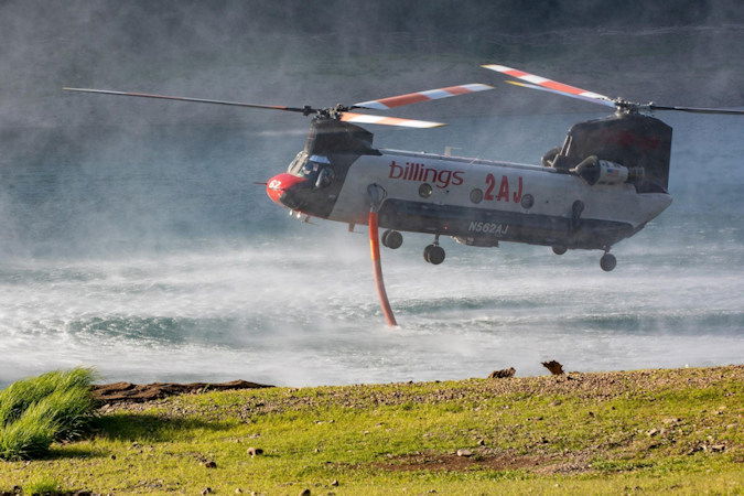
Lookout Fire, Bedrock Fire, 2023 Horse Creek Fire
News - 09/12/2023
Lookout/Horse Creek/Pothole/Bedrock Fires
September 12, 2023 - Morning Update
Lookout: Total Personnel: 795 | Size: 24,548 acres l Start Date: August 5, 2023 l Cause: Lightning l Containment: 50%
Resources: 35 engines l 14 crews l 4 bulldozers l 26 water tenders l 6 masticators l 5 helicopters l 2 Skidders
Suppression work on the Lookout fire will strengthen containment and contingency lines in all areas of the fires. Firefighters noted heat and smoke along Carpenter Ridge. To moderate spread, helicopters once again dropped retardant and water on Carpenter Ridge. Crews performed regular and consistent patrol and monitoring on the east and south divisions. At the White Pine contingency line east across Hwy. 126, night crews hauled 26 loads of wood material from the region to a processing site.
Horse Creek: Total Personnel: 86 |Size: 763 acres l Start Date: August 24, 2023 l Cause: Lightning l Containment: 90%
Resources: 4 engines l 3 crews l 2 bulldozers l 2 water tenders l 1 masticator l 2 Excavators | 2 Skidders
Horse Creek containment remains at 90 percent. Crews continue to patrol and monitor along the fire’s edge. In the southeast corner, firefighters continue to face difficult access due to steep terrain.
Pothole: Total Personnel: 29 |Size: 109 acres l Start Date: August 25, 2023 l Cause: Lightning l Containment: 90% Resources: 1 engine l 1 water tender |1 Masticator | 1 Skidder
Pothole suppression repair crews pushed containment to 90 percent. Acreage remains unchanged. Patrol and monitoring will continue. Crews will continue to hold and secure the southern flank.
Bedrock: Total Personnel: 193 | Size: 31,590 acres l Start Date: July 22, 2023 l Cause: under investigation l Containment: 90% Resources: 11 engines l 4 crews l 13 water tenders l 5 masticators l 4 helicopters l 1 Skidder
Bedrock suppression repair crews are working to expand containment past 90 percent. Acreage remains unchanged. Suppression crews were integrated with repair crews to increase repair work capacity.
All Fires: At this stage, suppression repair plays a key role in all four fires. But what exactly do we mean by suppression repair? When wildland fires erupt firefighters respond quickly: bulldozers push-up gravel berms and reshape roads, hand crews build huge swaths of containment line, engine crews remove soil during mop-up, helicopters drop retardant, sawyers remove brush, and trees of all sizes. The effects across the forest can be long-lasting. If left unrepaired severe erosion, vegetation loss and harm to other forest resources may occur.
The suppression repair objective is to repair damage caused by these fire suppression activities, and to return the affected area to pre-fire conditions as closely as possible. Their work is specifically designed to minimize surface and gully erosion, minimize sediment delivery to stream channels, restore conditions to pre-fire drainage patterns, minimize loss of soil productivity due to potential erosion in cleared areas, and minimize the introduction or spread of noxious weed infestations. It’s hoped that the use of suppression repair will result in a healthier forest following the effects of wildland fire.
Weather
Cloud cover increased overnight allowing fog to form in the morning in the valleys and drainages. Today will be the coolest day of the week with valley highs in the mid-70s. Expect an increase in winds toward afternoon as a system approaches the area on Wednesday. A more pronounced period of warm, dry, and unstable conditions will return on Thursday into the end of the weekend.
Evacuation Update
For the Lookout and Horse Creek fires, the Lane and Linn County Sheriff Offices announced an Evacuation Alert change.
- All LEVEL 1 (BE READY) and LEVEL 2 (BE SET) Evacuation Alert Levels are lifted completely.
- All LEVEL 3 (GO NOW) Evacuation Alerts are downgraded to a LEVEL 1 (BE READY) preparedness level.
See their websites for more information.
Lane County Evacuations: https://www.lanecountyor.gov/cms/one.aspx?pageId=19729054
Linn County Evacuations: https://www.linnsheriff.org/
Road Closures:
Highway 242, McKenzie Highway, has reopened for travel. Please monitor Trip Check for any updates at: https://tripcheck.com/
Forest Closures: The closure order for the Lookout Fire was reduced Sept. 7th due to successful firefighting efforts on the Horse Creek and Pothole Fires. Castle Rock Trailhead, Kings Castle Trailhead, McKenzie Bridge Boat Launch and other recreation sites and trailheads are open. Updated closures can be found at: https://www.fs.usda.gov/alerts/willamette/alerts-notices/?aid=61574
Restrictions: Fire Restrictions are in place on the Willamette National Forest. Visit the Willamette National Forest Website to view current forest closures. Temporary Flight Restrictions remain in place over the Bedrock and Lookout fire areas.
Smoke Outlook: https://outlooks.wildlandfiresmoke.net/outlook/4c92bc1a The Fire and Smoke Map (fire.airnow.gov) is another source for air quality information.
--
Flat Fire, Anvil Fire
News - 09/12/2023
Anvil Fire Activity
Size: 587 acres Start Date: August 25, 2023 Point of origin: 8 miles east of Port Orford, OR
Containment: 0% Total personnel: 310
Resources: 10 crews, 3 helicopters, 4 engines, 5 water tenders, 4 pieces of heavy equipment
Helicopters were unable to fly yesterday due to the weather. However, clouds and drizzle over the fire area moderated fire behavior. Wildland Fire Module crew members continue to provide fuels and weather data to the Fire Behavior Analysts and Incident Meteorologists for modeling and analysis. Tomorrow, machine operators will begin tracking two mini-excavators to the China Peak area to work alongside the dozer, constructing machine line and opening and connecting roads to use as control lines if needed. Masticator work continues alongside crews on Grassy Knob Road to the forest boundary, clearing vegetation and widening the road to create a control line. Interagency Hotshot Crews and the dozer operator progressed on the Grassy Knob Road to Elk River Road fireline. Hand crews are working north from the fish hatchery to figure out a place to tie in with the dozer line. Firefighters will continue to set up hoses and sprinkler systems at residences along Elk River Road. The fire remains north of Red Cedar Creek, east of Anvil Creek, and south of a Dry Creek tributary.
Flat Fire Activity
Size: 34,242 acres Start Date: July 15, 2023 Point of origin: 2 miles southeast of Agness, OR
Containment: 75% Total personnel: 281
Resources: 5 crews, 3 helicopters, 11 engines, 7 water tenders, 6 pieces of heavy equipment
Heavy equipment operators and hand crews continue with suppression repair work on the Flat Fire. This work includes pulling in dozer line berms, seeding, mulching, installing water bars, and chipping branches and small trees. Firefighters are watching and addressing, as needed, interior pockets of fuel that continue to burn out to ensure they are not a threat to firelines. On the eastern, uncontained side, crews remain vigilant, watching fire behavior and taking appropriate actions to cool hot spots and keep fire inside the current perimeter. Initial attack resources remain available for new fire starts.
Weather: Today, conditions will begin to warm up and dry out. A northeast wind shift will start to occur in the afternoon. On Wednesday and Thursday, near-critical fire weather conditions are forecast, with increased winds predicted.
Smoke: Visit https://fire.airnow.gov/ for current smoke and air quality updates.
Closures: The Rogue River-Siskiyou National Forest (RRSNF) has issued an updated closure order for the Anvil Fire (06-10-28-23-63). Visit https://bit.ly/RRSNFAlerts for Flat and Anvil Fire closure information. U.S. Highway 199 re-opened Monday morning after a rockslide caused a closure Sunday. There is still a pilot car system operating, expect 20-40 minute delays. Local law enforcement cautions against any non-essential traffic along this route. Navigation apps and mapping programs have been routing travelers into active fire areas. Check www.tripcheck.com in Oregon and www.quickmap.dot.ca.go in California for current closures and detours. Do not use forest roads for alternate routes.
Evacuations: Level 1 “Get Ready” evacuation status is in place for areas near the Flat Fire. Level 2 “Get Set“ evacuation status is in place along the Elk River from about milepost four to the USFS Butler Bar Campground near the Anvil Fire. Sign up for Curry Co. emergency alerts at https://bit.ly/CurryCoEM.
Restrictions: The RRSNF decreased fire danger from Extreme to High and the Industrial Fire Precaution Level from Level 3 to Level 2, effective Sept. 5, 2023. Public Use Restrictions (PUR) remain at Stage 3 across the forest and on the Wild Section of the Rogue National Wild and Scenic River. Visit https://bit.ly/RRSNFAlerts for more information. There is a Temporary Flight Restriction (TFR) over the fire areas. Please do not fly unmanned aircraft (drones) in the fire vicinity. If you fly, we can't.
