DCSO drops all Petes Lake Fire evacuation levels amid rain, cooldown; C. Oregon’s smoke from the south also relents
BEND, Ore. (KTVZ) -- Autumn rainfall and cooler temperatures have reduced fire behavior, prompting the Deschutes County Sheriff's Office on Monday to drop all evacuation levels tied to the Petes Lake Fire west of Elk Lake, though forest closures remain in effect.
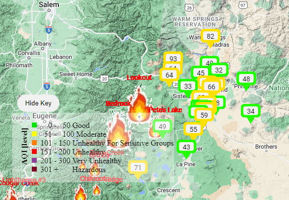
The change in weather Monday also improved Central Oregon's air quality from the "unhealthy" weekend caused by smoke moving in from wildfires to the south, in southwest Oregon and Northern California.
Indeed, by Monday morning, much of the High Desert was in the "moderate" or even "good" category, in terms of air quality, according to the E::Space AQI map on our weather page.
Here's Monday's update from DCSO Sergeant Jason Wall:
Due to cooler weather, recent precipitation and decreased fire activity, the Deschutes County Sheriff's Office is dropping all evacuation levels around the Petes Lake Fire.
Much of the area west of the Cascade Lakes Highway south of Mirror Lake Trail and north of the Six Lakes Trail is still under a Forest Closure issued by the Deschutes and Willamette National Forests. For information regarding forest closures, please visit: https://www.fs.usda.gov/alerts/deschutes/alerts-notices
As conditions change, evacuation levels may change. Please follow on social media and check www.deschutes.org/emergency for up-to-date evacuation notices.
Here's Monday's updates on the Petes Lake and other Willamette National Forest fires, as well as the Flat, Anvil and Smith Rock Complex fires to our south:
Lookout, Bedrock, Petes Lake, Horse Creek, and Pothole Fires
Monday, September 25, 2023 - Morning Update
Current Status:
Lookout Fire: Size: 25,751 acres l Start Date: August 5 l Cause: Lightning l Containment: 50%
Bedrock Fire: Size: 31,590 acres l Start Date: July 22 l Cause: under investigation l Containment: 98%
Petes Lake Fire: Size: 3,254 acres l Start Date: August 25 l Cause: Lightning l Completion: 50%
Horse Creek Fire: Size: 763 acres l Start Date: August 24 l Cause: Lightning l Containment: 100%
Pothole Fire: Size: 109 acres l Start Date: August 25 l Cause: Lightning l Containment: 100%
Total Personnel: 712
Total Assigned Resources: 21 engines l 18 crews l 4 dozers l 19 water tenders l 4 masticators l 3 helicopters
Suppression: With the cool weather and wetting rain further decreasing fire behavior to creeping and smoldering even extinguishing some areas of remaining heat within the fires’ perimeters, most firefighting resources are focused on suppression repair. However, crews working on the Petes Lake Fire expect to finalize mastication efforts to reduce fuels between the fire and Forest Service Road 4628 on Monday.
Suppression Repair: Crews continue to work on chipping small diameter trees and other vegetation cut during the fire suppression efforts. Larger trees are being hauled offsite to remove the fuel for potential future fires. As the rainfall amounts and wind speeds increase, the environment that firefighters are working in becomes more dangerous. Saturated soils and wind gusts can further weaken trees and put firefighters at increased risk for fatal injuries. However, they continue to make risk-informed decisions in the field to complete the necessary suppression repair work while remaining safe.
On the Bedrock Fire, 6.6 miles of handline created by firefighters to limit fire spread have been repaired. Another one mile of handline repair is needed on the Bedrock Fire. In comparison, only two miles of the nearly nine miles of handline constructed on the Lookout Fire have been repaired thus far. About half of the handline miles constructed on the Horse Creek Fire have been repaired. Across all five fires, nine miles of handline have been repaired. Efforts are wrapping up throughout the Horse Creek Fire, with 0.6 miles of handline repair to complete in the northern end of the fire footprint. Suppression repair efforts on the Pothole Fire should be completed today.
Additional suppression repair work includes removing supplies firefighters used in the suppression efforts on each of the fires. To date, firefighters have backhauled more than four semi-truck loads of supplies used in the field – including 30 miles of hose that were deployed in the event it was needed. When returned, these supplies are refurbished and made available for another incident across the region or country.
Weather: Cloudy skies and widespread rain persisted throughout last night and into this morning as a cold front moved into the region. Heavy rain and scattered showers are expected throughout the day with high temperatures in 50s. Winds along ridgetops near the Lookout Fire and Petes Lake Fire will be from the south-southwest, with gusts up to 25-30 miles per hour. More light to moderate rainfall is expected throughout the week.
Linn County Evacuations: Visit the Linn County Wildfire map for current evacuation information.
Lane County Evacuations: Visit the Lane County Lookout Fire Evacuation Areas map for current evacuation information.
Deschutes County Evacuations: Visit the Deschutes County Emergency Information map for current evacuations information.
Forest Closures: Emergency closure orders remain in place for the Willamette National Forest and the Deschutes National Forest. For information on Oregon hunting regulations and these forest closures, contact Oregon Department of Fish and Wildlife at (503) 947-6000.
Restrictions: Fire Restrictions are in place on the Willamette National Forest and Deschutes National Forest. Temporary Flight Restrictions remain in place over the Bedrock and Lookout Fire areas.
Smoke Outlook: A smoke outlook for West-Central Oregon includes the Lookout, Bedrock, Petes Lake, Horse Creek, and Pothole Fires. Another source for air quality information is the Fire and Smoke map from airnow.gov.
Fire Information:
Email: 2023.lookout@firenet.gov
Phone: 541-215-6735 (8 a.m. - 8 p.m.)
Facebook:
InciWeb:
- Lookout Fire
- Horse Creek Fire (includes Pothole Fire)
- Bedrock Fire
- Petes Lake Fire
--
Anvil Fire
Size: 21,842 acres | Start Date: August 25, 2023 | Location: 8 miles east of Port Orford, OR | Containment: 17% | Total personnel: 1,308 | Resources: 35 crews, 10 helicopters, 48 engines
Crews were able to hold the northern fire perimeter even with sustained 20 mph winds and gusts of 45 mph. The northeast corner of the fire area remained the most active, yet high humidity and wetting rains prevented significant fire growth. Continued hard work by firefighters and the changing weather accounts for an increase of overall fire containment.
Fire engines and crews patrolled the Sixes River Road corridor ensuring primary and contingency plans were in place throughout the day’s high winds in the event fire activity increased suddenly. Additional resources were present on the western fire perimeter near the Hatchery and structures. Crews actively patrolled the Elk River Road corridor ensuring no burning materials rolled over primary containment lines. Coos Forest Protective Association (CFPA) heavy equipment and ground crews strengthened containment lines near the Sunshine Bar area to limit any additional fire spread.
Flights by aviation resources were limited by the adverse weather conditions across the fire area. An unmanned aircraft system (UAS) was able to make an early morning flight, providing firefighters with perimeter fire data and showing areas with highest concentrations of heat from the fire. If conditions permit, the UAS will continue to gather information today, which may include the status of roads. With the advent of heavy wetting rains and potential for runoff and floods in the fire area, crews plan to remain in fire camp longer this morning. Supervisors will assess the safety of roads and trails this morning prior to beginning work, especially near steep slopes where debris flows are possible.
Evacuations: Curry County Sheriff’s Office has identified four evacuation zones around the Anvil Fire. At this time, Zones 1 and 4 remain in Level 3 “Go” evacuation status and Zones 2 and 3 are in Level 2 “Get Set” status. The Sheriff and fire managers are constantly evaluating the evacuation status and will lift them once there is certainty that they would not need to be reinstated. View the interactive evacuation map at https://bit.ly/45UIh2E. Sign up for Curry Co. emergency alerts at https://bit.ly/CurryCoEM. The Red Cross shelter in Port Orford is in standby to support any evacuees.
Area and Road Closures: For the safety of firefighters and the public, the Rogue River-Siskiyou National Forest (RRSNF) and Bay District Bureau of Land Management have issued closure orders for the Anvil Fire area. Find maps and closure information at https://inciweb.wildfire.gov/incident-closures/orrsf-anvil-fire.
Flat Fire
Size: 34,242 acres | Start Date: July 15, 2023 | Location: 2 miles southeast of Agness, OR | Containment: 75% | Total personnel: 11 | Resources: 3 engines
The RRSNF closure on the Flat Fire remains in effect, https://inciweb.wildfire.gov/incident-closures/xx1002-flat-fire.
General Information
Weather: Showers were observed across the Flat and Anvil Fire perimeters yesterday and overnight. The majority of wetting rain began early this morning, and steady but lighter precipitation is expected to continue until around noon. Projected rain accumulations through Tuesday range from 2 to 4 inches, which could potentially trigger dangerous debris flows in the fire areas. The National Weather Service has issued a Flood Watch effective from 2 AM this morning through 11 PM this evening.
Smoke: Visit https://bit.ly/SWORsmoke for current smoke and air quality updates. Smoke and the marine cloud layer are mingling and settling in the lower elevations overnight causing limited visibility along highways. Please drive slowly and with headlights on through any fire area. Caltrans issued a schedule of road closures and lane restrictions on US-199 northeast from Crescent City. Local law enforcement cautions against any non-essential traffic along this route. For specific information on road access, please see the Caltrans QuickMap site, https://quickmap.dot.ca.gov/ and Oregon Department of Transportation site, https://www.tripcheck.com/. Do not use forest roads for alternate routes.
--
Smith River Complex
News - Sept. 25, 2023
Size: 94,508 acres (12,460 ac. in Oregon); Location: Grants Pass, OR; Cause: Lightning
Containment: 85%; Start date: August 15, 2023; Total personnel: 1,199
Resources: 26 crews 6 helicopters 29 engines 8 dozers 17 water tenders 4 masticators 1 Skid Steer
Yesterday: Fire suppression repair and backhauling operations continued on the north end of the fire. Construction progressed on the secondary control line that is situated northwest of the fire along the FS 1106 road. To the southwest of the fire, the other secondary line is now in the final stages of clean-up.
Today’s Activities: Fire managers are monitoring the progress of the weather system that is predicted to be in full force today and lasting into Tuesday. Heavy rains are predicted; flood warnings and a wind advisory will also be in effect. This impending event has implications for the safety of firefighters, contractors, and support staff. Operational contingencies are in place that include directing fire personnel to stand down for safety for up to 24 hours until weather conditions improve. Firefighters remain prepared to respond to natural resource related hazards, such as downed trees, rock falls and mudslides.
Evacuations: The Josephine County Sheriff has set the evacuation status to Level 1-BE READY. Levels will be reevaluated on a recurring basis. This includes the area west of US-199 in Josephine County, including the community of O’Brien and to the Oregon-California border. Monitor the Rogue Valley Emergency Management site and also sign up for evacuation alerts, updates and an interactive Fire First Response Map with evacuation areas here: https://rvem.org/.
Smoke: Southerly to southwest winds will usher smoke northward and inland into Sunday. Smoke from active fires in northern California will contribute to reduced air quality before arrival of rains. The most impacted communities will be along and east of the US-101 corridor of Curry County, inland to Grants Pass and the US-42 corridor. Early smoke in drainages should begin to dissipate by early afternoon. Check current conditions at: https://bit.ly/SWORsmoke
Area Closures: A closure is in place on the Rogue River-Siskiyou National Forest for Forest Road 1106 (South Elk Mountain Road), Forest Road 1205 (Lower Wheeler Road), and Forest Road 1983 (Mt. Emily Road) until October 31, 2023 or until rescinded. The closure allows for safe operations related to the Smith River Complex North. Closures on BLM land are in place as well. Visit bit.ly/RRSNFAlerts or https://www.blm.gov/orwafire for additional information.
Road Closures and Delays: Caltrans in Del Norte County issued a schedule of road closures and lane restrictions on US-199. Weekdays will have a combination of road closure and lane restrictions. Over the weekend, the road will remain open, but with lane restrictions and pilot cars. Expect delays. For specific information on road access, please see the Caltrans QuickMap site https://quickmap.dot.ca.gov/ and Oregon Department of Transportation’s https://www.tripcheck.com/. Local law enforcement cautions against any non-essential traffic along this route. Navigation apps and mapping programs have been routing travelers into active fire areas. Do not use forest roads as alternate routes.
Restrictions: Please respect the temporary flight restriction (TFR) established for the Smith River Complex. Keep drones away from firefighting operations and the TFR. If you fly, we can’t. Don’t be the reason a firefighting air mission has to divert! For more information on the TFR, visit https://tfr.faa.gov/.
