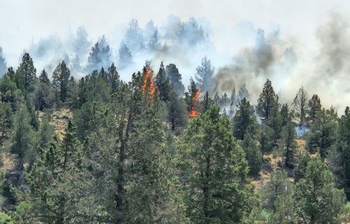
Lone Rock Fire grows to 116,000 acres in hot, unstable conditions, but 40% contained; many homes saved, some lost
(Update: Sunday morning report)
CONDON, Ore. (KTVZ) – The more than week-old Lone Rock Lone Rock Fire 10 miles southeast of Condon continues to grow quickly, to over 116,000 acres by Sunday, while containment by over 800 firefighters has risen to 40%, but authorities say while "a lot" of homes have been saved, some have been lost to the large blaze.
Sunday morning update:
Location: Lonerock, Oregon to west of Hwy 207| Size: 116,563 acres | Containment: 40% | Cause: Under Investigation | Start Date: July 13, 2024 | Total Personnel: 819
InciWeb: https://inciweb.wildfire.gov/incident-information/orprd-lone-rock-fire
Fire Information Line: 541-208-4369 | Email: 2024.0404rvlonerock@firenet.gov
Condon, Oregon — The Lone Rock Fire is being managed under a full suppression strategy by the unified command of the Northwest (NW) Team 2 and Oregon State Fire Marshal (OSFM) Red Team.
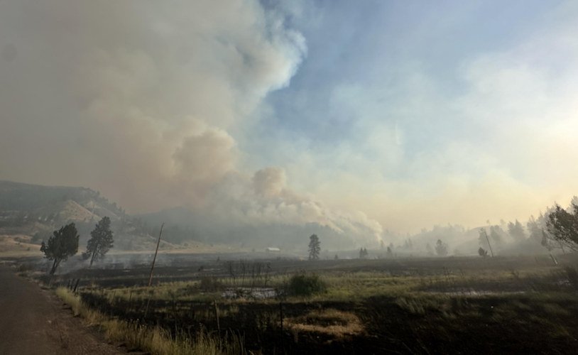
Yesterday’s Activities: On Saturday, fire behavior remained active in the afternoon and through the night due to the hot, dry, and unstable conditions. However, an increase in smoky conditions moderated the potential for more extreme conditions. Both wildland firefighters and structural taskforces were engaged with a dynamic firefight all day and into the evening. Winds from the northeast influenced the fire’s growth to the southwest. Firefighters continued to remain focused protecting life and property in coordination with county sheriff’s office upon execution of changes to evacuation levels; protection of structures and dwellings in the path of the active fire front; and continuing to build containment lines along the flanks of the fire.
Approximately 130 people attended last night’s community meeting in Fossil. An additional 6,300 people have viewed the meeting online since the live broadcast. Incident Commander Ian Yocum shared with the attendees that “our firefighters have saved a lot of homes through this firefight, and we know that homes have been lost. The reality is, it will be a while until we can get into these places and do a complete damage assessment.” A recording of the community meeting is available on the Lone Rock Fire Facebook page.
Today’s Activities: Today marks the second consecutive day of critical fire behavior, with hotter and drier conditions than yesterday. A forecasted cold front passage tonight could also create a chance of thunderstorm development, resulting in outflow winds having the potential to cause gusts that may drive the fire in any direction. Despite the adverse conditions, firefighters continue to make progress by utilizing fundamental firefighting principles: anchor, flank, and pinch. Firefighters are utilizing the fire’s easternmost point, in the area north of Morrow County OHV Park as an anchor point. Reinforcing this area with containment line is a priority to continue flanking south and making progress in controlling the fire.
Despite the active fire behavior in the Alder Creek area, the fire has not crossed Alder Creek at this time. Another priority area is Kahler Basin Road, where the fire is holding. Firefighters will focus on keeping the fire contained at Alder Creek and Kahler Basin Road. Recognizing that direct firefighting efforts have proven more effective, firefighters will continue to work directly on the fire’s edge whenever possible. With the continued critical fire weather conditions and extreme fire behavior expected again today, firefighters will maintain a keen sense of situational awareness to ensure firefighters can temporarily disengage for their safety.
OSFM task forces will maintain a large presence in ,and around, the town of Spray. The tactical objective of the structural teams remains steering the fire around the town. Crews will engage and perform structure protection and fire suppression in a safe and tactical manner.
During the evening and into tomorrow, a large contingent of engines made up of OSFM crews and crews from our wildland partners will be engaged in structure triage, preparations, and protection along the John Day River and HWY 19. Tactical decisions based on safety and probability of success will be employed during this highly dynamic operational period. Two OSFM taskforces are also working in the area around the Boneyard Fire north of Monument. They are providing point protection around structures and performing surface preparations where appropriate. OSFM’s top priority remains the protection of people and their property,
Evacuations:
- Level-3 Evacuations – GO NOW! Level-3 Evacuate immediately for the following areas:
- Gilliam County: residences South of Lonerock. Visit Gilliam County Sheriff’s Office Facebook page.
- Wheeler County: HWY 19 at Rowe Creek Road, south on Rowe Creek Road to Twickenham Bridge, to HWY 19 at Girds Creek, east to the county line, north of the county line to Morrow County line, west on the northern county line, south through the Kinzua area, south back to Rowe Creek Road. Visit Wheeler County Sheriff's Office Facebook page.
- Morrow County: from the West County Line along Buttermilk Canyon to HWY 207, Mile Post 10 south of Hardman to the south Morrow County line. The Red Cross will be setting up a temporary shelter at the Heppner Elementary School. For more information on evacuations, visit Morrow County Sheriff’s Office Facebook page.
- Level-2 Emergency Alert – GET SET! Level-2 Be set to evacuate at a moment’s notice for the following areas:
- Gilliam County: residences north of Lonerock. Visit Gilliam County Sheriff’s Office Facebook page.
- Wheeler County:
- Level 1: Be Ready – Prepare to Evacuate. Level 1 Be ready to evacuate in the following areas:
- Wheeler County: the area east of Richmond/Tamarack Creek and west of Misery Mountain/Johnson Creek 5-7 mi south of HWY 207
Shelters:
- An evacuation center has been set up at the Wheeler High School (600 E B Street, Fossil, Ore.). A large animal shelter is available at the County Fairgrounds (720 E 3rd Street in Fossil, Ore.).
- The Red Cross will be setting up a temporary shelter at the Heppner Elementary School.
Road Closures: OR-19 is closed between milepost 78.7 to milepost 95.2. For update road closure information, visit https://www.tripcheck.com/.
Weather: A Red Flag Warning for hot, dry, and unstable conditions remains in effect until 11:00 p.m. Sundaywith a dry cold front passage Sunday evening. An Excessive Heat Warning will be in effect through Monday at 10:00 p.m. with temperatures expected to be 100 to 110 degrees.
Today will be the hottest day since the beginning of the Lone Rock Fire with high temperatures topping 100 degrees and relativity humidity values as low as 10 percent. Breezy northwest winds will continue with gusts up to 18-20 mph possible in the afternoon and evening. Cooler temperatures are expected next week with a return of northwest winds.
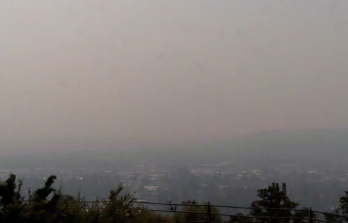
Smoke Information: Visit https://fire.airnow.gov/ for local air quality information.
Flight Restrictions: A Temporary Flight Restriction (TFR) is in place above the Lone Rock Fire area. If you fly, we can’t. Unauthorized drone flights (UAS) pose serious risks to firefighter and public safety and the effectiveness of wildfire suppression operations. Aerial firefighting is suspended when unauthorized UAS are in the area, allowing wildfires to grow larger.
--
Emergency Conflagration Act invoked for Lone Rock Fire
Oregon State Fire Marshal - 07/16/24 9:28 AM
SALEM, Ore. – The fast-moving Lone Rock Fire in Gilliam, Morrow, and Wheeler counties is Oregon’s latest conflagration. On Monday, Governor Tina Kotek invoked the Emergency Conflagration Act. The Oregon State Fire Marshal has been actively engaged on the fire with its partner agencies. Over the weekend, the OSFM sent resources through Immediate Response.
The OSFM’s Red Incident Management Team will be in unified command with Northwest Team 2 starting at 10 Tuesday morning. Structural task forces from Benton, Clackamas, Lane, Linn, Marion, Multnomah, and Yamhill counties are assigned to the fire. The Linn County task force was sent Sunday along with other resources through Immediate Response, a tool the OSFM uses to send firefighters and equipment outside of a conflagration.
“The next few days are going to be extremely challenging with excessive heat, red flag warnings, and forecast lightning,” Oregon State Fire Marshal Mariana Ruiz-Temple said. “We are watching the weather forecast closely and have plans in place if new fires start.”
The Lone Rock Fire 10 miles southeast of Condon sparked on July 13. Gusty winds and dry conditions pushed the fire to grow to more than 30,000 acres as of last report.
The OSFM is actively battling the fire along with its partners from the Oregon Department of Forestry, the Bureau of Land Management, and local responders.
The Gilliam, Morrow, and Wheeler counties sheriffs’ offices have levels 2 and 3 evacuations in place.
Because the threat to homes near the Cow Valley Fire in Malheur County has diminished, the OSFM was able to demobilize and reassign their Red Incident Management Team and several of the task forces.
As the team gets settled in, the OSFM will post updates about the fire to the OSFM Incident Information blog and its social media channels.
--
Governor Kotek invokes the Emergency Conflagration Act in response to Falls and Lone Rock Fires
State Fire Marshal partners with Washington state fire service for additional resources to battle Falls Fire
Salem, OR – Governor Tina Kotek invoked the Emergency Conflagration Act on the morning of July 14, in response to the Falls Fire in Harney County. Governor Kotek also invoked the Emergency Conflagration Act on the morning of July 15, in response to the Lone Rock Fire in Gilliam, Morrow, and Wheeler Counties.
Assistance with life, safety, and structural fire protection was requested by Harney County Judge Bill Hart in response to the Falls Fire, and by the Gilliam and Morrow County Fire Defense Board in response to the Lone Rock Fires. The Oregon State Fire Marshal requested additional resources from the Washington state fire service to help combat the Falls Fire.
“The Oregon State Fire Marshal and the Oregon Department of Forestry are working in concert with each other to protect our state. Critical fire conditions are expected to continue into the coming week,” Governor Kotek said. “Fire incident management teams have been mobilized across the state to manage growing fires in the face of dangerous weather forecasts. Thank you to the Washington fire service for partnering with our state, and to all of the firefighters who are working tirelessly to protect Oregonians.”
"We are bringing in additional support from the Washington fire service for the Falls Fire, the severe drawdown of Oregon resources, and the anticipated weather conditions,” Oregon State Fire Marshal Mariana Ruiz-Temple said. “Our strong relationship with the Washington fire service is invaluable, especially during their responses to Oregon in 2017 and 2020. We have a robust response system that transcends borders and supports our mutual missions. I can't thank the Washington fire service enough for their quick and reliable response to Oregon's needs."
The Oregon Department of Forestry is also augmenting the state’s wildfire suppression resources with personnel and equipment from outside the state. More than 70 out-of-state resources have been ordered so far, with 23 of those ordered through the Northwest Compact. Compact members include Hawaii, Alaska, Washington, Oregon, Idaho and Montana, as well as the Canadian provinces of Alberta, British Columbia, Saskatchewan, and the Yukon and Northwest territories. By creating a cache of reciprocal resources through mutual aid agreements, member agencies can help one another when resources are strained.
A link to Executive Order 24-14, invoking the Emergency Conflagration Act in response to the Falls Fire can be found here.
A link to Executive Order 24-16, invoking the Emergency Conflagration Act in response to the Lone Rock Fire can be found here.
Following ORS 476.510-476.610, Governor Kotek determined that a threat to life, safety, and property exists due to the fire, and the threat exceeds the firefighting capabilities of local firefighting personnel and equipment. The governor’s declaration cleared the way for the state fire marshal to mobilize resources through the Oregon Fire Mutual Aid System to support local fire service agencies on scene.
The Oregon State Fire Marshal mobilized its Blue Incident Management Team and four task forces to the Falls Fire burning 20 miles northeast of Riley to assist in fighting the Falls Fire. Two of the task forces were brought in from Washington state through the Emergency Management Assistance Compact.
The Oregon State Fire Marshal reassigned its Red Incident Management Team and mobilized seven task forces to the Lone Rock Fire southeast of Condon. The agency is working with its partner agencies from the Oregon Department of Forestry, Bureau of Land Management, and local fire agencies to protect life and property.
The Grant and Harney County sheriffs' offices have evacuation orders in place. A map of Harney County evacuations can be found here. Grant County evacuations can be found here.
For evacuation information resulting from the Lone Rock Fire, follow the Gilliam County Sheriff.
--
Gilliam County Sheriff Gary Bettencourt Provides Statement Following City of Lonerock's Close Call with Fire
July 15, 2024
Good afternoon, residents of Gilliam County,
Early this morning, the Lonerock Fire posed an unprecedented threat to the City of Lonerock. I am relieved to report that through the exceptional teamwork of the entire community and the dedicated efforts of local, state, and federal fire resources, we managed to avert what could have been a catastrophic event. The fire came dangerously close to the city and was mere inches away from complete devastation.
I am amazed and deeply grateful for the coordinated response and the resilience demonstrated by our community members, firefighters, and emergency personnel. Their swift action and tireless efforts undoubtedly saved lives and prevented significant destruction.
Though Lonerock was spared, this fire continues to grow into Wheeler and Morrow County, exhibiting erratic behavior.
The City of Lonerock will remain at a Level 3 Evacuation until further notice. This is to protect our citizens and support the efforts of local, state, and federal fire crews who will remain dedicated to monitoring and extinguishing spot fires.
Wildland Fire Safety Instructions:
As we continue to monitor the situation, it is crucial for everyone to remain vigilant and prepared. Please adhere to the following safety instructions:
- Stay Informed: Stay updated on the latest information and advisories from local authorities and emergency services. Monitor local news outlets and official social media channels for updates on the fire's progression and any evacuation notices.
- Follow Evacuation Orders: If evacuation orders are issued, evacuate immediately as directed by law enforcement and emergency personnel. Have an evacuation plan ready and know your evacuation routes.
- Prepare Your Property: Take proactive measures to protect your property from wildland fires. Clear debris from roofs and gutters, trim vegetation around your home, and maintain a defensible space.
- Emergency Supplies: Keep an emergency kit ready with essential items such as medications, important documents, clothing, and non-perishable food and water for each family member and pet.
- Air Quality Awareness: Be aware of changing air quality conditions due to smoke from wildfires. Limit outdoor activities if air quality is poor, especially for individuals with respiratory conditions.
- Report Suspicious Activity: Report any suspicious activity or signs of wildfires immediately to local authorities. Early detection can help prevent fires from spreading uncontrollably.
The safety and well-being of our community remain our top priority.
This community always steps up in times of need and let’s continue to take care of each other and remain connected.
Thank you for your cooperation and stay safe.
Sheriff Gary Bettencourt
Gilliam County Sheriff's Office
--
Monday afternoon announcement from the Umatilla National Forest:
Multiple agencies are responding to the Lone Rock Fire and officials have ordered a Complex Incident Management Team which will transition with the current Type 3 Incident Management Team.
The fire is approximately 9 miles northwest of the Bull Prairie Campground and approximately 8 miles northwest of Fairview Campground in Gilliam County, but is growing towards Wheeler County.
Forest officials are temporarily closing all Umatilla National Forest Lands, Trails and Roads in Wheeler County, as well as both Bull Prairie and Fairview Campgrounds to ensure public safety. This temporary closure will also ensure the safety of firefighters engaged in operations to suppress the Lone Rock Fire.
For more information check out https://bluemountainfireinfo.blogspot.com/