Crazy Creek Fire grows to over 64,000 acres; Paulina placed under Level 2 BE SET evacuation notice
(Update: Sunday fire update; Paulina under Level 2 BE SET evacuation notice)
PAULINA, Ore. (KTVZ) --The nearly 2-week-old Crazy Creek Fire in Crook and Wheeler counties has continued to grow dramatically in recent hot, dry weather to now cover more than 64,000 acres, and on Sunday prompted a Level 2 BE SET pre-evacuation alert to the town of Paulina and nearby areas.
The Crook County Sheriff's Office said in a 1 p.m. Facebook posting: "CCSO Command in conjunction with SWAIMT (SW Area Incident Management Team) 5 has issued a LEVEL 2 evacuation for Paulina proper/southside of Highway 380 from Camp Creek east to the county line."
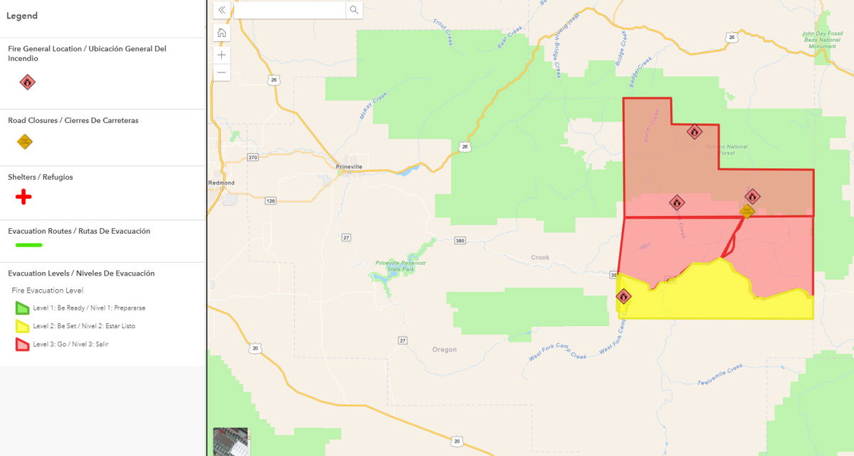
Here's fire officials' Sunday map and update:
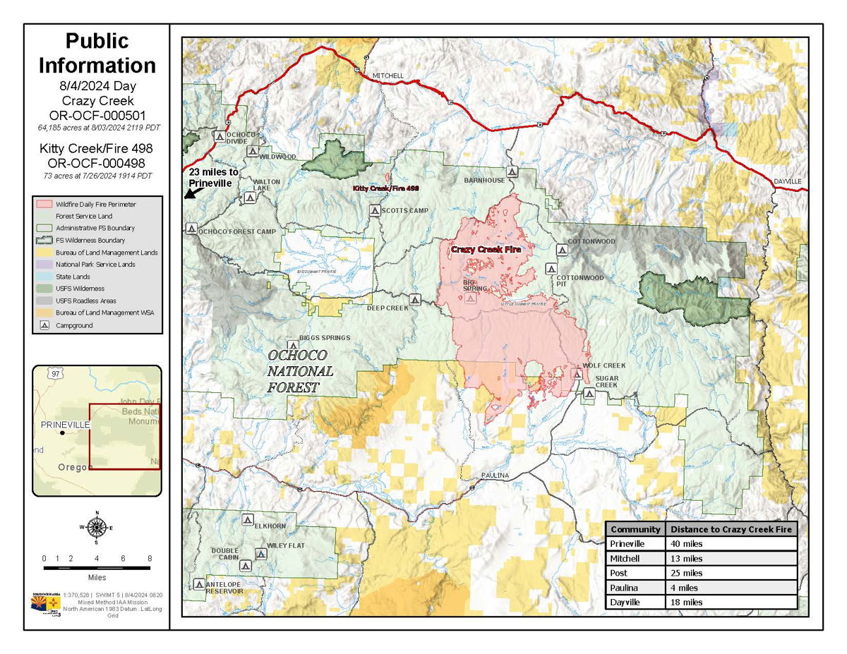
Extensive growth occurs on the Crazy Creek Fire; 498/Kitty Creek Fire reaches full containment
Daily Update August 4, 2024
Fire Information Phone: 541-208-1768 (8am-8pm)
Media Information Phone:541-208-1770 (8am-8pm)
Email: 2024.crazycreek@firenet.gov
Acres: Crazy Creek – 60,091; 498/Kitty Creek – 73
Acreage changes may occur due to overnight operations and infrared mapping.
Location: Crazy Creek: 5 miles north of Paulina, OR Start Date: July 22, 2024
498/Kitty Creek: 7 miles south of Mitchell, OR Personnel: 587
Containment: Crazy Creek 5%; 498/Kitty Creek 100% Fuels: Timber and short grass
Resources: 13 crews | 1 helicopter | 30 engines | 9 bulldozers | 12 water tenders | 3 masticators | 14 skid steers
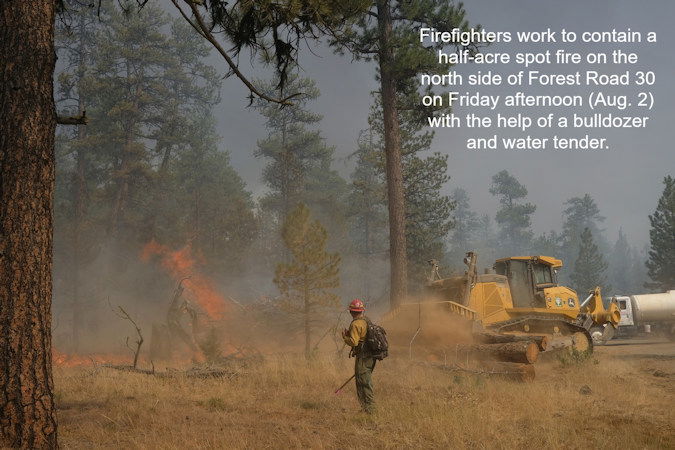
Highlights: The 498/Kitty Creek Fire reached full containment as of Friday, August 2. As challenging conditions persist over the Crazy Creek Fire, firefighters were able to take advantage of a lull in fire activity to strengthen containment lines and make progress constructing holding features along the Forest Service Road 12, in preparation for firing operations. A red flag warning expired at 7 A.M. today, however chances of afternoon thunderstorms may move over the fire area.
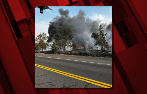
Fire Activity: On Saturday, August 3, fire activity was not as aggressive on the Crazy Creek Fire, allowing firefighters to successfully hold containment lines on the western edge while they worked to contain spot fires near the northern perimeter.
Today, air resources – including large air tankers and helicopters – will support ground operations to reduce the spread of fire on the northern perimeter, east to Toggle Meadows. Firefighters are working to hold and improve existing containment features on the northern and eastern portions of the Crazy Creek Fire, as well as continue mop-up and extinguish hotspots near firelines. Crews on the southern and eastern portions of the fire are scouting for additional containment features and conducting structure protection, including installing sprinkler systems where needed.
Evacuations: Mandatory evacuation orders remain in effect for areas in Crook and Wheeler counties for areas in or near the fire. Level 3 evacuations have extended from the Forest Boundary to Highway 380. Level 2 evacuations have extended south of Highway 380.
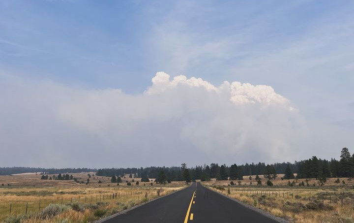
Weather: Critically warm and dry conditions persist with low humidity, temperatures in the mid to upper 90s and scattered thunderstorms.
Importance of Fire Prevention: All public lands in Central Oregon, to include the Ochoco National Forest are in Stage 2 Public Use (Fire) Restrictions. All open flames, including woodstoves and charcoal briquette fires are prohibited. In times of high fire danger, it is crucial for everyone to follow fire prevention measures to avoid additional strain on overburdened resources. The public's cooperation in adhering to fire bans and restrictions is vital to prevent new fires from starting and to help our firefighters focus on containing the existing fires. Learn more at https://www.fs.usda.gov/alerts/ochoco/alerts-notices/?aid=89068.
Smoke: Smoke from multiple fires in Central Oregon are impacting the region. Additional details are available via https://outlooks.wildlandfiresmoke.net/outlook/079f0f73.
Fire Restrictions and Closures: The Ochoco National Forest has implemented a forest closure for the Paulina Ranger District. More information can be found at fs.usda.gov/alerts/ochoco/alerts-notices/?aid=89203. The Bureau of Land Management has issued a temporary closure for public lands in Crook and Grant Counties. More information is available at https://www.blm.gov/sites/default/files/docs/2024-08/orwa-fpo-pri-paulina-080224.pdf.
More Information:
InciWeb: https://inciweb.wildfire.gov/incident-information/orocf-crazy-creek
Facebook: https://www.facebook.com/SWIMT5
Central Oregon Wildfire Information: https://centraloregonfire.org/
Crook County Emergency Information Map: https://arcg.is/1ij0vb