Crews reach 50% containment on 6,500-acre Pine Fire at Pine Mountain; Little Lava Fire tops14,500 acres, 63% contained

(Update: 50% containment; some evacuation levels lowered; firefighter comments; Little Lava update)
BEND, Ore. (KTVZ) – Firefighters on the ground helped by air support have established a bulldozer line around the Pine Fire, which mapping Tuesday determined burned 6,537 acres and by Wednesday had reached 50% containment, officials said.
"The fire stayed within established dozer line overnight," officials said in Wednesday's update. "Today firefighters will continue to secure the perimeter to keep the fire in its current footprint and mop up areas of heat. The fire remains 6,537 acres and is now 50% contained. This is a multiagency response with resources from federal, state and municipal agencies."
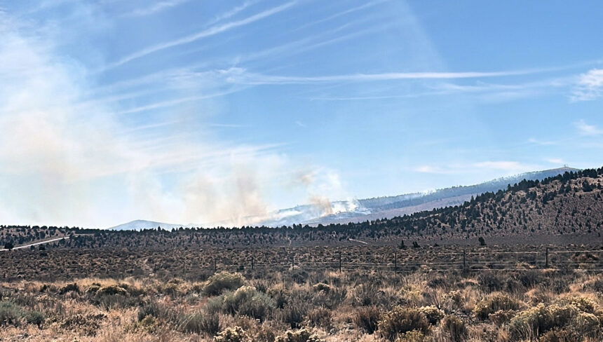
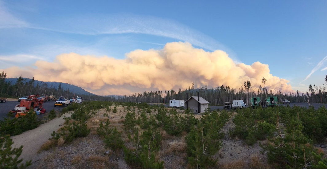
Meanwhile, south of Mount Bachelor, Tuesday's big flare-up on the month-old Little Lava Fire pushed it past 14,500 acres, officials said Wednesday, crews were focused on limiting fire growth to the east, after firefighters got a line around a roughly 100-acre spot fire near Forest Service Road 4188.
Other crews were working with bulldozers to establish control lines along the fire's edge east of FSR 45. Aircraft also assisted in efforts to slow the fire's spread, while crews work to reduce fuels along Forest Road 45 to prep it to use as an eastern control line.
As for the Pine fire, there have been major improvements, but fire crews said Wednesday they're still securing a few hot spots.
"It's cooled off a little bit and much less wind than yesterday and the day before," Brendan O'Reilly, a fire management officer with the Forest Service in Bend. "And then firefighters were just able to make great progress of getting in lines with a combination of hand crews and engines and equipment."
Crews have been fighting the fire since it was discovered late Monday afternoon. The intensity led to Level 2 and 3 evacuations for the sparsely populated surrounding area, which is largely BLM land with a few cattle ranches.
"So we reduced all the evacuation so everybody's able to go home," O'Reilly said. "And we're not really concerned about it spreading onto their private land unless something, you know, really unusual happens."
Fellow firefighter Collin Maclay has been working with a 20-person hand crew for two days, securing the perimeter.
"Definitely doing a lot better, compared to the past couple of days," Maclay said. "Usually grass fires burn pretty quick, and then they go out pretty quick."
A major focus has been to protect the power transmission lines on Pine Mountain, with two out of the three lines re-energized since an initial shutdown.
"We got here yesterday, and then our crews started working on that dozer line coming down, kind of mitigating some of the heavy fuels and stuff, bringing it in, dissipating, like potential threats to the line." Maclay added.
Although progress has been made, there are still some areas being monitored closely.
"So still quite a bit of work to do, especially in the area right below the communication site. There's quite a bit of heavier timber there." O'Reilly explained. "So crews are focusing their energy on protecting the communications site, and then making sure that the fire doesn't spread."
Over the next few days, crews will keep working to extinguish any remaining hot spots and patrol the area.
The cause of the Pine Fire is still under investigation.
Bachelor Complex Update | October 9, 2024
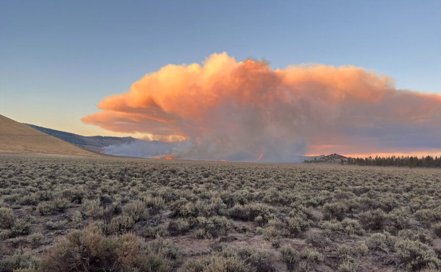
Central Oregon — The Little Lava Fire was very active yesterday due to dry fuel conditions and gusty winds. Currently, the fire is estimated to be 14,529 acres and remains 63% contained.
Weather conditions were favorable today and firefighters made great progress. Dozer line was constructed around the roughly 100-acre slopover that became established east of Forest Service Road (FSR) 45 yesterday near FSR 4188. Just south of the slopover, crews used tactical burning operations along the west side of FSR 45 to remove a pocket of unburned fuel ahead of the main fire to secure this section of the road. Aircraft was very active throughout the day dropping water to limit fire growth and cool hot spots.
Additional resources arrived at the fire today including one hotshot crew, four engines and three dozers. More resources have also been ordered.
Tomorrow, the priority will continue to be limiting fire progression to the east. Firefighters plan to install hose lays along the dozer line and begin mopping up the 100-acre slopover across FSR 45 near FSR 4188. Crews will continue reducing fuels along FSR 45 to prepare the road as an eastern control line. Resources will also continue to look for safe and effective opportunities to engage the fire more directly on the northeastern edge.
Tomorrow’s weather forecast will be favorable for fire suppression efforts. Temperatures are expected to be 60-65 degrees with light easterly winds.
An emergency fire area closure remains in place for the Bachelor Complex to provide for public and firefighter safety. Firefighters have recently encountered members of the public within the closure area which can hinder fire suppression efforts and is unsafe as the fire isn’t fully contained. A map of the current closure area and the order can be viewed here: https://www.fs.usda.gov/alerts/deschutes/alerts-notices
For current wildfire information, the public can visit centraloregonfire.org or follow fire information on X (Twitter) @CentralORFire.
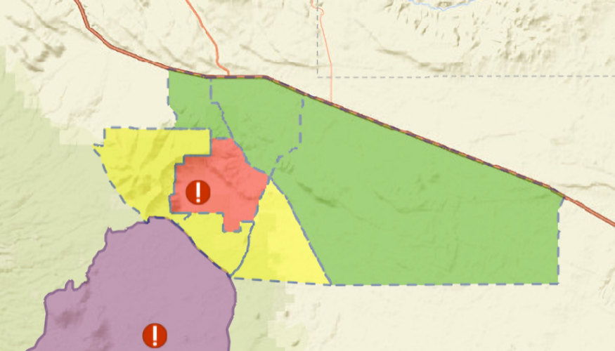
Updated Deschutes County Sheriff's Office evacuation levels: Wednesday, October 9 / 4 PM
Due to improved conditions and success by firefighters, the Deschutes County Sheriff's Office is reducing evacuation levels around the Pine Fire.
Current evacuation levels are:
Level 3: Go Now! - Public lands on and immediately the eastern flanks of surrounding Pine Mountain including Antelope Ridge and private lands in Kotzman Basin (remains unchanged).
Level 2: Be Set - The western portion of Pine Mountain, south to FS Road 23 and south to Sand Springs and the Mahogany Butte Area.
Level 1: Be Ready - Areas north and east of Pine Mountain, south of Hwy 20 from FS Road 2017 (Pine Mountain Rd) to Fredericks Butte Rd.
Current maps can be found at www.deschutes.org/emergency
EARLIER INFO:
A Tuesday night report stated, "Resources have established a preliminary dozer line around the fire and working to further bolster the perimeter to keep the fire in its current footprint. The fire has not had significant growth today, with most of the burning occurring within the interior of the existing footprint. Crews are constructing line directly adjacent to the fire’s edge where feasible."
BLM officials said the fire was likely human-caused, as there has been no recent lightning in the area.
Major power transmission lines in the area were turned off and power rerouted after the fire broke out, blackening the land beneath them. But officials said Tuesday night, "Coordination with power companies has been made and they are re-energizing large high-voltage power lines through the area."
In an update late Tuesday afternoon, officials said, “Our multiple responding agencies have seen no significant growth today and are making good progress. We’re seeing mostly interior burning.”
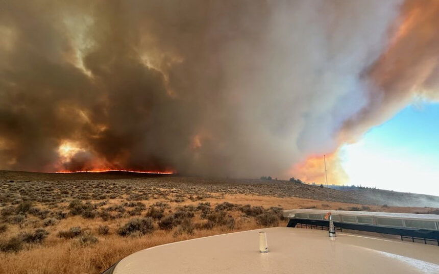
But the situation was far different to the west, as the Little Lava Fire, part of the month-old, more than 13,000-acre Bachelor Complex that was nearing two-thirds containment, blew up on Tuesday amid more dry fuels and gusty winds, showing “very active fire behavior,” Deschutes National Forest officials said Tuesday night.
"Initially, the fire was growing north, and then a wind shift pushed the fire east," the update stated. "The fire is established east of Forest Service Road 45 and south of Edison Butte Sno Park. When the winds shifted, the fire had grown far enough north that the fire was able to push up and around previously established containment lines.
"The area where the fire pushed north and then east was not safe for firefighters or equipment to engage directly," they added. "It’s very rocky terrain with numerous lava flows, making it inaccessible for heavy equipment and difficult to engage on foot. Tomorrow (Wednesday), firefighters plan to suppress the fire’s edge directly east of FSR 45, in coordination with dozers.
Earlier info:
The new Pine fire quickly raced across at least 2,000 acres by nightfall, prompting expanded Level 3 and 2 evacuation alerts for the area, and put up a bright glow visible for many miles through the night.
BLM Announces Emergency Closure Order for the Pine Fire
Bureau of Land Management Ore. & Wash. - 10/08/24 4:44 PM
The Bureau of Land Management (BLM) has issued an emergency temporary closure associated with the Pine Fire, on lands administered by the BLM in central Oregon.
This Emergency Closure Order will remain in effect until such time as conditions allow for safe use of the public lands. Access to the below described lands will remain restricted until further notice.
The following BLM-managed lands in Deschutes County are affect by this closure, including the South Millican Off Highway Vehicle area: T. 20 S., R. 15 E. (all); T. 20 S., R. 16 E. (south of Hwy 20); T. 20 S., R. 17 E. (south of Hwy 20); T. 21 S., R. 15, 16, 17 E. (all)
The signed closure order and map are available online at this link: https://www.blm.gov/programs/public-safety-and-fire/fire-and-aviation/regional-info/oregon-washington/fire-restrictions.
This order is effective immediately.
“We ask that the public to honor this closure, watch for fire vehicle activity on the roadways and be aware there may be significant activity on federal lands,” said Amanda Roberts, Prineville District Manager. “Our main goal is to keep the public, and everyone responding to the Pine Fire as safe as possible. We believe this closure order helps us achieve that goal.”
For more information on Oregon/Washington Fire Closures and Restrictions, please visit: https://www.blm.gov/programs/public-safety-and-fire/fire-and-aviation/regional-info/oregon-washington/fire-restrictions
--
Meanwhile, warm, windy weather kicked up several existing blazes around the region on Monday, spreading more smoke across the High Desert.
Also on Monday, several fires of various causes were stopped at small sizes Monday by firefighters around the Bend-Redmond area.
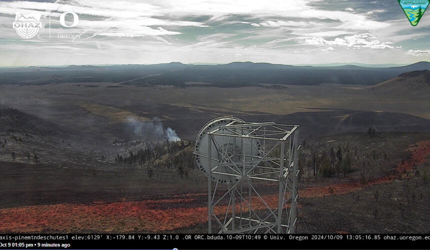
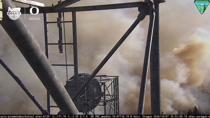
Incident 1002, soon named the Pine Fire, was reported around 4 p.m. on Prineville District BLM land about 22 miles southeast of Bend, in the Kotzman Basin, and quickly put up major smoke visible across a wide area and in dramatic fashion from the AlertWest Pine Mountain camera.
Resources from the Central Oregon Fire Management Service, Oregon Department of Forestry, Brothers-Hampton Rangeland Fire Protection Association and Alfalfa Fire District responded to the fire with several engines, a 10-person hand crew, two bulldozers and overhead resources. Firefighters on the ground were supported by aerial resources including an air attack, air tankers to drop retardant and a Type 1 helicopter to put water on the flames.
Around 8 p.m., officials confirmed in an update that the fire burning south of US Highway 20 was estimated at about 2,000 acres “and remains active on all sides. Additional resources are on order,” and crews will be working through the night, as the fire's nighttime glow can be seen for many miles, including in Prineville to the north.
The cause of the fire is under investigation, officials said.
Visit the official source for wildfire information in Central Oregon at centraloregonfire.org for wildfire updates or follow fire information on X/Twitter @CentralORfire. Call 9-1-1 to report a wildfire.
Pine Mountain might be best known for the University of Oregon-operated observatory at its summit. The facility is closed for the season, but its live camera had another view of the smoke coming from the nearby blaze.
--
You can also track wildfire updates at the Watch Duty app.
Meanwhile, crews were pulled off the northern flank of the Little Lava Fire 15 miles southwest of Bend Sunday afternoon due to increased fire activity. Warm, dry conditions and gusty winds led to several spot fires on the east side of the Edison No. 3 Trail. Crews returned Sunday evening and worked to find and douse spot fires.
Smoke from the Little Lava Fire was very visible Monday from the Sunriver and La Pine areas as the fire kept growing to the region. As of Monday morning, the Bachelor Complex had burned nearly 13,000 acres and was 63% contained.
To the south, near Crescent Lake, stronger than expected winds on Sunday kicked up fire activity on the over 2,800-acre Red Fire, putting up more smoke, along with the neighboring 208 Fire. It’s 15% contained
To the east, the Rail Ridge Fire near Dayville also was actively burning on the northwest flank on Monday, though officials said it remained with containment lines. Plans to use tactical firing operations to finish burning five miles of prepared containment line were delayed due to the stepped-up fire activity and conditions.,
The largest new Bend-area blaze on Monday afternoon around 1:20 p.m. burned about two acres near the Murphy Road and Country Club Drive roundabout, Bend Fire Deputy Fire Marshal Cindy Kettering said. It was traced to smoking materials at a homeless camp in the area.
In Tumalo, a small fire off Tweed Road that burned a 10-by-30 foot ara around 2:30 p.m. was traced to an electric gate controller, Kettering said.
She also advised that the fall burn season won’t open until there’s “meaningful rainfall,” as in several days’ worth.
In Redmond, a fire around noon by the railroad tracks off SE Evergreen Avenue was caused by a failure of Pacific Power equipment, and one power line touching another sent sparks to the dry grass below, Redmond Fire & Rescue Fire Marshal Tom Mooney said.
A brush fire off Crooked River Drive in Terrebonne was caused by the property owner using a burn barrel and the embers escaped through the vent holes, causing the cheatgrass to ignite. The fire was held at about an acre, Mooney said, and the property owner was cited for reckless burning.