Officials detail free removal of hazardous material from burned properties
Lionshead Fire Oregon's sixth-largest in century; Ore. firefighters called to help in California
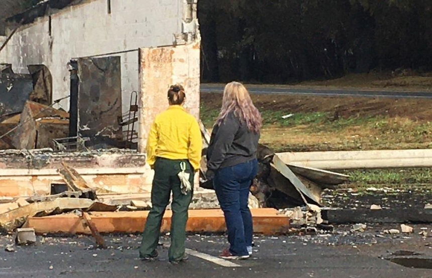
SALEM, Ore. (KTVZ) -- Cleanup from the recent wildfires and wind damage is set to begin in eight Oregon counties as county officials, Oregon’s Debris Management Task Force, and the U.S. Environmental Protection Agency have finalized plans to remove and dispose of hazardous materials from burned properties—free of charge to property owners.
Removal of household hazardous waste and fire debris is required before property owners can rebuild from the fires.
Cleanup crews plan to begin operations in Jackson County the week of Oct. 19 and will expand to the other counties shortly afterward, pending the completion by property owners of “Right of Entry” (ROE) access agreements that will allow cleanup crews onto their property. The ROE for a property must be signed before the county and state cleanup process can begin.
Hazardous waste cleanup is provided free of charge to property owners in Clackamas, Douglas, Jackson, Klamath, Lane, Lincoln, Linn and Marion counties. FEMA and the State of Oregon are funding the work.
Affected Oregon counties are in varying stages of developing their ROE forms. Property owners are urged to check their county’s website (list below) or wildfire.oregon.gov/cleanup for more information about the ROE process in their county. In preparation for filling out the forms, property owners should identify their property parcel number from their county tax assessor’s office and collect insurance information.
Household hazardous waste can include but is not limited to: fuel and petroleum, car batteries, antifreeze, used oil filters, solvents, fertilizers, pesticides, propane tanks, high pressure cylinders, disinfectants, aerosols, paint, bleach, radiological sources or devices, pool chemicals and ammunition. Cleanup crews will also identify and dispose of bulk asbestos materials when possible.
How the process will work
STEP 1: Household hazardous waste removal – No cost to property owner
- Once a property owner completes an ROE form with their county, crews will evaluate the property for any overhead hazards (impacted trees) or other physical hazards and conduct air monitoring and visual observations to identify locations of household hazardous waste.
- Crews will then remove those items from the property for safe disposal.
STEP 2: Ash and debris removal
- Cleanup crews then will remove burned-out structures—possibly including building foundations—ash and other debris.
- When this step is complete, property owners will be able to begin the rebuilding process.
State, county and federal partners are actively working to develop funding and implementation options for Step 2: Ash and debris removal.
The State of Oregon’s Debris Management Task Force is overseeing a coordinated effort by federal, state and local government agencies to address hazardous waste and debris removal. The task force consists of the Office of Emergency Management, Oregon Department of Transportation and Oregon Department of Environmental Quality.
IMPORTANT LINKS FOR PROPERTY OWNERS
- Next steps for people whose homes or businesses burned: https://wildfire.oregon.gov/cleanup
- County wildfire websites (will include Right of Entry forms soon):
- EPA wildfire response: https://response.epa.gov/2020ORwildfireresponse
- How to safely manage ash and debris: https://www.oregon.gov/deq/wildfires/Pages/After-the-Fire.aspx
- Insurance issues and questions: https://dfr.oregon.gov/insure/home/storm/Pages/wildfires.aspx
ODF FIRE REPORT AND FIRE MAP FOR FRIDAY, OCT. 2, 2020
SALEM, Ore. - ODF is closely tracking 6 major fires in Oregon, down from 17 originally (see table below for details). Fires are removed from the list when they are 100% lined and fire managers are confident in their progress toward containment.
Five of the six major fires still on the landscape have burned 100,000 acres or more in Oregon. One of those massive fires, Lionshead, is the sixth-largest fire of the past 100 years in Oregon, at 204,367 acres.
For fire season 2020, there have been 886 fires on ODF-protected lands that have burned 543,382 acres. Prior to 2020, the fire season of 1933—which included the first Tillamook Burn—was the worst on record for ODF-protected lands, with the loss of approximately 340,000 acres. Across all lands in Oregon, there have been 1,995 fires for 1,045,536 acres burned.
Remember that fire season isn’t over yet, which means backyard burning and other restrictions are still in effect on ODF-protected lands. Check the public fire restrictions map to see current restrictions for your area.
| Fire name | Acres burned | Containment | Location |
| Lionshead | 204,355 | 37% | 20 miles W of Warm Springs |
| Beachie Creek | 192,848 | 59% | 15 miles N of Detroit |
| Holiday Farm | 173,094 | 70% | 3 miles W of McKenzie Bridge |
| Riverside | 138,070 | 45% | 2 miles SE of Estacada |
| Archie Creek | 131,542 | 79% | 20 miles E of Glide |
| Slater | 44,495 in Oregon | 50% | 6 SE of Cave Junction (also in No. California) |
Closures
Santiam State Forest is still closed to the public. Before heading out to hunt or recreate on other state or federal public lands, please check to see if there are any restrictions or closures due to the recent fires. There are still portions of highways statewide that are closed. Use ODOT’s TripCheck to plan your route.
More information
- ODF wildfire blog and Significant Fire Potential Map
- Oregon smoke blog
- Northwest Coordination Center – Regional Update and National Situation Report
- Inciweb (information on individual incidents)
State Fire Marshal Mobilizes Resources to California Wildfire Response for Second Time in 2020
Oregon State Fire Marshal - 10/02/20 6:00 AM
The Oregon Office of State Fire Marshal (OSFM) is mobilizing Oregon firefighting resources to assist with the coordinated response to California wildfires, following a request for state-to-state assistance made by California to Oregon.
The OSFM is activating its Agency Operations Center and will be sending six task forces with equipment and personnel to join ongoing firefighting efforts. The task forces were formed on Thursday and are deploying today at 6 a.m.
The mobilized strike teams will be sent from the following counties: Clatsop, Lane, Linn, Marion, Washington, and Yamhill.
As of Thursday, California was currently managing 24 major wildfires across the state, having already recorded 3.9 million acres burned this year, impacting thousands of residents and having incidents threaten lives and structure.
"The Oregon Fire Mutual Aid System (OFMAS) typically mobilizes 15 task forces this time of year to California, given California’s significant losses and continued threat," said State Fire Marshal Mariana Ruiz-Temple. "Oregon will be sending six task forces to California. Our thoughts are with California as they continue to be impacted by these fires. Earlier this month, California sent resources to Oregon to an immediate need on the Almeda fire."
The Pacific Northwest effective yesterday has stepped down to preparedness level 3, meaning the potential for emerging significant wildland fires is normal for the time of year, and there is an adequate availability of firefighting resources and decreased fire activity in the state.
California made its request through the Emergency Management Assistance Compact (EMAC), a national state-to-state mutual aid system. The EMAC request is sent directly to the Oregon Office of Emergency Management. The requests allow for the OSFM to mobilize resources through the OFMAS. The task forces are comprised of Oregon’s structural firefighting agencies, which provide structural firefighting and all-hazards assistance.
Oregon’s structural firefighters mobilized by the OSFM were last sent to California on Aug. 19 to respond to the LNU Lighting Complex, sending three task forces with more than 50 personnel for a two-week deployment to the Napa Valley to support the coordinated response, returning to Oregon on Sept. 2.
This is the fourth year in a row that the OSFM has mobilized resources through the OFMAS and deployed them to support firefighting efforts in California, following requests made through the EMAC.
| Start date: Aug. 16, 2020 | Containment: 37% | facebook.com/LionsheadFire |
| Fire size: 204,367 acres | Public information: 971-277-5075 | https://inciweb.nwcg.gov/incident/7049/ |
Lionshead Fire update for Friday, Oct. 2
REDMOND, Ore. – Active suppression work is continuing on the southwest corner of the fire and around the finger to the north, while patrolling, chipping and backhauling – the gathering up of miles of hose and other tools used to combat the fire – is taking place along large sections of the fire perimeter.
In other work, the roads group cleared a mile or more of the Hwy. 46 corridor Thursday and will continue work today.
Aviation continued to coordinate non-fire flights for fire-related purposes, including a survey of Rocky Mountain goats on Mt. Hood. The Civil Air Patrol finished grid mapping for the Federal Emergency Management Agency.
A previously inactive spot fire located about 10 miles northwest of Breitenbush Hot Springs, within the 2011 Motherlode Fire burn scar, flared up in recent days and has spread to 25 acres. Helicopters dropped water Wednesday and Thursday to slow its progression. Lionshead and Beachie Creek fire managers are monitoring the situation closely and have established a series of trigger points for escalating the response if needed.
Yesterday, Oregon Department of Transportation added an additional pilot car to the Santiam Canyon schedule. The new pilot car schedule for Hwy. 22 is: Detroit to Gates at 7:30 a.m.; Gates to Detroit at 9 a.m.; Detroit to Gates at 11 a.m.; Gates to Detroit at 1 p.m.; Detroit to Gates at 5 p.m.; and Gates to Detroit at 6 p.m.
The road block on Hwy. 22 has been moved to milepoint 46.7 to open access to bathroom and other facilities at Mongold State Park. This area will be used to stage vehicles waiting for the pilot car.
Today, the Willamette National Forest lifted public restrictions on campfires due to increased moisture and cooler temperatures. Personal firewood cutting may resume, but chainsaw use is not allowed from 1 p.m. to 8 p.m., and must be followed by a one-hour fire watch after equipment is shutdown. The Sept. 25 closure order is still in effect. A list of recreation areas within the fire zone that remain closed can be found at https://go.usa.gov/xGpeV
Weather & Fuel Conditions: Most of Thursday’s smoke haze was from the California fires, although there was active burning deep within the perimeter of the northeast corner again. Temperatures will drop slightly today, into the high 70s to low 80s, with light winds continuing.
Evacuations and Closures: Breitenbush Hot Springs remains at Level 3 – “Go!” Detroit, Idanha, Hwy. 22 east of Detroit Dam to milepost 56, and Opal Creek Wilderness/Jawbone Flats are at Level 2 – “Be Set.” Elkhorn, Gates east of Gates Hill Road, and Hwy. 22 from Gates Hill Road east to Detroit Dam are at Level 1 – “Ready.”
Residents of Linn County can find up to date information at www.LinnSheriff.org. All closures on federal lands remain in effect. This includes a 40-mile section of the Pacific Crest Trail between Santiam Pass and Olallie Lake. Closure orders and maps can be found at https://inciweb.nwcg.gov/incident/7049/
