Bootleg Fire, largest in US, tops 200,000 acres; 21 homes, structures lost; area closures extended
(Update: Adding fire officials' morning update, other info on structures lost, transmission lines affected)
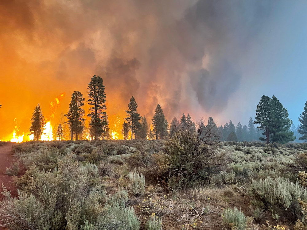
SPRAGUE RIVER, Ore. (KTVZ) -- The week-old Bootleg Fire on the Fremont-Winema National Forest, fueled by heat, wind and drought conditions, has grown to over 200,000 acres, making it the nation's largest wildfire, with numerous homes and other structures lost. Officials on Tuesday announced new closures and evacuations extending into Lake County.
The largest fire in the US has ravaged about 316 square miles, an area more than twice the size of Portland — threatened some 2,000 homes, state fire officials said. It had burned about 21 homes as well as other minor structures, fire spokesman Daniel Omdal said Tuesday.
Firefighters were struggling to build containment lines and hadn’t managed to surround any of the fire burning in the Fremont-Winema National Forest, near the Klamath County town of Sprague River.
“We are under extreme weather conditions. The humidity is low, the fuels are highly flammable and all those provide conditions for significant fire activity,” Omdal said.
The fire disrupted service on three transmission lines providing up to 5,500 megawatts of electricity to California, and that state’s power grid operator asked for voluntary power conservation Monday evening. The operator reported that more than 44,500 megawatts were available Tuesday.
The emergency closure was expanded for the second time in a week due to increased fire activity and movement.
Additionally, the Lake County Sheriff’s Office of Emergency Management has identified areas for Level 3 (Go Now), Level 2 (Get Set) and Level 1 (Be Ready) in western Lake County due to the fire, and is notifying residents and recreating public in the Level 3 area, officials said Tuesday morning.
More information at: https://inciweb.nwcg.gov/incident/7609/
Lake County Evacuations
Level 3 (Go Now)
- South of the Sycan River, south of Forest Roads 3239 and 28, and the Gearhart Wilderness west of Forest Road 3372 in Lake County.
Level 2 (Get Set)
- Sycan Marsh area, Chocktoot Creek Drainage area, west of Forest Road 28 and east of Forest Road 3372, north of Forest Road 34, and through the area that includes Corral Creek Campground and Mitchell Monument.
Level 1 (Be Ready)
- From the northeast at the Lake County line, through the Yamsay Mountain Recreation Area, extending east to the south of Thompson Reservoir to Winter Rim Recreation Area, then south near the Forest Boundary, then following Chewaucan Road south to Forest Road 34.
The evacuation levels include recreation sites in the Fremont-Winema National Forest, as well as private property.
The expanded forest closure order is on National Forest System lands south of Silver Lake Road between U.S. Highway 97 and Oregon State Highway 31; west of Oregon State Highway 31 and U.S. Highway 395; north of the Oregon-California Stateline; northeast of Willow Valley Road, Langell Valley Road, Bly Mountain Cutoff Road, Oregon State Highway 140 and Sprague River Road to U.S. Highway 97; and east of U.S. Highway 97 between Chiloquin and Silver Lake Road.
All roads, recreation sites and facilities are closed within the closure area.
“The Bootleg Fire has moved rapidly through Klamath and Lake counties, with extreme fire behavior driven by hot weather, winds and exceptionally dry fuels since it was discovered last Tuesday,” said Fremont-Winema National Forest Supervisor Barry Imler. “For public and firefighter safety, it is essential that we expand the closure area while firefighters, the Incident Management Team and area fire managers work together to contain and control the fire.”
The closure order is formally referenced as 06-02-21-05. It went into effect Monday night and is in effect until conditions allow or December 31, 2021, whichever occurs first. There will be public notifications when the closure order is lifted.
Area residents and Forest visitors are asked to avoid the fire area and related roads while suppression activities continue. Anyone driving in the area should watch for increased traffic and vehicles associated with wildland firefighting.
Violations of the closure order are punishable by a fine of not more than $5,000 for an individual or $10,000 for an organization, or imprisonment of not more than 6 months or both. For more information on the Fremont-Winema National Forest, visit www.fs.usda.gov/fremont-winema, follow the Forest on Twitter @FremontWinemaNF or on Facebook at www.facebook.com/R6FWNF
SCOFMP Joint Information Center
Bootleg Fire Information Update
Tuesday, July 13, 2021, at 10 A.M.
| Estimated Size: | 201,923 acres |
| Containment: | 0% |
| Start Date/Time: | 07/06/2021 |
| Location: | 15 miles NW of Beatty, Ore. |
| Cause: | Under investigation |
| Personnel: | 1,189 |
| Assigned Resources Hand Crews: Engines: Dozers: Water Tenders: Other Heavy Equipment: | 22 133 11 32 3 |
| Assigned Aircraft: Structure Task Forces: | 10 14 |
| Structures Threatened: | 1,926 |
Phones: 541-363-7765 971-727-7255 541-236-4054
JIC email: scofmpjic@gmail.com
InciWeb: https://inciweb.nwcg.gov/incident/7609/
Facebook: https://www.facebook.com/BootlegFireInfo
Evacuation: https://tinyurl.com/bootlegevac
Beatty, Ore.— The Bootleg Fire burned another 50,000 acres yesterday. Infrared mapping shows the fire size at 201,923 acres. The fire grew by more than three miles, fueled by extreme drought conditions, single-wdigit humidity, and high temperatures.
The weather forecast shows little signs of relief. The National Weather Service issued a red flag warning through 8:00 p.m. on Wednesday. A heat advisory has also been issued until 8:00 p.m. on Tuesday. Fire managers noted the potential for rapid spread in the coming days.
Al Lawson, Incident Commander of PNW Team 10 encouraged the firefighters to adjust their expectations to the new conditions. “As you go out there today—adjust your reality. We have not seen a fire move like this, in these conditions, this early in the year. Expect the fire to do things that you have not seen before.”
Bootleg Fire South Zone (Zone 1)
A new fire started in the Moccasin Hills area yesterday and led to the evacuation of several residents. Local firefighters, both structural and wildland crews, and air support teamed up and quickly suppressed the five-acre fire.
On the southern edge of the fire, crews were successful in keeping the main fire out of populated areas. The fire burned mostly toward the southeast yesterday. Crews built six miles of dozer line toward Obenchain Reservoir. Firefighters continued to connect and improve dozer lines, install hose lays to extinguish hot spots near structures and along the control, and assess and remove fire damaged trees.
The fire is impacting a high-voltage transmission line. Fire officials and representatives with the power companies are working together on plans to safely re-energize the lines as soon as possible.
Bootleg Fire North Zone (Zone 2):
Fire crews on the North Zone of the fire identified and began to suppress three new fires totaling 150 acres in the Summer Lake area. These crews also built dozer line and set up hose lays to keep the fire west of Forest Road 28.
On the fire’s western flank, crews made good progress in improving dozer line and extinguishing hot spots. Last night, crews continued preparations for burn-out operations down the western slope of Fuego Mountain. Along the northern flank, crews are scouting new locations for safe, effective primary and secondary containment lines.
Oregon Office of State Fire Marshal’s Update:
Yesterday, structural fire crews identified and extinguished spot fires around structures. Firefighters on the northeast side of the fire helped safeguard 11 people when winds pushed the fire toward them. Residents and firefighters retreated into a meadow, a safety zone. Once the fire passed, firefighters returned to the area and continued firefighting around the structures. These firefighters also assisted residents in two vehicles when they became trapped by the fire and were unable to escape because of downed trees. The firefighters removed the trees from the roadway, allowing the group to safely escape.
Other crews extinguished small fires around structures along the fire’s south end.
Evacuations: Klamath County (will change on 7/13/21)
Level 3 (GO NOW) Evacuation Notice
- Klamath County, north of the town of Beatty. East side of Godowa Springs Rd north of the OC and E Trail to the Klamath County Line need to leave immediately.
- Klamath County, near the town of Sprague River. Upper tableland area north of Oregon Pines Rd need to leave immediately.
Level 2 (GET SET) Evacuation Notice
- Klamath County, near the town of Sprague River. Klamath Forrest Estates/Moccasin Hills Area need to be prepared to leave.
- Klamath County, West side of Godowa Springs Rd, south of Oregon Pines Rd and Tableland Rd. to the river need to be prepared to leave.
Level 1 (BE READY) Evacuation Notice
- Klamath County, Between Beatty and Bly 3 miles south of Highway 140 from Yellow Jacket Springs to Fishhole Creek need to be ready in case.
- Klamath County, the area from the intersection of Sprague River Rd and Forbes Rd extending east to Godowa Springs and Yellow Jacket Springs and south of the Sprague River 4 miles need to be ready in case.
The Klamath County Sheriff’s Office started to issue citations and will make arrests if necessary to keep people out of the Level 3 evacuation areas.
Closures
The Fremont-Winema National Forest is closed to the public in the fire area. See updated map and the Emergency Fire Closure Order 06-02-21-05 on InciWeb at https://inciweb.nwcg.gov/incident/7609/ or on the forest’s website at www.fs.usda.gov/alerts/Fremont-winema/alerts-notices.
Smoke
New fires in Oregon and northern California are contributing to smoke from the Bootleg Fire, with the probability of increasing the smoke layer. If you are sensitive to smoke, check air quality levels at: https://fires.airfire.org/outlooks/southcentraloregon.
Fire Prevention
With Red Flag Warnings early this week, and exceptionally dry conditions, it is critical that area residents and visitors are extremely careful with anything that can potentially spark a wildfire. This includes not driving or parking on dry grass, following public and regulated use restrictions, ensuring chains aren’t dragging and that tires are properly inflated. A small spark can quickly become a large wildfire in minutes.
If you suspect a wildfire, please call 911 to report it immediately. Help our firefighters focus on the Bootleg Fire and not having to respond to new starts!
