Flat Fire in SW Oregon at more than 31,000 acres, crews reach 28% containment
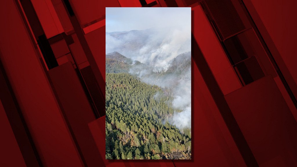
AGNESS, Ore. (KTVZ) -- The nearly 3-week-old Flat Fire on southwest Oregon's Rogue River-Siskiyou National Forest has grown to more than 31,000 acres, but the over 1,100 firefighters on the blaze have brought it to 28% containment as they conduct firing operations to strengthen containment lines.
Here's Thursday morning's update - you can find more information at the fire's Facebook page and InciWeb page:
August 3, 2023
Flat Fire Morning Update
Start Date: July 15, 2023
Size: 31,472 acres
Point of origin: 2 miles southeast of Agness, OR
Containment: 28%
Cause: Human caused
Total personnel: 1,104
Resources: 39 engines l 16 crews l 1 bulldozer l 24 water tenders l 4 masticators l
9 helicopters
Current Situation:
Helicopters continued with aerial ignition to achieve additional depth from the containment line further into the unburned interior in the southwest corner of the fire in the Lawson Creek drainage. With fuels drying out, where fire has been backing down slopes in the recent days and natural fuels lower on the slope align, some uphill runs are now occurring. This results in better overall unburned vegetation consumption, so fuels are less likely to re-burn.
Firefighters also used aerial ignition in the Game Lake area to improve the depth of burned fuels from containment lines. A helitack crew (a firefighting crew flown in by helicopter) was inserted into the Fantz Ranch area along the eastern edge of the fire to cool areas of heat identified through infra-red photography/imaging. This will help to check fire movement further east. Firefighters are monitoring an area of increased interior heat identified through infrared detection in the north fork of Indigo Creek and using helicopter bucket drops as needed to secure the existing containment line. Night-shift resources held and patrolled fireline.
Structure protection resources are using vehicles and aircraft to locate and identify additional homes and buildings, and are collecting data to aid firefighters in protecting structures if there is a future need. The alternate control line on Forest System Roads (FSR) 3313, 1503, and 3680 continues to be improved.
Today’s activities: The aerial ignition efforts over the past several days to gain additional fireline depth between the western and eastern portions of FSR 3680 in the Lawson Creek drainage (southwestern corner of the fire) is planned for completion today. Aerial interior burning will also continue in the Game Lake area as time and conditions allow. A heli-torch will be available to use in areas of more sparse vegetation to increase fuels consumption and overall burn effectiveness. The helitack crew will take additional checking actions in the Fantz Ranch area. The western and northern containment lines, from the junction of FSR 3680 and 3318 to Wildhorse Lookout east to FSR 3577, is being actively mopped up and patrolled. The northeast corner of the fire, using FSR 2308 and 150, has been fully prepared for firing operations if the need arises due to changes in weather conditions and/or fire activity.
With fire traffic on Bear Camp Road, all motorists on Bear Camp Road are asked to slow down, use headlights and proceed with caution.
There is no longer an evening fire update but current information will continue to be posted on Inciweb, Facebook and Twitter.
Evacuations: All remaining evacuation levels are now at Level 1 “Get Ready” evacuation status for all areas in the vicinity of the Flat Fire.
The Curry County Sheriff’s Office will continue to coordinate with the Fire Incident Management Team and will notify all residents affected by the fire of any reasons to change evacuation levels.
Curry County is using Everbridge to send evacuation notices. You can sign up for notifications here: https://www.co.curry.or.us/departments/emergency_management/index.php.
Weather: Today’s forecast calls for slightly cooler temperatures (down 1-3 degrees) and higher relative humidity (up 1-3%). The up and down weather cycle we have been experiencing has moderated fire behavior but overall fuels are continuing to dry. A warmer and drier air mass is predicted to return by the weekend.
Smoke: The Smoke Outlook is available at: https://outlooks.airfire.org/outlook/en/b74901f7
Closures: The Rogue River-Siskiyou National Forest (RRSNF) has issued a closure order for the fire area including trails, roads and a portion of the Illinois River. Oak Flat Campground, Game Lake and Wild Horse Campgrounds and Snow Camp Lookout Recreation Rentals are all closed as part of the area closure. The Chetco River Road (FSR 1376) and Chetco/Pistol River Road (FSR 1407) are now closed. The updated closure allows for public access to the Big Rock swimming hole on the Illinois River.
Restrictions: Fire danger is currently extreme; the RRSNF is implementing Level 2 Public Use Restrictions beginning on August 4. More information can be found here:https://tinyurl.com/bdzbae69.
Please follow all fire restrictions to prevent wildfires. When restricted, smoking is only allowed in vehicles on improved roadways.
