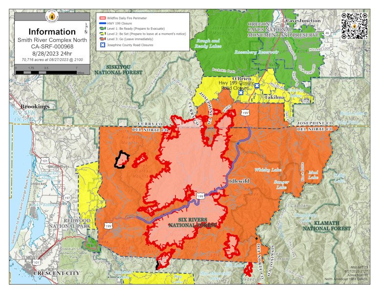
Gov. Kotek invokes Conflagration Act to send task forces to 71,000-acre Smith River Complex at Oregon-Calif. border
SALEM, Ore. (KTVZ) -- Oregon Gov. Tina Kotek has invoked the Emergency Conflagration Act for the 71,000-acre Smith River Complex at the California-Oregon border to allow the Oregon State Fire Marshal to mobilize structural firefighting resources to protect life and property.
The OSFM is mobilizing additional firefighters, equipment, and an incident management team to provide structure protection for homes threatened by the Smith River Complex, which as of Monday was 7% contained.
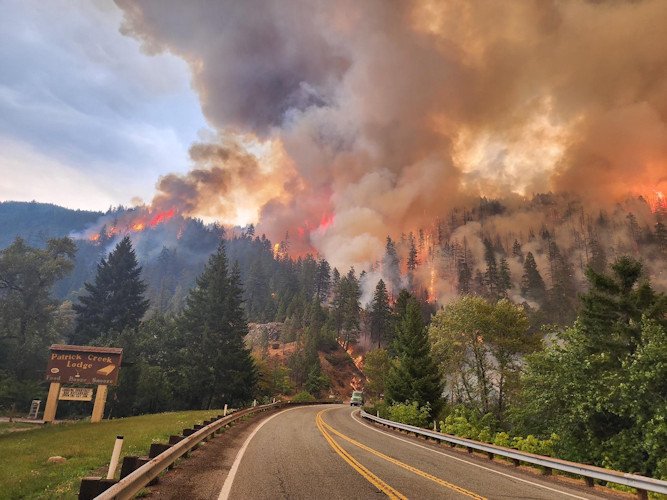
The Smith River Complex began in California and has now burned across state lines into Oregon. Level 3 evacuation orders are in place.
Last Thursday, OSFM mobilized two structural task forces through immediate response to protect communities near the Smith River Complex ahead of a conflagration declaration.
In accordance with ORS 476.510-476.610, Governor Kotek determined that the fire poses a threat to life, safety, and property, and the threat exceeds the firefighting capabilities of local firefighting personnel and equipment. The governor's declaration cleared the way for the state fire marshal to mobilize firefighters and equipment to assist local resources in battling the fire and further support a coordinated response.
The OSFM's Blue Incident Management Team will be briefed and assume unified command of the Smith River Complex on Tuesday at 8 a.m. The additional task forces are coming from other counties around the state through the Oregon Fire Mutual Aid System to protect life and property.
--
Monday's update on the Smith River Complex North Fire - more info available at the fire's InciWeb page:
Smith River Complex North update for Monday, August 28, 2023
GRANTS PASS, Ore. – Saturday evening, firefighters working the night shift on the Smith River Complex North began tactical firing operations on fire lines near Gilligan Butte. Burning fuels between the fire line and the fire is a critical step in securing this line. Night shift firefighters succeeded in firing much of the line west of Gilligan Butte toward the 4402 Road.
Day shift firefighters continued this firing Sunday along the primary containment line on the south and southwest side of Gilligan Butte, reaching the 4402 Road. Currently, firefighters are conducting the same work along the 4402 Road south. These efforts help reduce fire spread that would impact homes in the southern Illinois Valley. Extensive mop-up work will be needed along these lines before they can be considered “contained.”
Smoky conditions continue to restrict aerial operations. Visibility was down to a quarter mile much of the day, making aerial operations unsafe. Firefighters on the ground also struggled with poor visibility. Winds generally from the north are predicted for the next few days and may push smoke to the south, but smoke from other fires in the Pacific Northwest is likely to adversely impact operations throughout the Smith River Complex North.
Firefighters continue to concentrate on protecting the communities and scattered structures near O’Brien and Takilma, and along Lone Mountain Road.
A Level 3 – GO NOW evacuation remains in place for the Hwy 199 area south of O’Brien from milepost 38 to the state line. A Level 2 – GET SET evacuation is in place for O’Brien and the Takilma area. A Level 1 – GET READY evacuation is in place north to Cave Junction. The American Red Cross has set up an evacuation shelter at Rogue Community College in Grants Pass. Livestock can be sheltered at the Josephine County Fairgrounds.
Due to increased fire activity, the public is encouraged to monitor the Rogue Valley Emergency Management site at https://rvem.org for evacuation updates and sign up for Citizen Alert if you have not already done so. An interactive Fire First Response Map showing evacuation areas can also be found there.
Rogue River-Siskiyou National Forest has implemented an area and road closure order for the Smith River Complex. Visit the forest website for additional information at https://tinyurl.com/2s4hymku. The Bureau of Land Management Coos Bay District announced an emergency closure of public lands south of Waldo Road and Happy Camp Road to the Oregon/California border. Additional information can be found at https://www.blm.gov/orwafire.
