Crews bring Eastern Oregon’s massive Durkee Fire to 86% containment, at nearly 295,000 acres
(Update: Monday fire report)
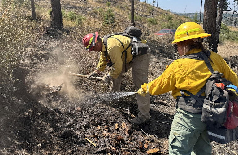
DURKEE, Ore. (KTVZ) -- Crews battling Eastern Oregon's Durkee Fire, the largest in the state so far this season, have reached 86% containment as mop-up and monitoring work continues for the more than 400 firefighters on the lines and in support roles.
Here's Sunday's fire update:
DURKEE FIRE
- Size: 294,690 acres
- Containment: 80%
- Location: 1 mile west of Durkee, OR
- Start Date: July 17, 2024
- Personnel: 432
- Cause: Lightning
Safety is not automatic; think about it, especially as you drive near firefighters and equipment.
Yesterday, firefighters increased containment to 86% using infrared data and an unmanned aircraft system (UAS or drone) to identify and extinguish hotspots. Where possible, crews worked in coordination with resource advisors to repair areas disturbed by wildfire suppression operations. Crews also continued to remove unneeded equipment. These supplies will eventually be returned to one of 15 federal incident support caches where they are refurbished and repaired. Materials are sent out multiple times each year reducing the need to buy new supplies.
New maps have been produced using last night’s infrared flight data to help firefighters identify and extinguish remaining hotspots. Crews will also continue suppression repair and mapping dozer and handlines for future repair. Firefighters and aircraft are available for initial attack if needed.
Weather and Fire Behavior
Today there is a chance of thunderstorms in the afternoon. A prolonged period of above average temperatures and dry conditions begins, increasing fire danger. Relative humidity in the low teens and possibly single digits expected Wednesday and Thursday.
Evacuations
The Malheur County Sheriff’s Office (https://www.facebook.com/profile.php?id=100069245917855) and the Baker County Sheriff’s Office (https://www.facebook.com/profile.php?id=100064434892363) have issued evacuation orders for multiple areas during the Durkee Fire. Please continue to be vigilant and stay tuned to their Facebook pages for the latest information as weather patterns and fire activity may change evacuation levels.
Residents in Level 3 Evacuations “GO NOW” should leave immediately and not return to their property until evacuation levels are lowered. Carry enough supplies to support you and your family for multiple days. A real-time map of fire evacuations is available on the State of Oregon Fire Dashboard (https://www.arcgis.com/apps/instant/portfolio/index.html?appid=22d04c007866419c91ccf00d097526c8).
Closures:
- The Baker County Sheriff's Office has closed Burnt River Canyon Road to non-local, non-emergency traffic.
- I-84 and other highways: Please go to tripcheck.com for current road closures as the situation is dynamic and subject to change.
- A burn ban is currently in effect for all of Malheur County (https://www.malheurco.org/category/public-notices), and all Bureau of Land Management lands in Malheur and Baker counties.
- The temporary flight restriction has been reduced over the Durkee Fire. More information is available at https://tfr.faa.gov/save_pages/detail_4_2285.html. Remember, if you fly we can’t! If a drone or other aircraft enters the air space, all firefighting aircraft will be grounded.
Additional Resources:
- For current air quality information, visit fire.airnow.gov.
- Weather and fire behavior could impact transportation, power transmission, cell service and other utilities. Monitor IdahoPower.com for information.
- Post-fire resources for eastern Oregon livestock and agricultural producers are available. For immediate assistance associated with livestock, forage, and crop losses contact your county’s USDA Farm Service Agency (FSA) office. Learn more about these and other disaster relief programs at www.farmers.gov/protection-recovery/wildfire and contact your FSA Service Center.
- For technical expertise regarding livestock, post-fire rehabilitation and land management, call Eastern Oregon Agricultural Research Center at (541) 573-8900.
- Questions related to agriculture and natural resources, family and community health, and more may be directed to the OSU Extension Service office in your county (https://extension.oregonstate.edu/find-us).
- If you don’t have access to a computer and/or internet connection, Extension offices house Ag Disaster Relief Resource Computers, which are available to producers to access federal/state relief programs.
- Oregon Wildfire Response & Recovery website (wildfire.oregon.gov/recovery) provides guidance on topics including wildfire insurance, filing a homeowners claim after the fire, returning to a home that survived a fire, replacing lost or missing documents and next steps for people whose homes or businesses burned.
- For longer term management needs, contact the USDA Natural Resource Conservation Service (NRCS) field office in your county to explore current funding/technical support available and inform future program offerings in your county. Go to www.nrcs.usda.gov/conservation-basics/conservation-by-state/oregon/whats-available-in-my-county.
