Return of east winds amid heat wave expected to boost fire danger across Northwest as crews battle numerous wildfires
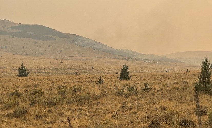
PORTLAND, Ore. (KTVZ) -- A weather pattern bringing an easterly flow of winds is forecast over much of the fire-stricken Pacific Northwest this weekend. With warming temperatures and dropping humidity, conditions are primed for growth on existing wildfires fires and the potential for new starts, the U.S. Forest Service warned Thursday.
Here's the rest of the Forest Service announcement, an Oregon Department of Forestry news release and updates on major fires in the area:
East wind events are common this time of year. They often start in late August, continue into September, and may last into October. These winds flow westward across the Cascade Mountains bringing dry, arid air accelerating fire danger. The severity and duration of east winds varies widely. While these seasonal east winds are not forecast to be as intense as the wind event experienced over Labor Day in September 2020, they may produce some gusts.
With this easterly flow, fire managers expect to see an increase in fire danger. This means new wildfires may be challenging to contain until weather moderates again. Existing fires that have shown little growth and smoke over the last week may become more active. The shifting winds (west to east) may lead to existing fires expanding in different directions, exposing previously unburned forest fuels.
Many national forests are at high or extreme fire danger with campfire bans in place. Please check fire restrictions at your local ranger district before heading out. Even where campfires are allowed, please consider if having a fire is necessary.
Here are few tips to keep yourself, your families, and communities safe during these dangerous conditions:
- Stay vigilant if wildfires are burning in your area or near your community.
- Know that conditions may change quickly.
- Adhere to local fire restrictions.
- Sign up for emergency alerts with your local county.
- Become familiar with the three evacuation levels.
- Know where to find up-to-date evacuation information for your area.
- Make a plan to keep your family safe.
Smoke impacts may increase across Oregon and Washington, including in population centers and areas west of the Cascades that have not had significant smoke impacts yet this summer. For more information on smoke and how to stay safe visit:
--
Fire Season is not over
Oregon Dept. of Forestry - 09/05/24 10:30 AM
Salem, OR— The Oregon Department of Forestry wants to remind Oregonians that with weather fluctuating across the state, fire is still on the landscape and fire season is still in effect. Oregon is still experiencing one of the worst seasons we’ve seen in the past decade, and the department warns the public against complacency.
“East winds are very common around this time of year, making now the time to prevent the next large wildfire. There is still potential for more fire starts and the season isn’t over yet.” Chris Cline, Fire Protection Division Chief, said. “The fewer human caused fires we have, the less strained our resources will be.”
East winds come to the Pacific Northwest every year around the end of August and last through the fall months. They occur from the crest of the Cascades to the Oregon/ Washington coast. Though the winds come annually, significant east wind “events” do not occur every year. If an event does occur, it usually lasts about 48 hours.
Current low humidity combined with sustained winds can increase fire behavior and risk west of the Cascades.
Conditions this week are a mix of warm temperatures, wind, and dry fuels, increasing the risk of wildfire. So far this year, according to the Northwest Interagency Coordination Center, there have been 1,697 fires in Oregon that have burned 1,535,304 acres. Within 24 hours this past weekend, the department deployed two incident management teams to assist with fast growing fires in Klamath (Copperfield Fire) and Wheeler (Shoe Fly Fire) Counties.
If the Oregon Department of Forestry knows that an east wind event is going to happen, which can be determined at least 5 days in advance, the agency will preposition resources, adjust schedules, and take necessary precautions to respond to new starts or increased fire behavior quickly.
“With the approaching fall like conditions, it’s easy to think that fires are lessening. However, we are still seeing new fire starts daily throughout the state of Oregon.” Cline said.
Wildfire prevention means:
- Debris burning is prohibited during fire season without a permit. Cover your pile and wait until fire season is over. A dry, covered pile is cleaner and safer to burn later, during wet fall and winter conditions.
- Don’t park your car over dried grass, and make sure your vehicle or ATV is regularly serviced.
- Dispose of your cigarette using designated receptacles, and NEVER discard butts on the ground or in vegetation outdoors.
- Check local restrictions before lighting a campfire.
Several ODF districts have updated their fire danger levels recently. Visit Oregon.gov/odf to find local fire restrictions and keeporegongreen.org for more wildfire prevention tips.
--
Wiley Flat Fire Update – September 5, 2024
Acres: 15,962 Acres; 0% Contained
Location: 10 Miles southeast of Post off Highway 380
Start Date: September 2,2024 Personnel: 160 Cause: Lightning
Resources: 7 crews | 6 engines | 4 water tenders | 1 skidgine | 8 dozers
Highlights: California Complex Incident Management Team 1 will assume command of the Wiley Flat Fire tomorrow, with an in-briefing scheduled for 3 p.m. today.
Yesterday, firefighters prioritized structure protection, utilizing both aerial and ground resources to scout potential control line locations around the fire’s perimeter. Crews successfully established and anchored lines on the west side of the fire, setting a foundation for containment.
Today, operations on the north side of the fire will focus on completing and securing the established fire lines while scouting for opportunities to use a direct approach against the fire. On the south side, firefighters will continue to complete and hold fire lines around private properties while looking for indirect firefighting opportunities to contain the fire’s spread.
With extreme fire behavior expected today, the public should anticipate seeing heavy smoke and visible smoke columns throughout the region. Firefighters remain prepared to adjust strategies as needed to maintain safety.
Weather: A heat advisory is in place. The high today is 96 degrees, with Southeast winds of 3 to 6 miles per hour and a minimum humidity of 5 to 10 percent.
More Information:
InciWeb: https://inciweb.wildfire.gov/incident-information/orocf-wiley-flat
Facebook: https://www.facebook.com/profile.php?id=61565121969460
Evacuations: The Crook County Sheriff’s Office has issued Level 3 (GO NOW) evacuation orders for areas from SE Pine Creek Road (FS RD 17) east to SE Camp Creek Road, and from Paulina Highway south to the southernmost portion of SE Camp Creek Road, including SE Tackman Road and Antelope Reservoir. Residents in these areas should evacuate immediately. Additionally, Level 2 (BE SET) evacuation orders cover SE Camp Creek Road east to the south fork Crooked River and south to GI Ranch Road.
For the most current evacuation information, please visit the Crook County Sheriff’s Office webpage and Facebook Page.
Closures: Both the Ochoco National Forest and BLM have implemented partial closures due to the fire. For more details and closure maps, visit the Ochoco National Forest and BLM webpages.
Importance of Fire Prevention: All public lands in Central Oregon, including the Ochoco National Forest, are in Stage 2 Public Use (Fire) Restrictions. All open fires, including woodstoves and charcoal briquette fires, are prohibited. In times of high fire danger, it is crucial for everyone to follow prevention measures to avoid additional strain on overburdened resources.
Visit the official source for wildfire information in Central Oregon at centraloregonfire.org for wildfire updates or follow fire information on X/Twitter @CentralORfire. Call 9-1-1 to report a wildfire.
--
RAIL RIDGE FIRE DAILY UPDATE
Thursday, September 5, 2024
Fire Information Line – 573-368-8227
centraloregonfire.org x.com/CentralORFire
Size: 82,947 acres Location: South Fork of the John Day River; Grant, Crook, Wheeler Counties
Start Date: Sep. 2, 2024 Containment: 0% Cause: Lightning Total Personnel: 500
Dayville, Oregon — The Rail Ridge Fire started near the South Fork of the John Day River around Martin Creek and quickly moved into the Murderers Creek drainage. Several lightning-caused fires combined with the Rail Ridge Fire. Wildfires designated as 778 Fire, 761 (Rail Ridge) Fire, 779 (Powell) Fire, and 796 (Black Canyon) Fire are now being managed as one wildfire response. Full suppression strategy will be used where possible and with firefighter and public safety in mind.
Yesterday’s Activities – Firefighting operations focused on aggressively building fire perimeter where safe for fire personnel. Natural barriers, existing roadways, and established fuel breaks continued to be utilized to stop or slow spread along the perimeter of the fire.
Conditions remained too smoky for aircraft operations, but smoke shading and light winds provided opportunity to make progress in slowing fire spread and establishing control lines for upcoming operations. Strategic burning operations were utilized to remove unburned fuels between defensible barriers and the active fire front.
- On the north part of the Rail Ridge Fire, the focus was stopping the fire from spreading into the Deep Creek drainage to keep the fire away from structures in this area.
- Along the west side of the Rail Ridge fire, firing operations were used to connect lines that were built over the last few days. Crews continued strategic structural point protection, as safe to do so, while continuing to stop the fire’s spread along these planned lines.
- On the south part of the fire, similar operations to the western side were put in place. Rangeland Fire Protection Association resources provided dozer support to build lines.
- On the east side of the fire, structure protection and firing operations were also used to slow the spread of the fire. Mechanical equipment was used to reduce fuel loading along planned control lines.
Today’s Activities – Firing operation on the eastern flank may create smoke visible from nearby areas. More crews, engines, and heavy equipment will be arriving today. Firefighters will continue to focus on building new line where needed and strengthening the existing fire barriers that have been established. State, local, and federal resources are working in the north side to control the fire spread and establish structure protection. Smokejumpers were sent to Aldrich Mountain to secure the communication site.
Weather – A warming and drying trend will continue to dry out fuels, further increasing the likelihood of new ignitions and active fire behavior. For Friday, the temperatures will be in the high 90s with continued low moisture levels.
Evacuations —
- The Crook County Sheriff’s Office has lowered evacuation levels from Level 3 to Level 2 in areas south of Highway 380. However, areas around SE Puett Road and the perimeter of the Crazy Creek Fire remain under Level 3 (Go Now) status. For the latest updates, visit the Crook County Emergency Management website and Crook County Sheriff’s Office Facebook page.
- Wheeler County: The Wheeler County Sheriff’s Office continues to monitor fire activity. The area near Beaver Creek Road remains at Level 2 (Be Set), with areas around the fire perimeter still under Level 3 (Go Now) orders. Visit the Wheeler County Sheriff’s Office Facebook page for real-time updates.
- Grant County: A Level 3 “Go Now” alert remains in effect for areas around the Rail Ridge Fire, with Level 2 “Be Set” and Level 1 “Be Ready” advisories for other areas. For the most up-to-date evacuation information, visit the Grant County Emergency Management Facebook page.
- Please contact your local Sheriff’s Office to sign up for evacuation alerts.
Closures:
- The Malheur National Forest has implemented a partial closure order for the Blue Mountain Ranger District.
- The Ochoco National Forest has implemented a partial closure order for the Paulina Ranger District.
- The Bureau of Land Management has implemented a partial closure for lands managed in the Paulina Valley area.
- Oregon Department of Fish and Wildlife has implemented closures of the Phillip W. Schneider Wildlife Area.
- Visit the Oregon Department of Emergency Management website to view a map of active fires, evacuation alerts and closed areas.
Fire Restrictions –
- All public lands in Central Oregon, including the Ochoco National Forest, are in Stage 2 Public Use (Fire) Restrictions. All open fires, including woodstoves and charcoal briquette fires, are prohibited.
- Malheur National Forest is in Public Use Restrictions Phase C and can be viewed on the Forest’s website.
More Information:
InciWeb: https://inciweb.wildfire.gov/incident-information/orocf-rail-ridge
Facebook: https://www.facebook.com/profile.php?id=61565474339343
Visit the official source for wildfire information in Central Oregon at centraloregonfire.org for wildfire updates or follow fire information on X/Twitter @CentralORfire. Call 9-1-1 to report a wildfire. Smoke from the Rail Ridge Fire continues, and maps and air quality information are always available on https://fire.airnow.gov/. Please help firefighters by following all local regulations, found here: https://www.oregon.gov/odf/fire/pages/restrictions.aspx. Additional wildfire prevention tips are available at www.keeporegongreen.org.
--
Copperfield Fire
Morning Update
SEPTEMBER 5, 2024
Fire information resources:
FOR IMMEDIATE RELEASE Inciweb: Copperfield Fire - OR98S
Facebook: Copperfield Fire 2024
Email: CopperfieldFire2024.Info@gmail.com
Phone: 541-233-6967 (8 am to 8 pm)
Chiloquin, Ore. – Yesterday and last night, fire crews expanded the cold black perimeter of the fire, extending hose lines and cooling hot spots along the fire line to achieve 26% containment. Most of the fire growth was due unburnt pockets consuming fuels within the fire lines to assist in containment. Hot spots putting up smoke are still visible within the footprint of the fire, which is being addressed by aircraft water drops as well as crews working further into the main fire. The goal for containment is 100’ feet around the perimeter.
Today the focus will be on preparing for a change in weather. Later this afternoon there will be an increase in SE winds, low humidity, and higher temperatures, which will increase the risk of spot fires. Task forces will continue supporting structure protection and mop up in wildland sections of the fire. The wildland crews will continue to strengthen the western perimeter of the fire to hold the present footprint.
The Oregon State Fire Marshal (OSFM) will be demobilizing two task forces today from Washington and Lane Counties to return to their local fire departments. Today will also be the last full shift for OSFM; the remaining task forces and OSFM Incident Management Team members will return to their home agencies on Friday. ODF Team 3 will remain in command of the fire. Hundreds of wildland resources, along with local resources, will continue mop-up operations, containment efforts, and structure protection.
Evacuation levels will continue to change with the increase of the fire containment. Evacuation levels are determined by the Klamath County Sheriff's Office in conjunction with fire officials and agency administrators. Current evacuation areas and levels can be found at https://www.klamathcounty.org/300/Emergency-Management.
