Warm late-winter storm brings rain and wind, sends Central, Eastern Oregon rivers over their banks, closes highways
(Update: Highway 20 in E. Oregon to remain closed overnight, Added video)
BEND, Ore. (KTVZ) – The storm that brought high winds, rain and warmer temperatures to Central and Eastern Oregon late Monday and early Tuesday sent trees falling, snow melting and rivers rising, closing or impacting several highways and many travelers across the region.
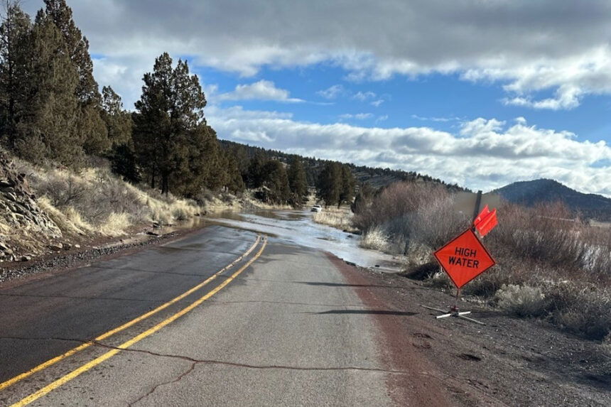
State Highway 380, the Paulina Highway, was closed for a time Tuesday morning southeast of Prineville near the Crooked River at milepost 16 due to flooding, ODOT reported.
ODOT at first advised to use an alternate route, but Region 4 Public Information Officer Kacey Davey told KTVZ News at midday that conditions had improved and high-clearance local traffic was again being allowed through.
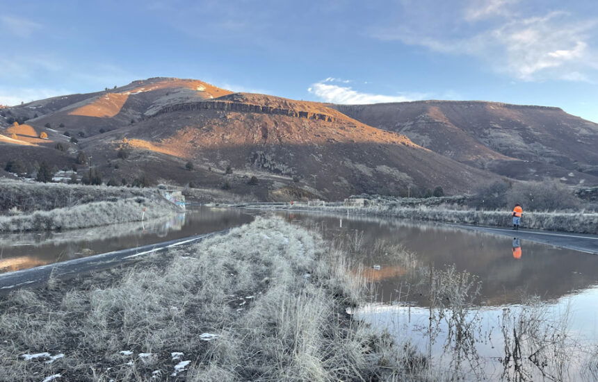
Drone footage shared with KTVZ News by Seth Tooley showed the extent of flooding along the Crooked River.
In Eastern Oregon, flooding from the Malheur River kept a 33-mile stretch of U.S. Highway 20 closed between Juntura and Harper. ODOT said crews reported 3-5 feet of water on the road at one spot.
ODOT said in an update late Tuesday afternoon that Highway 20 will remain closed through the night due to water over the road in several areas. Crews worked at the deepest spot to start draining water and removing debris and will assess the situation again on Wednesday morning.
“Other roads in southeast Oregon may also be affected by flooding,” ODOT said. “Slow down and drive with caution. Do not drive through water.”
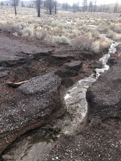
On the Deschutes National Forest south of Bend, a portion of Forest Service Road 18 - known as China Hat Road - was washed out Monday by the rain and flooding, prompting its closure until temporary repairs can be completed. That’s expected to take over a week, until Thursday, March 6.
More repairs will be needed this summer or fall to fully repair the damage from recent storms, installing a larger culvert and rebuilding the roadbed, Forest Public Affairs Officer Kaitlyn Webb said.
Webb added, "Recent precipitation across the Deschutes National Forest has impacted road conditions. The public is advised to travel with caution or avoid using roads and trails that have standing water or deep mud, as this creates resource damage that must be repaired."
Those seeking more information about the temporary road closure were urged to contact the Bend-Fort Rock Ranger District at (541) 383-5300.
Meanwhile, the National Weather Service issued a flood warning late Tuesday morning for the John Day River at Service Creek in Wheeler County, warning that the warmer temperatures were melting snowpack and increasing river flows.
NWS forecasters in Pendleton said the river had risen to nearly 12 feet; 10 feet is when it can begin to top its banks. It’s expected to fall back below the 11.5-foot flood stage by late Tuesday evening. The river reached its record flood level on March 14, 1983, when it rose to nearly 13 feet.
A high wind warning for Central Oregon remained in place through 4 p.m. Tuesday as forecasters advised of southwest winds 20-30 mph with gusts of 45-60 mph.
The winds also affected Central Oregon travel, as U.S. Highway 97 was closed near Chiloquin Monday afternoon due to a downed tree and power line. Get ODOT TripCheck updates on our page at KTVZ.COM.
The storm that swept across the Northwest knocked out power to tens of thousands in the Portland area.
Pacific Power said crews had restored power to all but about 3,500 Oregon customers by midday Tuesday, mostly in Western Oregon, though about two dozen customers west of Bend lost power Monday night due to fallen trees. They were expected to be restored by Tuesday evening, according to the Pacific Power outage map.
