Lionshead Fire nearly 15,000 acres; Level 2, 1 evacuation alerts in Camp Sherman area
(Update: Level 2, 1 evacuation alerts in Camp Sherman area, campgrounds
Deschutes, Willamette national forests close much of Mt. Jefferson Wilderness Area, 40-mile stretch of Pacific Crest Trail
WARM SPRINGS, Ore. (KTVZ) -- The Lionshead Fire grew to nearly 15,000 acres Saturday as it kept spreading west, prompting Level 2 and 1 pre-evacuation alerts in the Camp Sherman area and nearby campgrounds and closures on the Mount Jefferson Wilderness Area and 40 miles of the Pacific Crest Trail.
Fire officials said Saturday night the fire had grown to 14,967 acres and remained at 31% containment.
Here's the evacuation alert issued around 9 p.m. Saturday by Frontier Dispatch:
Level 1 Evacuation Notice "BE READY" and Level 2 Evacuation Notice "GET SET"
The Lionshead wildfire continues to grow and Sunday's weather events are raising concern. A level 1 Evacuation Order is now in effect for the Camp Sherman area south of Allingham Bridge, Monty Campground and Perry South Campground. Areas in the Level 2 are campgrounds north of Allingham Bridge, as well as campgrounds and dispersed camping to the west on USFS lands by request of USFS.
Residents should be aware of the danger that exists in their area, monitor emergency services websites and local media outlets for information. This is the time for preparation and precautionary movement of persons with special needs, mobile property and (under certain circumstances) pets and livestock. If conditions worsen, emergency services personnel may contact you via an emergency notification system.
Those persons who will need additional time to exit an area or have health conditions (especially respiratory conditions that could be made worse by smoke) should consider leaving now. You are encouraged to prepare or even move livestock and pets out of the area. Be prepared to leave if conditions worsen.
This order is authorized by Sheriff Jim Adkins of the Jefferson County Sheriff's Office.
Approved Oregon Evacuation Levels
LEVEL 1: A Level 1 Evacuation means “BE READY” for potential evacuation. Residents should be aware of the danger that exists in their area, monitor emergency services websites and local media outlets for information. This is the time for preparation and precautionary movement of persons with special needs, mobile property and (under certain circumstances) pets and livestock. If conditions worsen, emergency services personnel may contact you via an emergency notification system.
LEVEL 2: A Level 2 Evacuation means “BE SET” to evacuate. YOU MUST PREPARE TO LEAVE AT A MOMENTS NOTICE This level indicates there is significant danger to your area, and residents should either voluntarily relocate to a shelter or with family/friends outside of the affected area, or if choosing to remain, to be ready to evacuate at a moment’s notice. Residents MAY have time to gather necessary items, but doing so is at their own risk. THIS MAY BE THE ONLY NOTICE THAT YOU RECEIVE Emergency services cannot guarantee that they will be able to notify you if conditions rapidly deteriorate. Area media services will be asked to broadcast periodic updates.
LEVEL 3: A Level 3 Evacuation means “GO” Evacuate NOW LEAVE IMMEDIATELY! Danger to your area is current or imminent, and you should evacuate immediately. If you choose to ignore this advisement, you must understand that emergency services may not be available to assist you further. DO NOT delay leaving to gather any belongings or make efforts to protect your home. THIS WILL BE THE LAST NOTICE THAT YOU RECEIVE Entry to evacuated areas may be denied until conditions are safe. Area radio and TV stations have been asked to broadcast periodic updates.
Here's Saturday's earlier updates on the Lionshead and P-515 fires, as well as the Beachie Creek Fire in the Opal Creek Wilderness north of Detroit and the White River Fire west of Wamic on the Mt. Hood National Forest:
Quick Facts
Incident Summaries
P-515 / Lionshead
Approximate
Size in Acres: 4,609 ac. / 11,777 ac.
Fire
Containment: 95% / 31%
Incident
Commander Alan Lawson
Resources on
the fire:
Crews: 15
Helicopters: 7
Engines: 28
Water Tenders: 16
Dozers: 5
Total
Personnel: 532
Jurisdiction:
Confederated Tribes of
Warm Springs
Oregon Smoke Blog
http://oregonsmoke.blogspot.com/
Facebook
https://www.facebook.com/KWSOnews
https://www.facebook.com/northwestteam10/
InciWeb
https://inciweb.nwcg.gov/incident/7050/
https://inciweb.nwcg.gov/incident/7049/
For Immediate Release: Saturday, September 5, 2020
Incident Commander: Alan Lawson, Northwest Team 10
E-mail – 2020.p515@firenet.gov
Fire Information: 971-277-5075
Warm Springs, Oregon - This update is for the P-515 and Lionshead Fires, burning on the Warm Springs Reservation. Both fires are being managed for full suppression.
Current Status: The perimeter of the P-515 Fire is completely lined. Hand crews will improve existing containment lines, locate and mitigate hazard trees and grid and patrol for spot fires within existing hand and dozer lines to meet agency standards.
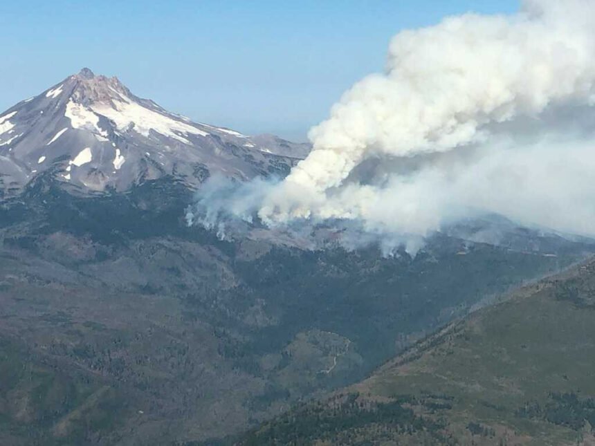
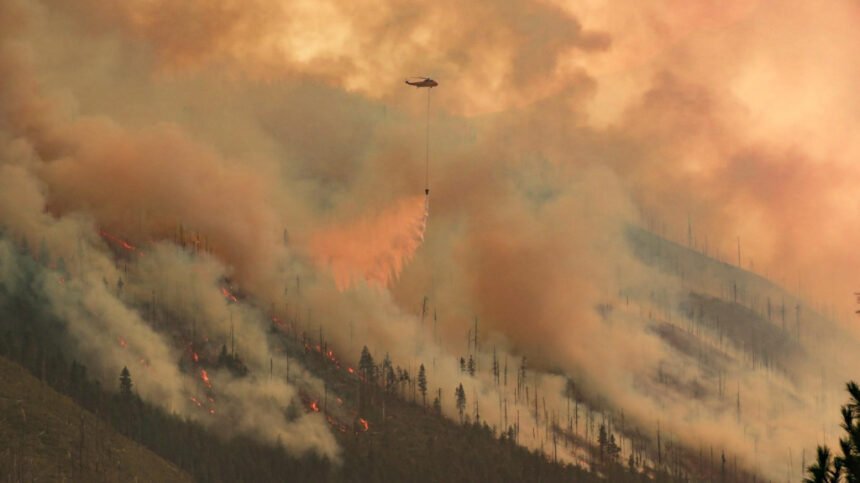
The Lionshead Fire is now 11,777 acres and 31% contained. The fire remains within the control lines on the northern, eastern, and southern perimeters, where crews are mopping up and securing control lines. Active fire continues within the Whitewater River drainage, pushing westward. The southwest flank of the fire has crossed Parker Creek. A thermal inversion, resulting in poor visibility, limited the use of helicopters on the fire yesterday.
Today’s Operations: In the southwest section of the Lionshead Fire, noted for its steep and complex terrain, crews will scout for safety zones and opportunities for indirect and contingency line construction. Fire crews face continued challenges due to the difficult terrain, high temperatures and dry conditions. Masticators are being used to improve roads in the area to serve as primary or contingency lines. Elsewhere on the fire, crews are conducting mop up operations along all containment lines and spot fires.
Weather and Fire Behavior: A low pressure system, dipping south from Canada, will be accompanied by gusty winds and even drier air. This will put the incident area in near - Red Flag Warning weather conditions by Monday. Gusty winds and fingers of dry continuous fuel in Milk Creek, Parker Creek and Whitewater River drainages, on the fire's western edge, could trigger spot fires and test control lines.
Closures: Trout Lake Road at pavement end; Road B-140 at Potter’s Pond; Road B210 and Road P-500. All trails south of Trout Lake, west of M-120 Metolius Bench, east of Mt. Jefferson, and north of J-195 will be closed to the public. Tenino Road (P-200) is closed to the public, with only fire personnel and residents permitted. See Willamette and Deschutes N.F. websites for trail and area closures.
A Temporary Flight Restriction is in place over the P-515 and Lionshead Fires. Wildfires are a No Drone Zone.
COVID-19: Our highest priority is the safety of the public and all wildland fire personnel. To keep firefighters and communities healthy and safe during the P-515 and Lionshead Fires, all fire personnel are expected to follow recommendations from the Centers for Disease Control and Prevention (CDC). This includes limiting public access to the Incident Command Post (ICP) at the Warm Springs Fairgrounds. While COVID-19 circumstances are rapidly evolving, and federal agency guidance continues to adapt with the situation, NW Team 10 is prepared for wildland fire activity during this time.
Prevention Message: The public is urged to drive cautiously this Labor Day Weekend as fire crews continue to travel on the highways working on the Lionshead and P-515 fires.
Deschutes National Forest Announcement:
Deschutes National Forest to extend closures in Mt. Jefferson Wilderness due to Lionshead Fire
Sisters, Ore. -- Beginning this (Saturday) afternoon, the Sisters Ranger District of the Deschutes National Forest will close a portion of the Mt. Jefferson Wilderness due to the continuing threat of the Lionshead Fire.
The area being closed includes all Deschutes National Forest lands within the border of the Mt. Jefferson Wilderness, from north of Jack Lake to the border with the Confederated Tribes of the Warm Springs Reservation. This includes all areas accessed by the Jefferson Lake, Brush Creek, and Bear Valley trailheads. The Jack Lake Trailhead, campground and area remains open.
Visitors should abide by this closure to avoid potential injury and create unnecessary risk to others. The closure will remain in place until the wildfire is no longer a threat to these areas.
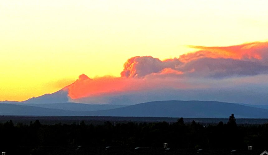
Individuals concerned about the large smoke column in the Sisters and Camp Sherman area should be assured that the Green Ridge Fire remains 100% contained and all smoke is from the Lionshead Fire.
Willamette National Forest announcement:
Lionshead Fire to close popular sites across the Mt. Jefferson Wilderness
Springfield, OR, Sept. 5, 2020 -- Active fire behavior is pushing the Lionshead Fire on the Warm Springs Reservation west towards the Willamette National Forest. The Forest is preparing a closure order that will encompass a portion of the Mount Jefferson Wilderness, notably including approximately 40 miles of the Pacific Crest Trail, Jefferson Park, and the Whitewater and Pamelia Lake trails.
“With current dry and windy conditions, along with critical fire weather anticipated in the coming days, we are concerned by how the Lionshead Fire may spread,” said Willamette Forest Supervisor David Warnack. “We want to ensure people have enough notice to get out of the Forest safely and ask those who have scheduled trips to this area to develop alternative plans.”
For public safety, Detroit Wilderness Rangers are currently advising visitors in Jefferson Park and Pamelia Lake areas of the forthcoming closure. The entire Willamette National Forest is under an “extreme” Fire Danger Adjective Class. This means all fires are potentially serious and can spread quickly. Visitors are reminded that the best way to support firefighters with ongoing suppression efforts is to respect fire closures. Fire prevention is everyone’s responsibly and fire personal use restrictions are in effect across the Forest.
Visit: https://inciweb.nwcg.gov/incident/7049/ for more information on the Lionshead Fire. Visit: https://go.usa.gov/xGDq5 to view the forthcoming closure. Visit: https://www.fs.usda.gov/main/willamette/fire for a list of personal use restrictions and to find fire closure orders and follow us on Facebook and Twitter @WillametteNF.
Beachie Creek Fire Update for Saturday, September 5, 2020
Beachie Creek Fire Wildfire
News – 3 hrs. ago
Beachie Creek Fire Update for Saturday September 5, 2020
Brian Gales, Incident Commander
Lonnie Click, Deputy IC
Start date: Aug, 16, 2020
Location: Opal Creek wilderness, 6 mi North of Detroit OR
Cause: Unknown
Fire size: 379 Acres
Total personnel: 54
Gates, Ore. – Fire management personnel are preparing approximately 20 structures for protection in Jawbone Flats. Aviation resources are being used to slow the progression of the head of the fire in order to provide further protection for local communities.
Firefighters are also assessing French Creek Ridge for strategic actions using aviation and ground resources to moderate the fire movement to the south and southeast. Ground resources are also engaged in the Cedar Creek drainage to manage fire advancement to the west.
Yesterday morning smoke had settled above the fire creating a cap slowing fire spread. The cap lifted and by 2:00 p.m. smoke was once again affecting areas of Detroit, Jawbone Flats and communities in the Little North Fork an Elkhorn Valley. Smoke from the Lionshead and P-515 fires on the Warm Springs Reservation may continue to linger.
WEATHER: High pressure remains anchored over the region with warm temperatures and dry conditions expected through the weekend. Temperatures will be slightly cooler on Saturday.
SAFETY: Highway 22 will be crowded with trucks, cars, trailers, and fire equipment. Keep your lights on, be aware of other drivers. Get to your destination safely and enjoy your holiday weekend.
RESTRICTIONS: Campfires are restricted to developed campsites in Forest Service provided fire rings. Never leave a campfire unattended. Drown it with water, stir it thoroughly, and feel it with your hand to ensure that it is out cold. Fires are only allowed in designated campgrounds. (Order 06-18-00-20-16).
CLOSURES: Willamette National Forest roads, trails, and lands around the fire area are closed. View the official order (Order 06-18-04-20-13) or go to InciWeb (link below) for a list and map of the closed, roads, trails, and recreation sites.
Public information:
Facebook: @WillametteNF@WillametteNF
Twitter: @WillametteNF
E-mail: 2020.beachiecreek@firenet.gov
Phone: 541-583-0526, 8 a.m. to 8 p.m.
Inciweb: https://inciweb.nwcg.gov/incident/7001/
Oregon Smoke Blog: http://oregonsmoke.blogspot.com/p/air-quality-now.html
White River Fire update:
Basic Information
| Current as of | 9/4/2020, 8:29:27 PM |
| Incident Type | Wildfire |
| Cause | Lightning/natural |
| Date of Origin | Monday August 17th, 2020 approx. 09:07 AM |
| Location | 20 miles west of Wamic, OR |
| Incident Commander | Noel Livingston, Pacific Northwest Team 3 [Type 1] and Ian Yocum - OSFM Red Team |
| Coordinates | 45.181 latitude, -121.576 longitude |
Current Situation
| Total Personnel | 1,167 |
| Size | 17,379 Acres |
| Percent of Perimeter Contained | 50% |
| Estimated Containment Date | Tuesday September 15th, 2020 approx. 12:00 AM |
| Fuels Involved | Timber (grass and understory) Closed timber litter Medium logging slash Moderate to heavy fuel loading on the surface and tight crown spacing on the upper 1/3 of the slope. Grass and pasture on east end of fire on private land. |
| Significant Events | Moderate, creeping, smoldering |
Outlook
| Planned Actions | Continue to reinforce established control lines and perform mopup along the perimeter. Continue to look for viable control lines in particularly steep and complex portions on the south edge of the fire. Resource advisors are developing suppression repair plans. |
| Projected Incident Activity | Moderate burning conditions are expected overnight with isolated creeping and spotting.Hot, dry weather will provide conditions for fire spread with isolated single tree torching and short range spotting. Heavy fuels will be consumed. |
Current Weather
| Weather Concerns | Hot and dry with temperatures in the lower to mid 90s and minimum Relative Humidity values of 12 to 16%. Winds were light and terrain driven. Saturday will be sunny and a bit cooler with highs in the upper 80s to low 90s. Light westerly winds are expecte |
More details: https://inciweb.nwcg.gov/incident/7013/
