Deschutes National Forest, Prineville BLM outline planned prescribed burns
USFS plans 2 groups of burns totaling nearly 2,500 acres SE of Bend, La Pine over next 2 weeks
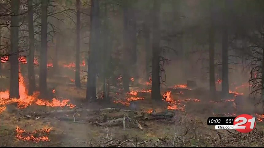
BEDN, Ore. (KTVZ) -- If conditions remain favorable, Bend-Fort Rock Ranger District fuels specialists plan to implement a series of prescribed burns covering nearly 2,500 acres southeast of Bend and southeast of La Pine over the next couple of weeks.
Prescribed burns are critical tools used to reduce potential for large wildfires, remove excess vegetation and improve overall forest health, the Deschutes National Forest said Monday. The Prineville District of the Bureau of Land Management also outlined its fall burning plans.
Depending on the weather, fuels specialists may start ignitions as early as Monday on Maintenance Rx Units 2A and 2B located six miles northwest of the Fort Rock community and about 24 miles southeast of La Pine, near Hole in the Ground.
The units combined total 1,057 acres and ignitions could last up to two days.
Smoke will be visible from Fort Rock and state Highway 31. Visibility along Highway 31 and national forest roads in the area may be temporarily degraded. Residents near Fort Rock and Hole in the Ground may see some smoke impacts.
If conditions continue to remain favorable, fuels specialists may start conducting a 1,400-acre prescribed burn five miles west of Pine Mountain and 20 miles southeast of Bend.
This understory burn encompasses Opine Rx Units 3A, 3C, 1B and 1C and may take up to four days to complete ignitions. Prescribed burning will continue as conditions allow.
Smoke will be visible from Bend and Redmond and along Highway 20 between Horse Ridge and Pine Mountain. Visibility along Highway 20, National forest roads and OHV trails in the area may be impacted.
Temporary OHV trail closures may need to be implemented during operations on the Opine Rx units. Impacted trails may include OHV trails north of the 25 Staging Area and OHV Trails 12, 13 and 18. Forest staff will sign alternative routes of travel.
Hunters, OHV trail users and recreationists traveling in vicinity of both prescribed burns should use caution and adhere to all closures to provide for firefighter and public safety.
Fire management officials work with Oregon Department of Forestry smoke specialists to analyze weather conditions and anticipated smoke dispersion to determine burn dates. When smoke is present, motorists should reduce speed and turn on headlights.
Officials said all efforts will be made to limit smoke impacts to area neighborhoods and communities, but the possibility exists for smoke to settle in low-lying areas, due to cool night-time temperatures. Residents in areas near burn operations are encouraged to close windows at night to avoid possible smoke impacts.
Individuals with respiratory conditions can request to be placed on an advance contact list by calling the Bend-Fort Rock Ranger District at (541) 383-5300.
For prescribed fire information, visit https://www.centraloregonfire.org/what-is-prescribed-fire/when-where-prescribed-fire-smoke/ or follow us on Twitter @CentralORfire.
Here's the BLM release issued Monday morning on its burn plans:
Bureau of Land Management Fall/Winter prescribed burning plan for Prineville District
Bureau of Land Management Ore. & Wash. - 10/26/20 8:39 AM
Prineville, Ore. – As fall weather brings shorter days and cooler temperatures, fuels specialists with the Bureau of Land Management, Prineville District Office are preparing for the fall/winter prescribed burn program. As early as November 1—and continuing through the next few months depending on conditions—specialists will treat a variety of locations with prescribed fire across BLM-managed public lands in Central Oregon. These prescribed burns are planned in the following project areas:
- Cline Buttes: 314 acres of hand pile burning in the Dusty Loop/Innes Market Road area.
- Outback: 358 acres of hand pile burning eight miles southeast of La Pine and on the east side of Highway 31.
- La Pine: 2,692 acres of machine pile burning located in the “Y” between Highway 97 and Highway 31.
- High Desert Shrub Steppe Project: crews will burn juniper slash scattered across 10,000 acres of BLM lands south of Brothers and in the 12-Mile table area east of Paulina, Oregon.
- Williamson Creek: 539 acres of hand pile burning near the corner of Millican Road and Reservoir Rd southwest of Prineville.
The piles are concentrations of leftover materials from previous thinning projects designed to remove hazardous fuels that can burn during wildfires. Juniper removed in the High Desert Shrub Steppe Project have the added benefit of improving Greater Sage-Grouse habitat. Where possible, material was first offered for firewood, commercial sale, or biomass use; with some remaining material scattered to rehabilitate sites and close user-created routes.
The projects are each expected to take several days, and crews will move between each project depending on site-specific weather. Main roads in the area will be signed to inform residents of the prescribed burn and no road closures or delays are expected. Piles may smolder, burn, and produce smoke for several days after ignition. Smoke may settle in overnight, and where necessary, motorists should reduce speeds and turn on headlights.
All prescribed burning is highly dependent on favorable temperature, moisture and wind conditions. Each of these prescribed burns will only be started when the conditions are right to meet the objectives of the burn, while minimizing smoke impacts to any nearby communities. All prescribed burn areas will be patrolled during and following ignitions. Prescribed burns are completed in cooperation with the Oregon Department of Forestry smoke management plan. In addition, fire and fuels managers are working closely this year with air quality and public health authorities on prescribed burns due to COVID-19.
For more information about prescribed burning, please contact the Prineville BLM at (541) 416-6700, or see a complete listing of all the upcoming prescribed burning activities in your area at https://www.blm.gov/programs/public-safety-and-fire/fire-and-aviation/regional-info/oregon-washington/prescribed-fire, or http://www.centraloregonfire.org/
