Numerous large wildfires raging across Oregon; here’s latest updates on several of the biggest
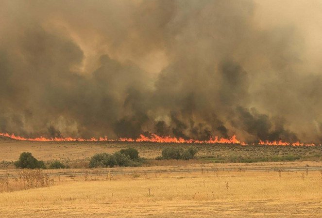
CONDON, Ore. (KTVZ) -- Here's Wednesday's official updates on several of the large fires burning across Oregon:
LONE ROCK FIRE UPDATE July 24, 2024
Location: Lonerock, Oregon to west of Highway 207| Size: 134,752 acres | Containment: 40% | Cause: Under Investigation | Start Date: July 13, 2024 | Total Personnel: 1,031
InciWeb: https://inciweb.wildfire.gov/incident-information/orprd-lone-rock-fire
Fire Information Line: 541-208-4369 | Email: 2024.0404rvlonerock@firenet.gov
Condon, Ore. — The Lone Rock Fire is being managed under a full suppression strategy by the unified command of the Northwest (NW) Team 2 and Oregon State Fire Marshal (OSFM) Red Team.
Yesterday’s Activities: Firefighters worked through the day along the eastern side of the fire perimeter to build control lines from Burton Hill to the south. The steep terrain between Forest Service Road (FSR) 21 and FSR 25 continued to pose challenges for control. Crews used existing dozer line and water tenders to suppress fire activity in this area. Night crews continued these suppression tactics by beginning to construct a hose lay along the fireline. Additionally, indirect dozer line is being used as a contingency. South of FSR 25 crews continued to secure the fireline with direct and indirect line and begin mop-up activities where fire behavior allowed.
Crews and OSFM structural task forces carried out firing operations and structure protection on the southern portion of the fire. While fire activity did increase with the addition of fire on the landscape, crews were successful in holding the line with minimal spotting. Where fire did extend beyond the planned control lines, firefighters were quick to secure and contain any minimal spot fires.
On the northern portion of the fire, crews continued to patrol the fireline with no change in fire activity in the area with 40 percent containment.
Strategic aerial firefighting plays a critical role in firefighting effort when supported by firefighters on the ground. Aerial supervision provides birds-eye identification of hot spots and coordinates where to send helicopters equipped for suppression and is needed when there are multiple aviation assets in the air. Use of aircraft for strategic aerial firefighting is constantly evolving based on resource availability, weather, and smoke conditions.
Strategic aviation resources were also used in aerial ignition with a plastic sphere dispenser (PSD) on Tuesday. The PSD allowed firefighters ease in connecting large areas of unburned fuels that threated to extend beyond the western edge of the fire along FSR 25. Task forces conducted structure assessment of areas to the west of FSR 25 and crews identified a small spot to the west of Notch Road. Crews worked through the evening to build line around this spot to reduce further growth.
OSFM structural task forces worked with their wildland partners to hold Highway 19 and support firing operations. Crews were also able to access areas of the fire that previously burned to begin damage assessments. During their initial assessments, OSFM resources identified three primary residences that were destroyed by the fire. Assessments will continue as firefighters are able to get into more areas, some additional structure damage may be found. An additional structural task force from Marion County arrived, bringing the total number of OSFM structural task forces to 13.
Today’s Activities:
Patrols and mop-up activities to maintain the existing fire perimeter will continue today in anticipation of some incoming weather. There is a Red Flag Warning in effect from 12:00 p.m. through 11:00 p.m. this evening for abundant lightning for fire weather zones. Thunderstorms in the afternoon and evening hours to the southeast of the fire perimeter may bring strong winds, lightening, and overall instability to the fire area. Shifting winds patterns, particularly in the tight canyons and draws, may test containment lines.
The focus for much of the uncontained fire perimeter will be on holding the existing line, connecting control line, and prepping unburned areas. Sprinkler line will continue to be installed on the fire’s western perimeter between FSR 21 and FSR 25 for holding where terrain allows. Similarly, crews along the south and southwest of the fire perimeter will focus efforts on mop-up and holding.
Crews along Alder Creek and near the western side of FSR 25 will continue to hold heat built during firing operations to control fire activity along highway 19 to the south and FSR 25 along the western fire perimeter. Crews will continue to build containment line and secure the spot near Notch Road using direct dozer line. OSFM task forces will be focused on prepping and mopping up around structures along Winlock Road. Structural task forces will also work to access more homes within the fire perimeter to complete damage assessments.
Evacuations:
- Level-3 Evacuations – GO NOW! Level-3 Evacuate immediately for the following areas:
- Gilliam County: residences South of Lonerock. For more information on evacuations, visit Gilliam County Sheriff’s Office Facebook page.
- Wheeler County: highway 19 at Rowe Creek Road, south on Rowe Creek Road to Twickenham Bridge, to highway 19 at Girds Creek, east to the county line, north of the county line to Morrow County line, west on the northern county line, south through the Kinzua area, south back to Rowe Creek Road. For more information on evacuations, visit Wheeler County Sheriff’s Office Facebook page.
- Morrow County: from the west County Line along Buttermilk Canyon to highway 207, Mile Post 10 south of Hardman to the south Morrow County line. East of Highway 207 and south of FSR 21 to the eastern county line. For more information on evacuations, visit Morrow County Sheriff’s Office Facebook page.
- Level-2 Emergency Alert – GET SET! Level-2 Be set to evacuate at a moment’s notice for the following areas:
- Gilliam County: residences north of Lonerock. For more information on evacuations, visit Gilliam County Sheriff’s Office Facebook page.
- Wheeler County: HIGHWAY19/Rowe Creek to Twickenham then Girds Creek/HIGHWAY 207 S, south on HIGHWAY 207 to Cherry Lane west to the Grant County line. For more information on evacuations, visit Wheeler County Sheriff’s Office Facebook page
Shelters:
- An evacuation center has been set up at the Wheeler High School (600 E B Street, Fossil, Ore.). A large animal shelter is available at the County Fairgrounds (720 E 3rd Street in Fossil, Ore.).
Closures:
- OR-19 is closed all hours of the day between milepost 78.7 to milepost 95.2. OR-207 is closed between the hours of 8:00 a.m. and 8:00 p.m. to provide for firefighter and traveler safety with active equipment and fire activity to the west of the highway. For updated road closure information, visit https://www.tripcheck.com/.
- Umatilla National Forest Order Number 06-14-02-24-01 affects all National Forest System lands, trails, and roads that lay within the Proclamation Boundaries of the Umatilla National Forest and reside within Wheeler County.
- Umatilla National Forest Order Number 06-14-02-24-02 includes prohibitions within the Heppner Ranger District on the Umatilla National Forest.
- Bureau of Land Management Prineville District Office issued an Emergency Public Land Closure on BLM-managed lands along the main stem John Day River from Kimberly, Ore. To Dale, Ore.; and along the North Fork John Day River from Kimberly, Ore. to Dale, Ore.
Weather: The National Weather Service in Pendleton has issued a Red Flag Warning for abundant lightning, which is in effect from 12:00 p.m today through 11:00 p.m. Passing thunderstorms will bring strong, erratic winds, small hail, and abundant lightning. There is no longer a Fire Weather Watch; however, fire activity could be accelerated with the incoming winds. Winds are anticipated from the south and southeast with maximum ridgetop speeds of 45 to 60 mph this evening.
Smoke Information: Visit https://fire.airnow.gov/ for local air quality information.
Flight Restrictions: A Temporary Flight Restriction (TFR) is in place above the Lone Rock Fire area. If you fly, we can’t. Unauthorized drone flights (UAS) pose serious risks to firefighter and public safety and the effectiveness of wildfire suppression operations. Aerial firefighting is suspended when unauthorized UAS are in the area, allowing wildfires to grow larger.
--
Durkee, Cow Valley, and Bonita Fires Update for Wednesday, July 24, 2024
541-208-4371, staffed 7AM to 7PM PDT
DURKEE FIRE: Start date: July 17, 2024 | Location: 5 miles southwest of Durkee, OR | Personnel: 526 | OSFM Task Forces: 4 | Fire size: 244,858 acres | Cause: Lightning | Containment: 0%
Today’s weather will lead to extreme fire behavior and growth. A Red Flag Warning has been issued for severe thunderstorms and will be followed by a Flash Flood Watch. Thunderstorm wind gusts may reach 75 mph and are expected to directly impact the Durkee Fire footprint. Burned areas are more susceptible to landslides, mudslides, flash floods and debris flow. The amount of rainfall is not known at this time, but 15/100 of an inch of precipitation in 15 minutes could be enough to cause debris flows.
The Malheur County Sheriff’s Office and the Baker County Sheriff’s Office have issued evacuations for multiple areas. Residents in Level 3 Evacuations “GO NOW”, should leave immediately. Residents should not return to their property until evacuation levels have been removed. Carry enough supplies to support you and your family for multiple days. A real time map of fire evacuations can be found at the State of Oregon Fire Dashboard.
Weather and fire behavior could impact transportation, power transmission, cell service and other utilities. Monitor these resources for additional information.
- Oregon Department of Transportation - TripCheck.com
- Idaho Power - IdahoPower.com
- American Red Cross of Eastern Oregon and Idaho - https://www.redcross.org/local/idaho.html
The Durkee Fire is located west of Interstate 84 (I-84). The Thompson Fire, a convergence of lightning fires that started near Thompson Creek on July 22, is located east of I-84. Both have grown rapidly with the persistent high temperatures, strong winds, and extremely dry fuels.
Firefighters worked overnight to maintain primary and secondary firelines and to support structure protection. No strategic firing operations were initiated. Today, wildland firefighters are anticipating the extreme weather event. They will remain strategically placed around the fire area for when the extreme weather arrives and engage when safe to do so. Protecting life of the public and firefighters is the highest priority of the incident.
Oregon State Fire Marshal task forces will work to support communities around the fire perimeter.
Yesterday, air resources were limited due to poor visibility and high winds. Air resources are expected to be limited or grounded today due extreme weather.
WEATHER AND SMOKE:
- RED FLAG WARNING
- FLASH FLOOD WATCH
- Thunderstorms with outflow winds as high as 75 mph
- For current smoke information, visit airfire.org.
EVACUATIONS AND CLOSURES:
The Malheur County Sheriff’s has issued evacuations for the area around Durkee Fire. check for updates on the Malheur County Sheriff’s Office Facebook page. There is an American Red Cross shelter in Ontario at the Malheur County Fairgrounds, 795 N.W. 9th Street.
The Baker County Sheriff’s Office has issued evacuations for the area around Durkee Fire. Visit the Baker County Sheriff’s Office Facebook page for more information. Baker County Sheriff's Office has closed Burnt River Canyon Road to non-local, non-emergency traffic due to the Durkee Fire.
I-84 AND OTHER HIGHWAYS: Please go to tripcheck.com for current road closures as the situation is dynamic and subject to change.
BURN BAN: A burn ban is currently in effect for all of Malheur County, including all BLM lands. For more information, visit https://www.malheurco.org/category/public-notices/.
TEMPORARY FLIGHT RESTRICTION: There is a temporary flight restriction over the Durkee Fire, please remember, if you fly we can’t! If a drone or other aircraft enters the air space, all firefighting aviation equipment will be grounded.
COW VALLEY FIRE: Start date: July 11, 2024 | Location: 9 miles east of Ironside, OR | Personnel:
0 | Fire size: 133,490 acres | Cause: Human caused |Containment: 91%
BONITA FIRE: Start date: July 11, 2024 | Location: 9 miles south east of Ironside, OR | Personnel: 0 | Fire size: 2,727 acres | Cause: Human caused |Containment: 90%
Durkee and Cow Valley Facebook Page
--
Weather expected to challenge firefighters Wednesday, Oregon State Fire Marshal resources work to protect threatened communities
Oregon State Fire Marshal - 07/24/24 12:07 PM
SALEM, Ore. – Over the last week, firefighters have been challenged by hot temperatures and gusty winds that continue to push several wildfires across the state. The Oregon State Fire Marshal is calling on all Oregonians and visitors to be aware of the critical fire danger and take steps to prevent sparking a wildfire. The eastern side of the state is expecting abundant lightning, winds gusting near 60 miles per hour with passing thunderstorms, and hot temperatures.
“We are working with every tool we have to protect people and property,” Oregon State Fire Marshal Mariana Ruiz-Temple said. “The Oregon structural fire service, our out-of-state firefighters, and our wildland partners are working relentlessly around the clock. I want to say thank you. This is a monumental challenge that every firefighter and support staff is rising to.”
The structural fire service response has been immense. The OSFM has mobilized 489 firefighters, roughly 143 engines, and 32 water tenders to protect communities across the state.
The OSFM has resources assigned to:
- Lone Rock/Boneyard Fire (Gilliam, Morrow, Grant, and Wheeler counties)
- Falls Fire (Harney and Grant counties)
- Durkee Fire (Baker and Malheur counties)
- Battle Mountain Complex (Grant and Umatilla counties)
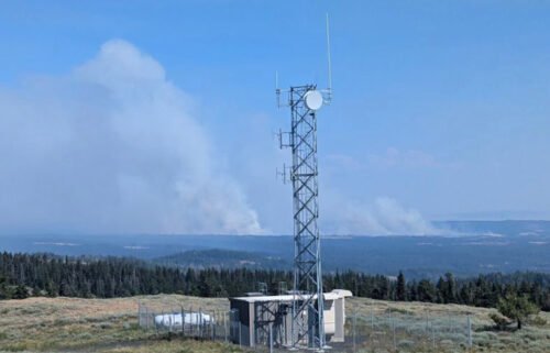
- Microwave Tower Fire (Wasco County)
The OSFM is continually monitoring capacity within the Oregon Fire Mutual Aid System and is in contact with out-of-state partners to be ready to respond to new fires if resources are needed. When communities are threatened by wildfire, the Oregon State Fire Marshal provides structural protection resources and support. While the agency focuses on protecting people and property, it works in lockstep with wildland partners from the Oregon Department of Forestry, the Bureau of Land Management, tribal agencies, and the U.S. Forest Service.
Roughly 90 people are a part of the OSFM’s three incident management teams currently mobilized. Since July 9, the Emergency Conflagration Act was invoked seven times.
On Sunday, the Emergency Conflagration Act was invoked for the Battle Mountain Complex in Grant and Umatilla counties. The move by Governor Tina Kotek allowed the OSFM to send firefighters and equipment to protect nearby communities.
For updates on the fires the OSFM has resources assigned to, visit www.osfminfo.org. Learn more about wildfire prevention here.
Information Resources
- Lone Rock/Boneyard: InciWeb
- Falls Fire: Facebook, InciWeb
- Durkee Fire: Facebook, InciWeb
- Battle Mountain Complex: Facebook, InciWeb
--
Boneyard and Courtrock Fires Daily Update 07-24-2024
Good Progress on the Boneyard Fire Near Monument, Courtrock Fire Nearly Lined Overnight Ahead of Predicted Wednesday Thunderstorms
MONUMENT, Ore. – Firefighters were able to make good progress overnight, completing bulldozer and handline on the southern portion of the Boneyard Fire closest to the town of Monument, as well as bulldozer line around the majority of the Courtrock Fire. This work is extremely important ahead of Wednesday’s day shift, with conditions once again expected to work against firefighters.
Overnight, the National Weather Service issued Red Flag Warning for the southeast portion of the Boneyard Fire and all of Courtrock due to expected thunderstorms with strong winds and abundant lightning. This goes into effect at noon on Wednesday, and ends at 11 p.m. Winds may be erratic and are expected to influence fire behavior; firefighters are aware and prepared for the potential increase in fire activity and will respond to any new lightning-caused fire starts nearby.
Today, resources on the Courtrock Fire will be working to complete the last few portions of line, which will stop the fire’s growth. On the Boneyard Fire, work continues north and west of Monument, with line-strengthening. Fire hose will be constructed in these areas today to allow for better access to water. On the northwestern portion, much of the same work is continuing.
To the northeast side, resources are engaged. On the southeast side, firefighters continue to build on line that has been established; a lot of work in these areas is providing protection to homes in the area. To the east, the Boneyard Fire continues to be on the path of merging with the Monkey Creek Fire; Team 1 is coordinating with ODF Team 3, assigned to that incident, as these fires close in on each other.
For Wednesday’s day shift, 490 personnel are assigned to the Boneyard and Courtrock Fires, including 14 20-person crews, 13 bulldozers, seven tree fallers, eight water tenders and 24 engines, including three structural task forces from the Oregon State Fire Marshal (OSFM). Another task force from OSFM will be arriving later today, along with additional resources ordered by Team 1 that will be strategically placed on the fire line. For aircraft, one Type one, one Type 3 and two Type 2 helicopters are assigned to the fire, and they will be used as soon as visibility increases.
Closures: The Bureau of Land Management has closed public lands along the John Day River from Kimberly to Dale, and from Kimberly to Service Creek. More information here: https://www.blm.gov/programs/public-safety-and-fire/fire-and-aviation/regional-info/oregon-washington/fire-restrictions.
Closures continued: The Umatilla National Forest has implemented a closure for public lands within the Heppner Ranger District. More information here: https://www.fs.usda.gov/detail/umatilla/news-events/?cid=FSEPRD1194462.
Evacuations: Level 1 (Get Ready), Level 2 (Be Set) and Level 3 (Go Now) evacuations are in effect. For updated evacuation information:
- Grant County Emergency Management Office’s Facebook page, https://www.facebook.com/profile.php?id=100068819321423, or sign up for the Grant County Emergency Alert System at https://member.everbridge.net/825462649520134/login.
- Morrow County Evacuation information can be found at https://experience.arcgis.com/experience/de78333b0d2544f7a3 20142174aa20ae
Shelters: An evacuation center has been set up at Grant Union High School (911 S Canyon Blvd., John Day, OR 97845).
--
Falls and Telephone Fires Update for July 24, 2024
Falls Fire Quick Facts:
Size: 140,422 Start Date: July 10, 2024 Location: 13 Miles NW of Burns, OR
Containment: 50% Total Personnel: 1,621 Cause: Human-caused, under investigation
Structures Triaged: Residences: 347; Commercial: 104; Outbuildings: 605
Resources Assigned: 49 hand crews, 94 engines, 23 bulldozers, 29 water tenders
Aerial resources available to the fire: two helicopters, and single-engine air tankers (SEATS)
Telephone Fire Quick Facts:
Size: 9,000 Start Date: July 22, 2024 Location: 12 miles NE of Burns, OR
Containment: 0% Total Personnel: Staffed by Falls Fire personnel Cause: Lightning/Natural
*See Falls Fire Quick Facts for additional information on total resources assigned and structures triaged combined.
Telephone Fire: The Telephone Fire started Monday, July 22, south of King Mountain on the Emigrant Creek Ranger District on the Malheur National Forest. The fire perimeter is approximately five miles east of Highway (Hwy) 395 and fourteen miles north of Hwy 20. Yesterday’s operations focused on establishing control lines around the fire and conducting tactical burnout operations intended to harden and secure control lines around the fire. Control lines included using FSR 28 on the eastern flank and tying a system of roads to the north and west, including FSR 480 and FSR 2020, over to FRS 28. Crews and dozers also worked in coordination to establish control lines along the southern perimeter of the fire. Oregon State Fire Marshal (OSFM) resources have pivoted to assist with the Telephone Fire. These crews continue to identify and complete surface prep on homes north of Hwy 20 and along the drainages including Reed, Harney, King Mountain, Rattlesnake Road/FSR 28, and surrounding areas.
Today, crews will continue to construct control lines around the fire and then strengthen and hold them. Aerial resources will be available to help with suppression operations.
Falls Fire: Containment lines continued to hold along southern portions of the fire perimeter. Increased containment along the southern flank has allowed resources to be re-directed to more active areas of the fire. These areas include the upper northeast corner, near FSR 68 and FS 47, the areas in and adjacent to the community of Izee; the northern flank near the Gilbert Ridge area; and the upper southeast corner near the Myrtle Park Meadows and Gold Hill area.
In the northwest corner of the fire, firefighters continued to hold and mop-up line below the western slopes of Burnt Mountain along FSR 4785 near Coral Creek south and east to FSR 47 near the junction with FSR 3150. Construction of secondary contingency (backup) dozer line has been completed to the northwest near Snow Mountain along FSR 4781 and also north and south off FSR 4781 in the Snow Mountain area. Crews continued to connect fireline back into FSR 3150 in the northeast corner of the fire. The road will be used as an anchor for conducting tactical burnouts. In the northeast corner, crews continue to hold and mop-up established control lines. Work will also continue further east on the 3150 preparing it to use as a control line, including using it as an anchor for conducting tactical burnouts. Firefighters will scout for additional opportunities to establish a continuous secondary control line running east to west, north of the fire. In the northwest corner, crews will continue to hold and mop-up established control lines. Yesterday, the majority of OSFM Task Forces remained in patrol status for a second day in the Izee and Red Hill areas. Reports from these crews are positive, noting a reduced threat to structures in these areas. Two OSFM engines will remain assigned to these areas to patrol and monitor fire line near structures.
The northeast corner of the fire remains active. Firefighters will continue to hold and mop up areas adjacent to the FSR 31 south of Myrtle Park Meadows, and work on tying the fire back into the FSR 31. In the northwest corner of the fire, firefighters continued to hold and mop-up line below the western slopes of Burnt Mountain along FSR 4785 near Coral Creek south and east to FSR 47 near the junction with FSR 3150. Structural and wildland crews are coordinating to protect structures and mitigate risk to the Gold Hill and Silvies Valley areas. There are structural crews in placed along the Hwy 395 corridor, providing protection to structures on both the east and west sides of the highway.
Patrol and mop-up operations will continue along the south half of the fire perimeter – the area spanning from the southwest perimeter of the fire to near the upper northwest perimeter. One structure engine will patrol the Red Hill area. Further north, away from the fire perimeter, construction will continue on a planned secondary contingency line along FSR 37 just west of Hwy 395 in the Fisk Gulch area. This secondary contingency line is part of an alternate plan and will run east to west using portions of FSR 37 and FSR 31.
Thanks to the combined efforts of OSFM and wildland resources, the structural threat has gradually declined in stable areas of the Falls Fire. However, the threat remains present in portions of both the Falls and Telephone Fires. Structural protection needs will continue to be evaluated daily and resources will be shifted in alignment with the incident needs.
Weather: Extreme fire weather is predicted for today. A cold front will move over the fire today which will bring gusty westerly winds, thunder and rain. General winds will be the strongest that the fire has seen so far. Winds will peal after 3 PM. Thunderstorm chances are highest between 2-4 PM. Outflow winds from thunderstorms could reach 50 mph. These thunderstorms appear to be wet enough to cause debris flow-style flash flooding. There is a 30% chance of wetting rain. Temperatures will range between 85-92 degrees.
Evacuations: Evacuations remain in place in both Grant and Harney Counties due to the Falls and Telephone Fires. For the most accurate evacuation information, please visit the Harney County Sheriff’s evacuation map here: https://tinyurl.com/3zst4sjy, or the Grant County Emergency Management Facebook page at: https://www.facebook.com/profile.php?id=100068819321423.
Closures: Due to active wildfires compounded by extremely unfavorable weather conditions, limited firefighting resources and County Resources, Malheur National Forest officials are temporarily closing lands within the Malheur National Forest. This closure means that the public is prohibited from entering lands, roads, trails and recreation areas, and facilities on the Malheur National Forest. A detailed map and description of the closure area is available on the Forest website and at any Forest office. Closure signs will be posted on the ground.
Investigation: U.S. Forest Service fire investigators are seeking the public’s assistance with any tips or information pertinent to the start of the Falls Fire on the Malheur National Forest. Please submit any information that could assist fire investigation efforts to SM.FS.R6TipHotLine@usda.gov.
Facebook: https://www.facebook.com/p/Falls-Fire-2024-61562126623985/
Falls Fire InciWeb: https://inciweb.wildfire.gov/incident-information/ormaf-falls-fire
Telephone Fire InciWeb: https://inciweb.wildfire.gov/incident-information/ormaf-telephone-fire
Fire Information Line: 541-208-4370, staffed 8 a.m. to 8 p.m.
Email: 2024.Falls@firenet.gov
Harney County non-emergency evacuation questions: 541-589-5579
Air quality questions: 541-573-2271
Smoke Outlooks: https://outlooks.airfire.org/outlook
Related Links:
--
Ore Fire Update
Wednesday, July 24, 2024 – 9:30 a.m.
Size: 860 acres | Reported Date: July 16, 2024 | Cause: Under Investigation
Total Assigned Personnel: 301 | 8 engines | 4 hand crews | 3 dozers | 18 water tenders | 4 masticators | 4 feller bunchers
(Blue River, Ore.) – Fire suppression efforts continue on the Ore Fire, which is burning 7 miles northeast of Blue River, Oregon. Challenges include steep and rugged terrain, falling rocks and rolling debris, fire-weakened trees, and extreme weather conditions. Firefighter and public safety remain the number one priority on the incident. Fire managers are focusing on activities with a high probability of success while minimizing risk to firefighters while protecting values such as communities, infrastructure and forest, recreation and cultural resources.
Last night’s community meeting in Blue River was well attended and the Northwest Complex Incident Management Team 10 expresses its appreciation for the community’s support and engagement.
Yesterday, burning debris rolling down the steep slopes caused fire to slopover (cross) the control line at the FS 1509 Road about a mile from the FS 15 Road junction. Ground crews, assisted by aviation resources, secured this slopover, but falling debris will remain a challenge in the southwest portion where the fire is most active. An engine patrolled and monitored through the night. Road grading was completed along the FS 1509 Road, north of Tidbits Trailhead. Firefighters successfully held the fire at the FS 15 Road, and heat is diminishing along the established control line.
Today, crews will monitor the slopover, and patrol the rest of the southwest line as the fire continues backing down to FS 1509. Feller bunchers and masticators will follow the road grading operations above Tidbits Trailhead to strengthen the FS 1509 Road. Northeast of the fire, grading operations will begin along the FS 1513 Road.
Weather: Occasional shading from passing clouds will trend temperatures a few degrees cooler and moderate humidity today compared to yesterday. Terrain-driven winds continue for the next few days. A deep marine layer will push onshore tonight, bringing mostly cloudy skies, warmer overnight low temperatures, and excellent humidity recovery.
Safety: Fire danger continues to increase as does the number of fire incidents around the region. The public plays a crucial role in preventing the next wildfire. Your caution with all ignition sources can help avoid causing undue strain on firefighting resources. For prevention tips, visit https://keeporegongreen.org. Fire restrictions are in place within the Willamette National Forest. For more information visit https://www.fs.usda.gov/main/willamette/fire. A Temporary Flight Restriction (TFR) is in place over the fire area.
Smoke: Smoke from numerous wildfires burning throughout the state will affect air quality in many areas over the coming days. An Air Resource Advisor is now assigned to the Ore Fire and providing daily smoke outlooks for the affected area at https://wildlandfiresmoke.net. Being prepared for smoke is important to everyone’s health. For more information go to: www.airnow.gov/wildfires/be-smoke-ready.org/
Forest Closures: Closures in the Willamette National Forest have been established around fire-impacted areas. These closures include the following sites: Buck Mountain Trail, Tidbits South and West Trail, Gold Hill Trail, Mona Campground, Lookout Campground, and Saddle Dam Boat Launch. For a complete list of recreation and roads in the Ore Fire closure order, visit https://www.fs.usda.gov/alerts/willamette/alerts-notices.
--
RED FIRE UPDATE
July 24, 2024
Fire Information Line - 541-316-7711
centraloregonfire.org x.com/CentralORFire
Inciweb: https://inciweb.wildfire.gov/incident-news/ordef-red-fire
Size: 292 acres | Location: 5 miles west of Crescent Lake Junction, Oregon
County: Klamath | Start Date: July 17, 2024 | Containment: 0% | Cause: Lightning
Total Personnel: 156
Klamath County, Oregon — The Red Fire is located within the Diamond Peak Wilderness on the Deschutes National Forest, on the southwest slope of Redtop Mountain. The fire is being managed under a full suppression strategy. The Southern Area Gray Incident Management Team, led by Incident Commander Fulton Jeansonne, assumed command of the fire on Friday, July 19, at 6:00 a.m. local time. Public and firefighter safety is the highest priority in managing this fire.
The Diamond Peak Wilderness encompasses 52,500 rugged acres straddling the crest of the Cascade Mountains. It was designated in 1964 by the Wilderness Act, to be stewarded in its natural, undeveloped condition. Motorized equipment, motor vehicles, and aircraft are prohibited in Wilderness by federal law, with narrow criteria for exceptions. The USDA Forest Service has authorized the use of chain saws, portable pumps, fire retardant, and aircraft landings by firefighters on the Red Fire since initial attack.
A Red Fire Community Meeting was held on Monday July 22. A recording is available here.
Yesterday’s Activities – Firefighters continued to assess and scout opportunities for control features within the Wilderness. Construction of the shaded fuel break continued southwest of the Crescent Lake Junction community; along the west side of the Union Pacific Railroad tracks to the north, and along the north side of Forest Road 60 near Crescent Lake working southwest.
Today’s Activities – Firefighters will continue to assess and scout opportunities for control features near the current fire footprint within the Wilderness. Additional heavy equipment resources continue to arrive and, along with hand crews, resources will continue the construction of the shaded fuel break along the west side of the Union Pacific Railroad tracks and the north side of Forest Road 60, southwest of the community of Crescent Lake Junction. Shaded fuel breaks thin dense tree stands to reduce a fire’s intensity while retaining enough shade to slow down ground fire.
Heavy equipment working on the shaded fuel break along Forest Road 60 will cause periodic temporary traffic stoppages. The public is encouraged to avoid travel on Forest Road 60 if possible. In anticipation of a future forest closure for the area, the public is discouraged from recreating in the Crescent Lake area.
Weather – Mostly sunny today with haze throughout the day. Temperature 76-79 degrees, humidity 31-36 percent. Light terrain driven winds in the morning will become west winds 10-12 mph in the afternoon, with evening gusts to 23 mph. Overnight temperature will decrease to near 45 degrees, with humidity near 80 percent.
Evacuation Notice – The “WILDFIRE! Level 1 – BE READY to Evacuate” notice issued by Klamath County Emergency Management for the Crescent Lake, Odell Lake, and Crescent Junction area remains in effect. For information, or to sign up for alerts, visit: https://www.klamathcounty.org/300/emergency-management
Klamath County Emergency Management. INCENDIO FORESTAL! Nivel 1 - ESTÉ PREPARADO para evacuar de las siguientes zonas: Crescent Lake, Odell Lake, Crescent Junction.
Red Fire Area Closures – An area emergency closure is in effect for the entire Diamond Peak Wilderness due to the Red Fire. For more information, visit the Deschutes National Forest website at: https://www.fs.usda.gov/alerts/deschutes/alerts-notices/?aid=89091
Fire Restrictions – Public use fire restrictions are currently in effect for the Deschutes National Forest. Visit CentralOregonFire.org or the Deschutes National Forest’s website (fs.usda.gov/detail/deschutes/home/?cid=stelprdb5297376) for more information.
Smoke from the Red Fire and other area fires will continue to impact air quality. Air quality information can be found at https://fire.airnow.gov/.
A Temporary Flight Restriction is in place over the fire area. If you fly, we can’t. Unauthorized drone flights (UAS) pose serious risks to firefighter and public safety and the effectiveness of wildfire suppression operations. Aerial firefighting is suspended when unauthorized UAS are in the area, allowing wildfires to grow larger.