More heat, wind bring new C.O. wildfires, while others grow larger

(Update: Wednesday night update on region fires )
Lily Lake fire area closure; crews tackle 2 new fires, fight continue on others
CAMP SHERMAN, Ore. (KTVZ) – More heat and winds increased fire behavior around the region on Wednesday, with several small fires growing much larger and other new ones being tackled.
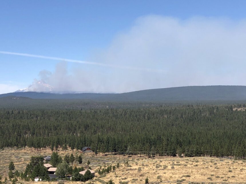
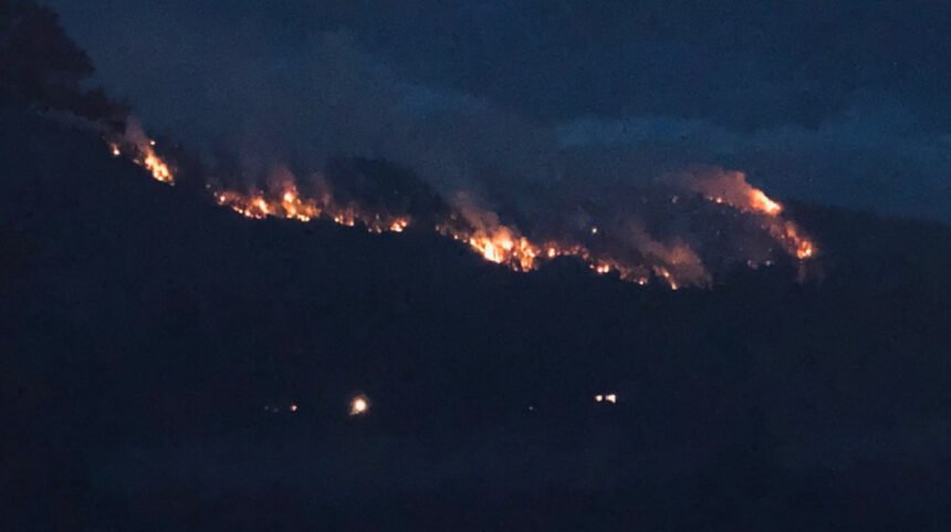
The Deschutes and Jefferson County sheriffs issued Level 2 (Be Set) evacuation notices Wednesday for homes north of Indian Ford Road and Level 1 (Be Ready) notices to the south in the Camp Sherman area after the Green Ridge Fire doubled in size, to over 1,000 acres.
The Green Ridge Fire was burning on the Deschutes National Forest and private land protected by the Oregon Department of Forestry.
A Type 2 Incident Management Team has taken command of the fire and the Deschutes and Jefferson County Sheriff’s Offices issued a joint notice for evacuation levels on the Green Ridge Fire. Information for the Green Ridge Fire can be found at: https://inciweb.nwcg.gov/incident/7012/
Janet Morningstar, who was visiting from the Portland area to go camping, described the spectacle as the fire grew Tuesday night: "Last night, when we were walking out here, the fires looked as though it was a city on a hill -- there were just lights and fires everywhere."
Deschutes County Sheriff's Search and Rescue volunteers were going door-to-door Wednesday in the Indian Ford Road and Stevens Canyon Road area to assist in notifying residents of the alerts and to prepare in case they have to lave, sheriff's Lt. Bryan Husband said.
Gary Gustafson, who owns a home in the area, talked of his worries Wednesday, but also his confidence in the professional firefighters on the job.
"Well, you always get nervous -- but I have a lot of faith in our firefighters," he said. "They’ve proven themselves time and again, so if it’s humanly possible they’ll do everything to protect us."
In an update Wednesday night, Frontier 911 (Jefferson County) dispatch said the Camp Sherman basin remained in a Level 1 "Be Ready" pre-evacuation notice.
They also said the fire was "not causing any closures in the 3 Rivers community or areas surrounding Lake Billy Chinook and remain open." Fire chiefs and the sheriff's office were keeping "in constant communication with firefighting teams," the added.
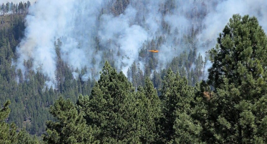
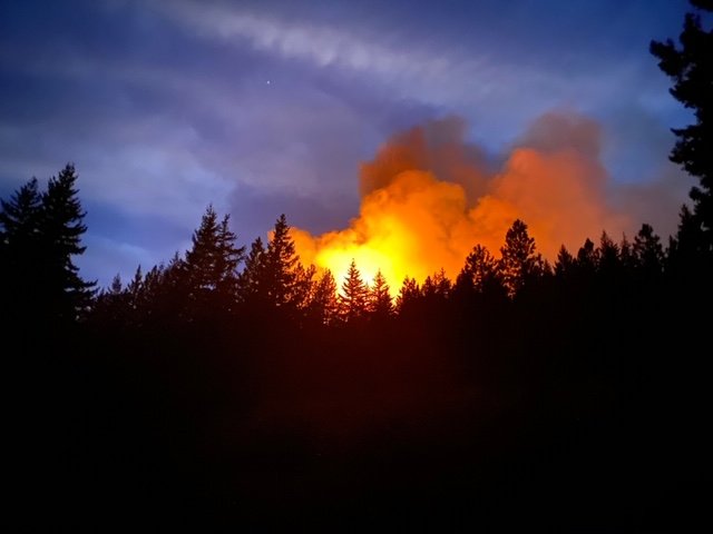
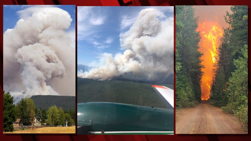
The Frog Fire, in the Maury Mountains of the Ochoco National Forest east of Prineville, also became very active Wednesday afternoon, with a visible column from surrounding areas, including Prineville.
By Wednesday night, it was estimated to be 530 acres, with no containment. The fire made a significant push to the east and south Wednesday, and officials said an area closure will be put in place on Thursday for the safety of the public and firefighters working in the area. A Type 2 Incident Management Team will take command of the fire on Friday.
The Lily Fire on the Deschutes National Forest was estimated to be 37 acres and 25% contained late Wednesday.
Smokejumpers and crews are challenged by working to suppress the fire, burning in the 1996 Charlton Fire scar with a significant amount of downed wood. The fire is burning in heavy timber, and firefighters were assisted by aerial resources cooling hot spots while they continued to build containment lines Wednesday. An area closure has been put in place for this fire: https://www.fs.usda.gov/alerts/deschutes/alerts-notices
One new blaze, the Laurel Fire, was burning on private land and Prineville District Bureau of Land Management land about 7 miles northwest of Kimberly. Wheeler County Fire and Rescue, along with firefighters from the BLM and US Forest Service, worked the 1,000-acre fire Wednesday, along with single-engine air tankers. Crews were continuing the work of establishing preliminary containment lines Wednesday night.
Another new fire, the Hog Ridge Fire, burned 18 miles northwest of Dayville and north of Highway 26 near milepost 90, and was estimated at 350 acres. Air tankers assisted crews and a bulldozer to construct line, and by the end of the day, fire behavior had moderated. Firefighters intend to continue holding and improving containment lines Thursday.
Additionally, firefighters responded to numerous initial-attack incidents Wednesday, including the Peewee Creek Fire, which was held at 12 acres. Firefighters will continue to hold, improve and mop-up containment lines Thursday.
Here's the update on the Green Ridge Fire issued Wednesday afternoon by the new incident management team:
Agency Jurisdiction: Oregon Department of Forestry/USFS-Deschutes National Forest
Email: 2020.GreenRidge@firenet.gov
Twitter: @CentralORfire
Green Ridge Fire Information: https://inciweb.nwcg.gov/incident/7012/
Central Oregon Fire Information: www.centraloregonfire.org
| Date Started: August 16, 2020 | Acres: estimated at 1,013 acres |
| Cause: Lightning | Containment: 0% containment |
Jefferson County, Oregon – The Green Ridge fire started on August 16 approximately 12 miles northwest of Sisters, Oregon. The Central Oregon Fire Management Services Team (COFMS), a local Type 3 Team, has been managing initial attack operations since the fire began. The fire continues to burn in mixed conifers and sagebrush. High temperatures and afternoon winds yesterday caused spotting across the eastern edge of the fire, and the fire grew to approximately 1,013 acres.
At 6:00 a.m. today, an Interagency Incident Management Team (NW Team 10) from the Pacific Northwest (Alan Lawson, Incident Commander) assumed management of the fire.
Fire operations will focus on scouting for line locations and begin construction of direct and indirect fire line. Suppression priorities include stopping the spread of the fire into private timberland to the east and establishing and holding containment lines on the west where the fire has backed down into the Metolius Basin.
More than 170 firefighting personnel are assigned to the Green Ridge Fire. Challenges remain high temperatures and low relative humidity, afternoon winds, and steep slopes on the western edge of the fire.
Three helicopters are assigned to the Green Ridge Fire. With limited flight time each day, these resources are used to support ground resources during the most critical time of the day when the fire is most active. A temporary flight restriction (TFR) is in place over the Green Ridge Fire area, restricting public access for aircraft including drones. Any time a drone is sighted within the TFR, air operations are grounded.
Our highest priority is the safety of the public and all wildland fire personnel. In coordination with local partners, state and federal fire agencies, the Wildland Fire Response Plan (WFRP) was developed to help protect firefighters and the public during the COVID-19 pandemic. To keep firefighters and communities healthy and safe during the Green Ridge Fire, all fire personnel are expected to follow recommendations from the Centers for Disease Control and Prevention (CDC). This includes limiting public access to the Incident Command Post (ICP) at Sisters Middle School. While COVID-19 circumstances are rapidly evolving, and federal agency guidance continues to adapt with the situation, NW Team 10 is prepared for wildland fire activity during this time.
The Deschutes National Forest is establishing area and road closures for the Green Ridge Fire today and a map and description of the closure area will be posted to Inciweb as soon as it is available.
Announcement from the Pet Evacuation Team:
The Pet Evacuation Team is prepared to set up at the Sisters Rodeo Grounds if Level 3 evacuations are called for the Green Ridge Fire.If assistance is needed with evacuees animals, they may call 541-610-6628. If people are wanting to offer help, we ask that they email us at info@PetEvacuationteam.com, rather than calling us. Thank you.
Here's the joint news release issued early Wednesday afternoon by the two agencies:
LEVEL 1 AND 2 NOTIFICATIONS ISSUED FOR AREAS OF DESCHUTES AND JEFFERSON COUNTIES DUE TO GREEN RIDGE FIRE (PHOTO)
Due to fire activity involving the Green Ridge Fire, the Deschutes and Jefferson County Sheriffs’ Offices have issued the following evacuation notices.
A Level 2 (Get Set) Evacuation notice for the following areas: Residences north of Indian Ford Road; east of Green Ridge Rd 11 and west of Fly Lake Road (USFS 2055).
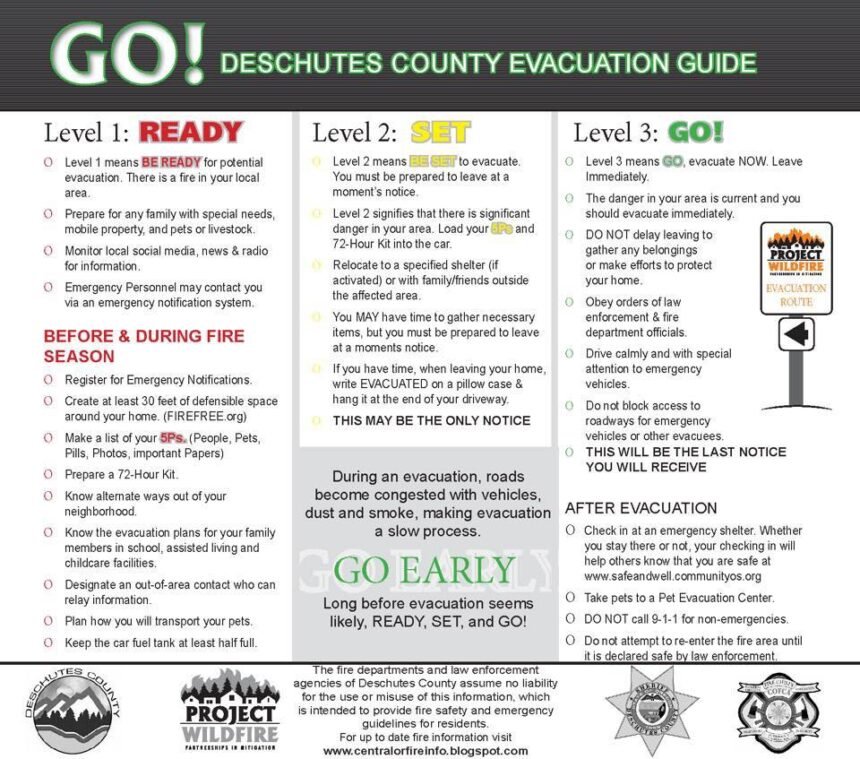
Level 2: Means “BE SET” to evacuate. You must prepare to leave at a moment’s notice. This level indicates there is significant danger to your area, and residents should either voluntary relocate to a shelter or with family and friends outside of the affected area, or if choosing to remain, to be ready to evacuate at a moment’s notice. Residents MAY have time to gather necessary items, but doing so is at their own risk. This may be the only notice you receive. Emergency services cannot guarantee that they will be able to notify you if conditions rapidly deteriorate. Area media services will be asked to broadcast periodic updates.
A Level 1 (Get Set) Pre-Evacuation notice is issued for the following areas: Residences along the south side of Indian Ford Road from Hwy 20 to Stevens Canyon Road; residences east of Fly Lake Rd (FS 2055) to Stevens Canyon Rd (including all residences along Stevens Canyon Rd); and private residences and campgrounds west of USFS 14 within the Metolius Basin in the Camp Sherman area.
Level 1: Means “BE READY“ for potential evacuation. Residents should be aware of the danger that exists in their area, monitor emergency services websites and local media outlets for information. This is the time for preparation and precautionary movements of persons with special needs, mobile property and (under certain circumstances) pets and livestock. If conditions worsen, emergency services personnel may contact you via an emergency notification system.
This decision was made after consultation with fire managers and authorized by Sheriffs L. Shane Nelson and Jim Adkins. We will continue to work with fire managers to ensure public safety and prevent conflicts between citizens and fire operations. We appreciate the cooperation and understanding of residents.
Please avoid these evacuation areas and abide by any area closures issued by the Deschutes National Forest.
Follow the Deschutes County Sheriff’s Office on Twitter and Facebook for up to date information.
Current maps including evacuation areas can be found at:
For fire information, you can visit the Central Oregon Fire Information site at:
---
Here's the earlier announcement issued by Frontier Dispatch at Jefferson County Sheriff Jim Adkins' direction:
Level 1 Evacuation Notice "BE READY"
There is a wildfire on Green Ridge and people residing in the Camp Sherman area should be aware of a potential evacuation order. Be aware of the danger, monitor emergency service sources and local media for information.
Those persons who will need additional time to exit an area or have health conditions (especially respiratory conditions that could be made worse by smoke) should consider leaving now. You are encouraged to prepare or even move livestock and pets out of the area. Be prepared to leave if conditions worsen.
Level 1 Evacuation notice is being sent to all persons residing in the Camp Sherman area. This order does NOT affect the rest of Jefferson County.
This order is authorized by Sheriff Jim Adkins of the Jefferson County Sheriff's Office
Approved Oregon Evacuation Levels
LEVEL 1: A Level 1 Evacuation means “BE READY” for potential evacuation. Residents should be aware of the danger that exists in their area, monitor emergency services websites and local media outlets for information. This is the time for preparation and precautionary movement of persons with special needs, mobile property and (under certain circumstances) pets and livestock. If conditions worsen, emergency services personnel may contact you via an emergency notification system.
LEVEL 2: A Level 2 Evacuation means “BE SET” to evacuate. YOU MUST PREPARE TO LEAVE AT A MOMENTS NOTICE This level indicates there is significant danger to your area, and residents should either voluntarily relocate to a shelter or with family/friends outside of the affected area, or if choosing to remain, to be ready to evacuate at a moment’s notice. Residents MAY have time to gather necessary items, but doing so is at their own risk. THIS MAY BE THE ONLY NOTICE THAT YOU RECEIVE Emergency services cannot guarantee that they will be able to notify you if conditions rapidly deteriorate. Area media services will be asked to broadcast periodic updates.
LEVEL 3: A Level 3 Evacuation means “GO” Evacuate NOW LEAVE IMMEDIATELY! Danger to your area is current or imminent, and you should evacuate immediately. If you choose to ignore this advisement, you must understand that emergency services may not be available to assist you further. DO NOT delay leaving to gather any belongings or make efforts to protect your home. THIS WILL BE THE LAST NOTICE THAT YOU RECEIVE Entry to evacuated areas may be denied until conditions are safe. Area radio and TV stations have been asked to broadcast periodic updates.
Here's the Wednesday morning update from the Central Oregon Interagency Dispatch Center:
Central Oregon Interagency Dispatch Update, August 19 9:30 a.m.
Central Oregon – Firefighters are responding to two new incidents in Central Oregon today, including a 200-acre fire burning near the South Fork of the John Day River. Gusty winds are expected along the Cascade crest today, which will challenge firefighting suppression efforts.
The Green Ridge Fire remains an estimated 500 acres burning on the Deschutes National Forest and private land protected by the Oregon Department of Forestry with 5% containment this morning. A Type 2 Incident Management Team has taken command of the fire as of 6:00 a.m. this morning. An area closure will soon be put in place for the safety of the public and firefighters working in the area. There are no evacuations at this time.
There was minimal growth on the Lily Fire in the Charlton Roadless Area on the Deschutes National Forest last night. It remains an estimated 30 acres with 10% containment. With forecast winds, firefighters will be challenged with increased fire behavior today which is burning in the 1996 Charlton Fire scar and into nearby heavy timber. Officials will be putting into place an area closure for the safety of the public and firefighters working in the area that will include some portions of the Pacific Crest Trail.
The Frog Fire in the Maury Mountains on the Ochoco National Forest east of Prineville is now estimated to be 50 acres with no containment. A Type 3 Incident Management Team has taken command of the fire and will be continuing to construct preliminary fire lines by hand and then scouting for opportunities for a potential burnout operation in the next few days when conditions are favorable.
Additionally, there are two new incidents in Central Oregon — Incident #728 near the South Fork of the John Day River, called the Peewee Creek Fire, that is estimated at 12 acres, Incident #739, estimated at 200 acres, near Jerry Mountain approximately 15 miles west of Dayville, north of Highway 26.
For up-to-date information on Central Oregon fires, visit www.centraloregonfire.org or www.twitter.com/CentralORFire
News release from the Deschutes National Forest:
Deschutes and Willamette National Forests Implement Area Closure for Lily Lake Fire
Lily Lake Fire Burning in Charlton Roadless Area Prompts Closures That Include Portion of PCT
Bend, Ore.- Effective immediately,Deschutes and Willamette National Forest officials have placed an area closure for the Lily Lake Fire burning northeast of Lily Lake within the Charlton Roadless Area west of the Cascade Lakes Highway. The Lily Lake Fire, which started August 17 and is now estimated at 30 acres, is burning within the 1996 Charlton Fire Scar and adjacent heavy timber. The heel of the fire is located within 100 feet of the Pacific Crest Trail (PCT). The fire is 10% contained and continues to grow to the north and east prompting area and trail closures.
The following area closure is in place (see attached map):
Northern Closure Boundary
From the boundary between the Willamette National Forest and the Deschutes National Forest (T 20S, R 6E, Section 26) at the junction of the 517 road and 4636 road, heading east and including all lands south of the 4636 road, but not including the 4636 road, to the intersection of the Many Lakes trailhead, but not including the Many Lakes Trailhead.
Eastern Closure Boundary
From the intersection of the Many Lakes Trailhead, south along trail 99, all lands west of trail 99, but not including trail 99, to road 4290.
Southern Closure Boundary
From the intersection of trail 99 and road 4290, west along road 4290 to the intersection of the 4290 and trail 3593, all lands north of road 4290, but not including road 4290.
Western Closure Boundary
From the intersection of the 4290 and trail 3593, west to the intersection of trail 3593 and road 5898, all land north of trail 3593, but not including trail 3593. North along road 5898 to Harralson Horse Camp, all lands east of road 5898, but not including the 5898 road or Harralson Horse Camp. West along trail 4634 until the intersection of trail 4634 and road 514, all lands north of trail 4634, but not including trail 4634. North along the 514 road to the intersection of the 517 road, all lands east of the 514 road, but not including the 514 road. East along the 517 road, all lands south of the 517 road, but not including the 517 road, until the boundary between the Willamette National Forest and the Deschutes National Forest at the junction of the 517 road and 4636 road
The following trail closures are in place:
Deschutes & Willamette National Forest Trails
- Pacific Crest Trail, from road 4290 to road 4636
Deschutes National Forest Trails
- Charlton Trail 19, from road 4290 to junction with trail 99
- Clover Meadow Trail 21
Willamette National Forest Trails
- Harralson Trail 4364, from Harralson Horse Camp to the Pacific Crest Trail
There are no road closures at this time.
Earlier story:
BEND, Ore. (KTVZ) -- Gusty winds and heat increased fire behavior Tuesday on several lightning-sparked blazes across Central Oregon, two of which grew quickly to cover hundreds of acres near Camp Sherman and on the Warm Springs Indian Reservation.
The Green Ridge Fire, two miles northeast of Camp Sherman on the Deschutes National Forest, was still estimated Wednesday morning Tuesday at 500 acres.
Officials said in a Tuesday night update that the fire "saw tremendous growth today as wind pushed it east onto private land protected by the Oregon Department of Forestry."
Aerial resources assisted by cooling hot spots and laying down retardant to slow the progression of the fire, which remained 5% contained late Tuesday.
Crews worked late into the night, taking advantage of more moderate fire conditions to build lines with bulldozers and interagency hotshot crews.
Crews were working to construct and improve fire lines across the fire, including bulldozer crews who were working through the night to put in direct fire line on the east flank of the fire to prevent further fire spread onto private land. They also will be patrolling for spot fires in the area.
A Type 2 Incident Management Team takes command of the fire at 6 a.m. Wednesday, which will bring in additional resources to help contain the fire.
While there are no evacuations currently in place, forest officials will be putting in place an area closure Wednesday that includes Forest Road 11 north of the Black Butte Trailhead.
Smokejumpers and a hand crew from the Willamette National Forest continued to work on the Lily Fire northeast of Lily Lake in the Charlton Roadless Area on the Deschutes National Forest.
The fire continued to burn through the 1996 Charlton Fire scar and into nearby heavy timber, growing to the north and east, and was estimated Tuesday night to be 30 acres and 10% contained.
The heel of the fire is within 100 feet of the Pacific Crest Trail and Willamette and Deschutes national forest officials have worked together with the Pacific Crest Trail Association to monitor and address the situation by looking at closures and trail reroutes. Officials expect the closures will be put into place Wednesday.
Meanwhile, the Frog Fire in the Maury Mountains on the Ochoco National Forest east of Prineville is now estimated to be 40 acres with no containment.
A spot fire that started Monday night grew together with the main fire during the day, though fire behavior was somewhat moderated by the assistance of a heavy helicopter cooling hot spots while crews continued to construct fire line.
Steep terrain remains a challenge on the north side of the fire, burning in thick timber. Crews were working late into the night to begin prepping for a possible burnout operation in the next few days, if conditions are favorable.
A Type 3 Incident Management Team is expected to take command of the fire Wednesday.
But the Green Ridge Fire was not the region’s largest as of late Tuesday. On the southwest portion of the Warm Springs Indian Reservation, the P-515 Fire grew to about 772 acres, burning in terrain that includes steep slopes, brush and dense timber, officials said.
Elsewhere on the reservation, the Lion’s Head Fire grew to about 144 acres, in thick, brushy fuels and on several steep slopes. A third active fire, the Quartz Butte Fire, was at about 27 acres. Bulldozer crews were able to complete a line around the fire perimeter.
Eighty to 100 firefighters were working on the blazes.
For up-to-date information on Central Oregon fires, visit www.centraloregonfire.org or www.twitter.com/CentralORFire
