Wind-driven Bootleg Fire near Sprague River grows to nearly 39,000 acres; evacuations in place
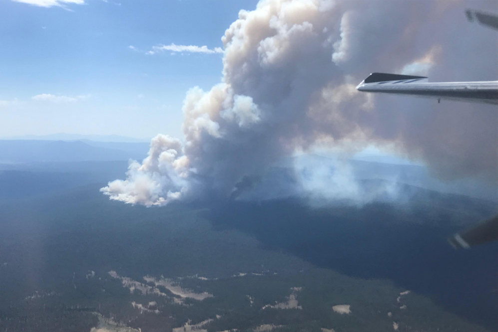
SPRAGUE RIVER, Ore. (KTVZ) -- The wind- and heat-fanned Bootleg Fire continues to grow rapidly, to nearly 39,000 acres as of Friday morning, burning on the Fremont-Winema National Forest and private lands north of the towns of Sprague River and Beatty.
Although a Red Flag Warning is no longer in effect, weather conditions overnight and through Friday continue to allow for extreme fire behavior, officials said. Additional resources have been ordered and continue to arrive.
BOOTLEG FIRE UPDATE 7/9/21 (11 a.m.)
NORTHWEST INCIDENT MANAGEMENT TEAM 10
Incident Commander: Al Lawson
Yesterday’s operations:
Firefighters continued their efforts to identify defensible locations for effective
fire breaks and to safely engage the fire. Crews were successful at limiting the
spread along the southern edge. However, during the day and into the evening,
wind-driven extreme fire behavior resulted in active fire growth to the east.
Officials are in the process of assessing the impacts of yesterday’s fire spread.
Today’s operations:
In addition to ongoing daytime operations, more crews are being assigned to
night shift when conditions are more favorable for effective firefighting. As part
of the unified command and in addition to the wildland firefighting efforts
underway, the Office of the Oregon State Fire Marshal’s Green Incident
Management Team remains on scene with 3 task forces focused on structural
triage and, when possible, creating defensible space around structures on both
day and night shift. Today, 2 more structural strike teams from California and
an Oregon task force have arrived, with additional resources on order.
Evacuations:
At the recommendation of the Bootleg Fire Incident Commander, following are the
current evacuation levels issued by Klamath County Emergency Management:
Level 3 (Go) – Leave immediately
• (NEW) North of the town of Beatty. North end of Godawa Springs Road
north of the rock quarry.
• Near the town of Sprague River. Upper Tableland area north of Oregon
Pines Road.
• North of the town of Beatty. Sycan Estates area.
Level 2 (Get Set) - Be ready to leave at a moment’s notice
• North of the town of Beatty. The area north of Highway 140, on both
sides of Godowa Springs Road, south of the rock quarry.
• North of the town of Sprague River. Klamath Forest Estates/Moccasin
Hills area.
Evacuation Center
Klamath County Fairgrounds (in Klamath Falls), South 6th Street entrance only.
Public meetings:
• 11 a.m. - Sprague River Community Center
• 7 p.m. - Chiloquin Community Center
• Attend the meetings in person or watch the 7 p.m. meeting on
Facebook Live on SCOFMP Fire Info, Northwest Team 10 and FremontWinema National Forest Facebook pages.
Closures:
The Fremont-Winema National Forest is closed in the area of the fire. See maps
and the Emergency Fire Closure Order 06-02-21-03 at
www.fs.usda.gov/alerts/Fremont-winema/alerts-notices or on InciWeb.
Safety Message:
Watch for increased fire equipment traffic on area roads and highways,
particularly in the Chiloquin area – use caution and drive defensively!
SIZE: 38,892 acres
CONTAINMENT: 0%
PERSONNEL: 328
CAUSE: Under Investigation
RESOURCES:
Hand Crews 19
Engines 22
Dozers 2
Water Tenders 3
AIRCRAFT:
Helicopters 10
Data as of 7/9/21: 8 a.m.
FIRE INFORMATION:
Phone: 541-363-7765
Email: 2021.bootleg@firenet.gov
Web: inciweb.nwcg.gov/incident/7609/
Facebook: SCOFMP Fire Info
Facebook: Northwest Incident
Management Team 10
Facebook: Fremont-Winema NF
FIRE PREVENTION:
Conditions are unseasonably hot and
dry this year. Please use caution
with anything that can spark a fire!
Report suspected wildfires
immediately to 911.
SMOKE:
Smoke is expected to continue to
impact the local area. Find more
info at
www.oregonsmoke.blogspot.com
Elsewhere, the Jack Fire, along Highway 138E about 40 miles east of Roseburg, has grown to nearly 5,500 acres and also remains 0% contained, officials said Friday. More information at: https://inciweb.nwcg.gov/incident/7605/
Meanwhile, the lightning-sparked Lewis Rock Fire five miles south of Mitchell, reported June 30, is mapped at 368 acres and 45% contained, with more than 400 firefighters engaged in full mop-up efforts. More information at: https://inciweb.nwcg.gov/incident/7604/
