McCaffery Fire near Redmond Airport burns over 450 acres, 10% contained; record heat, wind to test lines, firefighting effort
(Update: New acreage figure, first containment; full Sunday AM update)
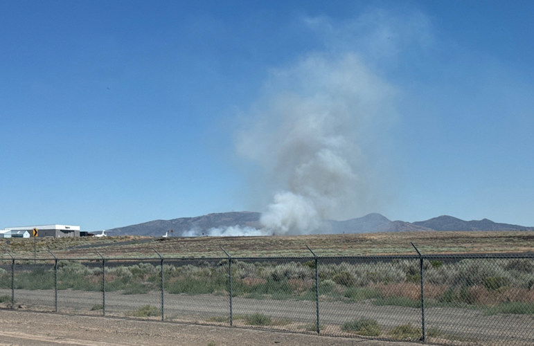
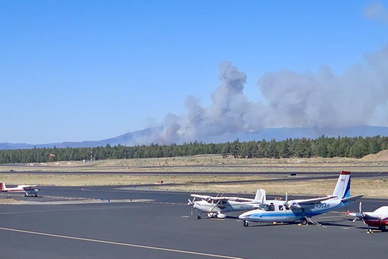
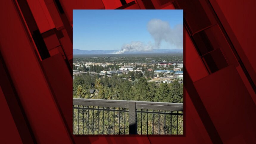
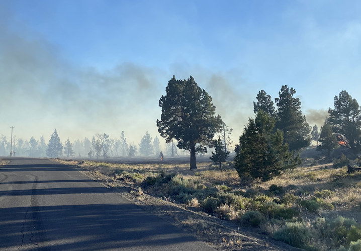
REDMOND, Ore. (KTVZ) – A wind-fanned wildfire broke out amid very hot, dry conditions south of Highway 126 and southeast of Redmond Airport Saturday afternoon, stopping flights for hours as it burned over 450 acres and prompted evacuations. An air and ground attack slowed its spread, but Sunday's return of heat and wind will be a major test.
A Sunday morning update on the Central Oregon Fire X/Twitter feed said the blaze had burned 458 acres but was now 10% contained.
Kelsey McGee will be speaking Sunday with Forest Service Public Affairs Officer Kassidy Kern and others to find out the latest status of the firefighting effort, and the main tasks at hand. Her report will be on NewsChannel 21 at Six.
Central Oregon Interagency Dispatch Update – July 7, 2024 | McCaffery Fire
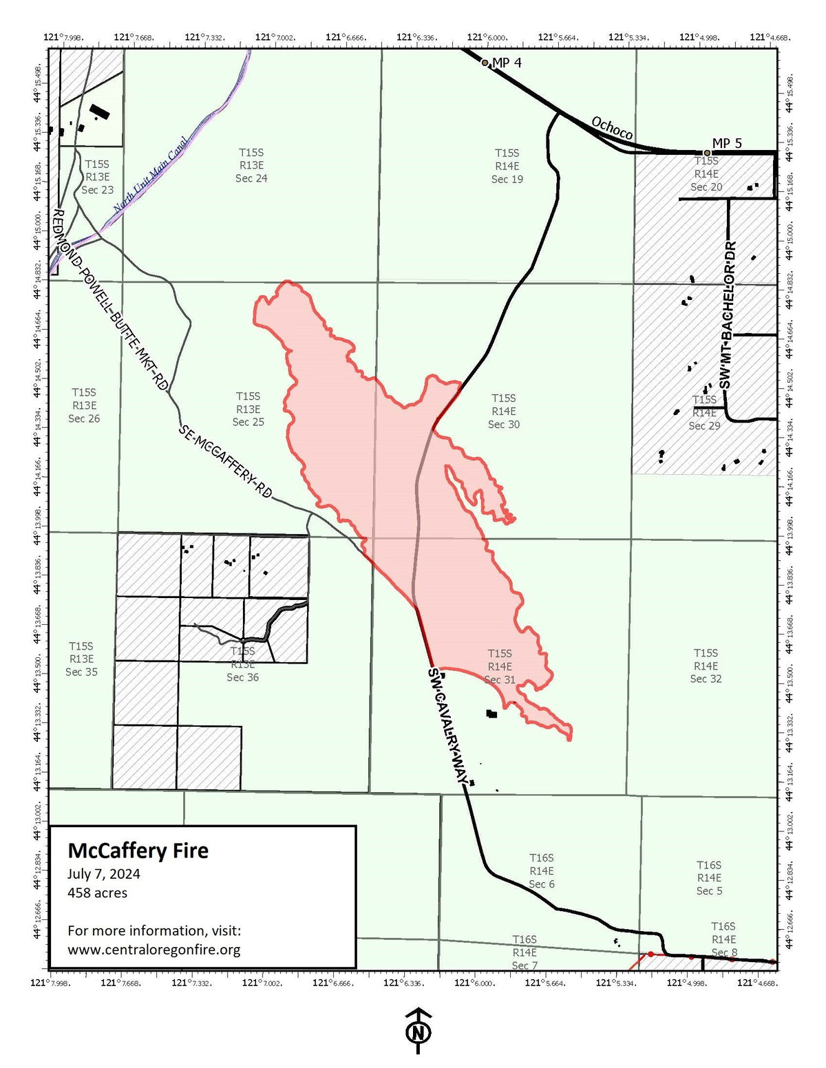
Central Oregon — A Central Oregon Type 3 incident management team took command of the McCaffery Fire today at 6:00 am. The fire is burning east of the Redmond Airport and south of Highway 126 on Prineville District Bureau of Land Management (BLM) lands near the Oregon Army National Guard Biak Training Center. The McCaffery Fire is now 458 acres and 10% contained.
Firefighters worked through the night to put preliminary containment lines around the fire perimeter. The McCaffery Fire is not a solid black burned area; this burn is very spotty and fire managers anticipate additional work will be needed to refine the containment lines as temperatures heat up today and possible spots are found outside of the preliminary lines.
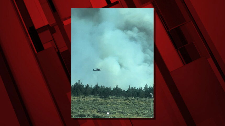
Two heavy helicopters are assigned to the fire to assist firefighters on the ground in cooling hot spots and securing the perimeter. Multiple air tankers remain available to the team, along with 12 engines, 2 dozers, 2 skidgines, 2 water tenders, and 1 Type 2 initial attack crew.
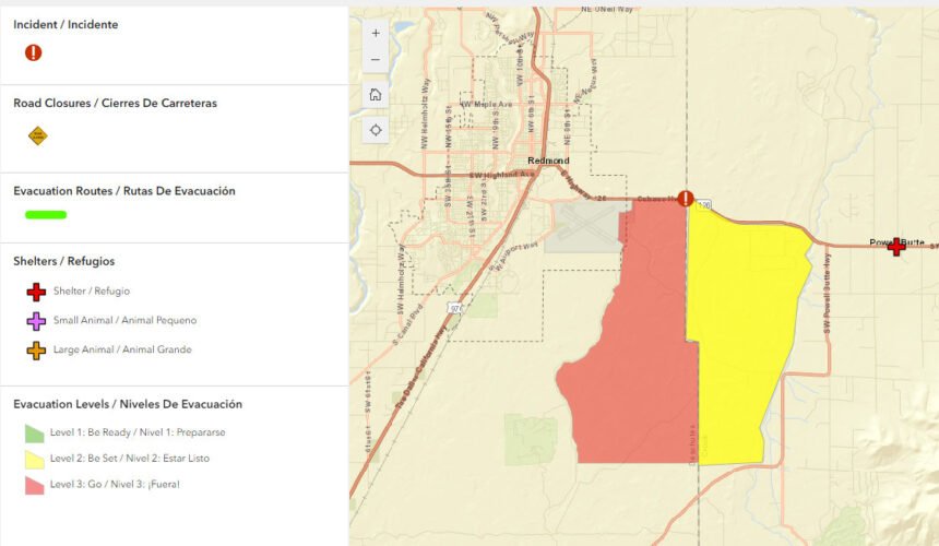
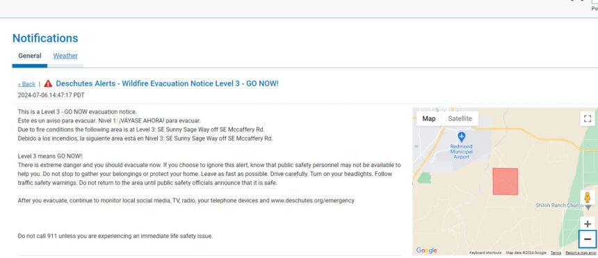
A Level 3 “Go Now” remains in effect for the areas on Sunny Sage Road off of McCaffery Road in Deschutes County. Crook County Sheriff’s Office has a Level 2 “Be Set” evacuation notice in place for the area of west Powell Butte Estates and the area to the south of Powell Butte Highway in Crook County. Stay up to date on Crook County Emergency Alerts by visiting: http://www.alertcrookcounty.org/
For Deschutes County Emergency Alerts, text “COFIRE” to 888-777.
Record high temperatures are forecast for today with wind gusts up to 20 mph in the afternoon. The public is asked to stay out of the McCaffery Fire area for their safety, as well as the safety of firefighters and equipment working to contain the fire.
The cause of the fire is under investigation.
--
Earlier information:
Incident 353, named the McCaffery Fire for McCaffery Road in the area the fire began, was reported shortly after 2 p.m. on Prineville BLM-managed land near the Deschutes/Crook county line, east of Redmond and west of Powell Butte.
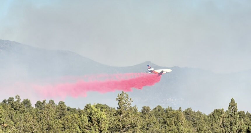
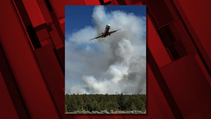
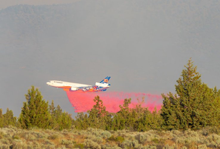
Several Forest Service and BLM crews quickly responded to assist Redmond firefighters during the afternoon, along with two single-engine air tankers (SEAT planes) to drop retardant, joined structural-protection task forces.
Three Large Air Tankers (LATs) helped firefighters on the ground, which also included private crews and a bulldozer, officials said early Saturday evening. They added that the fire at last report was still three miles from any structures.
Around 7:25 p.m., officials said in an update that "retardant drops have slowed the spread of the fire. Dozers and engine crews are working on flanking the fire at this time."
Redmond Airport's airfield closed for several hours on Saturday "due to adjacent wildfire fighting efforts" but reopened Saturday night.
They said the airfield had been closed "to dedicate air space to aerial firefighting efforts just east of the airfield." However, they said the terminal remained open and urged travelers to check with your air carrier directly for flight status updates and any cancellations.
Meanwhile, west of Bend, firefighters Saturday night stopped another new fire, Incident 356, off Forest Road 4615, two miles south of Skyliners Sno-Park. It was contained at a quarter-acre.
The Deschutes County Sheriff’s Office issued an initial Level 3 GO NOW evacuation notice shortly before 3 p.m. for SE Sunny Sage Way off McCaffery Road. Soon, an area of Crook County faced the same evacuations, but their Level 3 was reduced to Level 2 by 10 p.m.
UPDATE July 6, 2024 10:00 PM
Level 3: Go Now will remain in effect for the areas on Sunny Sage Rd. off of McCaffery Rd. in Deschutes County.
Level 3 has been reduced to Level 2: Be Set for the area of west Powell Butte Estates and the area to the south to Powell Butte Hwy. in Crook County.
Level 2 means Be Set:
Be ready to evacuate at a moment’s notice. Find resources at www.deschutes.org/emergency. Monitor local social media, TV, radio, and telephone devices. Act early if there is any reason you might need extra time. Leave right away if you feel you are in immediate danger.
If conditions change quickly, this may be the only alert you receive.
--
Level 3: means “GO” evacuate now. Leave immediately! Danger to your area is current or imminent, and you should evacuate immediately. If you choose to ignore this advisement, you must understand that emergency services may not be available to assist you further. DO NOT delay leaving to gather any belongings or make efforts to protect your home. This will be the last notice you receive.
A Temporary Evacuation Point was established at the Powell Butte Church.
Large animals can be sheltered at the Crook County Fairgrounds.
Current maps including evacuation areas can be found at: https://deschutes.org/emergency
For fire information, you can visit the Central Oregon Fire information site at: www.centraloregonfire.org
Make sure you are registered for Deschutes Alerts to receive evacuation and emergency alert and warnings in your area by going to: www.deschutesalerts.org.
Crook County Sheriff John Gautney said Redmond Airport was giving priority traffic to fire aircraft. He said the fire was under the command of BLM, with a joint command with Prineville and Redmond Fire, the Oregon State Fire Marshal's Office and the Crook and Deschutes County sheriff's offices.
Pacific Power's outage map showed two "emergency de-energizations" in the area of the fire, affecting 176 customers. Crews were investigating a larger outage affecting 1,733 customers on Bend's south end.