Cow Valley Fire grows to 132,000 acres, but more progress seen; threat to community has ‘significantly decreased’
(Update: Sunday evening update; changes to evacuation levels_
IRONSIDE, Ore. (KTVZ) – The 4-day-old Cow Valley Fire in Eastern Oregon's Malheur County grew to more than 132,000 acres by Monday, but officials said the threat to nearby communities has "significantly decreased" after sheriff's deputies raised some evacuation levels in areas of significant growth and reduced them in areas where the danger had lessened.
Monday morning's update:
Daily Update: Monday, July 15, 2024
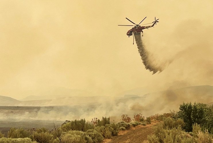
Firefighters are working around the clock to suppress the Cow Valley Fire. There is currently a day shift, swing shift, and night shift operating as fire conditions allow. The fire is 132,528 acres. Most of the fire growth was wind driven and occurred on the western edge towards East Prong Dry Creek. Yesterday, firefighters continued to create line around the fire on the northern, eastern, and southern edges. Aviation resources dropped water and fire retardant on the western edges of the fire, slowing the rate of fire growth. The current perimeter around the fire is 163 miles long. Fire edges remain south of the Malheur Reservoir, east of Brogan and Jamieson, and north of Bully Creek Reservoir.
Oregon State Fire Marshal task forces continued to work on structure protection efforts in the communities along Highway 26 and in Westfall—in addition to assisting firefighting efforts on the southern edge of the fire.
The threat to the local community has significantly decreased and the number of wildland firefighters on the incident have increased. For that reason, the Oregon State Fire Marshal has begun to right-size resources on the Cow Valley Fire. One task force was demobilized yesterday. Today, two task forces will continue to support structure protection on the Cow Valley Fire and two will be sent to emerging fires across the state.
The fire burned throughout the night. Winds died down around 3:00 a.m. This, in addition to higher humidity levels and lower temperatures, allowed night crews to continue their progress. Today, firefighters will explore options on the southwestern edge to connect the leading edges together. Resources in other areas will strengthen and secure firelines around the perimeter using tactics known as cold trailing and mop up – where they use tools and water to extinguish heat. Firefighters will also work with aviation as weather allows.
An Unmanned Aerial System, also known as a UAS or drone, with infrared technology will be used during day and night shifts to monitor for hot spots that threaten the integrity of the fireline. The UAS could also be used for strategic firing operations if needed.
BONITA FIRE: No major growth was reported on the Bonita fire. Crews will continue to secure the fireline and search for hot spots.
WEATHER AND SMOKE: Today’s temperatures will be slightly cooler with a forecasted high of 96 degrees Fahrenheit and slightly higher humidity levels. Extreme fire behavior is still possible based on fuel and weather conditions. Winds will be moving east at 5-8 mph, with gusts up to 15 mph.
Smoke from neighboring fires will drift towards the area with the wind. For the current smoke information and the air quality index, visit airnow.gov.
EVACUATIONS AND CLOSURES: The Malheur County Sheriff's Office issued updated evacuation orders on July 14. Check below for details or visit the Malheur County Sheriff’s Office Facebook page.
Level 1 – Be Ready – Green
Residents along Hwy 26 Corridor (Willowcreek, Jamieson, Brogan) and NW of Vale (Graham Blvd and North, Alder Road and west).
Level 1, or “Get Ready,” evacuation means residents should prepare to evacuate and start packing essentials for themselves, pets, and livestock.
Level 2 – Be Set – Yellow
Residents in the Westfall area (including Bonita, Indian Valley, Clover Creek areas).
Level 2, or “Get Set,” evacuation means that there is high danger in the area and residents should prepare to leave at a moment's notice. If you or your family require additional time to evacuate, now is the time to do so.
Level 3 – GO NOW – Red
None at this time.
Level 3, or “Go Now,” evacuation means that there is immediate danger. Leave without delay and do not return until officials announce that the area is safe.
BURN BAN: A burn ban is currently in effect for all of Malheur County. For more information, visit https://www.malheurco.org/category/public-notices/.
TEMPORARY FLIGHT RESTRICTION: A temporary flight restriction is in place for the safety of the public and firefighting aviation resources. If you fly, we can’t; if a drone or other aircraft enters the air space, all firefighting aviation equipment will be grounded.
Start date: July 11, 2024
Location: 9 miles east of Ironside, OR
Total personnel: 362
Fire size: 132,528
Cause: Human caused, under investigation
Containment: 0%
Fire Information Phone Number: 541-208-4371, staffed 7a.m. to 7 p.m. MDT
Fire Information Email Address: 2024.cowvalley@firenet.gov
--
For the most up-to-date evacuation information, please visit the Malheur County Sheriff’s Office page on Facebook.
https://www.facebook.com/profile.php?id=100069245917855
For additional information and updates on the Cow Valley Fire, visit https://www.facebook.com/profile.php?id=61562017027302
--
Governor Kotek invokes Emergency Conflagration Act in response to Cow Valley Fire
Cow Valley Fire burning in Malheur County, northwest of Vale
Salem, OR — Governor Tina Kotek invoked the Emergency Conflagration Act on the morning of July 12, 2024, in response to a wildfire in Malheur County: the Cow Valley Fire. The resources necessary for protecting life and property from the Cow Valley Fire are beyond local capabilities. Assistance with life, safety, and structural fire protection was requested by the Malheur County Fire Defense Board and the state fire marshal concurred with that request.
“Wildfire season is in full swing, with fires active across Oregon and concerning weather conditions for this upcoming weekend,” Governor Kotek said. “I am authorizing an emergency conflagration to allow additional resources to fight the Cow Valley Fire in Malheur County. The majority of our state’s wildfires are human-caused. I urge all Oregonians to take extreme precautions, particularly with lightning in the forecast for this weekend. It is incumbent on all of us to keep Oregon green and protect our communities.”
A link to Executive Order 24-12 can be found here.
Following ORS 476.510-476.610, Governor Kotek determined that a threat to life, safety, and property exists due to the fire, and the threat exceeds the firefighting capabilities of local firefighting personnel and equipment. The governor’s declaration cleared the way for the state fire marshal to mobilize resources through the Oregon Fire Mutual Aid System to support local fire service agencies on scene. This conflagration is declared only for the Cow Valley Fire threatening structures in Malheur County.
The Oregon State Fire Marshal’s Red Incident Management Team was mobilized. Along with the federal partners, our rangeland fire protective associations and local responding agencies, two structural task forces were mobilized Thursday night through the agency’s Immediate Response tool. Two more task forces from Lane and Marion counties were mobilized. The Red Incident Management Team will be in unified command with Northwest Team 6, a federal complex incident management team.
For the latest on evacuations, please follow the Malheur County Sheriff’s Office.
--
Here's the Friday morning release on the fire by the Oregon State Fire Marshal's Office:
Cow Valley Fire in Malheur County declared a conflagration, OSFM sending additional resources
Oregon State Fire Marshal - 07/12/24 10:12 AM
SALEM, Ore. (KTVZ) – The Oregon State Fire Marshal is mobilizing several task forces and its Red Incident Management Team to the Cow Valley Fire in Malheur County to protect people and property. Overnight Thursday, the agency sent two task forces from Umatilla and Multnomah counties through Immediate Response. These task forces will be joined by two others from Lane and Marion counties.
“The weather conditions we are seeing across Oregon are extremely concerning. The forecast over the weekend for much of Eastern Oregon will not be doing us any favors,” Oregon State Fire Marshal Mariana Ruiz-Temple said. “The state has seen numerous human-caused wildfires over the last few weeks, and I am asking everyone to be careful and aware of the extreme fire conditions, especially with lightning in the forecast.”
According to the Vale Bureau of Land Management District, the fire is being pushed by gusty winds, triple-digit temperatures, and low humidity, causing substantial fire growth in the last 12 hours. An infrared flight is happening this morning to get an accurate size of the fire. That information will be shared once it is available. Weather for this fire is expected to be challenging over the next few days with a Fire Weather Watch in place by the National Weather Service for abundant lightning and wind this weekend.
The OSFM’s Red Incident Management Team will be in unified command with Northwest Team 6, a federal complex incident management team.
Malheur County Emergency Management and the Red Cross have a shelter in Girvin Hall at the Malheur County Fairgrounds. Those who have questions about the shelter should call 208-519-6675.
Evacuation notices will be issued by the Malheur County Sheriff’s Office. A Facebook page is set up to share Cow Valley Fire information.
On Friday morning, Oregon Governor Tina Kotek invoked the Emergency Conflagration Act for the fire which allows the state fire marshal to mobilize state resources to protect life and property.
Following ORS 476.510-476.610, Governor Kotek determined that threats to life, safety, and property exist because of the fire, and the threats exceed the capabilities of local firefighting personnel and equipment.
ODOT shared photos on TripCheck of the Cow Valley Fire on its TripCheck page and said the highway was expected to remain closed through the night. Crews will assess the situation and provide an update in the morning.
KTVB in Boise reported 30-50 homes in Brogan are threatened, and power needed to be shut off to some due to the fire’s proximity to power lines.
The Malheur County Sheriff’s Office said on Facebook the Cow Valley Fire had changed direction and was growing quickly to the east, toward the town of Brogan, population of about 90. It was burning on both sides of the highway.
It was one of three large new blazes in the area, according to Watch Duty, the others being the day-old, 4,504-acre Huntington Mutual Aid Fire in Baker County, prompting evacuations and alerts in the Huntington area and Farewell Bend State Park, and the 1,867-acre Bonita Road Fire, also in Malheur County, reported early Thursday morning.
--
Oregon State Fire Marshal sends two task forces to Cow Valley Fire (Photo)
Oregon State Fire Marshal - 07/11/24 9:20 PM
SALEM, Ore. – A fast-moving wildfire Thursday evening in Malheur County prompted the Oregon State Fire Marshal to mobilize two structural task forces to the Cow Valley Fire burning near the town of Brogan. The task forces from Umatilla and Multnomah counties are being sent through Immediate Response, a tool the state fire marshal uses to mobilize task forces outside of a conflagration.
“The east side of the state has faced challenging fire conditions over the last week. The Cow Valley Fire is being pushed by gusty winds and low humidity,” Oregon State Fire Marshal Mariana Ruiz-Temple said. “We are using an essential tool and the power of the Oregon Fire Mutual Aid System to provide added resources to the Cow Valley Fire. Firefighters funded through the 2024 Wildfire Season Staffing Grant allowed a quicker response for the local agencies.”
The fire is rapidly changing and estimated to be about 16,000 acres, according to the Vale Bureau of Land Management District and threatening 30 to 50 homes.
According to the Malheur County Sheriff’s Office, the Cow Valley Fire changed direction early Thursday evening and headed east toward the town quickly. The sheriff’s office is advising those in Brogan and the surrounding areas to be prepared to leave their home if an evacuation order is made. Follow the Malheur County Sheriff’s Office for information about evacuations.
The Oregon Department of Transportation closed a stretch of Highway 26 in the area of the fire. The agency says the highway is expected to remain closed through the night.
The Umatilla County task force is made up of local fire agencies from Umatilla, Baker, Gilliam, Morrow, and Union counties.
The task force from Multnomah County was previously assigned to the Larch Creek Fire. The Oregon State Fire Marshal will continue to monitor the fire and is ready to provide more support if needed.
About Immediate Response
Immediate Response is made possible through the OSFM’s Response Ready Oregon program created through Oregon’s wildfire omnibus bill, Senate Bill 762, signed into law in 2021.

