Governor invokes 15th, 16th Conflagration Acts for 107,000-acre Rail Ridge Fire, 24,000-acre Shoe Fly Fire
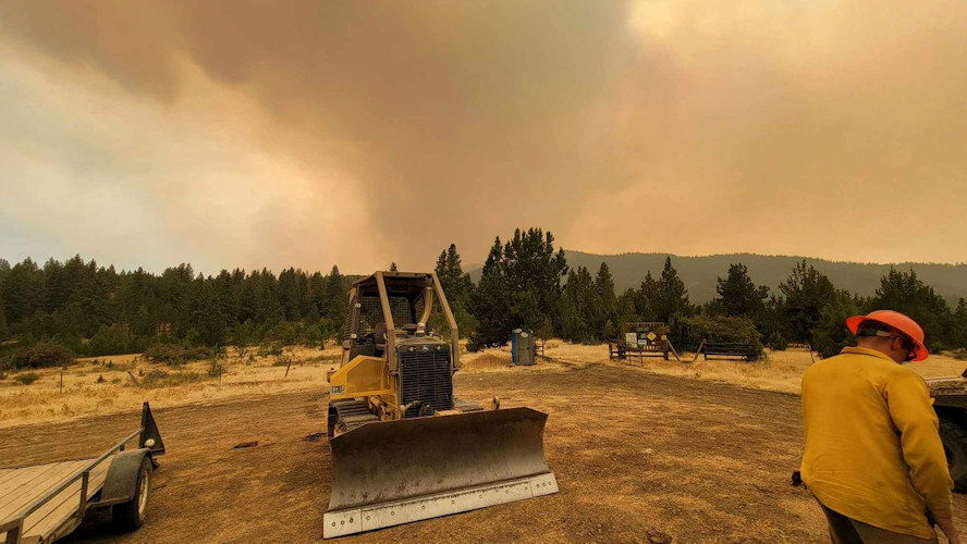
Nearly 6,400 personnel on 23 large fires across state; we have updates on several in our region
SALEM, Ore. (KTVZ) - The Oregon State Fire Marshal is mobilizing its Blue Incident Management Team and several task forces to the Rail Ridge Fire in Grant and Crook counties and the Shoe Fly Fire in Wheeler County. Governor Tina Kotek invoked the Conflagration Act for both fires Friday.
The Rail Ridge Fire is estimated at 107,371 acres and 3 percent contained as of Friday morning. The lightning-sparked fire was detected on Wednesday and grew rapidly, pushed by extremely hot, dry and windy conditions over the last few days.
The OSFM Blue Team will be in unified command with California Team 10, a complex incident management team, which took command of the Rail Ridge Fire Friday morning. Earlier this week, the OSFM mobilized two task forces from Central Oregon and Marion County through Immediate Response. These task forces will be joined by three others later this evening.
“The conditions we are seeing on the ground are very dynamic, with several fires burning in the region and a cold front is expected to pass through. There’s no real relief in the forecast over the weekend and into early next week,” Oregon State Fire Marshal Mariana Ruiz-Temple said. “The Oregon fire service has been extremely busy over the last few months, and I cannot thank them enough for being ready to respond to help their fellow Oregonians when they need it.”
The Shoe Fly Fire is estimated to be 24,188 acres and 6 percent contained. It was reported on Monday, Sept. 2. The OSFM mobilized two task forces from Clackamas and Multnomah counties through Immediate Response earlier this week. The OSFM Blue Team will work with the Oregon Department of Forestry Incident Management Team 1, which is assigned to the Shoe Fly Fire to provide structural protection support.
These conflagrations mark the 15th and 16th invoked this summer. With extreme heat expected across the state into the weekend, the Oregon State Fire Marshal reminds all Oregonians and visitors to pay close attention to the conditions and take the necessary steps to avoid sparking a wildfire.
About the Emergency Conflagration Act
The Emergency Conflagration Act is invoked by Oregon Governor Tina Kotek, allowing the state fire marshal to mobilize state resources to wildfires to protect life and property.
The conflagration act is invoked following ORS 476.510-476.610 when Governor Kotek determines threats to life, safety, and property exist because of the fire, and the threats exceed the capabilities of local firefighting personnel and equipment.
--
ODF Incident Management Teams
- Team 1 is in command of the Shoe Fly and Two Cabin Fire (Central Oregon District) at 6 p.m. today. Follow the incident’s Facebook page for updates.
- Team 3 is in command of the Copperfield Fire (Klamath-Lake District). Follow the incident’s Facebook page for updates.
- Team 2 will take command of the Fossil Complex (Central Oregon District) today at 6 p.m.
ODF Priority Fires
| FIRE NAME | TOTAL ACRES | ODF ACRES | CONTAINMENT | LOCATION | COMMAND |
| Copperfield | 3,822 | 1,563 | 43% | 5 miles SE of Chiloquin | ODF IMT 3 |
| Shoe Fly | 21,622 | 21,622 | 6% | 7 miles NE of Mitchell | ODF IMT 1 |
| Fossil Complex | 753 | 753 | 0% | East of Fossil | ODF IMT 2 taking command at 1800 |
| Lane 1 | 25,305 | 9,273 | 93% | East of Cottage Grove | ODF ICT 3/ AK Team 1 |
| Battle Mountain Complex | 183,023 | 72,073 | 95% | West of Ukiah | ICT 3 |
| Sandstone | 702 | 0 | 75% | 9 miles SE of Ripplebrook | NW Team 12 |
There are approximately 6,385 personnel assigned to the 23 large fires across the state, not including many of the local and agency government employees, landowners, forestland operators, and members of the community who are contributing every day.
ODF Highlight: The Oregon Department of Forestry prides itself on its aggressive initial attack on new fire starts. Initial attack is the action taken by resources (people and equipment) first to arrive at the incident.
Why does the agency use aggressive initial attack tactics? In short, the end goal is to keep the fire small. By using aggressive initial attack from the start, the agency not only reduces the cost of the fire but also reduces the risk of firefighter injury, reduces smoke intrusion on communities, and reduces the loss of natural resources.
Weather: Hot, dry, and unstable weather continues into the weekend. Strong mixing increases ventilation for all fires through the weekend. Dry thunderstorms are expected mostly over the southern Oregon Cascades today, linger a while tonight, then be focused over the central Oregon Cascades Saturday. Isolated and short-lived thunderstorms continue Sunday along and east of the Cascades. Any thunderstorm these three days can bring strong to severe outflow winds. Deep low pressure approaches the coast beginning Sunday with dry gusty west winds increasing east of the Cascades through Wednesday. Meanwhile, wetting rain returns from the Cascades westward Monday night with potential for eastside wetting rain by Wednesday but also with chances of thunderstorms.
Prevention: By taking extra steps, you can prevent the next human-caused wildfire in Oregon and reduce strain on resources. Know the fire danger level of the areas where you live, work and play, and follow all local restrictions on burning, equipment use, campfires and other activities that can start wildfires. Find danger levels and restrictions across the state here.
Resources
- ODF wildfire blog and Public Fire Restrictions/Danger Levels map
- Regional situation report and national situation report
- InciWeb (information, photos, videos, and maps from specific incidents)
--
RAIL RIDGE FIRE
September 6, 2024 Morning Update
| Acres: 107,371 | Crews: 3 |
| Containment: 3% | Engines: 21 |
| Detection Date: Sept 4, 2024 | Dozers: 6 |
| Cause: Lightning | Aircraft: available as needed/as air clears |
| Total resources: 258 |
Rail Ridge Quick Facts
Headlines
- California Complex Interagency Incident Management Team 10 took command of the fire at 7:00 a.m. this morning, September 6, 2024.
- Find current information (including automatically updating acreage) at https://linktr.ee/RailRidgeFire
Operational Update
Current control objectives on the lightning-started Rail Ridge Fire include keeping the fire southwest of Highway 26, east of the Wolf Mountain Communications Tower, north of County Road 308/Paulina Supplee Highway, and west of Laylock Creek, 49/63C Road. However, incident control objectives are anticipated to evolve as resources arrive and conditions change.
Priorities for today include providing point protection around structures on private property to the north and south of the fire area. Crews will work to build containment directly on the fires’ active edge as they are able, while simultaneously looking for opportunities to create indirect fire line where possible. Along with reinforcing primary lines, they will look for opportunities to build alternate and contingency lines in advance of the expected critical fire weather.
The fire was most active yesterday to the northeast, where it pushed towards the Aldrich Mountain Lookout. Protecting the lookout and its communication infrastructure is a priority for firefighters today. Firing operations on the east and southern side of the fire have held well, and crews will continue to hold those.
On the northwestern side of the fire, crews are looking for opportunities on road systems adjacent to the Black Canyon Wilderness areas to try to cut off spread to the north and west.
A significant resource order has been submitted and additional engines, crews, and heavy equipment will be plugged into the operation today as they arrive.
Weather
Critical fire weather is predicted into the next few days, with high temperatures and erratic winds expected. Smoke has hampered aerial firefighting efforts, but with clearing yesterday crews were able to start to fly, and aircraft is available for incident use when feasible.
--
Wiley Flat Fire Update – September 6, 2024
Acres: 18,060 Acres; 5% Contained
Location: 10 Miles southeast of Post off Highway 380
Start Date: September 2,2024 Personnel: 194 Cause: Lightning
Resources: 7 crews | 9 engines | 5 water tenders | 1 skidgine | 9 dozers
Highlights: California Complex Incident Management Team 1 will assume command of the Wiley Flat Fire tomorrow at 6 a.m.
Yesterday, firefighters focused on completing and securing fire lines on the north side of the fire, while scouting for opportunities to use a direct approach to contain the fire. On the south side, crews completed and held fire lines around private properties, while exploring indirect fire suppression tactics.
Today, Firefighters will continue with similar objectives as yesterday, focusing on holding and securing established fire lines on both the north and south sides of the fire.
The forecasted eastern winds and single-digit relative humidity (RH) will present significant challenges, as they are expected to increase fire behavior, making containment efforts more difficult. Winds may cause spot fires outside of established control lines, and firefighters will be closely monitoring these areas to respond quickly. Aerial resources, where visibility allows, will continue to support ground efforts by cooling hotspots and slowing fire spread where needed.
Weather: Hot, dry, and unstable conditions will persist through Saturday. Light, terrain-driven winds with poor overnight humidity recovery. A disturbance could bring a slight chance of dry thunderstorms late Friday (10%) and Saturday (15-20%). The temperature is forecasted as 87-90°F with minimum humidity of 5-10% and terrain-driven winds of 2-4 mph, shifting to southeast 5-8 mph by the afternoon.
More Information:
InciWeb: https://inciweb.wildfire.gov/incident-information/orocf-wiley-flat
Facebook: https://www.facebook.com/profile.php?id=61565121969460
Evacuations: The Crook County Sheriff’s Office has issued Level 3 (GO NOW) evacuation orders for areas from SE Pine Creek Road (FS RD 17) east to SE Camp Creek Road, and from Paulina Highway south to the southernmost portion of SE Camp Creek Road, including SE Tackman Road and Antelope Reservoir. Additionally, Level 2 (BE SET) evacuation orders cover SE Camp Creek Road east to the south fork Crooked River and south to GI Ranch Road
For the most current evacuation information, please visit the Crook County Sheriff’s Office webpage and Facebook page.
--
SHOE FLY FIRE
TWO CABIN FIRE
Morning Update: September 6, 2024
Fire Information Links: https://linktr.ee/odfteam1
Phone: (541) 362-4119 Email: IMT1.FireInfo@ODF.oregon.gov
FIRE AT A GLANCE
Shoe Fly Total Size: 24,188 acres
Shoe Fly Total Containment: 6%
Shoe Fly Cause: Lightning
Estimated Cost: $1,454,645
Two Cabin Total Size: 251
Two Cabin Total Containment: 5%
Cause: Lightning
Estimated Cost: $253,980
County Evacuations
Wheeler County Sheriff’s Office has issued evacuation notices, info available here: https://tinyurl.com/RAPTOR-Evacuation-Info
Road Closures
For road closures, visit:
https://www.tripcheck.com
Fire Restrictions
ODF: www.oregon.gov/odf/fire/pages/restrictions.aspx
All Resources
Hand Crews: 31
Engines: 25
Water Tenders: 8
Dozers: 17
Total Personnel: 781
ODF Incident Commander:
Joe Hessel
Incident Management Team 1
Shoe Fly Fire remains active overnight, challenging weather conditions expected today
MITCHELL, Ore. – The Shoe Fly Fire continued to burn actively overnight, extending into the Peggy Butte area on the western flank of the fire. Firefighters worked to establish dozer line, multiple blades wide in this area, to stop fire growth. Strategic firing operations were used near Flock Mountain to create black line in front of the fire perimeter, removing fuel in the fire’s path.
On the eastern side of the fire near Baldy Mountain, crews worked to build fireline around spotfires. Fire in this area did not grow significantly overnight, but did burn fuel and vegetation that had not burned cleanly within the interior of the control line.
Two task forces of structural firefighters from the Oregon State Fire Marshal, working under the Wheeler County Fire Defense Board Chief will be working today to mop up and improve fireline near homes impacted by the Shoe Fly Fire yesterday.
Today on the Shoe Fly Fire, firefighters will be working with local landowners to keep the fire within the existing perimeter, widening firelines where necessary and cleaning up fuels adjacent to these lines to limit potential spotting across firelines. Aircraft will be used to cool hot spots, supporting ground fire resources, as well as providing fire behavior information.
The Shoe Fly Fire may be visible from Mitchell and Highway 26 throughout the day.
A Red Flag Warning has been issued for Friday afternoon for hot, dry and unstable conditions across the fire area. Firefighters are expecting active fire behavior throughout the day. Late Thursday the Wheeler County Sheriff changed evacuation levels around the fire to provide for public safety. Evacuation notices for residents around the fire continue to be evaluated by the Wheeler County Sheriff, Wheeler County Fire Defense Board Chief, and Team 1 Operations personnel. More information on current evacuations is available at https://tinyurl.com/RAPTOR-Evacuation-Info
Overnight on the Two Cabin Fire firefighters continued to strengthen the fireline and mop up within the perimeter. The fire has held within containment lines, and this work will continue today.
While there are no current road closures due to the Shoe Fly or Two Cabin fires, other fires nearby may be impacting travel. Check https://tripcheck.com/ for current closures and potential delays.
--
RED FIRE UPDATE:
No smoke report today
Size: 1,018 acres Location: 5 miles west of Crescent Lake Junction, OR County: Klamath
Start Date: July 17, 2024 Cause: Lightning Containment: 0% Total Personnel: 110
Activities – An overnight infrared flight mapped the fire at 1,018 acres, an increase of 141 acres. Thermal imagery shows that most of the additional acres burned were within the existing footprint of the fire with some new fire growth downslope. Today, work along the shaded fuel breaks will continue with chip, slash, and log removal. Structure protection equipment remains in place along Crescent Lake and is periodically being tested. While there has been an increase in fire activity and smoke production, the smoke column visible along the Cascade crest is from the 208 Fire to the west, which is being managed under the Willamette Complex Fires-South. The Red Fire and Willamette Complex Fires – South incident management teams and forest leadership for the Deschutes and Willamette National Forests are coordinating, and we are monitoring the nearby 208 Fire.
Strategy – A full suppression strategy is being implemented utilizing indirect tactics, shaded fuel breaks, structure protection equipment, trails, and hose lays. When the fire started, an assessment by the initial attack incident commander, local fire managers and forest staff determined the risk to responders was too great to continue with direct attack due to a lack of escape routes and safety zones, snag hazards, and firefighter safety issues in the remote location. Firefighters are continually reevaluating the safest, most effective suppression strategy based on changing weather, fuel conditions, and fire behavior. Firefighter and public safety remain the incident management team’s highest priority in managing this fire. Expect to see increased fire activity due to the warmer and drier conditions.
Closures – To provide for the safety of firefighters, equipment operators, and the public, the Deschutes National Forest emergency closure around Crescent Lake and in the Diamond Peak Wilderness is still in effect. Forest Service Road 60 is closed, and road guards have been posted for public safety. The emergency closure is being reevaluated daily as conditions continue to change. More closure information is available at: https://www.fs.usda.gov/alerts/deschutes/alerts-notices/?aid=89091.
The Pacific Crest Trail (PCT) is closed from north of Windigo Pass (Mile 1883.5) to Highway 58 (Mile 1909.5). The previous PCT detour around the fire has been decommissioned as of noon on September 4. Currently there is not a detour around the closure. A map displaying the PCT closure can be viewed on the Pacific Crest Trail Association’s (PCTA) website at: https://closures.pcta.org/closure/Mr02blDvEwX1SJ9h1H49.
The 2024 season for commercially harvesting Matsutake mushrooms opened for the Deschutes National Forest this week and will close on November 4, 2024. The emergency fire closure impacts certain harvesting locations.
Incident Weather, Fire Behavior, and Smoke – Temperatures and relative humidity will again reach critical values today. Temperatures will be 80 to 85 degrees and relative humidity is forecasted to reach 14% to 19% during the day. A light east wind will reduce overnight humidity recovery further contributing to drier conditions. These conditions will persist into the weekend.
Evacuations – The WILDFIRE! Level 1 – BE READY to Evacuate notice issued by Klamath County Emergency Management for Crescent Lake, Odell Lake, and Crescent Junction areas remains in effect (INCENDIO FORESTAL! Nivel 1 – ESTÉ PREPARADO para evacuar de las siguientes zonas: Crescent Lake, Odell Lake, Crescent Junction). Visit www.klamathcounty.org/300/emergency–management for more information or to sign up for alerts.
Fire Restrictions – Stage 2 Public Use Fire Restrictions – which prohibit open fires, including in developed campgrounds – remain in effect for the Deschutes National Forest. The Industrial Fire Precaution Level is currently Level III “Partial Shutdown.” Visit fs.usda.gov/detail/deschutes/home/?cid=stelprdb5297376 for more information.
--
Copperfield Fire
Morning Update
SEPTEMBER 6, 2024 | Fire information resources: |
| FOR IMMEDIATE RELEASE | Inciweb: Copperfield Fire - OR98S Facebook: Copperfield Fire 2024 Email: CopperfieldFire2024.Info@gmail.com Phone: 541-233-6967 (8 am to 8 pm) |
FIRE AT A GLANCE
Estimated Size: 3,822 acres
Containment: 43%
Cause: Under Investigation
Estimated Cost: $6.1 million
Primary residences destroyed: 8
Other buildings destroyed: 22
Evacuations
Klamath County Emergency Management
Road Closures
For road closure updates, visit: https://www.tripcheck.com
Resources
Hand Crews: 21
Engines: 39
Water Tenders: 18
Dozers: 9
Helicopters: 9
Other Equipment: 8
Total Personnel: 723
ODF Incident Commander Tyler McCarty
Chiloquin, Ore. – Predicted weather was moderate, allowing crews the opportunity to increase containment, particularly in the areas where there are nearby structures. Overnight, infrared drones identified a few hot spots on the east side of the fire and crews were able to find them and mop up quickly. Crews continued to expand the perimeter depth of the fire in previously burned areas (black line) that are now cold and being mopped up. Overall, containment increased to 43%.
The Oregon State Fire Marshal (OSFM) Incident Management Team has demobilized from the fire and are returning to their home agencies. Their work has built strong containment around all homes and structures. ODF IMT Team 3 will continue to monitor and patrol areas and work on any new threats in those areas. ODF Team 3 will remain in command of the fire continuing containment through mop up operations.
Today there is a Red Flag Warning from 1-9 PM for strong winds, higher temperatures, and lower relative humidity. There is a 20% chance of a dry thunderstorms that could bring winds with 40-50 MPH gusts. This will be another test of the current work and containment measures. The goal is to push deeper into the black and increase mop up while staying alert during the weather warning.
Evacuation levels will continue to be evaluated with the increase of the fire containment. Evacuation levels are determined by the Klamath County Sheriff's Office in conjunction with fire officials and agency administrators. Current evacuation areas and levels can be found at https://www.klamathcounty.org/300/Emergency-Management.
