Backside Fire west of Mt. Bachelor closes resort, prompts evacuations, Firestone Fire S. of Pine Mtn. evacuations widen
(Update: Fire west of Mt. Bachelor at 80 acres; resort to remain closed Sunday; other fire updates)
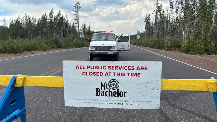
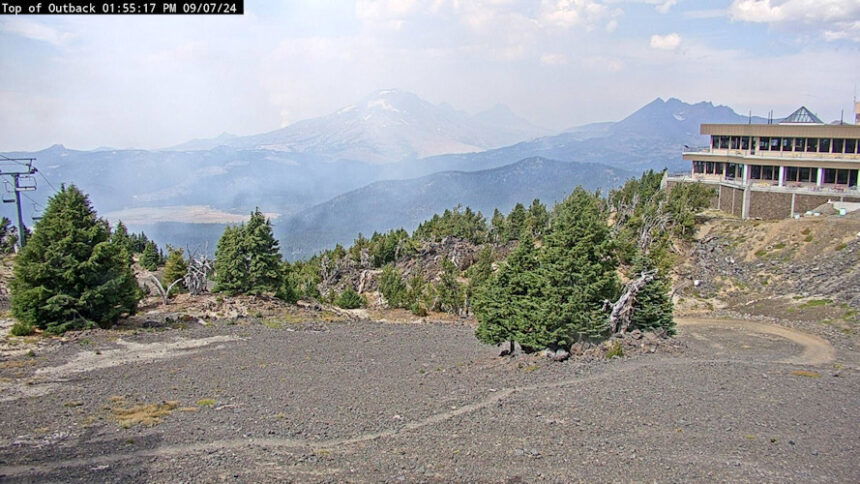
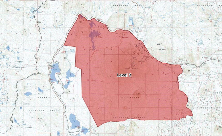
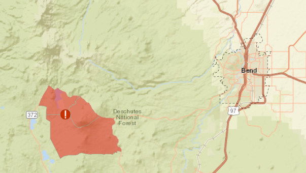
BEND, Ore. (KTVZ) – One of numerous new lightning-sparked fires being tackled around the region Saturday prompted a Level 3 evacuation and closure of Mt. Bachelor resort and much of the surrounding Deschutes National Forest, including Sparks Lake and Devils Lake.
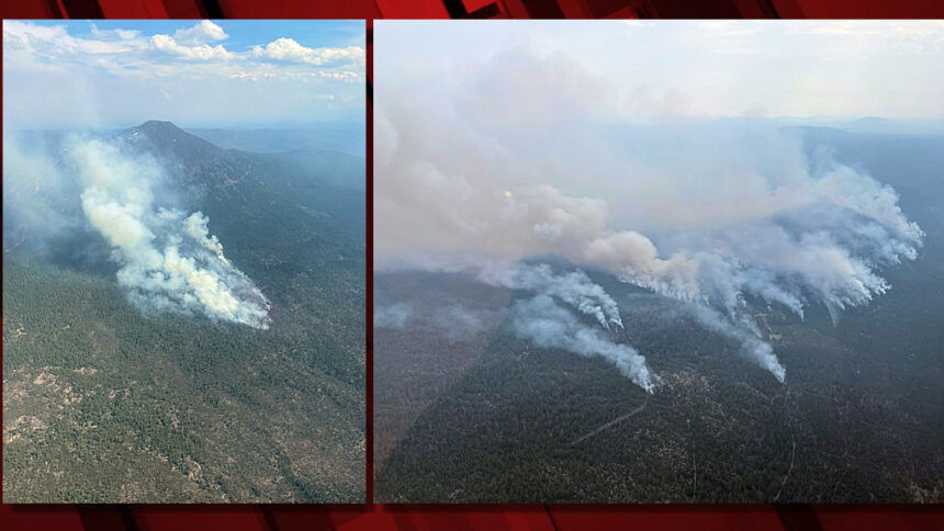
A much larger fire south of Pine Mountain in eastern Deschutes County had its evacuation zone widened late Saturday, as the Firestone Fire grew to 3,000 to 5,000 acres.
The evacuation zone due to the Backside Fire, at 80 acres a mile west of Mt. Bachelor as of Saturday evening, also included the Todd Creek Horse Camp, Quinn Meadow and associated trail systems, officials said in announcements and on the county’s updated emergency evacuation map. The evacuated area appears to about as large as the city of Bend, by comparison.
"Level 3: Means “GO” evacuate now. Leave immediately!" the Deschutes County Sheriff's Office reminded. "Danger to your area is current or imminent, and you should evacuate immediately. If you choose to ignore this advisement, you must understand that emergency services may not be available to assist you further. DO NOT delay leaving to gather any belongings or make efforts to protect your home. This will be the last notice you receive."
Mt. Bachelor announced shortly after 1 p.m. that it was suspending all operations for the rest of the day “due to active fires in the area and extreme fire risk.” They later announced the resort, which hosts a variety of spring, summer and fall activities, will remain closed Sunday due to fire activity in the area. They expect to reopen next Thursday.
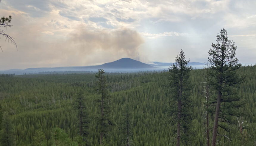
"Very light precipitation accompanied those (storm) systems," fire officials said Saturday evening. "Today, firefighters on the Bend-Fort Rock Ranger District of the Deschutes National Forest responded to approximately 15 wildfires, ranging in initial report size from a quarter of an acre to 150 acres.
"Fires were predominately clustered near the Mt. Bachelor Roadless Area and the eastern edge of Flat Top Butte and East Butte. These wind-driven fires grew at a rapid rate of spread throughout the day, resulting in very large acreage increases."
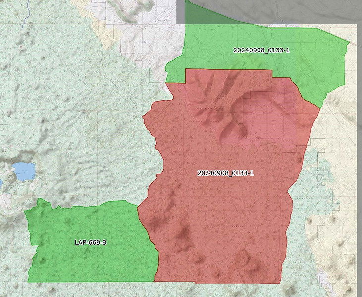
The largest new fire, the Firestone Fire, grew to over 3,000 acres southeast of Newberry Caldera and Paulina Lake on the Deschutes National Forest in eastern Deschutes County, near the Lake County line. A Complex Incident Management Team (CIMT) was being ordered, and Watch Duty quoted a 5,000-acre size Saturday night from the National Interagency Fire Center
It broke out in brush and timber 26 miles east of La Pine on the Deschutes National Forest, southeast of East Butte, Central Oregon fire officials said in a post to their X/Twitter feed Saturday afternoon.
The Forest Service said the fire led to the closure of all trails south of Groundhog Butte, north of South Ice Cave, west of the Sand Spring OHV area and east of Pumice Butte.
Deschutes County Sheriff's Office Emergency Manager Sgt. Nathan Garibay said Saturday night:
Due to the Firestone Fire, the Deschutes County Sheriff’s Office has expanded evacuation notices to the north. Level 3 (Go Now) Evacuations include all areas north of the Lake/Deschutes County Line to Pine Mountain, east of FS 18 (China Hat Rd) and FS 25 (Spencer Wells Rd), west of Moffit Road.
The sheriff’s office also issued Level 1 (Be Ready) evacuations late Saturday that include areas north of Pine Mountain between FS 25 (Spencer Wells Road) and Moffit Road all the way to Highway 20.
Due to an incident near Flat Top Butte in northern Lake County, the Deschutes County Sheriff’s Office also issued Level 1 (Be Ready) for areas west of FS 18 (China Hat Road), north of the Deschutes County/Lake County Line, south of FS 21 Road, and generally southeast of Newberry Caldera.
"Level 1: Means “BE READY“ for potential evacuation. Residents should be aware of the danger that exists in their area, monitor emergency services websites and local media outlets for information. This is the time for preparation and precautionary movements of persons with special needs, mobile property and (under certain circumstances) pets and livestock. If conditions worsen, emergency services personnel may contact you via an emergency notification system."
Earlier info:
Forest Service officials said crews responded to over a dozen fires in the Mt. Bachelor Roadless area. As a result, visitors in the areas of Todd Lake, Elk Lake, Lava Lake and the Metolius-Windigo Trail were advised they could expect to see fire traffic, including aircraft. In areas that did not evacuate, officials said that “visitors should remain aware of surroundings.”
"It’s been a very busy fire year in Oregon," officials said Saturday evening. "Wildland firefighting resources, not only in Central Oregon but throughout the nation, are stretched thin.
"Weather predictions are calling for continued high temperatures, low humidities, windy conditions along with lightning storms, which will lead to additional fire starts. Everyone needs to do their part to avoid additional human-caused starters. Remember, one less spark means one less fire putting our wildland firefighters and our communities at risk."
Visit the official source for wildfire information in Central Oregon at centraloregonfire.org for wildfire updates or follow fire information on X/Twitter @CentralORfire. Call 9-1-1 to report a wildfire. For smoke and air quality information, visit fire.airnow.gov.
New fires also broke out elsewhere in the state, including several in Lake County, the largest as of Saturday evening being the nearly 6,200-acre Bowman Well Fire, according to Watch Duty's report from the National Interagency Fire Center.
Track these and other fires across the region, state and country at https://app.watchduty.org/
Late Friday night, Deschutes County emergency managers issued the Level 2 BE SET notice after several new fires were reported south of Pine Mountain, toward Fort Rock, grouped as Incident 851 (later named the Firestone Fire).
“Campers and those recreating should consider evacuating or should be ready to evacuate at a moment’s notice,” the Deschutes Alert notice stated.
At Mt. Bachelor, a lightning-sparked fire broke out Friday evening in the Northwest area of the resort, bringing Forest Service crews to manage it, Director of Marketing & Communications Lauren Burke said.
Central Oregon fire officials said Saturday morning that crews were responding to about 15 new fire starts, from a quarter-acre to about 150 acres in size, across the Newberry Division of the Deschutes National Forest south of Bend from Friday’s lightning storm, clustered near the eastern edge of Flat Top Butte and East Butte.
--
Other Saturday fire updates:
Rail Ridge Fire:
September 7, 2024-- 9 a.m.
Quick Facts
Cause: Lightning
Acreage: 121,923 (Infrared flight from 9/6 11:05 p.m.)
Containment: 4%
Crews: 7
Engines: 34
Dozers: 11
Aircraft: call when needed/air is clear
Total resources: 387
Headlines
• The Oregon State Fire Marshal (OFSM) Blue Incident Management Team arrived yesterday evening and were in briefed. The Team entered unified command with California Team 10 at 0600 this morning.
• A Red Flag Warning is in effect today until 9:00 p.m. for hot, dry, unstable conditions with the potential for thunderstorms overnight. Gusty, erratic winds and dry vegetation could result in another very active fire day today.
• A PUBLIC MEETING will be held on Sunday, September 8, 2024 at 3 p.m. at the Dayville Community Hall. The meeting will NOT be livestreamed, but presentations will be recorded and posted after the meeting.
• Find current information (including automatically updating acreage) at https://linktr.ee/RailRidgeFire and at the fire's Facebook page.
Closures and Evacuations
Closures: Both the Ochoco National Forest and BLM have implemented partial closures due to the fire. For more details and closure maps, visit the Ochoco National Forest, Malheur National Forest, and BLM webpages.
Evacuations: For the most up-to-date evacuation information, please visit:
-Crook County: Crook County Emergency Management website and Crook County Sheriff’s Office Facebook page.
-Wheeler County: Visit the Wheeler County Sheriff’s Office Facebook page for real-time updates.
-Grant County: Grant County Emergency Management Facebook page.
Operational Update
The control objectives for the Rail Ridge Fire include keeping the fire south of Highway 26, east of Forest Service Road 12, north of County Road 308 (Paulina/Supplee Highway), and west of Laylock Creek (49/63C Road.) Control objectives will be adapted as conditions and resource numbers change.
The Rail Ridge Fire remained extremely active overnight due to increased winds and extremely dry fuels with poor humidity recovery. Night shift firefighters prioritized structure protection on the active southern end of the fire, holding existing containment lines around the fire perimeter, while focusing on areas adjacent to private property and critical infrastructure. Crews completed preparation work around the Alrdrich Mountain Lookout to protect critical infrastructure there.
Today, firefighters will continue to build and improve direct and indirect firelines around the fire perimeter. Structural crews on the north end of the fire will continue to identify and prepare structures directly adjacent to the fire line. On the southern edge, the priorities are to provide point protection and secure structures. Replacement OSFM task forces will arrive today, providing 24-hour dedicated structural coverage.
Weather
Hot, dry, unstable conditions and thunderstorms will affect the fire area Saturday through Sunday. Winds will remain relatively light, although stronger gusts could occur with thunderstorm activity into Sunday morning. Critical fire weather conditions are expected to persist through Sunday, with a return to cooler temperatures and better humidity recovery beginning next week.
--
Firefighters plan to go direct as possible and protect structures on the Wiley Flat and Hawley Ridge Fire
Update September 7, 2024
Fire Information Phone: 530-685-0536 (8 a.m.-8 p.m.)
Email: 2024.wileyflat@firenet.gov
Acres: Wiley Flat – 19,935; 5% contained
Hawley Ridge – 793; 70% contained
Location: Wiley Creek: about 10 miles southeast of Post, Oregon off Highway 380.
Start Date: September 2, 2024 Personnel: 214
Resources: 7 crews |10 engines | 11 dozers | 6 water tenders | 1 skid steers
Highlights: California Team 1 took command of the Wiley Flat and Hawley Ridge fires at 0600 on 9/6/2024. The Hawley Ridge fire remains at 197 acres and is in patrol status.
The Wiley Flat fire pushed northwest crossing the 1690 road into private land near the vicinity of Shotgun Creek increasing the size of the fire by 1,935 acres. Crews continue working on structure protection. Work is continuing to the east to improve fire lines and crews are utilizing the Camp Creek fire scar to their advantage. Aircraft will be utilized when conditions allow. Dozer line at the heel of western edge is remaining secure and crews are working on mop up.
Fire operations will occur this morning in the southeast if test burn is successful. This will help decrease firefighter risk. Otherwise crews will go direct with continued air support.
There is a Red Flag warning for Saturday bringing hot and dry conditions to the fire. Thunderstorms will be moving in the area this evening pushing into the Blue Mountains. There is a possibility for extreme fire activity and new ignitions.
There will be a public meeting at the Post General Store on Monday September 9, 2024 at 6 p.m.
Weather: Temperatures will remain in the 90s with poor RH recovery. Outflow winds may reach up to 40 mph. Forecasted easterly winds expected over fire area will challenge containment lines.
Evacuations: The Crook County Sheriff’s Office has lowered the evacuation level from Level 3 (recommended evacuation) to Level 2 (set for evacuation) from Highway 380 north to SE Puett Road. The area north of SE Puett Road around the perimeter of the fire remains at a Level 3. The area south of Highway 380 has been lowered to Level 1 (prepare for possible evacuation). An evacuation map is available online through the Crook County Emergency Management Office website.
Importance of Fire Prevention: All public lands in Central Oregon, including the Ochoco National Forest, are in Stage 2 Public Use (Fire) Restrictions. All open flames, including woodstoves and charcoal briquette fires, are prohibited. In times of high fire danger, it is crucial for everyone to follow prevention measures to avoid additional strain on overburdened resources.
Fire Restrictions and Closures: The Ochoco National Forest has implemented a forest closure for the eastern portion of the Paulina Ranger District. The Bureau of Land Management has issued a temporary closure for portions of public lands in Crook and Grant Counties.
More Information:
InciWeb: https://inciweb.wildfire.gov/incident.../orocf-wiley-flat
Facebook: Facebook.com/Wiley Flat Fire
Central Oregon Wildfire Information: https://centraloregonfire.org/
--
| SHOE FLY FIRE Evening Update: September 7, 2024 |
Phone: (541) 362-4119
Email: IMT1.FireInfo@ODF.oregon.gov
FIRE AT A GLANCE
Total Size: 25,142 acres
Total Containment: 8%
Cause: Lightning
Estimated Cost: $2,237,816
County Evacuations
Wheeler County Sheriff’s Office has
issued evacuation notices, info
available here:
https://tinyurl.com/RAPTOREvacuation-Info
Road Closures
For road closures, visit:
https://www.tripcheck.com
Fire Restrictions
ODF:
www.oregon.gov/odf/fire/pages/restrictions.aspx
BLM:
www.blm.gov/programs/publicsafety-and-fire/fire-andaviation/regional-info/oregonwashington/fire-restrictions
All Resources
Hand Crews: 33
Engines: 40
Water Tenders: 12
Dozers: 16
Helicopters: 7
Total Personnel: 936
ODF Incident Commander:
Joe Hessel
Incident Management Team 1
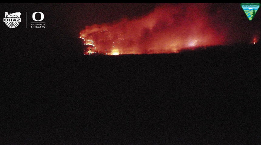
Windy conditions prompt additional spot fires, firefighters catch and line them Saturday
MITCHELL, Ore. – Firefighting resources on the Shoe Fly Fire continued to be challenged by spot fires today, beginning as early as 6 a.m. Three new ones were found, two on the southwest side and one on the northeast corner. Firefighters spent the day lining these fires and were able to get all three of them circled with bulldozer line. Mop-up operations followed, which will continue into this evening.
Across the rest of the fire, resources continue to hold and improve lines and push forward on mop-up operations, which will continue to add toward overall containment. Tonight, crews will continue this work.
Weather systems brought short bursts of showers throughout the middle of the day, but not enough rain to make a difference on the fire. Windy conditions are expected to persist, as a Red Flag Warning issued by the National Weather Service is now extended to 11 p.m.
Temperatures heated up in the afternoon and relative humidity dropped, however chances for precipitation continue tomorrow and a predicted cold front that is expected to move into the area early next week. A chance of thunderstorms remains in the forecast for tomorrow and firefighters are ready to respond to any new reports of fire in the event of lightning strikes.
Three Oregon State Fire Marshal (OSFM) structural task forces remain engaged protecting structures near the fire. Overnight, structural firefighters assessed homes on the north side of Highway 26 in Mitchell and created mitigation plans, which day shift task forces began carrying out on Saturday. This work is precautionary and will help to protect structures if the fire moves closer toward town. This is a coordinated effort between Wheeler County Fire Defense Board, OSFM and Team 1 operations.
Evacuation notices for residents around the fire continue to be evaluated by the Wheeler County Sheriff, Wheeler County Fire Defense Board Chief, and Team 1 Operations personnel. More information on current evacuations is available at https://tinyurl.com/RAPTOR-Evacuation-Info
While there are no current road closures due to the Shoe Fly Fire, other fires nearby may be impacting travel. Check https://tripcheck.com/ for current closures and potential delays.
--
Red Fire
News - 09/07/0024 - 11:40
Size: 1,289 acres Location: 5 miles west of Crescent Lake Junction, OR County: Klamath
Start Date: July 17, 2024 Cause: Lightning Containment: 0% Total Personnel: 97
Activities – There was increased fire activity yesterday due to critical fire weather conditions and instability from a storm cell that moved over the area in the early evening. An overnight infrared flight mapped the fire at 1,289 acres. The fire is backing downslope into the vicinity of the Whitefish Creek Trail. Today, firefighters will continue to monitor and secure the area along the trail. Structure protection equipment remains in place along Crescent Lake. The Red Fire and Willamette Complex Fires - South incident management teams and forest leadership for the Deschutes and Willamette National Forests are coordinating, and we are monitoring the nearby 208 Fire to the west of the Cascade crest.
Strategy – A full suppression strategy is being implemented utilizing indirect tactics, shaded fuel breaks, structure protection equipment, trails, and hose lays. When the fire started, an assessment by the initial attack incident commander, local fire managers and forest staff determined the risk to responders was too great to continue with direct attack due to a lack of escape routes and safety zones, snag hazards, and firefighter safety issues in the remote location. Firefighters are continually reevaluating the safest, most effective suppression strategy based on changing weather, fuel conditions, and fire behavior. Firefighter and public safety remain the incident management team’s highest priority in managing this fire.
Closures – To provide for the safety of firefighters, equipment operators, and the public, the Deschutes National Forest emergency closure around Crescent Lake and in the Diamond Peak Wilderness is still in effect. Forest Service Road 60 is closed, and road guards have been posted for public safety. The emergency closure is being reevaluated daily as conditions continue to change. More closure information is available at: https://www.fs.usda.gov/alerts/deschutes/alerts-notices/?aid=89091.
The Pacific Crest Trail (PCT) is closed from north of Windigo Pass (Mile 1883.5) to Highway 58 (Mile 1909.5). The previous PCT detour around the fire has been decommissioned as of noon on September 4. Currently there is not a detour around the closure. A map displaying the PCT closure can be viewed on the Pacific Crest Trail Association’s (PCTA) website at: https://closures.pcta.org/closure/Mr02blDvEwX1SJ9h1H49.
The 2024 season for commercially harvesting Matsutake mushrooms opened for the Deschutes National Forest is open and will close November 4, 2024. The emergency fire closure impacts certain harvesting locations.
Incident Weather, Fire Behavior, and Smoke – Temperatures and relative humidity will again reach critical values today. Temperatures will be 80 to 85 degrees and relative humidity is forecasted to drop below 20% during the day. There is a threat of thundershowers again this afternoon with limited rainfall and gusty outflow winds. As warm and dry weather prevails, vegetation moisture will continue to drop making more fuel available and increasing surface fire activity. Active surface fire spread can be expected. Lower temperatures and high relative humidity are expected tomorrow with a cooling trend beginning on Monday.
Evacuations – The WILDFIRE! Level 1 – BE READY to Evacuate notice issued by Klamath County Emergency Management for Crescent Lake, Odell Lake, and Crescent Junction areas remains in effect (INCENDIO FORESTAL! Nivel 1 - ESTÉ PREPARADO para evacuar de las siguientes zonas: Crescent Lake, Odell Lake, Crescent Junction). Visit www.klamathcounty.org/300/emergency-management for more information or to sign up for alerts.
Fire Restrictions – Stage 2 Public Use Fire Restrictions – which prohibit open fires, including in developed campgrounds – remain in effect for the Deschutes National Forest. The Industrial Fire Precaution Level is currently Level III “Partial Shutdown.” Visit fs.usda.gov/detail/deschutes/home/?cid=stelprdb5297376 for more information.
--
Copperfield Fire
Morning Update
SEPTEMBER 7, 2024 | Fire information resources: |
| FOR IMMEDIATE RELEASE | Inciweb: Copperfield Fire - OR98S Facebook: Copperfield Fire 2024 Email: CopperfieldFire2024.Info@gmail.com Phone: 541-233-6967 (8 am to 8 pm) |
FIRE AT A GLANCE
Estimated Size: 3,822 acres
Containment: 57%
Cause: Under Investigation
Estimated Cost: $6.1 million
Primary residences destroyed: 8
Other buildings destroyed: 22
Evacuations
Klamath County Emergency
Management
Road Closures
For road closure updates, visit:
https://www.tripcheck.com
Resources
Hand Crews: 21
Engines: 27
Water Tenders: 15
Dozers: 6
Helicopters: 7
Other Equipment: 8
Total Personnel: 668
ODF Incident Commander
Tyler McCarty
Chiloquin, Ore. – Work done on the Copperfield Fire proved successful at holding containment through Red Flag warnings yesterday. During the night shift the IR flight detected a single hot spot which surfaced with the increase of wind. Night crews were able to focus efforts on the heat. Crews continued their success in expanding the perimeter depth of the fire in previously burned areas (black line) that are now cold and being mopped up. Containment increased to 57%.
Today’s weather calls for slightly cooler temperatures and lighter winds. The crews will take advantage of these conditions to continue their push deeper into the black areas around the fire perimeter. Focus will be on the west end, near Corbell Butte.
With the thunderstorms in the area yesterday some crews may be used for initial attack for any new fire starts from lightning. In addition, some crews will begin preparing for transition, demobing to be available for other new fires starts throughout the state. Evacuation levels will continue to be evaluated with the increase of the fire containment. Evacuation levels are determined by the Klamath County Sheriff's Office in conjunction with fire officials and agency administrators. Current evacuation areas and levels can be found at https://www.klamathcounty.org/300/Emergency-Management
