Winds test, lines hold on Little Lava Fire; Bachelor Complex nearly 2/3 contained; Bingham, Rail Ridge fire updates
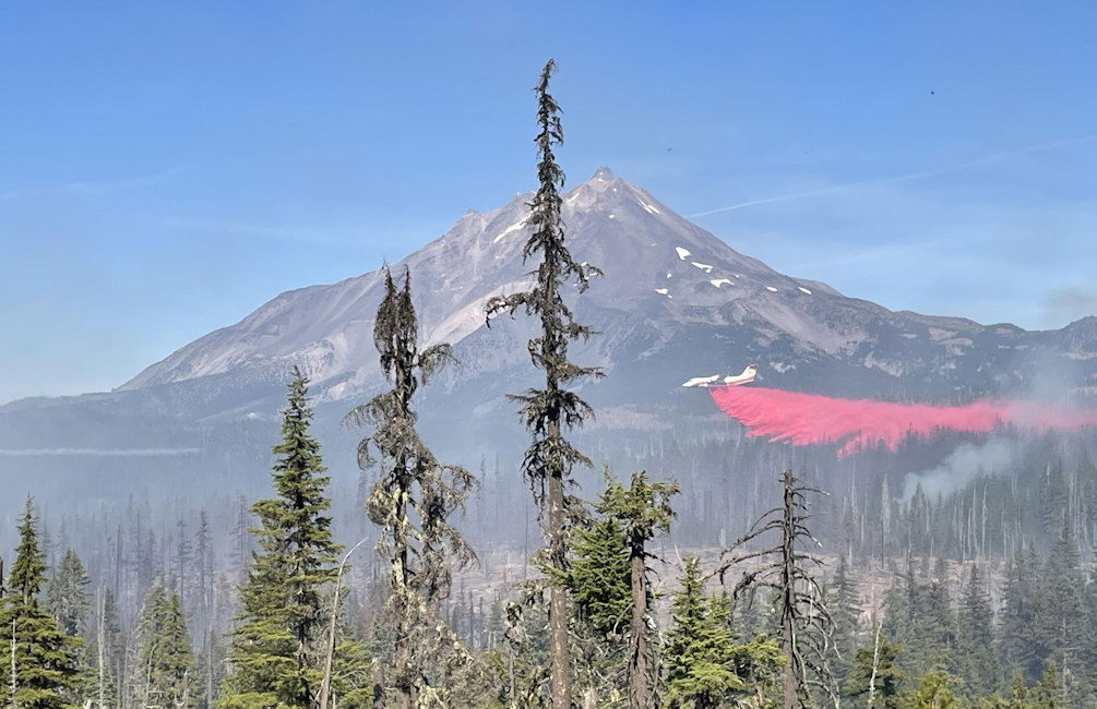
BEND, Ore. (KTVZ) – All of the containment and control lines on the Little Lava Fire held in Friday’s strong winds and the Bachelor Complex is now nearly two-thirds contained, Deschutes National Forest officials said Saturday.
The 12,120-acre group of fires sparked by lightning nearly a month ago has burned 12,120 acres and is 63% contained, with 70 personnel still working on the Little Lava Fire 20 miles southwest of Bend.
“Firefighters achieved their goal of holding the fire west of the Edison No. 3 trail on the northern flank, stopping new growth to the east,” Saturday’s update stated.
“Aircraft supported ground resources throughout the day by dropping water to help hold the control line along the Edison No. 3 Trail, which was secured over the pats couple days by strategic burning operations,” they added.
With more mild, warm weather predicted over the next week, officials said “the fire is expected to continue burning slowly north, with low to moderate intensity.”
--
Bingham Fire Update for Saturday, October 5, 2024
Marcel Potvin, Incident Commander
Start date: Sept. 30, 2024
Location: Detroit Ranger District, Willamette National Forest
Cause: Undetermined
Fire size: 183 acres
Full Suppression
Personnel: 204, including 8Crews, 7 Engines, 2 Dozers
The Bingham Fire, located east of the Bingham Ridge Trailhead near Marion Forks, was reported on the evening of Sept. 30, 2024. The fire is burning partially within an older fire scar along the Bingham Ridge Trail that extends into the Mount Jefferson Wilderness area. Complex Incident Management Team (CIMT) California Team 1 will arrive today for an in brief.
LEVEL 3: GO NOW! Evacuation Alerts have been issued by the Linn County Sheriff’s Office for a large area of the Mount Jefferson Wilderness. Additionally, LEVEL 2: GET SET Evacuation Alerts have been issued for the area around Marion Forks Campground, and Marion Forks Fish Hatchery. The Level 2 evacuation area also extends along Highway 22, to ½-mile west of Highway 22, from Pamelia Road (NFS Road 2246) south to Parrish Lake Road (NFS Road 2266). Please refer to the Linn County Wildfire Map for more information: https://tinyurl.com/LinnCoFireMap. Highway 22 remains open at this time.
The Willamette National Forest issued an updated formal closure yesterday in the same footprint of the Level 3 Evacuation here: https://tinyurl.com/26jpr9a6. A large evacuation area like this is necessary to give wildfire response teams enough space to safely travel to and fight the fire, as crews will be on road systems, trails, and air assets may be utilizing nearby water sources. The fire itself is much smaller than the evacuation area. The Pacific Crest Trail (PCT) through the Mount Jefferson Wilderness is expected to remain open. The trails and roads west of the highway are closed from Pamelia to Big Meadows Loop/Turpentine Loop area. Hunting season will be opening today, and the forest will work with Linn County Sheriff to reduce closure areas as soon as it is safe to do so.
Firefighters are working as direct as possible to the fire’s edge. In the last four days, crews have been working to complete initial primary line construction on the southern side of the fire to the wilderness boundary. Contingency lines have gathered equipment and may be starting construction soon. There is a plan being developed for protecting structures around Marion Forks and Independence Prairie.
WEATHER:
SAFETY: Members of the public are encouraged to heed local evacuation orders issued by the county sheriff’s office and emergency notification systems. Know the Ready, Set, Go levels and make appropriate preparations. READY your belongings; SET your things at the door or prepack them in your car; GO and leave immediately.
Linn County Resources
Fire Evacuation & Status Live Updates: https://www.linnsheriff.org/wildfire_live_updates/
Wildfire Preparedness & Resources: https://www.linnsheriff.org/wildfire-recovery/
Willamette NF Resources
Detroit Ranger District Front Desk: 503-854-3366
https://www.facebook.com/willamettenf
Bingham Fire Information
Email: 2024.bingham@firenet.gov
Inciweb: https://inciweb.wildfire.gov/incident-information/orwif-bingham-fire
--
Rail Ridge Fire Update
October 05, 2024
Central Oregon Wildfire Information: centraloregonfire.org
Email: 2024.railridge@firenet.gov – Phone: 541-208-7111
Social Media, Evacuation and Closure Information: https://linktr.ee/RailRidgeFire
Acres: 168,002 – Containment: 89% – Detection: 09/02/24 – Cause: Lightning – Personnel: 601
Forest closures around the Rail Ridge and Crazy Creek Fires remain in place. A map with the ODFW hunting management unit areas overlaid with the closure area and fire footprint can be found at: https://linktr.ee/RailRidgeFire. For the safety of firefighters and forest visitors it is of the utmost importance that the closure areas remain in place at this time. Potential hazardous circumstances associated with the area include hazard trees and ground stability in recently burned areas, continued burning within the interior of the fire, firefighters and apparatus traveling and working in the area and there is no means to quickly notify public in the fire area of emerging safety concerns.
Operational Update
Yesterday, the passing cold front brought high winds across the fire area which tested the established containment lines. No significant growth was reported, and current containment lines held. Interior pockets of fuels did become active during the afternoon, and the westerly side of the fire in the Black Canyon Wilderness continued burning through the Honeymoon Creek area. Tactical firing operations were completed to prevent fire from advancing toward Wolf Mountain Lookout and the communication site. Early in the day a smoke column west of the Rail Ridge Fire was reported. Local resources responded and found and unburned island of fuel within the Crazy Creek Fire footprint to be burning and was suppressed quickly.
Last night’s relative humidity recovery is a welcome start to the weekend for firefighters. Coupled with predicted lighter winds, fire activity is expected to be minimal. Interior flare-ups and additional acres of burning in the Black Canyon Wilderness area will continue to produce smoke. Firefighters will continue to strengthen contingency control lines and containment around the Black Canyon Wilderness. As needed, tactical firing operations will be used to add depth to lines that are already in place. Suppression repairs are ongoing with resource advisors, and mop-up and patrolling will continue around the contained portions of the fire.
Weather
Terrain driven winds around 10mph are expected over the fire area with mostly sunny conditions and temperatures in the mid to upper 60’s. Relative humidity will again recover tonight to an estimated 75-80% but will dip into the 20-25% range in the afternoon today.
Evacuations
Level 1 evacuations in Grant County were dropped this week and the level 2 evacuations remain. Wheeler County evacuation remain the same.
For Current Evacuation Levels all affected counties, please visit: https://linktr.ee/RailRidgeFire
Closures
The U.S. Forest Service and Bureau of Land Management have implemented closures for the Rail Ridge Fire. For more details and closure maps, visit https://linktr.ee/RailRidgeFire
Related Links:
