Power lines sparked 13 Santiam Canyon fires; roundup of latest fire info
At least 8 dead, a dozen missing, more than 1,600 homes destroyed, 1,500 other structures
SALEM, Ore. (AP) — A fire incident report says downed power lines sparked at least 13 fires during a period of high winds last week between two Santiam Canyon communities that were devastated by flames.
The report from the Northwest Interagency Fire Coordination Center that was written last Thursday says the fires ignited between Mehama and Detroit, east of Salem during peak winds on Labor Day (Monday, Sept. 7).
The report doesn’t say to what extent those fire starts affected a larger, separate blaze that started Aug. 16.
That wind-driven fire, called the Beachie Creek Fire, swept through a canyon early on Sept. 8 and wiped out the towns of Detroit, Gates, Mill City and Idanha. Its cause is still under investigation.
The Oregon Public Utility Commission told local media Tuesday that it had no information that attributed a “specific wildfire to any specific Oregon utility.”
Meanwhile, a Salem man has been formally charged with setting an arson fire in southwest Oregon that damaged 15 properties.
According to court documents, 41-year-old Michael Jarrod Bakkela started a fire behind a home in Phoenix on Sept. 8 as strong, dry winds pummeled the state.
He is not being charged with starting the much larger Almeda Drive fire in Ashland, which began on the same day.
Bakkela is being held on an enhanced bail of $5 million in Jackson County and faces 32 criminal counts, including two counts of first-degree arson, 15 counts of criminal mischief, 14 counts of reckless endangerment and one count of methamphetamine possession. He was scheduled to be arraigned later Wednesday.
State officials said Wednesday the death toll from the devastating fires remains at eight, with a dozen people still missing and nearly 4,000 evacuees still in shelters. The blazes have destroyed more than 1,600 homes and nearly 1,500 other structures.
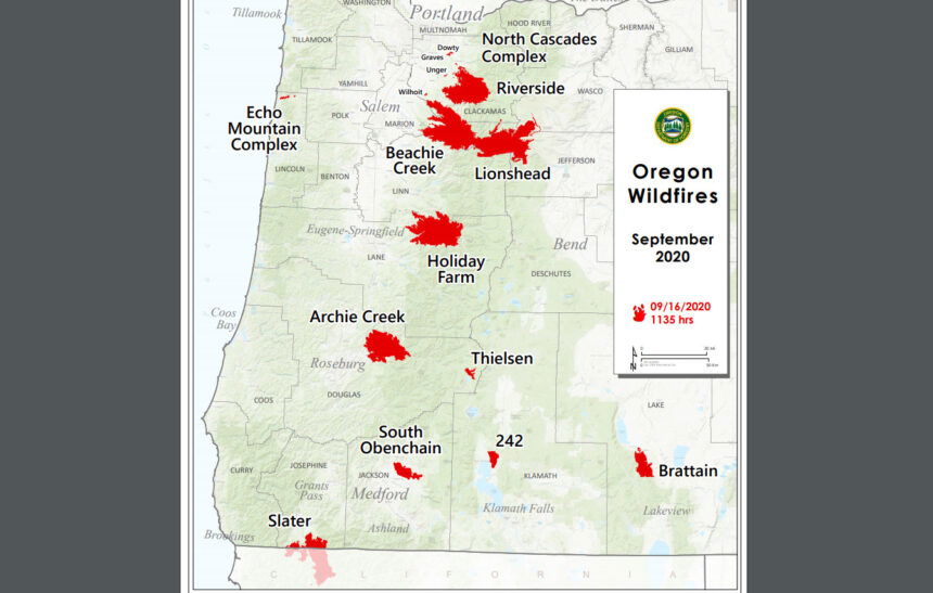
ODF Fire Report: Wednesday, Sept. 16:
SALEM, Ore – ODF is closely monitoring 12 major fires in Oregon. (see table below for details). Fires are removed from the list when they are 100% lined and fire managers are confident in their progress toward containment.
There are more than 6,000 personnel assigned to these fires from across the nation and Canada. This doesn’t include the many of the government emergency response employees, landowners, forestland operators, and members of the community who are contributing to the fight in whatever way they can.
About 1 million acres have burned in Oregon since the start of this year, which is nearly double the 10-year average of approximately 557,811.
| Fire name | Acres burned (estimated) | Containment | Location |
| Beachie Creek | 190,911 | 20% | 15 miles N of Detroit |
| Lionshead | 183,744 | 10% | 20 miles W of Warm Springs |
| Holiday Farm | 167,422 | 8% | 3 miles W of McKenzie Bridge |
| Riverside | 135,956 | 3% | 2 miles SE of Estacada |
| Archie Creek | 125,498 | 20% | 20 miles E of Glide |
| Brattain | 34,155 | 15% | 8 miles S of Paisley |
| S. Obenchain | 32,513 | 25% | 5 miles E of Eagle Point |
| Slater | 30,998 in Oregon | 10% | SE of Cave Junction (also in No. California) |
| Two Four Two | 14,536 | 21% | W/NW of Chiloquin |
| Thielsen | 7,778 | 1% | E of Diamond Lake |
| Echo Mtn. Complex | 2,552 | 40% | 4 miles NE of Lincoln City |
| North Cascade Complex | 2,315 | – | Multiple locations in ODF’s North Cascade District |
Two Four Two Fire
September 16, 2020 10:00 a.m.
Email contact—twofourtwofire.information@gmail.com
Public Information Line: (541) 846-8174
Inciweb—https://inciweb.nwcg.gov/incident/7159/
Facebook—https://www.facebook.com/TwoFourTwoFire
Size: 14,475 Acres
Containment: 21%
Start Date: Sept. 7, 2020
7:00 p.m.
Expected
Containment Date: Sept. 25, 2020
Location: Northwest of Chiloquin, Oregon
Cause: Unknown
Est. Cost: $3.9 million
Personnel: 462
Resources: 9 hand crews
29 Engines
12 Dozers
13 Water Tenders
Aircraft: 4 Helicopters
Evacuations: None
Structures
Threatened: 0
Structures
Damaged: 72
Structures
Destroyed: 36
Closures: None
Fire Summary:
There is a Red Flag Warning for our area for gusty winds and low
relative humidity today. The weather continues to be dry and we are expecting to see gusts up to 20 mph today. In anticipation of the winds,
crews continue working hard to eliminate hot spots along the perimeter of
the fire.
Yesterday there were two new fire starts within the surrounding
area of the Two Four Two Fire. The Cattle Fire is east of the Two Four Two
Fire in the Pine Ridge Estates. It burned in grass and grew to 5 acres. The
second start, named the Dam Fire, was off of Twin Rivers Road. That fire
grew to 2.25 acres. Multiple engines were pulled from the Two Four Two
Fire line to assist Chiloquin Fire Department and local resources with these
new fires. Crews will continue mop up operations and patrol both of these
fires today. Both fires are under investigation.
Highway 97 will have areas of traffic control points so crews can
fall hazard trees. The highway will remain open during this work.
Safety remains our top priority. This includes trying to prevent
COVID-19 infections. Personnel are following the Center for Disease Control guidelines. We continue to limit personal contact within fire camp and
the community. The fire camp continues to be closed to the public and
media.
BRATTAIN FIRE UPDATE
Wednesday, September 16, 2020 @ 9 AM
Yesterday:
The most significant fire growth continues to be on the northwest perimeter with active movement north and west overnight. To combat this, 3 dozers, numerous engines, and 1 hotshot crew were dispatched to this area. Patrols continued work in the northeast and east to reinforce black line and protect property. Dozer work in the south tied in with Forest Road 3510 and existing black line from previous fires this season, making continued progress with containment. A virtual public meeting video from last night is available on the Fremont-Winema National Forest Facebook page.
Today:
Warm and dry conditions coupled with strong, gusty winds will again present challenges. A Red Flag Warning is in effect from 1-8 PM. Additional aircraft and hotshot crews are anticipated. In the northwest, work will include establishing containment lines using roads, dozer line construction, natural breaks and old burn scars. Firefighters in this area continue to work around the clock. Forest Road 3510 and Clover Flat Road are being prepped as holding lines on the south and southwest perimeters. Additional fire vehicles and equipment will be present in the area. Please use caution when traveling on Hwy 31. Direct fire attack tactics will be implemented as soon as weather conditions permit to protect private property, critical infrastructure and natural and cultural resources.
Evacuations:
The Lake County Sheriff’s Office has issued the following evacuation notices:
Level 3 (Go) – Hwy 31 from Summer Lake Store south to include all of Paisley, south on Highway 31 to Valley Falls/the junction with Hwy 395. All of Clover Flat Road from the intersection with Hwy 31 (Beachler’s Corner) south to Valley Falls. West of Hwy 31 west of Forest Road 28
Level 2 (Set) – From Summer Lake Store north along Hwy 31 to the top of Picture Rock Pass
Level 1 (Ready) – Abert Lake area southeast on US 395, south on Hwy 31 to Chandler State Park approximately 5 miles south of Valley Falls.
The Red Cross has an evacuation area at the Lake County Fairgrounds in Lakeview (1900 North 4th St.)
Forest Closure:
From Forest Road 29 southeast to Forest Road 3510 and the 28 Road east, all National Forest System lands and facilities are closed per Forest Closure Order 06-02-03-20-03. Forest Road 3315 is closed; the 28 Road is open.
Summary:
The Brattain fire started on September 7th, 2020 and is currently burning on the Paisley Ranger District of the Fremont-Winema National Forest. The Eastern Area Incident Management Team is currently managing the fire. Firefighting crews continue to operate on a 24-hour schedule and are battling winds, extremely dry conditions and shortages of firefighting resources.
SIZE: 40,316 acres
CONTAINMENT: 17%
CAUSE: Human
PERSONNEL: 359
FIRE INFORMATION:541-947-6243
2020.brattain@firenet.gov
INCIWEB:inciweb.nwcg.govsearch “Brattain Fire”
Facebook:www.facebook.com search:Fremont-Winema National Forest @R6FWNFSouth Central Oregon Fire Management Partnership @SCOFMPFIREINFO
LEVEL 3 EVACUATION
Hwy 31 from Forest Rd 29; Paisley; south on Clover Flat Road (both roads) to Valley Falls; Forest Rd 29 north to Summer Lake Store
LEVEL 2 EVACUATION
Hwy 31 from Summer Lake Store north to Picture Rock Pass
LEVEL 1 EVACUATION
Abert Lake southeast on US 395 south on Hwy 31 to Chandler State Park
The Red Cross has an evacuation area at the Lake County Fairgounds.
SAFETY: Anticipate congestion on Hwy 31 due to fire traffic. Please use caution and avoid the area.Temporary Flight Restrictions are in effect. Avoid drone use and report drones to law enforcement.
| Lionshead Fire Update – Wednesday, September 16, 2020 – 9:00 a.m. |
| Start Date: 8/16/2020 | Approx. Size: est. 183,744 ac. | Resources on the Fire: | Cooperating Agencies: |
| Cause: Lightning | Containment: 10% | 31 Crews | Marion Co. Sheriff |
| Incident Commander: | Total Personnel: 1113 | 31 Engines | Linn Co. Sheriff |
| Noel Livingston Pacific Northwest Team 3 | Approx. Distance: 14 miles west of Warm Springs | 8 Dozers 28 Water Tenders 11 Helicopters | Jefferson Co. Sheriff Deschutes Co. Sheriff |
Weather and Fire Behavior: Well over one million acres are currently experiencing fire in the Pacific Northwest, mostly in large timber through the Cascades. The scale of this situation means that full perimeter containment or control will take time and help from seasonal weather. Lower temperatures, lighter winds, and higher humidity has aided firefighting efforts. Today conditions will be very similar to yesterday, with light variable winds, temperatures in the upper 60s and mid-70s, and 30 – 35% relative humidity. Fire activity should be moderated today across most of the fire and some rain is still expected Thursday.
Yesterday: Yesterday, additional fire line along the east/southeastern portion of the fire was declared contained. When fire line is called “contained,” it means control line has been established which can reasonably be expected to stop the fire’s spread. Strategic firing operations on the Warm Springs Reservation last night were very successful, helping to secure the northeastern flank of the fire. Firefighters also dealt successfully with spot fires near the base of Sisi Butte. Firefighters focused attention on protecting structures and constructing containment line.
Today’s Activities: Aviation assets will likely be grounded by smoke again today, but firefighting efforts are on a positive trajectory. Some mop-up work remains in the Stahlman neighborhood and south of Detroit Lake, and crews will be removing fire-weakened trees in Detroit for the safety of firefighters and residents. To the northeast, crews will continue to extend the containment line established over the last few days on the Warm Springs Reservation, bringing it westward towards the Mt. Hood National Forest. As weather and expected precipitation continue to mitigate fire behavior, firefighters will have more opportunities to safely “go direct,” digging fire line along the fire’s edge instead of building “indirect line” away from the fire’s perimeter. Fire managers will continue to coordinate closely with the Confederated Tribes of the Warm Springs and with personnel on neighboring incidents on firefighting efforts.
Later this week, Pacific Northwest Team 3 will be transferring command of the Lionshead Fire to Rocky Mountain Team 1.
Evacuations: Level 1 and 2 Evacuation Notices remain in place on the Warm Springs Reservation and can be monitored on Warm Springs Police Facebook page. Up-to-date statewide evacuation information can be found at the https://www.oregon.gov/oem/emops/Pages/RAPTOR.aspx.
Closures: Roads and trails on the southwest portion of the Warm Springs Reservation near the fires remain closed for public safety. Forest closures are in place for Deschutes, Mt. Hood and Willamette National Forests: Deschutes NF Alerts Willamette NF Alerts Mt. Hood NF Alerts
FOR ADDITIONAL FIRE INFORMATION: Fire Information: 971-277-5075
TripCheck: https://www.tripcheck.com/
Inciweb: https://inciweb.nwcg.gov/incident/7049/
Facebook: www.facebook.com/LionsheadFire
Email: 2020.lionshead@firenet.gov
Beachie Creek Fire Update for Wednesday, September 16, 2020
Start date: Aug, 16, 2020 | Location: Santiam Canyon near Detroit, OR, Marion County | Cause: Unknown |
| Fire size: 191,238 acres | Air Assets Assigned: 7 | Total personnel: 530 |
Salem, Ore. –Firefighters continue to make good progress securing the perimeter of the Beachie Creek Fire. As a result of their efforts, the fire is 20% contained. Following an extensive assessment by crews, fire officials determined that 470 residences, 35 commercial structures, and 783 minor nonresidential structures were destroyed by the fire. Additionally, 46 residences, 5 commercial structures, and 83 minor nonresidential structures were damaged.
Crews and heavy equipment continue to connect and strengthen control line on the west and northwest sides of the fire. Firefighters continue to work with landowners on the southeastern perimeter to secure control lines. The increased acreage in fire size is not due to fire spread over the past 48 hours but because aerial assessments are being completed, providing more accurate measurements and improved mapping. Transfer of command from Northwest Incident Management Team 13 to Southwest Incident Management Team 2 will take place this evening. The teams have been working closely over the last 24 hours to ensure a seamless transition of command.
The Beachie Creek Fire and the Riverside Fire remain about one mile apart. Officials from nearby fires are coordinating strategies to minimize fire growth and stabilize incidents. Extremely dry vegetation and a lack of natural holding features in the Table Rock Wilderness and surrounding areas mean it is still possible the fires could burn together. Based on current weather, it is anticipated that a future merger would not result in dynamic fire behavior as seen last week.
Fire officials are working closely with the Marion County Sheriff’s Office, ODOT and the Oregon State Police to coordinate recovery efforts along the Santiam Canyon. Currently 5,845 structures are at Level 3 evacuations and another 3,961 are in level 2 evacuations. It is imperative to protect first responders and communities that everyone heeds fire and law enforcement road closures and evacuations. Anyone who enters the fire perimeter jeopardizes firefighting and rescue operations, puts lives at risk, and potentially increases the time it will take to return residents to their communities.
WEATHER: Wednesday will begin with another fog layer likely to dissipate by mid-day. It is expected to be hotter and drier today with temperatures in the 70s, forecasted minimum relative humidity of 35-50 percent across the fire, and as low as 25 percent on ridges. This could result in an increase in fire behavior. A low pressure system bringing rain to the area is forecasted for Thursday night and Friday.
SAFETY: Members of the public are encouraged to heed local evacuation orders issued by the county sheriff’s office and emergency notification systems. Know the Ready, Set, Go levels and make appropriate preparations. READY your belongings; SET your things at the door or prepack them in your car; GO and leave immediately.
SMOKE: Smoke will continue to be heavy across the area of the Beachie Creek Fire again today. This will lead to “unhealthy” and possibly “hazardous” conditions. Individuals with respiratory issues may find themselves affected by the intense smoke. Smoke levels can change rapidly depending on weather. Check current conditions on DEQ's Air Quality Index or by downloading the free OregonAIR app on your smartphone.
CLOSURES: The entire Willamette National Forest is closed to all recreation including campgrounds, trails, days use areas, and boat ramps. Roads on the forest are closed to the public unless being used to evacuate. Bureau of Land Management (BLM) lands in the vicinity of the fire and State lands managed by Oregon Department of Forestry (ODF) including the Santiam State Forest are also closed to the public. Go to InciWeb (link below) for more information about closures in the area.
| Public information: Facebook: facebook.com/BeachieCreek E-mail: BeachieCreek@gmail.com Phone: 541-583-0526, 8 a.m. to 8 p.m. | Inciweb https://inciweb.nwcg.gov/incident/7001/ Oregon Smoke Blog http://oregonsmoke.blogspot.com/p/air-quality-now.html |
Holiday Farm Fire Information
September 16, 2020
Oregon Department of Forestry IMT 3
Link Smith, Incident Commander
Oregon State Fire Marshal's Red Team
Ian Yocum, Incident Commander
Holiday Farm Fire Information: (541) 357-9729 (7am—10pm)
Lane County Non-Emergency Call Center: 541-682-3977 (7am-10pm)
Linn County Non-Emergency Call Center: 541-812-2260
https://inciweb.nwcg.gov/incident/7170/ email: holidayfarmfireinfo@gmail.com
Estimated Size: 170,637 acres
Containment: 8%
Start Date/Time: 9/7/2020 8:20 p.m.
Expected
Containment Date: 10/29/2020
Location: Lane County
Cause: Unknown
Personnel: 783
Assigned Resources:
Hand Crews: 22
Engines: 51
Dozers: 31
Water Tenders: 17
Other Heavy
Equipment: 2
Assigned Aircraft: 7
Structure Task Forces: 6
Injuries: 0
Structures
Threatened: 15,254
Structures--
Destroyed: 503
Failed: 9
Damaged: 28
No Damage: 230
Evacuations:
Level 1 (READY), Level
2 (SET) and Level 3
(GO!) are in effect.
Springfield, Ore. –The overnight infrared flight mapped the Holiday Farm Fire’s footprint at over 170,000 acres. The fire’s perimeter measures more than 260 miles or roughly Portland to Medford.
The suppression strategy uses a combination of roads, ridges and hand line to control the fire’s spread. Across the lengthy perimeter of the fire crews are making steady progress. Equipment operators are widening existing roads, building dozer lines and removing trees to create solid control lines. Hand crews are following up, connecting control features and completing burnout operations to remove fuels between the main body of the fire and control lines.
Structural firefighters continue to aggressively extinguish hot spots in and around homes, clearing 100 feet around structures. The focus today remains on mopping up around homes from Vida to Rainbow. Protection efforts also remain in and around homes in the Deerhorn Road and Greenpasture Road areas.
The Urban Search and Rescue Team has completed 770 structural evaluations in the fire area. The team started at the eastern edge of the fire in the community of Rainbow and have been working west down the Highway 126 corridor. The team expects to assess structures in the community of Blue River today. The team has assessed about 75 percent of the 1018 structures in the fire area. Structures include commercial buildings, residences and outbuildings.
As of today, the USAR team has identified:
• 503 have been destroyed (complete destruction of structure)
• 9 failed (high risk, may be subject to sudden collapse)
• 28 damaged (medium risk, structure is moderately damaged)
• 230 no damage reported (low risk, low probability of future collapse)
The Incident Meteorologist forecasted that today’s weather may lighten the smoke inversion which could increase fire behavior.
The Leaburg Dam has been repowered and refilled. It is now available as a strategic dip site for heavy helicopters as soon as conditions allow aircraft to fly safely.
The Lane and Linn County Sheriff Offices continue to work with fire operations personnel to modify evacuation zones where appropriate. For the latest information on evacuation areas, please visit:
Lane County: www.lanecounty.org/mckenziefire
Linn County: www.linnsheriff.org/fire_live_updates_sept_2020/
Please continue to monitor cell phones, landlines, local media and official information sources for evacuation updates. Fire managers request that the public please avoid the area.
Roads are closed in the fire area and much of the Willamette National Forest (WNF) and Northwest Oregon District BLM. Road hazards include falling trees and rocks and debris. For more information on closures on the WNF visit: https://www.fs.usda.gov/alerts/willamette/alerts-notices/?aid=61574
For more information on closures on the Northwest Oregon BLM visit:
https://www.blm.gov/press-release/extreme-fire-activity-prompts-closure-bureau-land-management-landsnorthwestern-oregon
Fire personnel are warmed by the community’s support but are unable to accept donations or use volunteers. The fire must use individuals with the appropriate qualifications.
