Oregon fires update: Helped by rain, tested by wind, lines hold, containment nos. grow
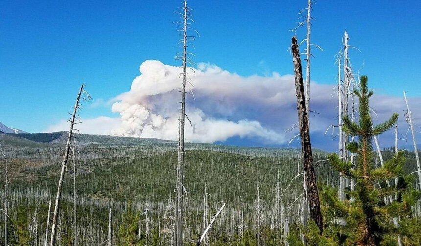
WARM SPRINGS, Ore. (KTVZ) -- Welcome rain, over an inch in places, helped firefighters battling the Lionshead Fire, the largest among several still burning across Oregon. But accompanying winds pushed flames into unburned green islands well within the perimeter, putting up smoke on Wednesday.
Here is the Oregon Department of Forestry's large-fire summary for Thursday morning:
SALEM, Ore. - The Oregon Department of Forestry is closely monitoring 9 major fires in Oregon, down from 17 originally (see table below for details). Fires are removed from the list when they are 100% lined and fire managers are confident in their progress toward containment.
There have been more than 7,500 personnel assigned to these fires, not including many of the government employees, landowners, forestland operators, and members of the community who are contributing every day. There have been resources from 39 states and multiple Canadian provinces in this fight alongside Oregonians.
About 1 million acres have burned in Oregon since the start of this year, which is nearly double the 10-year average of approximately 557,811.
| Fire name | Acres burned (est.) | Containment | Location |
| Lionshead | 203,566 | 15% | 20 miles W of Warm Springs |
| Beachie Creek | 192,838 | 49% | 15 miles N of Detroit |
| Holiday Farm | 173,094 | 35% | 3 miles W of McKenzie Bridge |
| Riverside | 138,029 | 34% | 2 miles SE of Estacada |
| Archie Creek | 131,598 | 55% | 20 miles E of Glide |
| Brattain | 50,951 | 90% | 8 miles S of Paisley |
| Slater | 43,833 in Oregon | 24% | 6 SE of Cave Junction (also in No. California) |
| S. Obenchain | 32,671 | 85% | 5 miles E of Eagle Point |
| Thielsen | 9,971 | 30% | E of Diamond Lake |
More information
- Significant Fire Potential Map
- Northwest Coordination Center – Regional Update and National Situation Report
- Inciweb (information on individual incidents)
Lionshead Fire Update
Thursday, September 24, 2020 – 10 a.m.
Rain & Wind Affect Firefighting Efforts
Special Notes: A virtual fire information public meeting was held on Wednesday. To view a recording of the meeting, go to https://www.facebook.com/LionsheadFire.
Schools have reopened. Please be aware of increased traffic.
Current Situation:
The wind picked up Wednesday afternoon, resulting in increased burning in green islands well within the fire’s perimeter. The fire gained some acreage, but containment remained at 15%. Rain fell on the fire overnight. This will reduce fire behavior and should allow crews to make even more progress. The rain was variable, but over an inch fell on some sections of the fire.
In the wake of most wildfires, there are dead trees (snags) as well as trees that are fire-weakened that tend to fall, sometimes with little warning. These trees create a hazard to firefighters as well as having the potential to block roadways needed for travel in and around the fire. Firefighters refer to these as hazard trees. When such trees are found to constitute a danger, they are cut down by crews of experienced fallers or removed with equipment.
The rainfall expected today will improve air quality. Rainfall may cause slippery roads and make travel in and around the fire difficult. Debris flows are possible, however, the amount of rain predicted is not expected to create widespread flooding.
Firefighting Efforts by Division: (Refer to the map for division breakdown.)
Very little movement has occurred on the north edge of the fire in Division A over the past few days. The contingency line north of the fire’s active edge is secure. This line should prevent spread of the fire if fire behavior picks up. Containment line is secure all the way south to Division R. Previous burnouts look secure. Progress was made in the Badger Butte area, although work continues to close a gap in constructed line. Interior islands burning out showed considerable smoke.
The east side of Division A is in patrol status with mop up operations still seeing a little heat. Crews were pulled out of some parts of Division A on Wednesday due to wind for crew safety.
In Division E, patrol and chipping operations continue.
Divisions G, I, K, and N have been quiet for several days and continue to be secure. Firefighters are monitoring and patrolling this area. Most of the road system has been prepped and is now being reinforced for indirect line.
On the southeast perimeter, working west from the Division N/R break (north of Jefferson Lake), the fireline has been secured west to the lava rock area. This area will be monitored by air operations and watched by lookouts. All line on the 12 Road is complete just short of the 20 Road. Firefighters still have work to do removing logs and slash.
Much of the fire perimeter in Division S has checked itself along the road system. There hasn’t been any significant fire movement or spread in this division for several days.
The fire in Division T has mostly checked on existing roads. Crew work is primarily patrol and cold trailing along the fire’s edge. Cold trailing is a method of controlling a partly dead fire edge by carefully inspecting and feeling with the hands to detect and extinguish any remaining heat. Firefighters are looking for and containing any spread across roadways.
The structure group continues their work in Detroit, Idanha, New Idanha, and Breitenbush securing line and mopping up.
Crews in Division W, Y and Z secured spot fires found near 46 Road. The 46 Road remains closed to the public due to the large amount of heavy equipment required for this effort. This road may remain closed until snags and other hazards are cleared and the road is deemed safe for public travel.
The north contingency group is reinforcing indirect line in Divisions A and Z along the road system. The north contingency group is working in close coordination with Riverside Fire managers to identify opportunities to connect existing roads that both fires could use in the event these indirect lines are needed. The line is being secured with heavy equipment and hand crews removing fuels. The south contingency group is working along County Road 12 to County Road 20, improving fuel breaks along the road.
Air operations completed some bucket work yesterday, but building winds made this effort difficult by afternoon.
Weather & Fuel Conditions: Today, expect rainy conditions with gusty winds over much of the fire. Southwest winds will increase to 12-18 mph with gusts of 30-35 mph. Rainfall accumulations will be higher west of the crest and lower inland.
Closures and Evacuations: Evacuation Notices remain in place for the Lionshead Fire. Level 3 “Go!” evacuation notices are still in place for the communities of Detroit, Idanha, New Idanha, and Breitenbush. A map of evacuations in Marion County is available here. There are no longer any evacuation notices for the Sidwalter/Miller flats area.
Roads and trails near the fire remain closed for public safety. The 12 Road will remain closed to the public for the near future. This includes roads and trails on the Confederated Tribes of Warm Spring lands adjacent to the fire and a 40-mile section of the Pacific Crest Trail between Santiam Pass and Olallie Lake. The Willamette National Forest, Bureau of Land Management, and State lands around the fire remain closed to the public. Go to InciWeb.gov for more information about closures in the area. Deschutes NF Alerts Willamette NF Alerts Mt. Hood NF Alerts.
Temporary Flight Restrictions: A Temporary Flight Restriction is in place over the Lionshead Fire and surrounding fires. Wildfires are a No Drone Zone. If you fly, we can’t. Whenever a drone is spotted near the fire all aircraft are grounded until we can be sure the drone is clear of the area. For more information, visit knowbeforeyoufly.org.
| Lionshead Fire Statistics: Size: 203,566 acres Containment: 15% Total Personnel: 1,370 Location: 14 miles west of Warm Springs Reported: 8/16/20, approximately 8:44 p.m. Cause: Lightning | For More Information: Information Office: 971-277-5075, 8 a.m. to 8 p.m. Media Inquiries: 541-904-0542 Email: 2020.lionshead@firenet.gov InciWeb: https://inciweb.nwcg.gov/incident/7049/ You Tube: http://www.youtube.com/channel/UCHSR6_yJRQkHyGjvvqX99gw Facebook: facebook.com/LionsheadFire |
BRATTAIN FIRE UPDATE
September 24, 2020 @ 9 AM
Please take a moment to read a joint message from Oregon/Washington BLM Director Barry Bushue and USDA Forest Service Pacific Northwest Regional Forester Glenn Casamassa in An Open Letter to Friends and Neighbors in the Pacific Northwest about Wildfires: https://www.fs.usda.gov/detail/r6/news-events/?cid=FSEPRD809403.
Yesterday:
Strong southwest winds blew throughout the day with ridgeline winds around 20-30 miles an hour. These windy conditions tested fire lines, but fire behavior remained minimal. Mop up and suppression repair/rehabilitation activities remained a top priority, as did snagging in the northwest corner. Chipper work will continue in a few days. Campgrounds in the fire perimeter received little damage, and outhouses will be unwrapped Thursday. Fire containment increased quite a bit yesterday, bringing the fire to 91% contained.
Today:
Fire behavior is expected to remain minimal. Mop up and suppression repair/rehabilitation activities remain a top priority. Haze will be visible from the northwest corner for a couple of more days where there is heavy down and dead fuel loading that continues to burn. Cooler temperatures and higher humidity will help speed up the cooling process inside the fire perimeter. The incoming local incident management team was briefed last night and takes command Friday morning after spending today shadowing the Eastern Area Incident Management Team. The Eastern Area Incident Management Team wishes to express their appreciation to Lake County, the community of Paisley and all of the cooperators who have served as hosts to the team for this incident.
Evacuations:
Area residents should sign up for Lake County Alerts, a mass notification system that provides residents with both emergency and non-emergency notifications.
Sign up at https://public.alertsense.com/SignUp/?regionid=1535.
Only one evacuation remains in place at this time. The Lake County Sheriff’s Office has issued the following evacuation notice:
Level 1 (Ready) –Highway 31 from Red House Lane (north of Paisley) north to Forest Road 29, also known as Government Harvey.
Forest Closure:
From Forest Road 29 southeast to Forest Road 3510 and the 28 Road east, all National Forest System lands and facilities are closed per Forest Closure Order 06-02-03-20-03. Forest Road 3315 is closed; the 28 Road is open.
Summary:
The Brattain fire started on September 7, 2020 and is currently burning on the Paisley Ranger District of the Fremont-Winema National Forest. The Eastern Area Type 2 Incident Management Team is currently managing the fire but will soon transition to a smaller, more localized team. Firefighting are battling winds, extremely dry conditions and shortages of firefighting resources.
SIZE: 50,751 acres
CONTAINMENT: 91%
CAUSE: Human
PERSONNEL: 440
FIRE INFORMATION:
541-947-6243
INCIWEB:
inciweb.nwcg.gov
search “Brattain Fire”
Facebook:
facebook.com, search:
Fremont-Winema National Forest @R6FWNF
South Central Oregon Fire Management Partnership @SCOFMPFIREINFO
Twitter:
Fremont-Winema National Forest @fremontwinemanf
South Central Oregon Fire Management Partnership @SCOFMPFIREINFO
LEVEL 1 EVACUATION
Highway 31 from Red House Lane (north of Paisley) north to Forest Road 29, also known as Government Harvey.
SAFETY:
Hwy 31 is open but anticipate heavy fire traffic. Avoid the area if possible.
Temporary Flight Restrictions are in effect. Avoid drone use and report drones to law enforcement.
BEACHIE CREEK FIRE UPDATE – September 24, 2020
Acres: 192,838 acres Percent Containment: 49%
Start Date: August 16, 2020 Cause: Under Investigation
Origin Location: Opal Creek Wilderness: Fuels: Timber and logging slash
two miles south of Jawbone Flats, Resources: 801
six miles north of Detroit, Oregon. Flights:Temporary Flight Restriction
No expansion of the Beachie Creek fire
Rain slows fire activity Thursday
Salem, Ore. – The Beachie Creek fire will respond favorably to the continued rainfall. Heavy cloud cover, high humidity, and showers slow fire activity and subside smoke.
Wet conditions can also cause dangers in the coming days. Drivers must recognize and be aware that there are numerous hazards present in both urban and rural driving environments. Yield to first responders. As ground moisture increases, fire-weakened trees could topple, and rock and mudslides are possible.
There was no expansion of the fire perimeter on Wednesday, though heat sources remain inside of the boundary. Fire has been smoldering underground burning tree roots and creating cavities filled with hot ash as deep as seven inches and a hot as 1,200 degrees. At these locations, crews worked Wednesday to expose the deep ash pits so today’s rain can penetrate the heat, but it will take steady rain over long periods to end the fire.
After assessing hazards, crews will adjust their level of direct engagement under trees. Most work on Thursday will occur along the Highway 22 corridor, where firefighters will monitor the fire and mitigate hazards for residents. A crew dedicated to protecting structures will also continue working in the North Santiam River and Elkhorn areas. Timber contractors are securing a control line in the 14-mile unburned area to the east of Silver Falls State Park.
The Marion and Linn County Sherriff Offices continue to evaluate and lower evacuation levels but are asking residents to stay connected with their websites and alerts:
- Marion County Sherriff’s website / evacuation maps: https://marioncounty.maps.arcgis.com/apps/webappviewer/index.html?id=5202b602f99647b9a16d488c545113b5
- Linn County Sheriff’s website here: https://linngis.maps.arcgis.com/apps/webappviewer/index.html?id=56668b1f57cf4bec9be88420a37e1183
The Willamette National Forest, Bureau of Land Management, and State lands around the fire remain closed to the public. Go to InciWeb.gov for more information about closures in the area.
| Public Contact Information: https://www.facebook.com/BeachieCreekFire2020 Email: 2020.beachiecreek@firenet.gov Phone: 541-583-0526, 8 a.m. to 8 p.m. | Inciweb https://inciweb.nwcg.gov/incident/7001/ Smoke and Air Quality http://oregonsmoke.blogspot.com/p/air-quality-now.html https://wildlandfiresmoke.net/outlooks |
ODOT UPDATE Late Thursday afternoon:
OR 126 McKenzie Highway update: Pilot car guided caravans through the road closure zone, mp 27.55 to mp 38, will begin Friday. The first will leave from the west end, two miles east of Vida, at 1 p.m. Caravans will travel one direction at a time. Saturday and Sunday schedule: 8 a.m. to 6 p.m.
Holiday Farm Fire Sept. 24 – 173,094 acres (no growth in three days) 35% contained
Springfield, Ore. – The wind blew, the rain fell, and the lines held on the Holiday Farm Fire. Sustained winds of 15-20 mph with gusts up to 40 mph hit the Willamette Valley and foothills early Wednesday afternoon stirring the embers and fanning flames deep within the interior, but nothing escaped the confines of the fire’s edge. With the Holiday Farm Fire staying put, incident managers were able to divert helicopter support to other fires that started in the nearby area.
As soon as the wind died down the rain began to fall. Overall, about an inch of rain fell on the fire overnight.
A hydrologist from the Medford office of the National Weather Service has been working alongside the incident meteorologist for the past few days. Looking at the fire area from the air and on the ground has revealed no major concerns at this time for large landslides. However, the trifecta of fire, wind and rain has taken its toll on soil conditions, further weakening tree root systems and loosening large debris. The Quartz Creek and Gates Creek watersheds on the east side of the fire sustained the most damage. The hydrologist said that small slides are expected to impact forest roads throughout the winter.
Hazards along Highway 126 still exist. Road crews from ODOT and fire personnel continue to make progress cutting hazard trees and removing large debris from the road surface with heavy equipment. The McKenzie Highway remains closed from milepost 28 east to milepost 38. For more information regarding road closures and delays, visit https://www.oregon.gov/odot/Pages/Wildfire.aspx or www.tripcheck.com.
Despite the rain and cooler conditions, fire season remains in effect. Outdoor debris burning remains prohibited and several other spark emitting activities are restricted. To assure a safe and clean burn of your piles this fall, cover a portion of the piles with plastic to keep it dry for easy ignition later. To learn about fire restrictions in your area, please visit https://www.oregon.gov/odf/fire/pages/restrictions.aspx.
