Bend swelters through hottest July on record; Prineville’s was second-hottest
NWS August outlook: Hotter than normal, dry as usual
BEND, Ore. (KTVZ) -- Bend-area residents sweated through the hottest July on record, and it was close -- second-hottest -- in Prineville, the National Weather Service said Monday.
According to preliminary data received by the NWS in Pendleton, temperatures at Bend Airport, the official monitoring station, averaged much warmer than normal during the month of July.
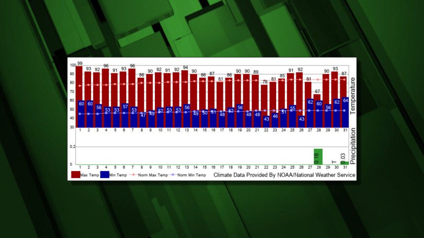
The average temperature was 70.9 degrees, which was 6.4 degrees above normal. High temperatures averaged 88.7 degrees, which was 7.2 degrees above normal. The highest was 99 degrees on the 1st. Low temperatures averaged 53.1 degrees, which was 5.6 degrees above normal. The lowest was 43 degrees, on the 22nd.
The temperature exceeded 90 degrees on 14 days.
This was the warmest July on record, NWS said. The previous warmest average temperature was 70.3 degrees, in 2014
Bend's precipitation totaled 0.21 inches during July, which was 0.35 inches below normal. Measurable precipitation -at least .01 inch - was received on two days, with the heaviest, 0.18 inches, reported on the 28th.
Bend's precipitation this year has reached 4.02 inches, which is 2.26 inches below normal. Since October, the water year precipitation at Bend has been 8.12 inches, which is 2.35 inches below normal.
The outlook for August from NOAA's Climate Prediction Center calls for above-normal temperatures and near-normal precipitation. Normal highs for Bend during August are 81.3 degrees and normal lows are 46.4 degrees. The 30-year normal precipitation is 0.48 inches.
Temperatures at Prineville Airport also averaged much warmer than normal during the month of July.
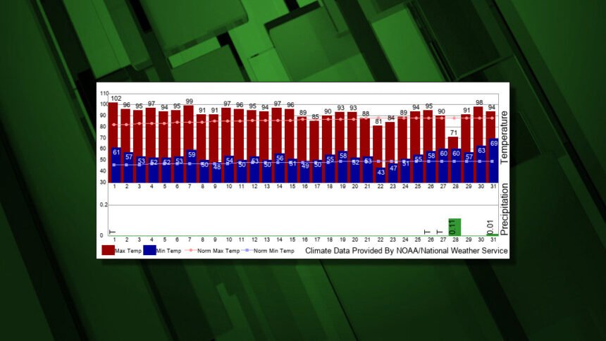
The average temperature was 73.2 degrees, which was 6.3 degrees above normal. High Temperatures averaged 92.3 degrees, which was 6.4 degrees above normal. The highest was 102 degrees on the 1st. Low temperatures averaged 54.2 degrees, which was 6.3 degrees above normal. The lowest was 43 degrees, on the 22nd.
On 22 days, the temperature exceeded 90 degrees.
This was Prineville's second-warmest July on record. The warmest was 73.4 degrees, set back in 1922.
Prineville's precipitation totaled 0.12 inches during July, which was 0.44 inches below normal. Measurable precipitation -at least .01 inch - was received on two days, with the heaviest, 0.11 inches, reported on the 28th.
Precipitation this year has reached 3.81 inches, which is 2.70 inches below normal. Since October, the water year precipitation at Prineville has been 6.35 inches, which is 3.61 inches below normal.
The Prineville outlook for August from NOAA's Climate Prediction Center calls for above-normal temperatures and near-normal precipitation. Normal highs for Prineville during August are 85.4 degrees and normal lows are 46.6 degrees. The 30-year normal precipitation is 0.34 inches.
