Snow falls in Seattle, Portland during rare cold snap; OSP reports numerous crashes around state
(Update; Numerous crashes reported around state)
Sub-zero wind chills threaten in coming days
SEATTLE (AP) — Snow blanketed much of Central Oregon and many other parts of the Pacific Northwest on Sunday as unusually cold temperatures in the region began to settle in, also threatening sub-zero wind chills in coming days.
Between 3 and 5 inches of snow fell in Seattle overnight. Observers in Port Angeles, across the Puget Sound on the Olympic Peninsula, reported about 11 inches (28 centimeters) of snow.
Another 2 to 5 inches of snow were expected to fall in parts of northwest and west central Washington during the day, the National Weather Service said.
Portland received a dusting of snow from the storm, but the city was expected to get another 2.5 inches during the day, according to the weather service.
“It’s cold enough for snow and there’s enough moisture around, so we have enough snow to see snowfall across the area,” NWS Seattle meteorologist Jacob DeFlitch told The Seattle Times.
Frigid temperatures in the region could tie or break records in the coming days.
The Seattle area is expected to dip as low as 18 degrees F (-7.7 C), the lowest in several years. Coeur d’Alene, Idaho, will drop to -5 F (-20 C) by Wednesday.
In Portland in the early part of the week, overnight temperatures will be bitter cold, getting down to the low 20s and high teens.
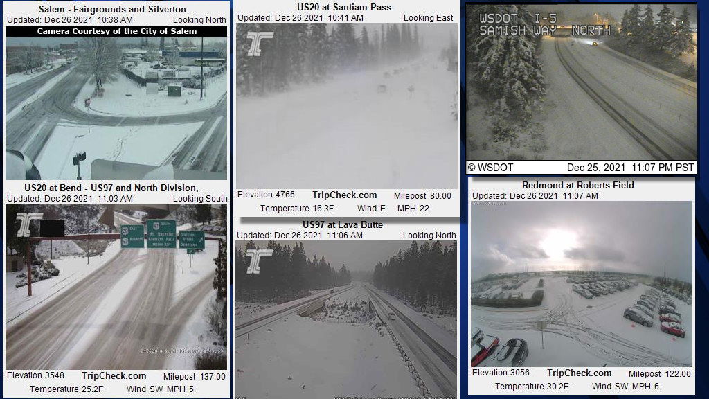
The NWS issued a winter weather advisory for Central Oregon through 4 a.m. Monday, with 2-4 inches of snow expected from Bend south and 1-2 inches elsewhere, amid winds gusting to 35 mph on Sunday afternoon.
Weather spotters reported four inches of snow overnight in the La Pine area, 3 1/2 inches near Sisters and nine inches near Camp Sherman. Other weather spotters recorded an inch in Prineville and lesser amounts in locations around Bend and Redmond.
Motorists were warned to plan on slippery road conditions and difficult travel, and advised to slow down and use caution while traveling. KTVZ.COM's webcams page also includes a link to ODOT TripCheck.
Numerous crashes were reported around the region and state on Sunday. Oregon State Police said Sunday afternoon in a social media post. "Snow and ice are wreaking havoc on highway traffic," with ODOT and law enforcement "responding to crashes and disabled vehicles everywhere."
Troopers encouraged motorists to "avoid unnecessary travel" -- and if one must, to use TripCheck or call 511 for road conditions before heading out.
They also urged motorists to have food, warm clothes and an emergency kit in their car, not to depend on GPS that may send you to closed or unmaintained roads, and to "tell someone where you're going and when you expect to return."
Mt. Bachelor reported a foot of new snow overnight and two feet in 24 hours, for a base depth of 65 inches. The resort also warned drivers that roads and parking lots "are filling with snow faster than the plows can keep up," bringing "blizzard-like conditions, with temps in the single digits, ripping winds and heavy snow."
They also issued a tree well safety alert and advised skiers and boarders to "always ski and ride with a buddy when venturing off trails."
Hoodoo Ski Area reported seven inches of new snow in 24 hours and a base of 66 inches, with temperatures in the teens and winds at close to 30 mph.
Chains or traction tires were required to get to the resorts; find more info on our Snow Report page.
The NWS also warned of "dangerously cold temperatures" in coming days across Central and Eastern Oregon as an arctic air mass moves in, dropping lows to single digits and teens Monday through Thursday and wind chills as low as 10 below zero.
With these very cold temperatures, frostbite and hypothermia will occur much faster, forecasters said. If outdoors, remember to dress in layers and cover exposed skin. Uncovered pipes will be susceptible to freezing and bursting.
A slow moderating trend may begin on Thursday, with the potential for wintry weather that will continue into Friday.

