Flood watches issued for areas of Central, Eastern Oregon as Tropical Storm Hilary’s remnants bring threat of landslides
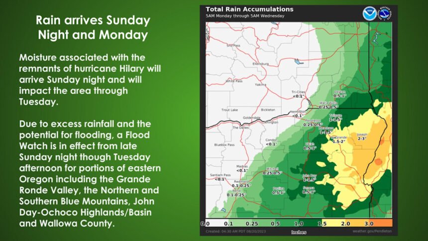
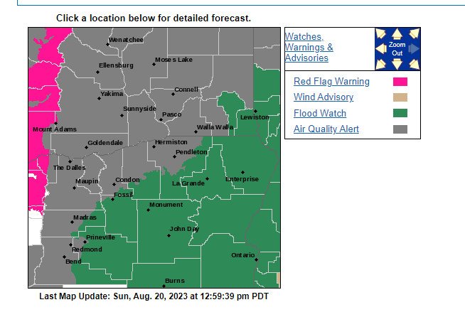
PORTLAND, Ore. (KTVZ) -- The National Weather Service has issued flood watches for portions of Central and Eastern Oregon as the remnants of now-Tropical Storm Hilary surge northward toward the state.
The areas include the Grande Ronde Valley, Northern Blue Mountains of Oregon, Southern Blue Mountains of Oregon, Wallowa County, Baker County, Harney County, Malheur County, Oregon Lower Treasure Valley, John Day Basin, and Ochoco-John Day Highlands. The watches are in effect from late Sunday evening through Tuesday afternoon.
Heavy rain from the remnants of Hurricane Hilary may result in landslides in areas of steep terrain, as well as debris flows in and near burn scars from recent wildfires, the Oregon Department of Geology and Mineral Industries said Sunday afternoon.
Find the latest NWS information here: https://alerts.weather.gov/cap/or.php?x=1
Debris flows are rapidly moving, extremely destructive landslides. They can contain boulders and logs transported in a fast-moving soil and water slurry down steep hillsides and through narrow canyons. They can easily travel a mile or more. A debris flow moves faster than a person can run. People, structures, and roads located below steep slopes in canyons and near the mouths of canyons may be at serious risk.
If your home, work, or route is in a watch area:
- Stay alert. Track the flood watch by radio, TV, weather radio or online. If told to evacuate, do so immediately.
- Listen. Unusual sounds might indicate moving debris, such as trees cracking or boulders knocking together. A trickle of falling mud or debris may precede larger landslides. If you think there is danger of a landslide, leave immediately.
- Watch the water. If water in a stream or creek suddenly turns muddy or the amount of water flowing suddenly decreases or increases, this is a warning that the flow has been affected upstream. You should immediately leave the area because a debris flow may soon be coming downstream.
- Travel with extreme caution. Assume roads are not safe. Be alert when driving, especially at night. Embankments along roadsides may fail, sending rock and debris onto the road.
For more landslide and debris flow information: https://www.oregon.gov/dogami/landslide/Pages/debrisflow.aspx
