Crazy Creek Fire lines hold in 50 mph wind gusts; nearly 87,000-acre blaze now 93% contained
PAULINA, Ore. (KTVZ) -- Winds gusted up to 50 mph Saturday on the nearly month-old Crazy Creek Fire, but containment lines held and crews reached 93% containment, allowing Crook County emergency managers to reduce some evacuation levels, officials said Sunday.
Here's the full update on that and the more than month-old, 730-acre Red Fire burning 5 miles west of Crescent Lake Junction, still at zero containment.
Crazy Creek Stands the Test of Time: Lines Hold After 50 mph Wind Gusts
Daily Update August 18, 2024
Fire Information Phone: 541-208-1768 (8 a.m.-8 p.m.)
Email: 2024.crazycreek@firenet.gov
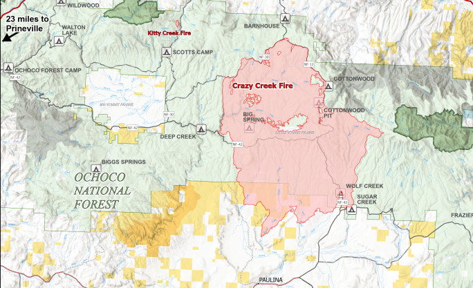
Acres: Crazy Creek – 86,928; 93% contained
Kitty Creek – 73; 100% contained
Location: Crazy Creek: 5 miles north of Paulina, Oregon; 498/Kitty Creek: 7 miles south of Mitchell, Oregon
Start Date: July 22, 2024 Personnel: 564
Resources: 17 crews | 0 helicopters | 21 engines | 6 bulldozers | 18 water tenders | 1 masticator |
6 skid steers
Highlights: Wind gusts up to 50 miles an hour were recorded Aug. 17 over the Crazy Creek Fire, but containment lines held. The fire remains at 86,928 acres, with containment increasing to 93 percent.
The stronger wind speeds rekindled larger heat sources within the interior of the fire, such as burned tree stumps and logs, but there were no reports of spreading flames.
Firefighters will remain on patrol to maintain current containment lines and extinguish interior hot spots as lower humidity levels are making smaller-diameter vegetation and debris more susceptible to ignitions. Crews are also rehabilitating fire lines around both the Kitty Creek and Crazy Creek Fires to return them to a more natural state.
Evacuations: The Crook County Sheriff’s Office has lowered the evacuation level from Level 3 (recommended evacuation) to Level 2 (set for evacuation) from Highway 380 north to SE Puett Road. The area north of SE Puett Road around the perimeter of the fire remains at a Level 3. The area south of Highway 380 has been lowered to Level 1 (prepare for possible evacuation). An evacuation map is available online through the Crook County Emergency Management Office website.
Weather: We can expect hot, dry, and windy conditions into next early next week. Temperatures will remain close to the same as well as humidity down into the teens. Winds are expected to remain around the 10 to 15 miles per hour range, but become less frequent.
Importance of Fire Prevention: All public lands in Central Oregon, including the Ochoco National Forest, are in Stage 2 Public Use (Fire) Restrictions. All open flames, including woodstoves and charcoal briquette fires, are prohibited. In times of high fire danger, it is crucial for everyone to follow prevention measures to avoid additional strain on overburdened resources.
Fire Restrictions and Closures: The Ochoco National Forest has implemented a forest closure for the eastern portion of the Paulina Ranger District. The Bureau of Land Management has issued a temporary closure for portions of public lands in Crook and Grant Counties.
More Information:
InciWeb: https://inciweb.wildfire.gov/incident-information/orocf-crazy-creek
Facebook: Facebook.com/Crazy Creek Fire
Central Oregon Wildfire Information: https://centraloregonfire.org/
--
RED FIRE DAILY UPDATE
Sunday, August 18, 2024
541-208-1766, 2024.red@firenet.gov
https://inciweb.wildfire.gov/incident-information/ordef-red-fire https://www.facebook.com/2024RedFireOR/
Size: 730 acres Location: 5 miles west of Crescent Lake Junction, OR County: Klamath
Start Date: July 17, 2024 Cause: Lightning Containment: 0% Total Personnel: 244
Crescent, OR – The Red Fire is burning within the Diamond Peak Wilderness of the Deschutes National Forest, on the southwest slope of Redtop Mountain. The fire is being managed under a full suppression strategy. Public and firefighter safety is the highest priority in managing this fire.
Shaded Fuel Break Phases – Firefighters are completing the shaded fuel break in three phases Phase 1 includes cutting and stacking selected trees using logging equipment; Phase 2 includes limbing, trimming, and removing cut trees off site; and Phase 3 includes masticating brush and tree limbs to remove and reduce vegetation that could be fuel for the fire.
Yesterday’s Activities – Phase 3 of the shaded fuel break is 100% complete spanning from the railroad near Odell Lake to the Crescent Lake Snowpark. Phase 1 is nearly complete, and progress continued along the Crescent Lake Summer Homes. Team members from Northern Rockies Incident Management Team 8 arrived and received an overview of the fire in preparation for the transition of command.
Today’s Activities – The Southern Area Gray Team is happy to welcome the Northern Rockies Incident Management Team 8 to Oregon. Today, they will shadow the Southern Area Gray Team members as they coordinate their transition into leadership roles and prepare to assume command of the fire on Monday, August 19, at 6 a.m. Crews will continue implementation of Phases 1 and 2 around the fire area in coordination with heavy equipment.
Weather and Smoke – Winds are expected to be around 7-10 mph out of the west with temperatures in the mid-60s in the fire area. The fire will continue to creep and smolder. Air quality information can be found at https://fire.airnow.gov/.
Closures – The Deschutes National Forest has implemented an emergency closure around Crescent Lake and in the Diamond Peak Wilderness. The public should note that Forest Service Road 60 is closed, and road guards have been posted for public safety. More closure information is available at: https://www.fsa.gov/alerts/deschutes/alerts-notices/?aid=89091
Evacuations – The WILDFIRE! Level 1 – BE READY to Evacuate notice issued by Klamath County Emergency Management for the Crescent Lake, Odell Lake, and Crescent Junction areas remains in effect
(INCENDIO FORESTAL! Nivel 1 - ESTÉ PREPARADO para evacuar de las siguientes zonas: Crescent Lake, Odell Lake, Crescent Junction). Visit www.klamathcounty.org/300/emergency-management for more information or to sign up for alerts.
Fire Restrictions – Stage 2 Public Use Fire Restrictions – which prohibit open fires, including in developed campgrounds – are in effect for the Deschutes National Forest. The Industrial Fire Precaution Level is currently Level IV “General Shutdown.” Visit fs.usda.gov/detail/deschutes/home/?cid=stelprdb5297376 for more information.
Drone Restrictions – Aerial firefighting is suspended when unauthorized drones (UAS) are in the area. Unauthorized drone use over a fire area poses serious risks to fire personnel and the effectiveness of wildfire suppression operations. If you fly, we can’t.
