Darlene 3 Fire 50% contained as crews make more progress; some evacuees and firefighters heading home; no homes lost
(Update: Saturday morning update; cost to fight $3.1 million)
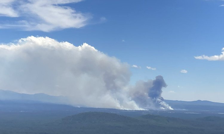
La PINE, Ore. (KTVZ) -- Firefighters on the 4-day-old Darlene 3 Fire southeast of La Pine have the blaze fully lined and 50% contained, officials said Saturday. The progress made so far has some residents able to return home, as well as firefighters called in from across the state to help battle the blaze and protect homes and other structures.
In its daily report Saturday, the National Interagency Fire Center put the cost so far of fighting the Darlene 3 Fire at $3.1 million. But in context, for the Northwest region, that's just third in terms of cost on the list of eight active fires. The 4,711-acre Pioneer Fire in southeast Washington has a firefighting cost so far of $14.1 million, while the nearly 1,000-acre Upper Applegate Fire south of Ruch in southwest Oregon has cost $6.1 million to fight.
Here's Saturday morning's full update from Darlene 3 Ffire officials:
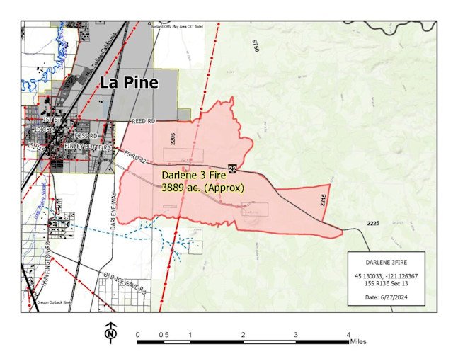
Darlene 3 Fire | June 29, 2024
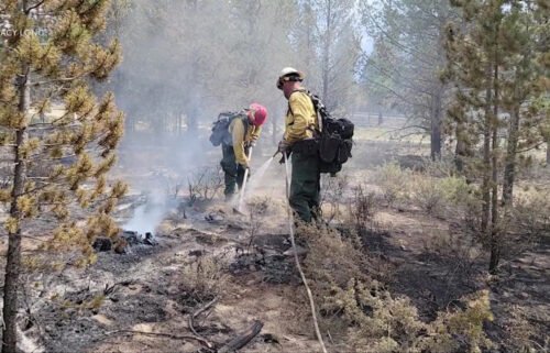
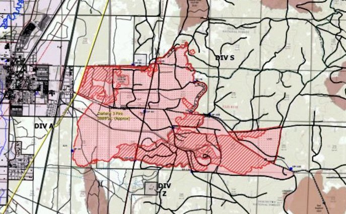
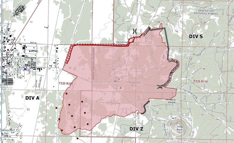
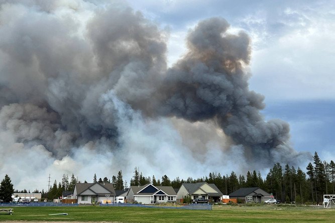
Central Oregon —Fire crews were able to increase containment to 50% on the 3,889-acre Darlene 3 Fire. All containment lines held overnight. Increasing containment and keeping the fire within its current footprint remains the primary focus. Remaining fire crews will continue to watch for spotting and provide structure protection if necessary.
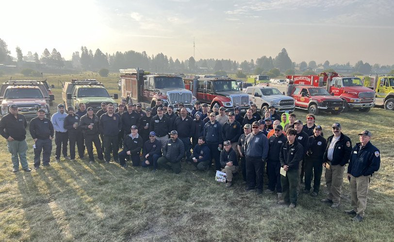
Saturday will be the last day for the Oregon State Fire Marshal’s Red Team on the incident and Central Oregon’s Type 3 Incident Management Team will assume full command.
“It’s been an honor to be in unified command with our partners at Central Oregon Fire Management Service,” said OSFM Red Team Incident Commander Ian Yocum. “We are here to protect the people of Oregon to keep fires small and away from communities, and we can support that mission because of the Oregon fire service, and their willingness to answer the call. We’re leaving the Darlene 3 Fire in the excellent hands of our wildland partners, and they will continue to provide for the safety of La Pine.”
The weather continues to be favorable for fire suppression, with low winds during the day and high humidity at night. Some smoke will continue to remain in the area due to the stable atmosphere, especially in low-lying areas. Friday night saw the last night shift, and firefighters will continue to conduct day operations focused on full containment, supported by infrared drones checking for hot spots.
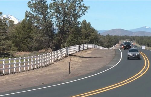
At noon on Friday, June 28, the Deschutes County Sheriff’s Office was able to reduce the evacuation level for Newberry Estates from Level 3 (Go Now) to a Level 2 (Be Set). Additionally, all evacuation notices have been lifted for the area west of Hwy 97 and north of Burgess Road. For the most up-to-date official evacuation information please visit Deschutes County evacuation information: www.deschutes.org/emergency. The La Pine Activity Center remains open for RVs to park and has meals for evacuees and N95 masks for those impacted by smoke. N95 and KN95 masks are also available free to the public at both La Pine Rural Fire Department fire stations and the department’s administrative building. Air quality information can be found at aqi.oregon.gov or by downloading the OregonAir app.
As residents return to their homes, fire managers would like to remind everyone that this is just the beginning of fire season. Residents can help improve the safety and efficiency of firefighters by maintaining defensible space around their homes. Well-maintained defensible space entails removing all flammable material around the home for a 5-foot radius and trimming vegetation away from siding and eaves, as well as removing fallen leaves and needles from roofs and decks. Working outward, residents can keep the surrounding vegetation lean and green, reduce ladder fuels and limb up trees to help prevent fire from reaching the crowns.
There are fire-weakened trees within the fire footprint. Firefighters will be conducting falling operations to mitigate hazard trees, so it is critical that visitors avoid closed areas. Prairie Campground and the Rosland OHV area and associated trails remain closed. McKay Crossing Campground, Ogden Group Campground and 6 Mile Sno Park will reopen at noon on Sunday, June 30. An Area Emergency Closure is also in effect on the Deschutes National Forest, the notice and closure map are available here: https://www.fs.usda.gov/Internet/FSE_DOCUMENTS/fseprd1183408.pdf. Paulina Lake Road and NFSR 22 east of the closure boundary are still open for public use. The Prineville District Bureau of Land Management’s Emergency Public Land Closure also remains in effect. This notice is available online at https://www.blm.gov/programs/public-safety-and-fire/fire-and-aviation/regional-info/oregon-washington/fire-restrictions.
For current wildfire updates, the public can visit centraloregonfire.org or follow fire information on X (Twitter) @CentralORFire or call the Central Oregon Fire Info phone line: 541.316.7711.
Here's Saturday morning's operational update:
--
Amid the outpouring of thanks on signs and in many other ways around La Pine for firefighters' efforts, Deschutes County commissioners issued a statement Friday:
"The Deschutes County Board of Commissioners would like to thank our first responders and interagency partners who are working around the clock to respond to the Darlene 3 Fire and protect our community. We are so fortunate to live in Central Oregon, with a world class response system in our backyard.
"We also want to thank our residents, who have come together to support each other during this difficult time. Our thoughts are with all of you who are impacted by the fire and evacuation notices. A special thanks to neighbors in Bend, Redmond, Sisters, and across Central Oregon for your care and support for the La Pine community.
"In Central Oregon, we live in a fire-adapted ecosystem. We work year-round to protect and prepare our region for the impacts of fire through the efforts of Project Wildfire and other collaborative efforts.
"Thank you to everyone involved in this community response. Our thoughts are with each of you."
--
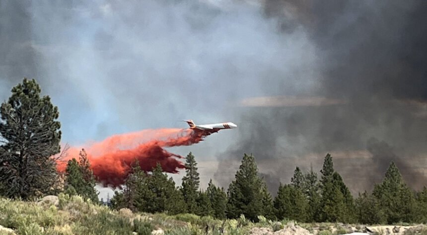
In Friday's update, officials said, "Cooler temperatures and calmer winds during the day on Thursday allowed crews to increase containment lines with the help of dozers and retardant drops."
"Some spotting occurred yesterday (Thursday) to the east, but crews continue to aggressively seek and suppress any spot fires beyond the current containment lines.
"Crews have established patrols around the entire perimeter of the fire and will take advantage of the cooler, calmer weather over the next two days to harden containment lines and reduce the risk of flare ups within the burn footprint.
"Teams have been successful in protecting key community assets, including the La Pine Community Cemetery off Reed Road, power lines, a cell tower and the city’s water supply. Due to decreased fire threat to the community, fire managers were able to release some of the OSFM structural protection task forces to their home agencies."
The fire's incident management teams held a "virtual community meeting" for an update late Friday afternoon, streaming live and by an available recording at https://www.facebook.com/DeschutesCountySheriff.
Incident Commander Ian Yocum told those watching he was pleased to report that "we did not lose one home or resident on this fire." He said so much progress had been made, with control lines around the entire fire perimeter, the regional task forces called in by the Oregon State Fire Marshal get to go home Saturday.
About 1,500 homes had been in the Level 3 or 2 evacuation area at the peak, along with critical infrastructure, including cell and communications towers that crews protected, as well as a community cemetery.
Here's the noon Friday update from Deschutes County Sheriff's Office emergency managers:
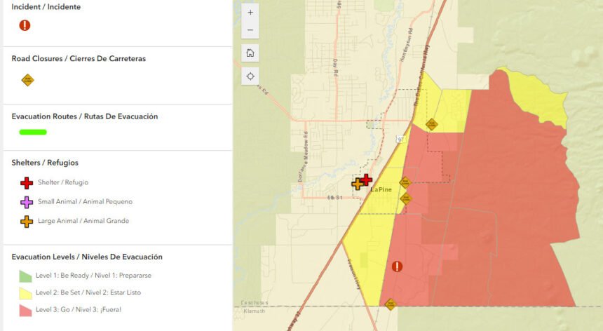
After consultation with fire managers, the Deschutes County Sheriff's Office is lowering some evacuation levels. These levels may change again as conditions change. Residents should remain vigilant and stay informed about changing conditions.
The Newberry Estates subdivision has been reduced from Level 3: Go Now to Level 2: Be Set. Residents should understand there is still risk and they should be prepared to evacuate at a moment's notice.
The residential area immediately north of Burgess Road and east of the Little Deschutes River has been reduced from Level 1: Be Ready to no evacuation notice.
All other areas under various evacuation notices have remained unchanged.
Updated maps and information can be found at www.deschutes.org/emergency.
--
Earlier info:
Wednesday's wind-driven new growth to the east increased the fire's size to 3,889 acres, officials said Thursday. Emergency managers also adjusted the evacuation zones, reducing some from Level 3 to Level 2.
Asked Thursday about the fire investigation, the Central Oregon Fire Management Service told NewsChannel 21, "The cause of the fire remains under investigation. We do know it was human-caused (there has been no recent lightning). Federal, state and county law enforcement agencies are actively involved in that investigation and information will be released as it is available."
Thursday evening, amid concerns raised by area residents, fire officials said "the La Pine Community Cemetery has not been impacted" by the fire. "Crews worked hard during initial attack on Tuesday to build the line off Reed Rd to protect it and other assets to the north."
--
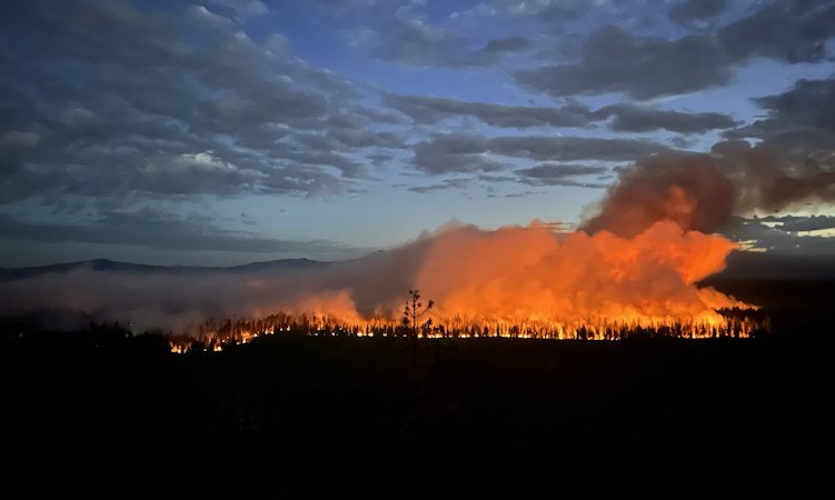
Wednesday night, crews "successfully lined and completed firing operations on the new growth to the east," officials said in Thursday's earlier update.
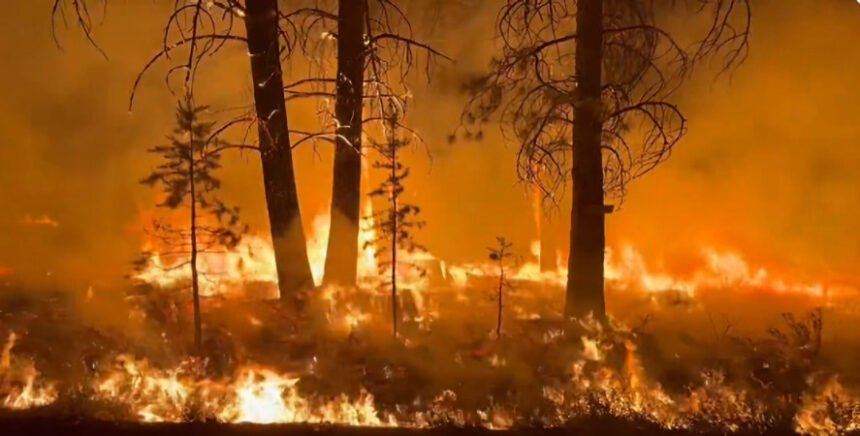
The that broke out Tuesday afternoon southeast of La Pine has prompted a major air and ground attack, hundreds of evacuations and a Conflagration Act call-up of six task forces from around the region and state.
"The predicted westerly winds have pushed the fire east toward Finley Butte," a Wednesday evening update said. "Air and ground resources are engaged and heavy equipment continue to arrive to aid in the efforts."
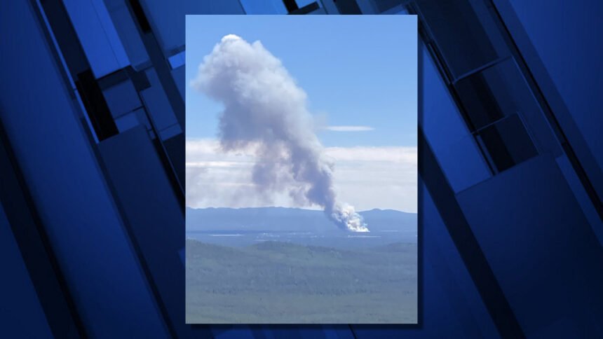
The cause of the blaze that put up tall, surging plumes of smoke for hours Tuesday “is actively being investigated,” officials said.
Firefighters worked through the night for a second night to establish control lines around the fire perimeter.
Winds and warm temperatures tested those lines and pushed the blaze east, prompting burnout operations along two roads to stop its advance, as fire officials explain in Thursday's video update:.
"Fire investigators are actively investigating this fire," officials said. "As we move into the dry summer months here in Central Oregon, it is imperative for our community and visitors to be vigilant about fire safety. Please be aware of and check with local land management agencies for current fire restrictions as we move into a high fire danger level across Central Oregon."
The Central Oregon Type 3 team with Incident Commander Vince Grace took command of the Darlene 3 Fire Wednesday morning, in unified command with Oregon State Fire Marshal Red Team, Incident Commander Ian Yocum.
Structure and wildland resources continue to arrive at the Incident Command Post in La Pine to support the fire. Six task forces of structural firefighters will be actively working to prep and protect structures. These include the eastside of the City of La Pine, Newberry Estates, as well as nearby water and power infrastructure.
Darlene 3 Fire Public Information Officer Stacey Long said Wednesday, "Task force OSFM have been out with our communities and in the areas where the homes are, making sure that they're protected as needed."
On Wednesday morning, the Deschutes County Sheriff's Office issued a Level 1 BE READY evacuation notice for the area west of Highway 97 north of Burgess Road, east of the Little Deschutes River and south of Riverview Drive.
Also, Forest Service land on the eastern side of the fire that was previously at LEVEL 2 BE SET was upgraded to LEVEL 3 GO NOW. The area on the north side of Paulina Lake Highway remained at LEVEL 2 BE SET.
"We'll continue to order resources as needed," Long told NewsChannel 21. "We have our great team out there right now, our operations folks are out there seeing if they have what we need to keep it in its footprint today."
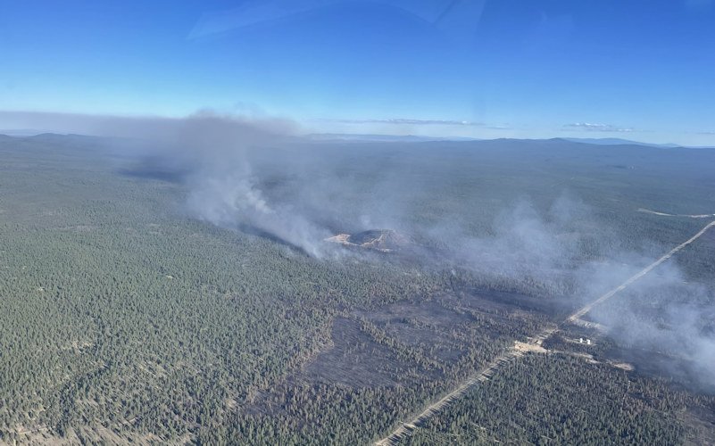
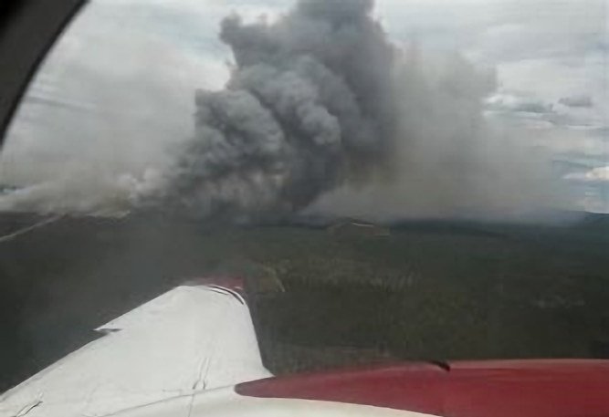
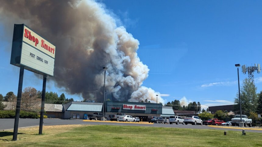
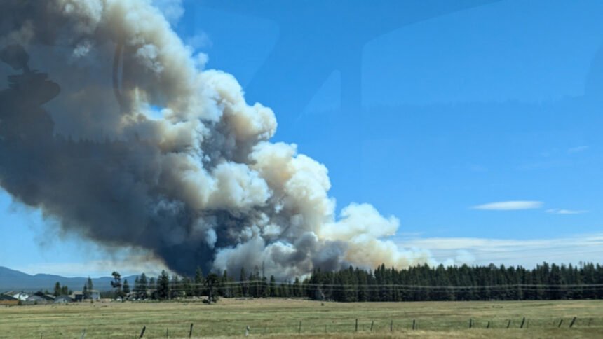
The fire was reported around 1 p.m. Tuesday near Darlene Way on the southeast outskirts of La Pine and quickly put up huge, billowing smoke plumes as it raced across 1,700 acres by nightfall, prompting a rapidly changing mix of, Level 3 GO NOW evacuations and Level 2 BE SET alerts, public land closures and a power shutoff in the area.
NewsChannel 21 obtained what a neighbor said is footage of a homeless camp on fire in the area Tuesday around the time the fire was reported.
Central Oregon fire dispatch first reported around 1:15 p.m. that Incident 289 was burning a mile southeast of La Pine, on the east side of Darlene Way near Finley Butte Road. The fire was initially estimated at 3-5 acres and officials said four engines, a bulldozer, a crew and several air resources were responding. The cause was under investigation.
By 2:15 p.m., the fire was estimated at 15 acres and spreading to the northeast, with more air and ground resources ordered in. Before 3 p.m. came word the newly named Darlene 3 Fire had grown to about 50 acres as the air and ground battle was fully underway
Three local task forces made up of firefighters from numerous agencies rushed to help tackle the blaze as new spot fires were reported and an unconfirmed scanner report the blaze had jumped to the north side Finley Butte Road around 2:10 p.m. The later focus was on stopping the fire as it moved toward Reed Road.
Shortly before 2 p.m. Tuesday, Deschutes Alert sent out a wildfire evacuation notice – ‘Level 3 – GO NOW!’ The area covered by the evacuation notice is east of the railroad tracks, near Darlene Way and Ice Cave Road. Around 2:30 p.m. emergency managers added a Level 2 "GET SET" evacuation notice for areas east of Highway 97 and south of Rosland Pit.
The sheriff's office urged that people continue to visit deschutes.org/emergency for the most up-to-date evacuation levels.
The DCSO said Tuesday night the American Red Cross is staffing the evacuation shelter at La Pine High School (51633 Coach Rd.) with additional support from the Deschutes County Medical Reserve Corps.
The La Pine Activity Center (16450 Victory Way) is open for RVs to park and has space for animals.
The La Pine Rodeo Grounds is accepting livestock and companion animals in coordination with the Pet Evacuation Team.
Bend Pet Resort (60909 SE 27th St., Bend), is accepting cats and dogs and can be reached by calling 458-666-7505.
Jodi Kerr was packing up her home decor and gifts store in La Pine so she could evacuate, The Associated Press reported.
“It’s part of the risk of living in an area like this. It’s beautiful, but it’s wild,” said Kerr, the owner of Meandering Maker Mercantile.
She said it’s hard to think about the people who’ve spent years building businesses and then be concerned about losing it all overnight.
The Forest Service said McKay Crossing Campground, Prairie Campground, Ogden Group Camp and the Rosland OHV play area and associated trails on the Deschutes National Forest were evacuated and closed. Six Mile Sno-Park also was closed Wednesday due to the fire.
Midstate Electric Cooperative told Newberry Estates residents around 3:20 p.m. Tuesday it was "highly probable" they would have to enact a Public Safety Power Shutoff in the area. Twenty minutes earlier, they posted that the fire was moving in the direction of the area's Bonneville Power Administration substation.
At 5:30 p.m., the cooperative said power was out "in various areas of our service territory" - their outage map for a time showed just over 2,000 members without power.
Midstate Communications Manager Sina Streeter said Wednesday morning there were still "a few services in the Finley Butte area" that were out.
"We are waiting for access to the burn area to complete assessments of affected equipment," she said, adding that "all critical infrastructure is operational at this time."
Midstate had this message for members Wednesday evening on their Facebook page:
"Due to the ongoing Darlene Fire activity and adverse weather conditions, we have placed our distribution system on our most sensitive settings. If a power outage occurs while the system is in wildfire mitigation settings, all of the affected lines are required to be inspected before power can be restored, resulting in longer restoration times. The safety of the public and our membership is a top priority. With evacuation notices in place, please take the necessary precautions to keep you and your family safe. We’ll keep you updated as the situation evolves."
The Prineville District Bureau of Land Management also issued an Emergency Public Land Closure on Tuesday. The closure included all BLM-administered lands within an area bounded by Forest Service Road 180 on the south, Highway 97 on the west, Paulina Lake Road on the north, and the Deschutes National Forest Boundary on the east.
"This closure is effective immediately and will remain in effect until such a time as conditions allow for safe use of the public lands."
The fire's name - Darlene 3 - points to a history of wildfires in the area. In mid-July of 2021, the Darlene Fire burned nearly 700 acres before it was contained and destroyed two homes.