‘Mega-fires’ hit Oregon hard: We take an in-depth look at the nearly 137,000-acre Lone Rock Fire, now 40% contained
Isabella Warren has a report on NewsChannel 21 at Five
LONEROCK, Ore. (KTVZ)-- One of Oregon's largest wildfires of recent weeks, the nearly 2-week-old Lone Rock Fire, recently reached "mega-fire" status, meaning it's burned more than 100,000 acres of land.
Isabella Warren is speaking Thursday with on-the-ground officials and the Oregon Department of Forestry to learn what this weekend might look like for the more than 1,000 firefighters on the Lone Rock Fire and other mega-fires burning across the region. Her report is coming up tonight on NewsChannel 21 at Five.
Below is Thursday's update on the fire:
Lone Rock Fire Update | July 25, 2024
- 10:40 am
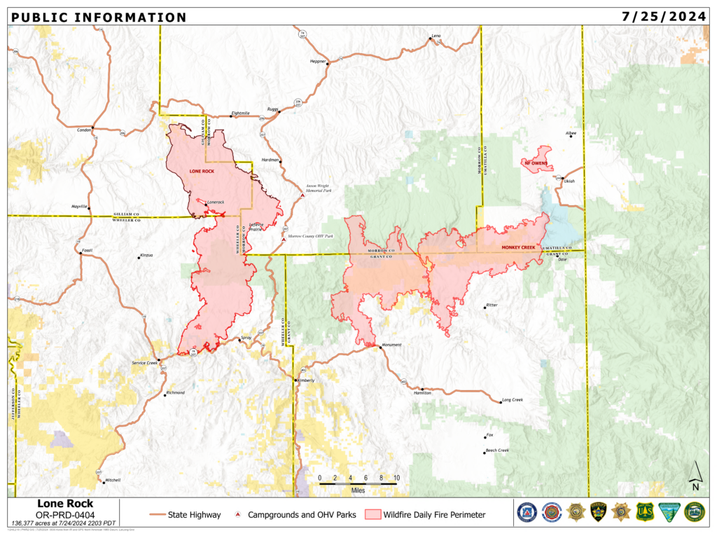
Location: Lonerock, Oregon to west of Highway 207| Size: 136,377 acres | Containment: 40% | Cause: Under Investigation | Start Date: July 13, 2024 | Total Personnel: 1,011
InciWeb: https://inciweb.wildfire.gov/incident-information/orprd-lone-rock-fire
Fire Information Line: 541-208-4369 | Email: 2024.0404rvlonerock@firenet.gov
Condon, Ore. — The Lone Rock Fire is being managed under a full suppression strategy by the unified command of the Northwest (NW) Team 2 and Oregon State Fire Marshal (OSFM) Red Team.
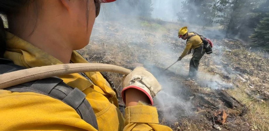
Yesterday’s Activities: Firefighters efforts to contain the spread of the Lone Rock Fire continue to improve. The entire fire perimeter has some form of fireline around it. However, a few areas continue to hold heat. The small increase in acres burned is a result of fire burning interior to existing control features. The forecast severe weather passed further to the southeast and any gusty, outflow winds from the weather system did not compromise existing containment features.
Patrol and mop-up activities continued throughout Wednesday and overnight. There were a few areas where fire did cross existing lines, but firefighters were able to contain those spot fires. Crews were successful in completing firing operations and fireline construction work along Highway 19. A large crew presence remains and will continue to patrol and monitor this critical area. Containment features along Alder Creek held well, and no spot fires were reported in the area. Crews continue to patrol the area.
The remaining unburned fuel area within the fire perimeter north of Forest Service Road (FSR) 25 continued to fill in and burn, though minimal fire behavior occurred within the fire perimeter overall. Firing operations were successful around Lone Creek Road. Crews will continue to monitor and mop up the area.
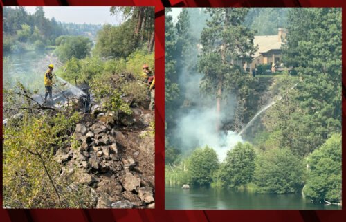
Oregon Office of the State Fire Marshal (OSFM) task forces worked to mop up at least 100 feet away from homes that were protected during the fire’s most intense growth. An OSFM task force working out of Spray, Ore. also responded to a report from a homeowner that fire was moving close to their house. They were able to stop the growing fire and protect the home.
Today’s Activities: Crews will continue to patrol, monitor, and mop-up along north end of the fire. Firefighters will look for opportunities for strategic burning operations along the east side of the fire near Flatiron Spring and carry on work from night operations.
On the west side of the fire, crews will focus on continuing to mop-up the fire perimeter as well as any of the spot fires that occurred yesterday. Firefighters are also looking into carrying out strategic firing operations in the unburned section to the north of FSR 25 and east of Notch Road.
Crews will continue to mop-up and patrol the southern edge of the fire, focusing on Alder Creek and Highway 19. There will likely be isolated interior burning and smoldering in both areas, but the favorable weather conditions and existing lines should keep these areas from spreading outside the burned area. Additionally, Highway 19 closure between Spray, Ore. to Alder Creek will transition to a single lane closure with a pilot vehicle starting today at 10:00 a.m. Please use caution when traveling through the area and watch for any signage advising of hazardous road conditions.
As firefighters continue to secure the perimeter of the Lone Rock Fire, pockets of unburned fuel in the interior of the fire still exist and may continue to smolder and produce smoke. The public is encouraged to not call 9-1-1 for smoke within the interior of the Lone Rock Fire.
Structural task forces will continue mop up operations and ensure that lines near the southern and eastern edges of the fire, including Highway19, continue to hold. As the threat to homes decreases, some structural task forces will be released to support other fires in the state and return to their communities.
Evacuations:
- Level-3 Evacuations – GO NOW! Level-3 Evacuate immediately for the following areas:
- Gilliam County: residences South of Lonerock. For more information on evacuations, visit Gilliam County Sheriff’s Office Facebook page.
- Wheeler County: Highway 19 at Rowe Creek Road, south on Rowe Creek Road to Twickenham Bridge, to Highway 19 at Girds Creek, east to the county line, north of the county line to Morrow County line, west on the northern county line, south through the Kinzua area, south back to Rowe Creek Road. For more information on evacuations, visit Wheeler County Sheriff’s Office Facebook page.
- Morrow County: from the west county line along Buttermilk Canyon to Highway 207, Mile Post 10 south of Hardman to the south Morrow County line. East of Highway 207 and south of FSR 21 to the eastern county line. For more information on evacuations, visit Morrow County Sheriff’s Office Facebook page.
- Level-2 Emergency Alert – GET SET! Level-2 Be set to evacuate at a moment’s notice for the following areas:
- Gilliam County: residences north of Lonerock. For more information on evacuations, visit Gilliam County Sheriff’s Office Facebook page.
- Wheeler County: Highway 19/Rowe Creek to Twickenham then Girds Creek/HIGHWAY 207 S, south on HIGHWAY 207 to Cherry Lane west to the Grant County line. For more information on evacuations, visit Wheeler County Sheriff’s Office Facebook page
Shelters:
- An evacuation center has been set up at the Wheeler High School (600 E B Street, Fossil, Ore.). A large animal shelter is available at the County Fairgrounds (720 E 3rd Street in Fossil, Ore.).
Closures:
- OR-19 is closed all hours of the day between Service Creek to just west of Spray, Ore. OR-207 is closed between the hours of 8:00 a.m. and 8:00 p.m. to provide for firefighter and traveler safety with active equipment and fire activity to the west of the highway. For updated road closure information, visit https://www.tripcheck.com/.
- Umatilla National Forest Order Number 06-14-02-24-01 affects all National Forest System lands, trails, and roads that lay within the Proclamation Boundaries of the Umatilla National Forest and reside within Wheeler County.
- Umatilla National Forest Order Number 06-14-02-24-02 includes prohibitions within the Heppner Ranger District on the Umatilla National Forest.
- Bureau of Land Management Prineville District Office issued an Emergency Public Land Closure on BLM-managed lands along the main stem John Day River from Kimberly, Ore. To Dale, Ore.; and along the North Fork John Day River from Kimberly, Ore. to Dale, Ore.
Weather: Thunderstorm activity yesterday passed well to the southeast of the fire with only some passing mid- to high-level clouds. A marine push increased the relative humidity values around the fire last night. Temperatures will be much cooler with highs in the 80s. Westerly winds will continue at 6 to 10 mph with gusts in the afternoon up to 18 mph.
Smoke Information: Visit https://fire.airnow.gov/ for local air quality information.
Flight Restrictions: A Temporary Flight Restriction (TFR) is in place above the Lone Rock Fire area. If you fly, we can’t. Unauthorized drone flights (UAS) pose serious risks to firefighter and public safety and the effectiveness of wildfire suppression operations. Aerial firefighting is suspended when unauthorized UAS are in the area, allowing wildfires to grow larger.