Progress on Little Lava Fire; some evacuations drop; Mt. Bachelor reopens Saturday; Hwy. 126 reopens with pilot car


(Update: Comments from Northwest Team 3; Hwy 126 reopens with pilot car)
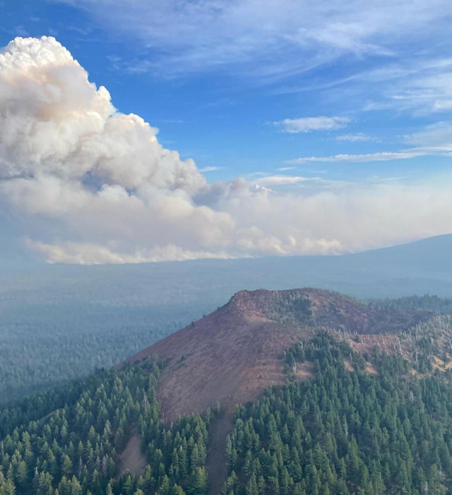
BEND, Ore. (KTVZ) -- The Bachelor Complex of 30-plus fires, dominated by the 10,000-acre Little Lava Fire, broke out nearly a week ago, and a weather change in recent days has prompted some lower evacuation levels left fire officials feeling optimistic about the road ahead.
Made up of 30 different fires, the Bachelor Complex has now burned 10,333 acres, officials said Friday. Fire officials have not indicated any containment numbers yet, but the recent cooldown, some showers and higher humidities are allowing crews to shift from a defensive to offensive strategy.
"Just cooler temperatures, a little bit of precipitation. The humidity will be a little bit lower in the next couple of days. So there may be an uptick of hotter burning," said Misti-Kae Bucich, a public information officer with Pacific Northwest Incident Management Team 3. "But the the humidity was higher, and so humidity levels have been adjusting, shorter days - all of that stuff works in our favor."
The 365 personnel on the ground are also mopping up and putting out hot spots. Firefighters engaged Thursday in prescribed burning to remove some fuel. That effort, coupled with previous prescribed burns are helping prevent further spread.
Continued progress on the Little Lava Fire led to some reduced evacuation levels for nearby residents and businesses on Friday, with Mt. Bachelor being placed in "normal" status, allowing fall operations to resume Saturday, a week after the lightning-sparked fire began.
Mt. Bachelor Communications and Community Relations Manager Presley Quon said Friday afternoon, "Our team sends a heartfelt 'thank you' to the firefighters and crews that have been working around the clock to contain the fires and protect our community. Their dedication and hard work are truly commendable."
To view their fall operating schedule, click here. Check the Mountain Report for real-time operations updates and weather.
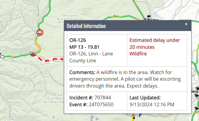
Meanwhile, ODOT confirmed that state Highway 126 west of Sisters and south of Santiam Pass reopened Tuesday afternoon with a pilot car guiding traffic, three days after the Boulder Creek Fire prompted its closure. A 20-mile stretch of nearby state Highway 242, the McKenzie Pass Highway, is still closed due to the Linton Creek Fire.

Here's the Deschutes County Sheriff's Office update at midday Friday:
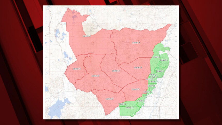
Within continued progress on the Little Lava Fire and other fires in the Bachelor Complex, fire managers are recommending slight changes in the evacuation areas.
All areas expected to remain as is for the weekend, except:
- Deschutes National Forest immediately adjacent to the Deschutes River north of FS Rd 40 (Spring River Rd), east of FS Rd 41 (Conklin Rd), and South of Benham Falls is being reduced to Level 1: Be Ready.
- Mt. Bachelor is being reduced to normal status.
- All other evacuations will remain in effect.
FS Rd 40 will remain closed west of FS Rd 41.
Please abide by forest closures in effect, which are available at the Deschutes National Forest website. These are in place for community and firefighter safety and to avoid conflicts with fire operations.
Current maps including evacuation areas can be found at:
https://deschutes.org/emergency
For fire information, you can visit the Central Oregon Fire Information site at:
--
Bachelor Complex Fires, Flat Top and Firestone Fires
Publication Type: News - 09/13/2024 - 12:25
Northwest 3 Complex Incident Management Team
Lonnie Click ~ Incident Commander
September 13, 2024
Bachelor Complex and Flat Top and Firestone Fires Update
Quick Facts: Bachelor Complex
Size: 10,333 acres Start Date: Sept 8 Location: Mt Bachelor, 20 miles SW Bend, OR
Personnel: 365
Quick Facts: Firestone & Flat Top Fires
Firestone Size: 8,787 acres Start Date: Sept 6 Location: North of Fort Rock, OR
Flat Top Size: 30,643 acres Personnel: 159
Yesterday, firefighters continued to establish containment lines on the Bachelor Complex, Flat Top and Firestone Fires. Throughout the afternoon, air tankers and helicopters continuously dropped water and retardant to slow spread on the Flat Top Fire. Firefighters conducted strategic burning operations on the Little Lava, Flat Top, and Firestone Fires which saw an increase in smoke production later in the day. Crews also worked night shifts to patrol and secure these areas.
The Deschutes National Forest expanded their temporary closure areas on Thursday afternoon and the updated closure areas include additional developed recreation sites. A recording from Wednesday’s public meeting has been posted to Facebook: facebook.com/deschutesnationalforest/.
These are priority fires in the region and more personnel, heavy equipment and aerial resources continue to arrive to support suppression efforts. Today, the fires were assigned a dedicated air attack to coordinate aerial suppression operations. Firefighters will continue to establish and secure containment lines and conduct tactical burning operations around the Bachelor Complex, Flat Top and Firestone Fires.
Bachelor Complex: The higher elevation fires in the Bachelor Complex near the Cascade crest have experienced minimal fire growth over the last two days due to cooler temperatures, higher moisture levels and good overnight humidity recovery. As moisture levels drop and temperatures rise today and Saturday, expect to see more smoke along the edges of these fires. Yesterday, firefighters completed burning operations to the south of the Little Lava Fire to Forest Service Road (FSR) 4525. Crews continued to mop up and secure the portion of the fire east of FSR 45. Today, firefighters will scout for opportunities to establish a control line north of this fire to Edison Trail. On the Backside and 911 Fires, crews will continue to strengthen containment lines and mop up operations.
Flat Top Fire: As humidity levels dropped yesterday afternoon, grass and brushy fuels became available for ignition and the Flat Top Fire saw increased fire activity, with flanking to the north. Firefighters used retardant drops ahead of dozers line to keep the fire from spreading. Today, firefighters plan to continue strategic firing operations on the ground to help secure control lines along the north and northeast sides of the fire. This will result in increased smoke production over the fire.
Firestone Fire: Yesterday, firefighters conducted burning operations along the southern and southwestern flanks of the fire near the base of East Butte to Forest Service Road 220. Today, crews will prep roads south and southeast of the fire in preparation for potential burning operations in the coming days.
Safety: With increased fire traffic, everyone in the area is reminded to drive slowly and carefully on road systems near the fire suppression operations. If you don’t need to be in the area, please stay clear to allow firefighters plenty of time and space to work.
Weather and Fire Behavior: The Bachelor Complex fires will dry out a little with temperatures today and Saturday in the mid-60s. This afternoon, west winds could gust up to 18 mph. The Little Lava Fire may see some flanking fire and individual tree torching this afternoon with low rates of spread.
On the Firestone and Flat Top Fires, moisture levels will drop and are expected to reach 20-25% relative humidity this afternoon with warm weather in the mid-70’s. West winds will pick up this afternoon with gusts up to 15 mph. These conditions may result in increased fire activity. Cool temperatures from a system coming up from Northern California are forecasted beginning early next week as well as an increased chance for wetting rain. Currently, there is potential for isolated thunderstorms Sunday night.
Evacuations: Emergency management and fire officials are closely coordinating and adjusting evacuation levels as needed. Level 3 evacuations mean “Go Now,” Level 2 means “Be Set,” and Level 1 means "Be Ready.” To view current evacuation levels, please visit the Deschutes County Emergency Information Interactive Map at: http://www.deschutes.org/emergency. For Lake County evacuation information, please visit: https://www.lakecountyor.org/flat_top.php
Closures: There are two closure areas on the Deschutes National Forest for these fires. Both closure areas were expanded on Thursday, September 12, and include additional developed recreation sites. View the updated closure orders and maps on the Deschutes National Forest site at: https://www.fs.usda.gov/alerts/deschutes/alerts-notices.
Facebook:
https://www.facebook.com/deschutesnationalforest/
InciWeb:
https://inciweb.wildfire.gov/incident-information/ordef-bachelor-complex-fires
https://inciweb.wildfire.gov/incident-information/ordef-flat-top-and-firestone-fires
YouTube:
https://www.youtube.com/@CentralOregonFireInfo?app=desktop
