USFS proposes 35,000-acre treatment project S. of Bend
Mix of thinning, fuels reduction for resilience to wildfire, insects, disease
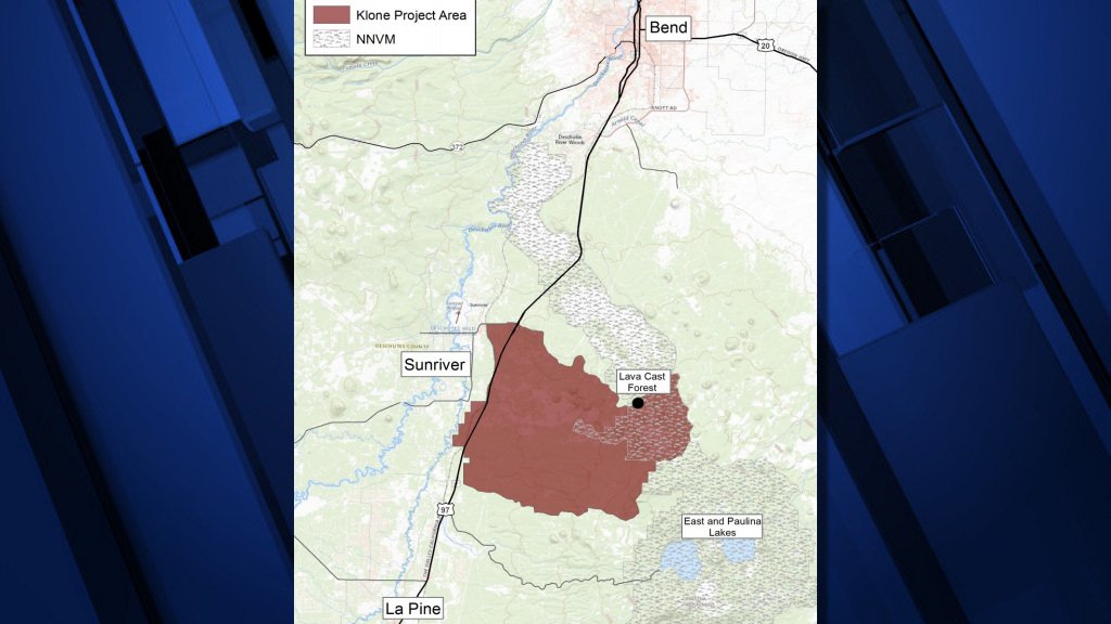
BEND, Ore. (KTVZ) -- The Deschutes National Forest's Bend-Fort Rock Ranger District went out for public comment Thursday on a project to conduct thinning, fuels reduction and other work on nearly 35,000 acres south of Bend and east of Sunriver.
The Klone Vegetation Management Project extends from Forest Road 9720 on the north to Forest Road 9735 on the south.
"The purpose of the project is to improve forest resilience against uncharacteristically large disturbance events such as wildfire, insects, and disease through treatments such thinning and fuels reduction," the announcement said.
Maps, explanations of the proposed actions, and information on how to comment are included in the scoping letter, located on the Deschutes National Forest website at http://www.fs.usda.gov/project/?project=57735.
Just over 10,000 acres on the west side of the area are located in the wildland-urban interface designated by the Upper Deschutes River Community Wildfire Protection Plan. About 5,800 acres are within the Newberry National Volcanic Monument.
The only recreation sites and trails in the area are the Lava Cast Forest and Hoffman Island trails. Relatively recent (6,000-8,000-year-old) lava flows cover nearly 3,700 acres and forested lava is present throughout the area.
The area is south of two other vegetation management projects currently being implemented.
"Treating in the Klone project area would create landscape-scale continuity of more resilient forests along the east side of Highway 97 south of Bend," the scoping letter states.
"Past management activities, such as fire exclusion and selective harvest of large, fire tolerant trees, disrupted the role of fire as an important disturbance agent in the Klone project area," it states.
"Currently, high fuel loads, abundant ladder fuels and brush, and increased tree densities are widespread across the project area. Lodgepole pine and white fir are encroaching on stands once dominated by fire tolerant Ponderosa pine."
"High tree densities also makes stands more susceptible to insect and disease infestations," they added.
Since 1980, the area has averaged 4-5 wildfires a year, both from lightning and human causes. In August 2017, the 1,221-acre McKay Fire started south of Forest Road 9735 and burned into the project area "at an uncharacteristically high intensity, which resulted in high tree mortality," the letter states.
Commercial thinning is proposed on 9,865 acres, along with 9,200 acres of pre-commercial thinning and 1,142 acres of ladder fuels reduction. Prescribed burning also is proposed, including 12,530 acres of underburning.
Comments are sought by April 6. For more information, contact Cristina Peterson, NEPA Planner, at cristina.peterson@usda.gov or 541-383-4028.