Cleanup, power restoration underway from damaging storm in Culver, Jefferson Co.


(Update: Info from Jefferson County emergency meeting)
CULVER, Ore. (KTVZ) -- Cleanup and repair efforts were underway in earnest Sunday after violent thunderstorms tore through areas of Central Oregon, especially Culver and Jefferson County.
Jefferson County commissioners held an emergency meeting online Sunday afternoon for a status report.
Sheriff Jim Adkins said the American Red Cross was notified, but turned out not to be needed in the hard-hit areas.
"Sounds like only a few heavily damaged homes," he said. "God took care of us, considering the magnitude of the storm."
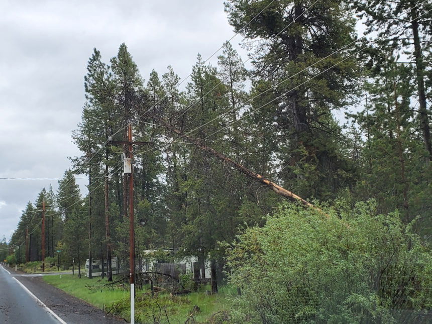
Pacific Power representative Matt Chancellor said the storm took down or damaged 30 distribution poles and nine transmission poles. Portland General Electric had damage to five of the large 500-kilovolt transmission structures that usually withstand all but the worst conditions.
About 3,700 Pacific Power customers were still without power Sunday afternoon, but utility crews, some brought in from southern Oregon and the Willamette Valley, expect to have many restored by 8 p.m. Sunday and others by midnight.
Culver City Recorder/Manager Donna McCormack noted "extensive damage" in the city while Metolius City Clerk James Stratton said there was damage to 40-50 homes and vehicles.
Culver Mayor Nancy Diaz.said she and her husband had been out helping residents and "it's been a blessing" to see others doing much the same. Another suggestion was waiving transfer station fees for storm debris, now being left in the streets by many as they clean up.
A large mudslide that blocked Pelton Dam Road and was cleared by midday Sunday was discussed by Undersheriff Marc Heckathorn and others, along with issues such as power out to Opal Springs Water Co. and whether any restrictions for area water supplies such as outside lawn-watering were needed.
Cove Palisades State Park Manager Todd Honeywell reported major damage with many trees down, especially in the area of the Crooked River Campground, day-use area and marina. Several dock systems broke free from the shore at their connections.
State Rep. Daniel Bonham and state Sen. Lynn Findley offered whatever help they can, both with cutting red tape for assistance to something more direct: "I own a chainsaw, I've got a truck," Bonham said. Findley said he, like all others, are thankful there were no serious injuries.
Crooked River Ranch resident Kate Adams said they and much of the area had power restored after about 24 hours and expressed thanks to Pacific Power, but noted about 500 still were waiting for power.
Earlier story:
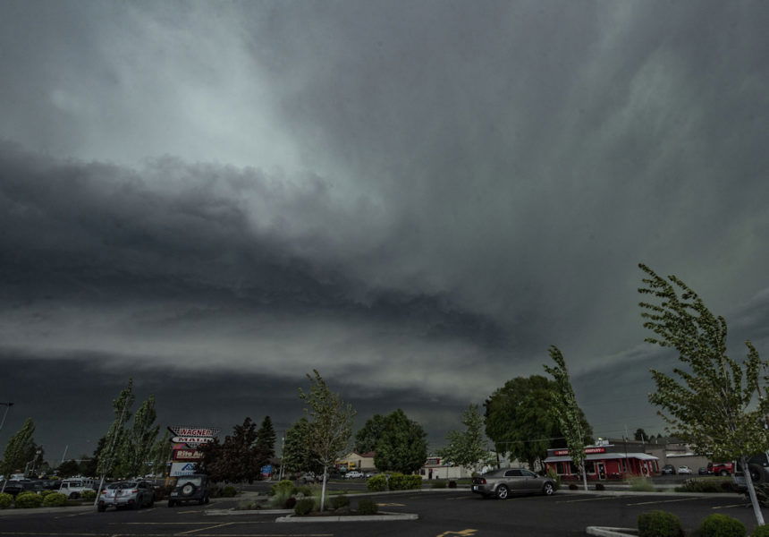
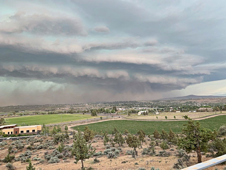
BEND, Ore. (KTVZ) -- As predicted, much of Central Oregon was rocked by several severe thunderstorms Saturday afternoon that dropped large hail, brought winds gusting up to 85 mph and toppled many trees, some into homes and across roads, while downed lines cut power to thousands.
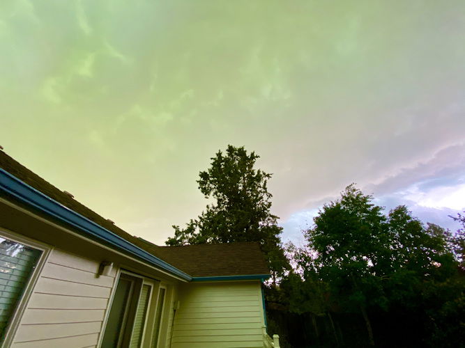
Many residents noticed an eerie green tinge to the darkened sky as the storms approached and rumbled through with flashes of lightning, thunder and heavy rain, hail or a mix. Several residents over a wide area said it was the largest hailed they'd ever seen.
A National Weather Service storm spotter reported two-inch-sized hail nine miles southeast of Sisters and another reported 1 ¾-inch hail nine miles northwest of Terrebonne, in Jefferson County.
An NWS spotter reported winds gusting to 85 mph south of Madras, where several large trees were down and farm equipment damaged along Highway 97.
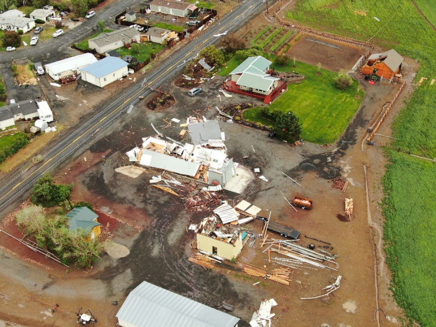
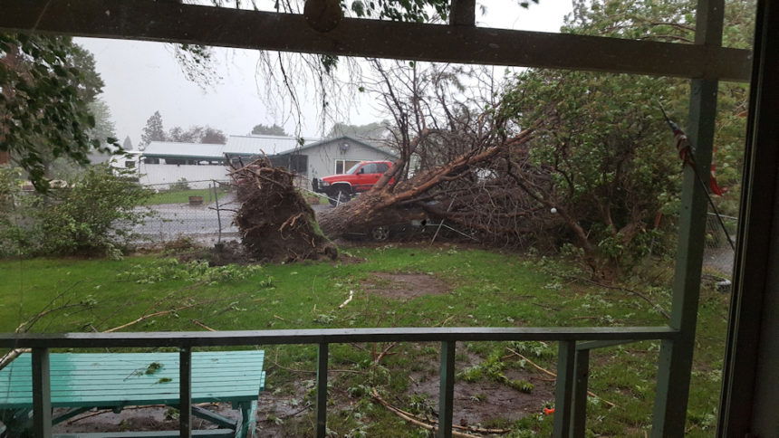
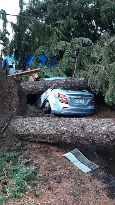
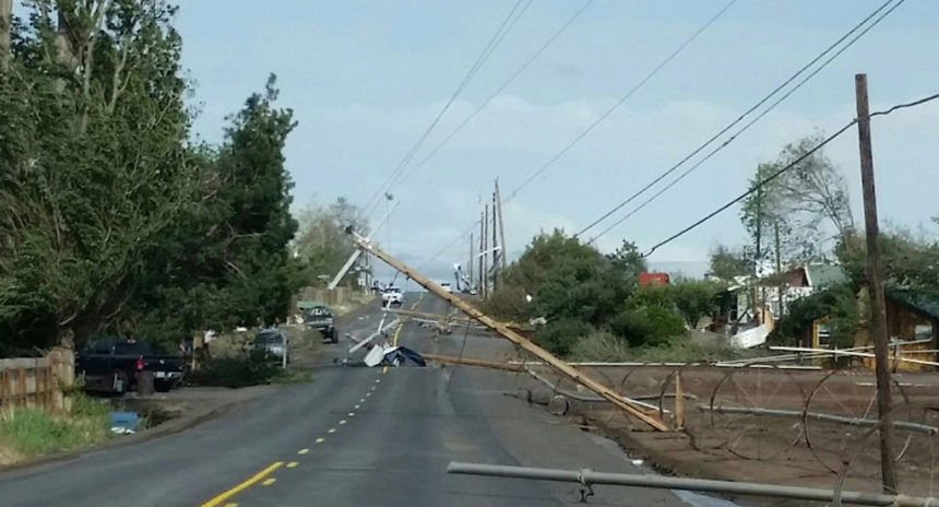
Damage was heavy in Culver, area residents said, with many power poles down on Iris Lane and other streets, barns and hay sheds destroyed, trailers overturned and items from silos to portable toilets flung hundreds of yards.
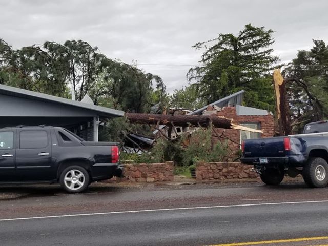
"I can see shingles ripped off house after house, " former Madras Mayor Rick Allen said, along with "trees that look like locusts ate all the leaves." The Metolius and Madras areas also had damage from the storm.
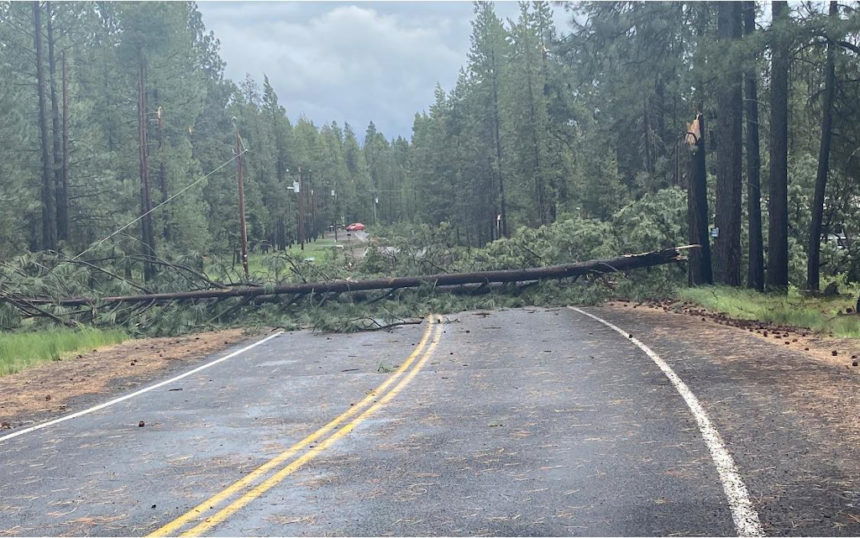
Deschutes County sheriff's deputies reported dozens of downed trees and power lines in the south county. "Use caution if traveling and please don’t touch any tree or object that may be in contact with a live power line," they warned on the agency's Facebook page.
A Sunriver resident said seven trees came down around her property and many more across the resort community.
Sunriver Fire Captain Benjamin O'Keefe said a two-foot-diameter tree smashed through the roof of an occupied home on Timber Lane, with no injuries reported, while another tree about the same size did the same to an unoccupied home on Pro Staff Lane.
Winds gusting to 60 mph or more hit the Culver area especially hard, with area residents reporting numerous trees and power lines down, pivots turned over, irrigation wheel lines across Highway 97.
Iris Lane was blocked by downed lines at Highway 361 (the Culver Highway), initial scanner reports indicated.
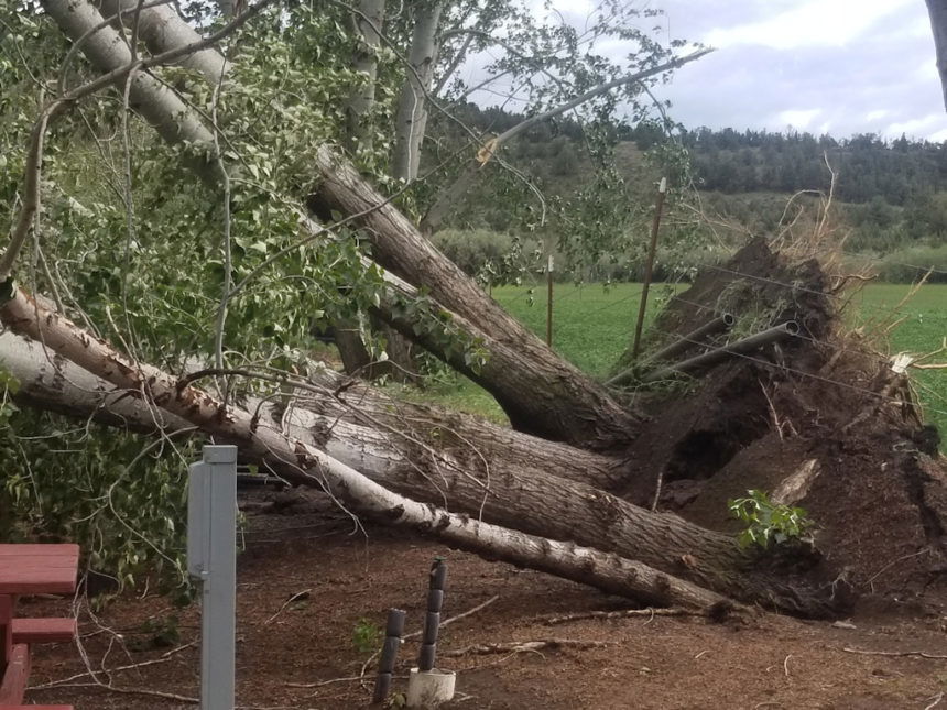
Numerous Culver-area residents who witnessed the severity of Saturday's damage thought it was a tornado, or something like it.
But was it?
NWS-Pendleton meteorologist Marc Austin told NewsChannel 21, "I wouldn't rule it out," but the evidence they'd seen so far doesn't prove it.
"That storm was definitely rotating," he said. "It was a super-cell thunderstorm. We've had a few of those today. But not all super-cell thunderstorms create tornadoes that reach all the way to the ground."
"You can have a rotating storm that doesn't produce a tornado," Austin said. "Sometimes, winds can undercut the potential for tornadoes, too."
Later Saturday night, after seeing some of the video and photos of the damage shared with NewsChannel 21, Austin said, "It certainly looks suspicious, but … a photo doesn’t allow us to discern rotation."
"There was a lot of dust blowing out ahead of the storm," the meteorologist said. "We’re going to investigate further in the next couple of days to confirm whether there was a tornado or not."
Austin said people can share photos or other evidence by email to pdt.operations@noaa.gov.
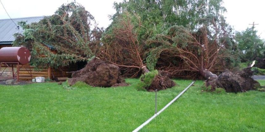
Jefferson County residents also shared photos of very large trees toppled all in a row, which Austin said usually indicates "straight-line wind damage." Many people shared images of ripped-off roofs, and others of a home in Metolius severely damaged by a fallen tree.
Law enforcement and firefighters were rushing from one trouble to another as reports of damage or road blockages kept 911 dispatchers busy. A Crooked River Ranch resident said the storm's winds tore the roof off his home.
Crook County 911 said on its Facebook page they had reports of several power lines and trees down across the county, with several roads blocked. A Prineville weather spotter reported a 30-foot-tall tree was blown down.
Toppled trees, power poles and lines caused numerous power outages. More than 9,600 Pacific Power customers were out across the region around 3:30 p.m., with the largest outages nearly 2,700 around Prineville and about 2,000 in more than a dozen outages around Bend, according to their outage page.
There were still about 7,600 customers without power at 8:45 p.m., mostly in the Crooked River Ranch and Culver areas.
Almost 300 Midstate Electric Cooperative members were out of power, nearly 200 in the Three Rivers/Deschutes River Recreation Homesites area.
Lightning strikes also ignited trees and knocked out at least one power transformer, according to reports from across the region. Bend also saw heavy rain and hail in places, though blue sky was seen by late afternoon.
The lightning was accompanied by about a quarter to half-inch of rain, but firefighters still responded to four new small blazes. The largest was Incident 176, about a quarter-acre, atop Melvin Butte, with smoke visible from Eagle Crest and Sisters. Officials said an engine and crew was on the scene.
The Deschutes County Sheriff's Office earlier cited NWS reports of 70 mph winds and golf ball-sized hail south of La Pine as storms approached from the south. They urged caution and said to "have a plan to seek shelter if necessary.
The NWS had issued severe thunderstorm and flash flood watches for Central and Eastern Oregon through Saturday evening.
Forecasters who issued a flash flood watch from 1 p.m. through evening said "thunderstorms capable of torrential heavy rain are expected to blossom across Central Oregon and the eastern Cascades this afternoon, moving quickly north into central Washington."
"Rainfall rates as high as a half-inch to one-inch per hour are possible with storms that will ultimately congeal as they exit north central Oregon into Washington late today and this evening," the watch stated.
A severe thunderstorm watch also was issued for the region through 7 p.m.
Forecasters said flash flooding will be possible, especially in areas of complex terrain and low-lying areas, with rises also possible in nearby rivers and streams, they said. Flash flooding or debris flows also will be possible with recent burn scars.
"Flash flooding is a very dangerous situation," forecasters said. "You should monitor later forecasts and be prepared to take action, should flash flood warnings be issued."