More progress seen on Central Oregon wildfires
BEND, Ore. (KTVZ) -- The more than week-old lightning-sparked wildfires burning across Central Oregon are again seeing higher containment figures Wednesday, thanks to hundreds of firefighters on the lines and in the air.
Here are Wednesday's fire updates:
Green Ridge Fire
August 26, 2020 AM Briefing
https://www.facebook.com/Green-Ridge-Fire-Oregon
Green Ridge Fire Information: (541) 604 8461; staffed 8:00 a.m. to 9:00 p.m. daily
Web: https://inciweb.nwcg.gov/incident/7012/ email: greenridgefire2020@gmail.com
| Size as of IR flight: | 4,348 |
| Containment: | 23 % |
| Start Date/Time: | August 16, 2020 5:05 p.m. |
| Location: | Camp Sherman, OR |
| Cause: | Lightning |
| Personnel: | 749 |
| Assigned Resources: Hand Crews: Engines: Dozers: Water Tenders: Other Heavy Equipment: | 25 22 5 10 7 |
| Assigned Aircraft: Structure Task Forces: | 6 0 |
| Injuries: | 0 |
| Structures Threatened: | 108 |
| Structures Damaged: | 0 |
| Structures Destroyed: | 0 |
| Evacuations: | Level 1 issued for areas on east and west sides of fire |
| For the most current evacuation information, contact the Incident Management Team Information Section (541) 604 8461 staffed 8:00 a.m. to 9:00 p.m. daily |
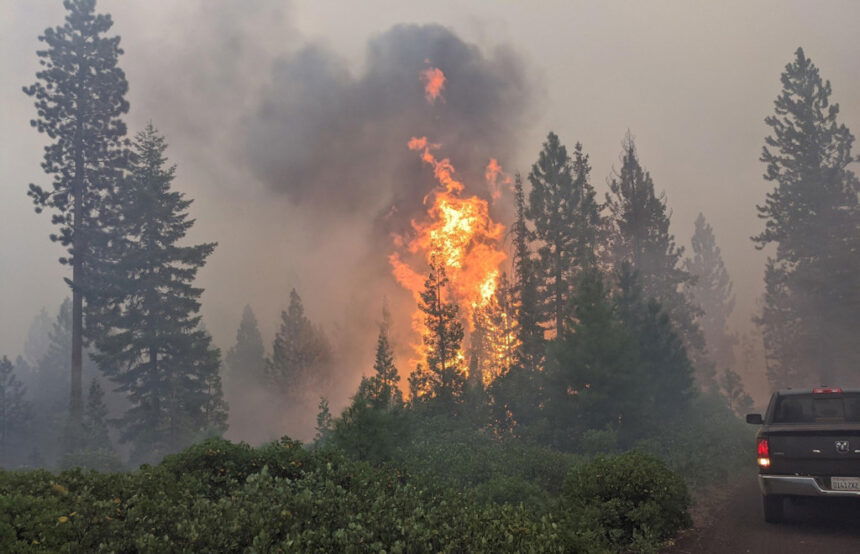
Camp Sherman, Ore. – Fire lines held again yesterday on the Green Ridge Fire and crews continued mopping up hotspots. One area on the north side and one area on the east side are challenging efforts. On the north side, crews continue to find and contain spot fires in a location dubbed “the honeycomb” due to the number of areas where embers have ignited small fires outside the line. On the east side, crews are working to mopup a large section of line where the fire burned in a mosaic pattern, leaving pockets of vegetation that could reignite. Twenty-five hand crews and 22 engines will continue mopping up today, supported by numerous dozers, water tenders and other heavy equipment.
Mopup on a wildfire is a multiple stage process. Before firefighters can start looking for hotspots, they need to identify and mitigate hazard trees. Falling snags are one of the top causes of injuries and fatalities for wildland firefighters. At the same time, crews extend hoselays up the line. While firefighters can extinguish hotspots by stirring in cooler dirt to the hot embers, having water greatly improves the speed and effectiveness of the process. Once a hotspot is cool to the touch, crews move on to the next one. This process will continue until crews have located and put out all of the hotspots within a recommended distance from the containment line, which can vary by fire.
The Level 1 Evacuation notices for residences around the fire and the Deschutes National Forest Area Closure remain in place. FS Road 14 and associated campgrounds remain open. For information about evacuation notices and Forest Area Closures go to: https://inciweb.nwcg.gov/incident/7012/
ODF Team 3 remains committed to the safety of the public and wildland fire personnel. All fire personnel are expected to follow recommendations from the Centers for Disease Control for preventing the spread of COVID-19.
Frog Fire Update
Northwest Incident Management Team 8, Incident Commander, Doug Johnson
August 26, 2020 - 9:00 AM
The safety of the public and all wildland fire responders is always the number one priority for all wildland fire agencies. To keep firefighters and communities healthy and safe, all firefighters are asked to follow recommendations from the Centers for Disease Control and Prevention to reduce the spread of illness. This also includes limited entry into the incident command post and spike camp. Please see the websites below or contact the Frog Fire information center at 541-670-0812 for further fire information.
General Updates: Yesterday provided favorable weather conditions for firefighters to strengthen control lines around the perimeter of the fire. The anticipated thunderstorms stayed southeast of the fire. Due to moderate cloud cover, fire behavior remained minimal through much of the day with the fire smoldering in unburned ground debris and continuing consumption of downed trees.
Mop-up operations continued with firefighters achieving 50 to 200 feet of cold ground inwards from the fireline. Crews are utilizing an extensive hose lay on the northwest side of the fire where bluffed, steep terrain has proved challenging. They conducted successful cold-trailing, the process of gridding an area by hand to feel for spots of heat, and mop-up operations in this area yesterday.
Today firefighters will continue mopping up across the fire and working on rehabilitating areas impacted by fire suppression. Fire resources are also looking for opportunities to backhaul unneeded supplies and garbage from the fireline.
The western flank has been more accurately mapped increasing the total acreage.
Acreage: 4,020
Containment: 45%
Fire Information: 541-670-0812 (8:00 am to 9:00 PM)
E-mail: FrogWildFire2020@gmail.com
Information Websites:
Twitter: @CentralORFire
Blog Site: http://www.centraloregonfire.org
Inciweb: http://inciweb.nwcg.gov/incident/7036/
Smoke: oregonsmoke.blogspot.com
Weather: Sunny in the morning followed by a few small cumulus buildups during the afternoon. A slight chance of showers or a thunderstorm south and east of the fire. Temperatures 80-85, minimum Rh 15-20%, winds 2-5 mph from the south becoming 4-8 mph from the northwest with gusts up to 13 mph in the afternoon
Air Quality: Prineville, Redmond and Bend remain at a moderate level. Moderate air quality is acceptable; however, people who are unusually sensitive could experience respiratory symptoms and may need to take precautionary measures. Smoke sensitive individuals are advised to stay inside whenever possible. A detailed smoke forecast for Oregon is available at oregonsmoke.blogspot.com.
Resources-482: 3-type 2 initial attack crews, 11-type 2 crews, 1-light helicopter, 20-engines, 3-skidgines, 2-dozers, 13-water tenders, and miscellaneous overhead
Evacuations: None
Closures: Several road closures and an area closure have been implemented near the Frog Fire.
The Crook County Sheriff’s Office has closed the following roads:
On the south end:
· Roberts Road at Bear Creek
· Klootchman Creek Road at Bear Creek
· Salt Creek at Roberts Road
On the north end:
· Forest Service Road 16 at the junction of Forest Service Road 1610
A temporary area closure has been implemented by the Ochoco National Forest. For a full description and map of the area closure, please see the above Inciweb link.
Temporary Flight Restrictions: For the safety of firefighters and aircraft fighting the Frog Fire, a temporary flight restriction has been placed over the fire area. Please consult the Notice to Airmen for specifics.
Warm Springs fires update:
Quick Facts
Incident Summaries
P-515 / Lionshead
Approximate
Size in Acres: 4,609 ac./3,059 ac.
Fire
Containment: 50% / 8%
Incident
Commander Eric Knerr
Resources
on the fire:
Crews: 22
Helicopters: 11
Engines: 21
Water Tenders: 9
Dozers: 7
Heavy Equip: 7
Total
Personnel: 750
Jurisdiction: Confederated Tribes
of Warm Springs
Oregon Smoke Blog
http://oregonsmoke.blogspot.com/
InciWeb
https://inciweb.nwcg.gov/incident/7050/
https://inciweb.nwcg.gov/incident/7049/
Update-August 26, 2020
For Immediate Release
Incident Commander: Eric Knerr, Northwest Team 7 Fire Information: 971-277-5075
Warm Springs, Oregon: This update is for the P-515 Fire and Lionshead Fire burning on the Warm Springs Reservation. Both fires are being managed for full suppression.
Current Situation: The P-515 Fire is now 4,609 acres and 50% contained. Yesterday, minimal fire activity allowed crews to make good progress on securing the fire perimeter, with mop up occurring in all divisions.
The Lionshead Fire is now 3,059 acres and 8% contained. Spot fires on the south side of Whitewater River moved east up slope towards the J-100 road. Firefighters conducted a successful burn-out operation ahead of the advancing fire front on portions of the J-200 road. Fire managers were pleased with the progress made on the direct and indirect line along the P-440 road on the northern flank.
P-515 Fire: Today, resources plan to focus their mop-up efforts on concentrated sources of heat near the perimeter of the fire. Firefighters will work to secure and improve the depth of mop up operations on all flanks and identifying locations for fire suppression repair work.
Lionshead Fire: Firefighters will continue direct and indirect burn out operations to better secure the northern flank. The intent of the strategic burn out operation along the J-200 road is to remove pockets of fuel prior to the fire reaching the road as a point to hold the fire. Crews on the southern flank will prep other sections of the J-200 road for ongoing firing operations.
Weather and Fire Behavior: Both fire behavior and weather will be similar to yesterday. We expect down valley winds (east) 2-7 mph in the Whitewater River drainage with gusts up to 12 mph. Temperatures in the 70’s, and humidity in the upper teens are forecast for today. Flare-ups are likely in unburned fuels near control lines and there is a potential for group torching in heavy fuels under tree canopies.
Closures: Trout Lake Road at pavement end; Road B140 at Potter’s Pond; Road B210 and Road P-500.
All trails south of Trout Lake, west of M-120 Metolious Bench, east of Mt. Jefferson, and north of J-195 will be closed to the public. Also, Tenino Road (P-200) will be closed to the public, only fire personnel and residents are allowed on Tenino Road (P-200).
Evacuations: A Level 1 Evacuation (Get Ready) is in effect for residents on Trout Lake Road west of US-26.
COVID-19: Precautionary measures have been implemented to prevent the spread of COVID-19. These measures include daily temperature screenings, mandatory use of face coverings, social distancing, and implementing more virtual work. Public and firefighter safety are a top priority.
Prevention Message: Do your part to help our heroes.
Steet Mountain Fire/Laurel Fire
August 26, 2020 9:00 am
Size:
Steet Mtn Fires
Laurel Fire
699 Acres
1,257 Acres
Containment:
Steet Mtn Fire
Laurel Fire
85% - Combined
40%
Start Date: August 18th, 2020
10:00pm
Location:
Steet Mtn Fire
Laurel Fire
Near Monument
6 miles S of Spray
Cause: Lightning
Est. Cost: $2,100,000
Personnel: 336
Resources: 1 Camp Crew
10 Hand Crew
15 Engines
5 Dozers
5 Water Tenders
3 Skidders
Aircraft: 1 - Type 2 Helicopter
2 - Type 3 Helicopter
Evacuations: None
Structures
Threatened:
4—hunting cabins on
Laurel fire
Structures
Damaged: 0
Structures
Destroyed: 0
Closures: None
Email contact—SteetMtnComplex.LaurelFire@gmail.com
Public Information Line: (541) 604-8483
Steet Mountain Fire—https://inciweb.nwcg.gov/incident/7039/
Laurel Fire—https://inciweb.nwcg.gov/incident/7037/
Fire Summary:
Today, fire crews continue to work extinguishing hot spots and mopping up. Air resources will continue to provide support to ground crews
with water drops. Crews will strengthen the fire lines and locate and
deal with hazard trees and hot spots within 150 feet of the fire line.
With fire lines holding for the past three days, we do not anticipate the
fires to grow.
Final acreage for the fires are:
Steet Mountain Fire - 477 acres
Cochran Fire - 88 acres
Two Cabin Fire - 97 acres
Conger Fire - 15 acres
Troff Canyon Fire - 0.2 acres
Jones Canyon Fire - 0.25 acres
Three Mile Creek Fire - 22 acres
Laurel Fire - 1,257 acres
Continued support provided by the local communities has helped with
suppression efforts. Firefighter and public safety are our highest priority during this incident, including COVID mitigation.
