Lionshead Fire, at 204K acres Oregon’s largest of year, nears 50% containment
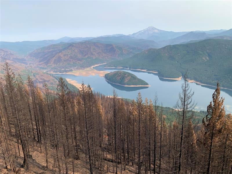
SALEM, Ore. (KTVZ) -- The more than 204,000-acre Lionshead Fire, sparked by lightning west of Warm Springs in mid-August, is approaching 50% containment, the last of Oregon's major wildfires to do so, officials said.
The Oregon Department of Forestry said Monday is closely tracking six major fires in Oregon, down from 17 originally (see table below for details). Fires are removed from the list when they are 100% lined and fire managers are confident in their progress toward containment.
Five of the six major fires still on the landscape have burned 100,000 acres or more in Oregon. One of those massive fires, Lionshead, is the sixth-largest fire of the past 100 years in Oregon, at 204,412 acres.
Lionshead is the only one of these major fires that showed any growth in size Sunday – just 27 acres. Most posted double-digit gains in containment over the weekend.
Sunday also saw no new fires reported anywhere in the state. But ODF urged Oregonians to remember that fire season isn’t over yet, which means backyard burning and other restrictions are still in effect on ODF-protected lands. Check the public fire restrictions map to see current restrictions for your area.
| Fire name | Acres burned | Containment | Location |
| Lionshead | 204,412 | 47.5% | 20 miles W of Warm Springs |
| Beachie Creek | 193,253 | 59% | 15 miles N of Detroit |
| Holiday Farm | 173,094 | 78% | 3 miles W of McKenzie Bridge |
| Riverside | 138,085 | 57% | 2 miles SE of Estacada |
| Archie Creek | 131,542 | 91% | 20 miles E of Glide |
| Slater | 44,597 in Oregon | 55% | 6 SE of Cave Junction (also in No. California) |
Closures
Santiam State Forest is still closed to the public. Before heading out to hunt or recreate on other state or federal public lands, please check to see if there are any restrictions or closures due to the recent fires. There are still portions of highways statewide that are closed. Use ODOT’s TripCheck to plan your route.
More information
- ODF wildfire blog and Significant Fire Potential Map
- Oregon smoke blog
- Northwest Coordination Center – Regional Update and National Situation Report
- Inciweb (information on individual incidents)
Confederated Tribes of Warm Springs Lionshead Fire Update
Monday, Oct. 5
Brian Gales, Incident Commander
Aaron Schuh, Deputy IC
| Start date: Aug. 16, 2020 | Containment: 47.5% | facebook.com/LionsheadFire |
| Fire size: 204,412 acres | Public information: 971-277-5075 | https://inciweb.nwcg.gov/incident/7049/ |
REDMOND, Ore. – Fire officials and representatives of the Stahlman Cabins community are discussing plans for residents’ reentry and crews are working with Mt. Hood National Forest personnel to make repairs and winterize the Olallie Lake Cabins.
On the reservation, firefighters are working to leave the homeland in the best condition possible when the fire is returned to local control. An archaeologist is being brought in to conduct a cultural survey of the 53 miles of dozer line and 10 miles of handline dug during the suppression effort before line rehabilitation begins. Water tenders assigned to the fire will be helping the tribe with road repair and grading work.
Sunday, monitoring crews hiked out to assess fire activity within islands of unburned vegetation in the northeastern corner of the fire, reporting it is at least 3,000 feet within the black -- a fire term for previously burned ground. Areas of active burning are also being monitored in the “finger” to the north.
Helicopters dropped water on several visible smokes to the southeast of Mt. Bruno, but had to stop when afternoon shadows made it too dark to fly safely. Smoke columns large and tall enough to see from a distance signify active burning. In inaccessible areas, water drops are used to cool the fire, slowing its progressing and reducing its intensity. That work will resume this morning.
Aviation also provided a Burned Area Emergency Response reconnaissance flight and is coordinating with various power companies conducting infrastructure assessments.
Suppression repair is ongoing across the fire footprint. One example is the installation of water bars on sloping fire lines and roads to help control erosion. Another is opening up the earthen berms created when bulldozers cut fire line and ensuring there are no live coals buried in them. Seeding equipment has been ordered to further stabilize soils on now-exposed ground.
Other work includes removing thousands of tons of downed trees and slash – branches, brush and other woody debris – along roads and rights-of-way. Once cleared, grading and repairing or replacing damaged culverts is needed in many areas. Hundreds of pumps, tools and other equipment must be gathered and returned to camp and accounted for. Aluminized structure wrapping must be removed and miscellaneous garbage is collected and disposed of.
Safety: Evacuees returning to their communities should remain alert, as many hazards remain. Soils may be unstable; ash can camouflage trip holes and trip hazards; hot embers may still be smoldering in stumps, roots and holes; and trees and branches weakened by fire can fall at any time.
Weather: Temperatures will be in 60s and 70s today, climbing higher into the 70s through Wednesday. A front is expected to bring cooler temperatures, higher humidity and potentially significant precipitation next weekend.
Evacuations: Evacuation levels remain unchanged for the communities on the west side of the fire. More information can be found at https://inciweb.nwcg.gov/incident/closures/7049/
