Green Ridge Fire Level 1 pre-evacuation alert widened to Lake Billy Chinook
(Update: New air quality advisory, Warm Springs fires update)
'Virtual public meeting' Friday evening; Frog Fire also growing
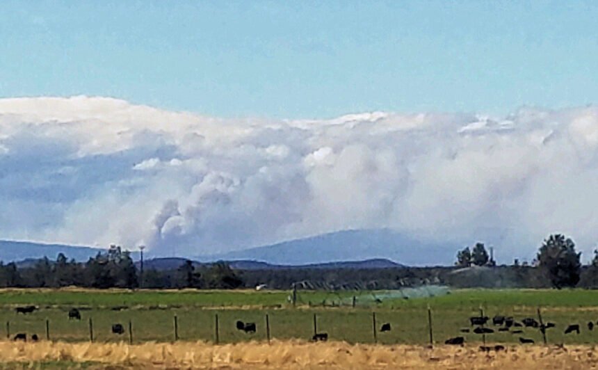
CAMP SHERMAN, Ore. (KTVZ) -- Friday afternoon winds kept the Green Ridge Fire growing, prompting a wider Level 1 pre-evacuation notice that now stretches north to Lake Billy Chinook.
Here's the late Friday afternoon statement issued by Jefferson County's Frontier 911 dispatch:
"A level 1 Evacuation Order is now in effect for the Lands in the Lake Chinook F.D., the 3 Rivers subdivision, Metolius Arm lake homes, Monty Campground and Perry South Campground.
"Residents should be aware of the danger that exists in their area, monitor emergency services websites and local media outlets for information. This is the time for preparation and precautionary movement of persons with special needs, mobile property and (under certain circumstances) pets and livestock. If conditions worsen, emergency services personnel may contact you via an emergency notification system
"Those persons who will need additional time to exit an area or have health conditions (especially respiratory conditions that could be made worse by smoke) should consider leaving now. You are encouraged to prepare or even move livestock and pets out of the area. Be prepared to leave if conditions worsen.
"This order is authorized by Sheriff Jim Adkins of the Jefferson County Sheriff's Office."
Approved Oregon Evacuation Levels
LEVEL 1: A Level 1 Evacuation means “BE READY” for potential evacuation. Residents should be aware of the danger that exists in their area, monitor emergency services websites and local media outlets for information. This is the time for preparation and precautionary movement of persons with special needs, mobile property and (under certain circumstances) pets and livestock. If conditions worsen, emergency services personnel may contact you via an emergency notification system.
LEVEL 2: A Level 2 Evacuation means “BE SET” to evacuate. YOU MUST PREPARE TO LEAVE AT A MOMENTS NOTICE This level indicates there is significant danger to your area, and residents should either voluntarily relocate to a shelter or with family/friends outside of the affected area, or if choosing to remain, to be ready to evacuate at a moment’s notice. Residents MAY have time to gather necessary items, but doing so is at their own risk. THIS MAY BE THE ONLY NOTICE THAT YOU RECEIVE Emergency services cannot guarantee that they will be able to notify you if conditions rapidly deteriorate. Area media services will be asked to broadcast periodic updates.
LEVEL 3: A Level 3 Evacuation means “GO” Evacuate NOW LEAVE IMMEDIATELY! Danger to your area is current or imminent, and you should evacuate immediately. If you choose to ignore this advisement, you must understand that emergency services may not be available to assist you further. DO NOT delay leaving to gather any belongings or make efforts to protect your home. THIS WILL BE THE LAST NOTICE THAT YOU RECEIVE Entry to evacuated areas may be denied until conditions are safe. Area radio and TV stations have been asked to broadcast periodic updates.
Earlier story:
BEND, Ore. (KTVZ) -- Hundreds of firefighters, including aerial resources, smokejumpers, engines and hand crews, were still busy across Central Oregon Friday as several wildfires grew larger and new ones were reported.
The Oregon Department of Environmental Quality issued an air quality advisory for Harney, Malheur and northern Deschutes counties Friday due to smoke from nearby wildfires.
An advisory for Jefferson County, Warm Springs and Lakeview areas also remains in effect, until at least Monday. DEQ and partner agencies will continue to monitor smoke in these areas.
Wildfire smoke was causing air quality issues in Madras, where the DEQ air quality monitors said the level was at unhealthy for sensitive groups, and Sisters, where it was moderate at midday Friday.
Here's Friday morning's full update on the now-nearly 3,600-acre Green Ridge Fire:
Agency Jurisdiction: Oregon Department of Forestry/USFS-Deschutes National Forest
| Email: 2020.GreenRidge@firenet.gov | Facebook: https://www.facebook.com/NorthwestTeam10 |
| Twitter: @CentralORfire | |
| Green Ridge Fire Information: https://inciweb.nwcg.gov/incident/7012/ | |
| Central Oregon Fire Information: www.centraloregonfire.org | |
| Fire Information Number: (541) 604 8461 |
| Date Started: August 16, 2020 | Acres: 3,590 |
| Cause: Lightning | Containment: 0% containment |
Announcement: A Public Meeting will be held at 6:00pm, PST, Friday, August 21, 2020 for the Green Ridge Fire. This meeting will be livestreamed to help meet recommendations for minimizing the spread of COVID-19. To join the meeting, go to Facebook https://www.facebook.com/NorthwestTeam10/live/
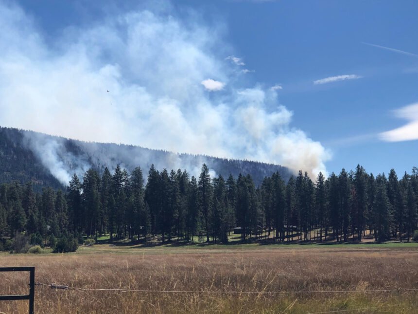
Yesterday, high afternoon winds pushed the fire across dozer lines on the eastern edge of the fire. Crews and dozers worked overnight to re-establish a line on the perimeter of the fire and firefighters will hold and improve this line today. Although cooler temperatures and higher relative humidity will help today’s efforts, sustained afternoon winds will continue to challenge existing fire lines to the east.
The fire continued to move slowly down the flank of Green Ridge on the western side of the fire. Due to steep slopes, hand crews will continue working to establish and hold containment lines on this portion of the fire, as well as improving the 1120 road to be used as the fire line. Burning material rolling downhill and across containment lines will continue to challenge these efforts. Helicopters will continue to support the ground effort with bucket drops, and heavy air tankers will be available if the fire is pushed outside of containment lines again today.
The fire remains staffed with almost 300 personnel including interagency hotshot crews, Type 2 initial attack crews, 20-person hand crews and numerous engines, dozers, skidgeons and masticators.
Public and firefighter safety is the top priority. Fire strategy includes stopping fire movement at the 1120 road on the western side of the fire, protecting private property, private timberlands, and any critical infrastructure within and adjacent to the fire perimeter.
There are no changes in the current Evacuation Notices and Forest Area Closures. For more information, please visit: https://inciweb.nwcg.gov/incident/7012/
For the safety of the public and wildland fire personnel, all fire personnel are expected to follow recommendations from the Centers for Disease Control and Prevention for preventing the spread of COVID-19. While federal agency guidance continues to adapt with the situation, NW Team 10 is prepared for wildland fire activity during this time.
Here's the 9 a.m. Friday update on the Frog Fire:
Prineville, Oregon – Northwest Incident Management Team 8 Incident Commander Doug Johnson, has assumed management of the Frog Fire as of 6:00 a.m. today.
The Frog Fire is burning in steep terrain in the Maury Mountains on the Ochoco National Forest, and on nearby private range and timber lands protected by the Oregon Department of Forestry as well as lands managed by the Prineville District Bureau of Land Management. Erratic winds remain a challenge for firefighters as fire behavior remains active in hot and dry conditions.
Last night, the fire made a push to the northeast and firefighters will concentrate efforts there today. Firefighters are looking for opportunities to hold the fire on preliminary containment lines but are challenged by several spot fires that have jumped over those lines.
Crews will continue to attack and suppress those spots while patrolling for new ones today along preliminary lines.
Crews were assisted by Single Engine Air Tankers (SEATs) and heavy air tankers laying down retardant to slow the spread of the fire while heavy helicopters cooled hot spots.
Infrared mapping was unavailable overnight so the acreage will remain the same estimated acreage as August 20 with no containment to report.
An area closure was put in place yesterday for all U.S. Forest Service managed lands west of Forest Road 17 in the Maury Mountains. This closure is being implemented for the safety of the public and firefighters working in the area.
Additionally, Crook County Sheriff’s Office has issued several road closures around the Frog Fire. On the south side of the Maury Mountain they include: Roberts Road at Bear Creek, Klootchman Creek Road at Bear Creek, Salt Creek Road at Roberts Road. Residents are encouraged to sign up for the Alert Crook County notification system at: www.alertcrookcounty.org.
Here is Friday's Warm Springs Fire update:
Incident Commander: Eric Knerr, Northwest Team 7
Fire Information: 541-553-2004
Quick Facts
Incident Summaries
P-515 / Lionshead
Approximate
Size in Acres: 3,615 ac./ 836 ac.
Fire
Containment: 5% / 0%
Incident
Commander Eric Knerr
Resources
on the fire:
Crews: 14
Helicopters: 1
Engines: 9
Water Tenders: 4
Dozers: 1
Total
Personnel: 530
Jurisdiction: Confederated Tribes
of Warm Springs
[Warm Springs, Oregon] This update is for the P-515 Fire and Lionshead Fire burning on the Warm Springs Reservation. Lightning has been determined to be the cause of both of these fires. These fires are 14 miles west of the Warm Springs community. An Incident Command Post has been established at the Jefferson County Fairgrounds. The Quartz Butte Fire is in mop-up with no new fire activity to report.
Suppression priorities include limiting the spread of the fires, protecting structures, and minimizing the impacts to important cultural and natural resources. The P-515 and Lionshead Fires are actively burning in areas of timber with grass, shrub, and patchy conifer understory. In many areas there are scattered snags and dense stands of young trees. Both fires are being managed for full suppression.
Current Situation: Yesterday, both fires exhibited rapid fire spread with spotting and increased acreage due to westerly winds. COVID-19 mitigations are being taken to limit exposure risks to firefighters and the tribal community, per CDC guidelines.
P-515 Fire: A Level 1 Evacuation (Get Ready) is in effect for residents on Trout Lake Road east of US-26. Crews began working to protect structures potentially in the path of the fire spread yesterday, and an Oregon State Fire Marshal’s Task Force has joined the structure protection effort today. Firefighters are seeking direct containment opportunities on the east side of the fire in order to keep it from reaching US-26.
Lionshead Fire: The Lionshead Fire is burning in the Whitewater River Canyon on the north side of the river. Firefighters are working to keep the fire on the north side of the Whitewater River Canyon, and stop the easterly spread of the fire. Access is difficult on the Lionshead Fire because of the steep terrain and limited road access.
Weather and Fire Behavior: A cold front is expected to cross the area with westerly winds gusting up to 30 mph. While temperatures and humidity are moderating, firefighters are expecting gusting winds to cause problematic fire behavior.
Road Closures: · Trout Lake Road at pavement end;· Road B140 at Potter’s Pond;· Road B210 and Road P-500.
Here's the full 8:30 p.m. Thursday update from Central Oregon Interagency Dispatch Center:
Initial attack resources worked on two new starts both reported a little after 3 p.m. Thursday. One fire (#754) was located on Kokostick Butte near the Sisters Mirror trail on the Deschutes National Forest. The other fire (#753) was located near Chimney Rock on lands managed by the BLM Prineville District.
The Frog Fire in the Maury Mountains on the Ochoco National Forest, about seven miles southeast of Prineville Reservoir, was actively burning Thursday and put up a large smoke plume that was visible from as far away as Bend.
With hot and windy conditions, the fire actively burned toward the east but was still mapped late Thursday at 3,700 acres.
Thursday afternoon, the Crook County Sheriff's Office implemented a road closure and the Ochoco National Forest implemented an area closure for both public and firefighter safety. For more information about those closures and the fire, the public can go to: https://inciweb.nwcg.gov/incident/7036/ .
A Type 2 Incident Management Team (D. Johnson) takes command of the fire at 6 a.m. Friday after receiving a briefing on the fire late Thursday afternoon. Weather conditions on the fire will continue to be hot and dry through the weekend.
The Green Ridge Fire again was pushed by high afternoon winds to the east onto private lands Thursday. With a smoke layer obscuring the perimeter, no new acreage figures were available Thursday night. The fire will be mapped overnight and a new map will be provided in the morning.
Information for the Green Ridge Fire can be found at: https://inciweb.nwcg.gov/incident/7012/. A video of Thursday morning’s briefing on the Green Ridge Fire can be found at: https://www.facebook.com/NorthwestTeam10/videos/1199501773745681/
The Lily Lake Fire on the Deschutes National Forest was reported to be 45 acres and 25% contained Thursday. Firefighters had hose lay around 75% of the fire Thursday morning, which is expected to help improve containment on the fire.
An area closure has been put in place for this fire: www.fs.usda.gov/alerts/deschutes/alerts-notices. Hikers along the Pacific Crest Trail can detour around the closure near Charlton Lake and FS Road 4290 to the south and the Irish and Taylor lakes area to the north.
The Laurel Fire, burning on private land and Prineville District Bureau of Land Management managed land about five miles south of Spray, grew to 1,300 acres and 8% containment.
Firefighters used bulldozers and engines on the fire, with the assistance of a private landowner. An Oregon Department of Forestry Incident Management Team will be taking over management of the fire, in coordination with the BLM Prineville District.
Hot and breezy conditions are expected to continue in the area of the fire, with continuing hot temperatures over the next several days.
The Hog Ridge Fire 12 miles northwest of Dayville remained at 350 acres and 10% contained Thursday. Throughout the day, mostly interior pockets of unburned fuel burned out, which allowed firefighters the opportunity to gain more control over the fire.
For up-to-date information on Central Oregon fires, visit www.centraloregonfire.org or www.twitter.com/CentralORFire
Virtual Public Meeting ~ Green Ridge Fire
The Northwest Interagency Incident Management Team 10 will hold a virtual public meeting at 6 p.m. PST, Friday, August 21. The meeting will be livestreamed to help meet the Governor of Oregon’s recommendations for minimizing the spread of COVID-19.
Presenters will include: Incident Commander - Alan Lawson, Deschutes National Forest, Sisters District Ranger - Ian Reid, Central Oregon Fire Management Service - Rob Pentzer, Team 10 Operations Chief - Steve North, Team 10 Fire Behavior - Forest Ownbey, Deschutes National Forest, Sisters Ranger District - James Osborne, Deschutes County Sheriff Office, Emergency Services Manager - Nathan Garibay, Jefferson County Sheriff Office, Emergency Services Manager – David, Pond, Oregon Department of Forestry, Area COVID Coordinator - Amber Ziring.
To join the meeting, please go to Facebook, https://www.facebook.com/NorthwestTeam10/live/
To participate, viewers do not need a Facebook account to view the meeting. The livestream will appear at the top of the Northwest Interagency Incident Management Team 10 Facebook page a few minutes before 6:00 p.m. Participants will have an opportunity to ask questions through Facebook about the Green Ridge Fire.
If you do not have the ability to connect to Facebook, the meeting will be recorded and saved on our Facebook page.
For members of the public unable to join the meeting via Facebook, information about the Green Ridge Fire will continue to be posted on fire information boards located in Sisters and the Camp Sherman area.
Green Ridge Fire Information
Agency Jurisdiction: Oregon Department of Forestry/USFS-Deschutes National Forest
Email: 2020.GreenRidge@firenet.gov
Twitter: @CentralORfire
Green Ridge Fire Information: https://inciweb.nwcg.gov/incident/7012/
Central Oregon Fire Information: www.centraloregonfire.org
Fire Information Number: (360) 319-6582
News release from the Oregon Dept. of Forestry:
Steet Mountain Complex
Laurel Fire
JOHN DAY, Ore. Firefighters from Oregon Department of Forestry’s John Day Unit have responded to numerous wildfires ignited by passing thunderstorms since Sunday afternoon. Most of these fires were caught during initial attack or a short extended attack. On Wednesday fire activity increased in the area on both ODF protected lands and on adjacent federal lands. These fires were primarily holdover fires from Tuesday’s thunderstorms which came with minimal rain. Dry fuels combined with hot temperatures allowed fires to grow rapidly Wednesday afternoon pushing both ground and air resources.
Some of these fires are continuing to spread today, but most have been caught and have fireline around the perimeter. There is significant work to be completed to secure the fires and mop-up the interior, in addition to suppression of the fires which continue to spread.
Today ODF’s Incident Management Team 2 (IC Cline) is being in-briefed by the Central Oregon District in preparation to assume command of seven fires later this evening. Six of the fires, burning on ODF protected lands, will be managed as a complex in the area around Monument, Oregon. The Steet Mountain Complex includes Steet Mountain (~860 acres), Cochran (~110 acres), Two Cabins (~80 acres), Conger (~5 acres), Troff Canyon (~.25 acres), and Jones Canyon (~.25 acres). The Team will also be managing the Laurel Fire (~2,000 acres), this fire is burning lands managed by Prineville BLM and ODF protected private lands six miles south of Spray in Wheeler County.
Bringing in ODF Team 2 to manage resources and suppression activities for these seven fires will free up local resources for initial attack on new fires and provide better coordination of resource needs on the fires. “We are really thankful to have the team come and help us with these fires,” District Forester Mike Shaw commented during the in-brief. “We know you guys have the capacity to quickly get these fires off the landscape and free up resources for other fires”.
Firefighter and public safety is the priority during this incident, including COVID mitigation. Personnel will be following Center for Disease Control guidelines to limit personal interactions both within camp and with the local community. The incident command post and fire camp are closed to the public.
Monitor ODF’s Central Oregon District social media (see side bar) for fire information updates.
