Lionshead Fire battle shifting focus; Deschutes Forest reduces area closure
(Update: Deschutes National Forest reopens some popular recreation, hunting areas)
WARM SPRINGS, Ore. (KTVZ) -- The 204,000-acre Lionshead Fire is still less than half-contained, officially, but much of the firefighting effort has shifted toward removing hazard trees and assessing burned areas.
Confederated Tribes of Warm Springs Lionshead Fire Update
Wednesday, Oct. 7
Brian Gales, Incident Commander
Aaron Schuh, Deputy IC
| Start date: Aug. 16, 2020 | Containment: 46% | facebook.com/LionsheadFire |
| Fire size: 204,435 acres | Public information: 971-277-5075 | https://inciweb.nwcg.gov/incident/7049/ |
REDMOND, Ore. – As additional portions of line are secured each day, more resources are focusing on removing hazard trees and slash, removing equipment from the fire line and conducting suppression repair work.
“Little things add up to big successes in terms of our tactical and strategic goals for the fire,” said John Spencer, operations chief trainee.
Burned Area Emergency Response assessments on the reservation have identified good burn mosaic – a mix of full burned, partially burned and unburned ground – in many areas. The fire burned with more intensity on the northeast corner and tribal personnel are still field verifying the extent of that damage.
Planning is under way to escort residents of the Stahlman Cabins and Sportsman Club to enter the area and retrieve belongings. In other work, Resource Advisors (READs) coordinated with engineers to develop a plan that will allow loggers to retrieve equipment from three harvest plots located in the interior of the fire.
Tuesday, crews finished clearing hazard trees and fire debris from around Detroit’s water treatment site and the intake from Breitenbush Creek, making it safe for work to resume.
Two helicopters dropped 72,000 gallons of water on Mt. Bruno and in the fire finger to the north. READs from Mt. Hood National Forest conducted a survey of Bull trout – which are listed as a threatened species -- along Pinhead Creek.
As resources move around the fire to work in different areas, firefighters take care to prevent the transfer of non-native or potentially invasive species.
For example, crews take care to clean their boots and pressure wash the undercarriages of equipment and vehicles to remove plants and seeds. Pumps, hoses and fish screens are also sanitized. Helicopter buckets are cleaned and sanitized before they begin dipping out of a new water source.
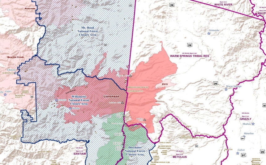
Closures: Most fire area closures remain in effect, but the vast majority of public lands managed by the USDA Forest Service and Bureau of Land Management that were closed as a precautionary action during the period of high potential for fire starts and rapid growth have reopened.
Hunters can visit https://myodfw.com/articles/2020-wildfires-impact-hunting-fishing-wildlife for information about hunt status, unit accessibility and more.
Weather: Winds are expected to pick up today and also change from a southeast-west trajectory to a southwest-west path.Temperatures will be in the 80s, then start tapering off to the low 50s by Saturday.
Evacuations: Evacuation levels remain unchanged for the communities on the west side of the fire. More information can be found at https://inciweb.nwcg.gov/incident/closures/7049/
News release from the Deschutes National Forest:
Deschutes National Forest Officials Further Decrease Lionshead Fire Closure
Revised closure allows increased access for hunting and recreation on Sisters Ranger District
Sisters, Ore.- Deschutes National Forest officials have reduced the Lionshead Fire Closure reopening some popular locations on the Sisters Ranger District. Forest officials coordinated with Northwest Incident Management Team 13, Oregon Department of Fish and Wildlife and concerned members of the public to develop a revised closure that delivers increased access for hunting and recreation while still providing for public and firefighter safety.
The reduced closure allows access to Round Lake, Jack Lake Trailhead and Jack Creek, as well as, the southern portion of the Mt. Jefferson Wilderness. The Mt. Jefferson Wilderness remains closed north of Minto Lake, which includes entry from Bear Valley, Cabot Lake and Jefferson Lake Trailheads, due to continued fire activity within the Wilderness area.
Forest Service Road (FSR) 12 remains closed between the junction with FSR 1425 north to the junction with FSR 1290 as firefighters continue active fire suppression and suppression repair activities. FSR 1290 and 1292 also remain closed.
“We really appreciate everyone’s patience, understanding and compliance with the ongoing Lionshead Fire closures,” expressed Sisters District Ranger Ian Reid. “We know how important access to public lands are for people, particularly during hunting season. Northwest Incident Management Team 13 recognizes the value of this access as well and has been instrumental in helping us find solutions to safely provide access.”
Forest officials ask that people continue to respect the road and trail closures to keep themselves and firefighters safe. People traveling in the Metolius Basin should drive with caution as firefighting resources continue to use open roads.
Forecasts anticipate precipitation over the Lionshead Fire area this weekend decreasing fire behavior while providing opportunities for increased containment.
