Cooler weather helps C.O. fire crews; Bootleg Fire 96% contained, others burn around state

(Update: Sunday evening update on three C.O. fires)
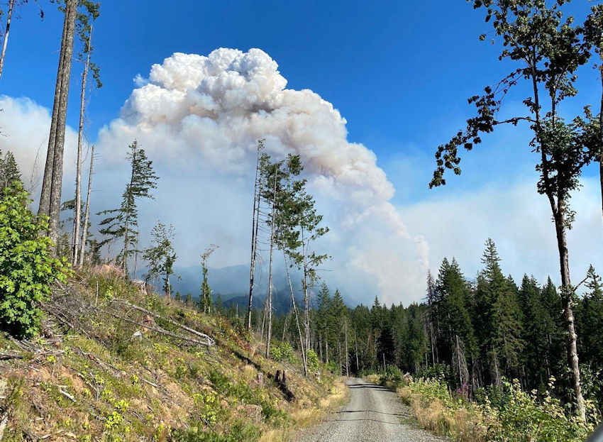
REDMOND, Ore. (KTVZ) -- Cooler weather helped firefighting efforts around the state Sunday, as crews increased containment on all three major fires in Central Oregon and also made progress on bigger fires elsewhere.
A local Central Oregon Fire Management Service Type 3 team has taken command of the Bean Creek and Monty fires burning on the Deschutes National Forest east of the Monty Campground, near Lake Billy Chinook.
More resources arrived on the two fires Sunday to add capacity to containment efforts. Crews mopped up heat around the perimeter to continue securing containment lines, and Sunday night, the Bean Creek Fire remained 138 acres and was 25% contained, while the Monty Fire remained 23 acres and was 20% contained.
A Level 1 evacuation notice (Get Ready) issued by Jefferson County Sheriff’s Officer remains in place for houses on Montgomery Shores on the Metolius Arm. The public is asked to stay out of the area. Monty Campground on the Sisters Ranger District remains closed.
The Hole in the Ground Fire on the south end of Deschutes National Forest, also burning on Lakeview District BLM managed lands, is now 100% contained, at 310 acres. The fire will now be put into patrol status.
Meanwhile, a wind shift cleared the smoky haze from much (but not all) of Central Oregon, as areas to the south still had "moderate" air quality levels at times Sunday. A big warmup due in the coming week will again test stretched-thin firefighting resources.
The most important thing members of the public can do to help firefighters right now is to do their part to prevent human-caused fires. With an increasing number of acres on fire in the Pacific Northwest, fire and aviation resources are stretched thin. The public is reminded that we remain in EXTREME fire danger and public use restrictions are in place on all federally managed public lands. Do your part to prevent one more spark.
For up-to-date information on Central Oregon fires, visit www.twitter.com/CentralORFire.
Here are Sunday updates on several of the largest fires and complexes - you can find a dashboard with details on the more than 100 fires across Oregon on KTVZ.COM's Fire Alert page.
Bootleg, Walrus, Yainax Fires Update Aug 8
Bootleg Fire Update, August 8, 2021
Location: 28 miles northeast of Klamath Falls, OR
Containment: 96%
Size: 413,765 acres (647 square miles)
Personnel: 1,125
Walrus Fire
Location: 10.5 miles N of Bonanza
Size: 75 acres
Containment: 0%
Yainax Fire
Location: 10 miles NE of Bonanza
Size: 88 acres
Containment: 0%
(Klamath Falls, OR) – Significant progress was made on the northeast corner of the Bootleg Fire yesterday and the official containment number grew to 96% due to hard-fought effort by firefighters for nearly a month. Engine crews will continue patrolling the fire perimeter as a safety measure for the foreseeable future. Crews and equipment will continue efforts to return the fireline to a more natural state, repairing the impacts on the landscape caused during the initial and extended attack periods of the fire. Smoke will be visible in the interior of the fire perimeter until a season ending event (heavy rains or snow). The fire size remains unchanged for the tenth consecutive day despite being tested by the hot, dry, windy days over the last week.
Ground resources on the Walrus and Yainax Fires, aided by heavy helicopters, kept fire growth to a minimum and completed hose lays around both fires. Containment lines are being constructed and reinforced and have a high probability of success in the coming shifts.
Calmer weather conditions today will aid firefighter in continued suppression and mop up efforts on both fires. Forest closure remains in effect, please check with your local ranger district before entering national forest lands.
Evacuations: Evacuations are dynamic. The best way to view the evacuation designation boundaries and details is on the interactive map available at tinyurl.com/bootlegevac
Closures: An emergency closure order is in effect for the Bootleg Fire on the Fremont-Winema National Forest to protect public and firefighter safety. All travel or entry into the area is prohibited. The full closure order and map are available on the website under Alerts and Closures at https://www.fs.usda.gov/alerts/fremont-winema/alerts-notices
Red Cross Evacuation Shelters: For information or assistance: 1-800-Red-Cross (www.redcrossblog.org/disaster)
Smoke: Wildland fire smoke can adversely impact your health. Be aware of the smoke near you and learn about ways to mitigate smoke impacts. See the air quality near you at https://fire.airnow.gov and learn how to keep smoke out of your home at https://www.epa.gov/smoke-ready-toolbox-wildfires
Insurance Assistance: For additional information on submitting insurance claims after losing your home or property to a wildfire, please visit https://dfr.oregon.gov/insure/home/storm/Pages/wildfires.aspx or call the state’s team of consumer advocates at 888-877-4894 (toll-free).
Fire Information Public Phone: 541-482-1331 Inciweb: inciweb.nwcg.gov/incident/7609/ Facebook: www.facebook.com/BootlegFireInfo Twitter: twitter.com/BootlegFireInfo Hashtags: #BootlegFire #FireYear2021
Middle Fork Complex Fire Update for 8/8/2021
Quick Facts:
Start Date: July 29th, 2021
Cause: Lightning
Incident Commander: Randy Johnson, PacificNorthwest Team 3
Location: Nine miles north of Oakridge, Middle Fork Ranger District, Willamette National Forest
Approx. Fire Size (acres): Gales: 2,969; Kwis: 358; Ninemile: 282; Elephant Rock: 7
Containment: 10%
Resources: Crews: 15; Engines: 17; Heavy Equipment: 12; Helicopters: 6; Water tenders: 11
Total Personnel: 591
Middle Fork Complex Fire Update – Sunday, August 8, 2021 – 9:00 a.m.
Community Fire Briefing at Greenwaters Park, 48362 Highway 58, in Oakridge - Monday, August 9 at 6:30 pm.
Yesterday: On the Kwis Fire, retardant and water were dropped to aid crews in controlling the spread of a spot fire south of the containment line. A smoke column was visible from the Gales Fire in the afternoon as fire activity increased. Crews and heavy equipment continued preparing existing road systems to be used as primary control lines around the Ninemile, Gales and Elephant Rock fires.
Today: Crews aided by aerial support will continue working to re-establish and secure containment line around the Kwis Fire. Hand crews and heavy equipment will continue preparing fire control lines on the Ninemile, Gales, and Elephant Rock Fires. For Gales Fire, the priority is to secure the northern and western edges of the fire perimeter. They are removing trees and undergrowth adjacent to existing roads and utilizing hand line and dozer lines where necessary to further establish fire control line intended to stop fire spread.
Management of the Knoll Fire, located on the McKenzie River Ranger District, will be transferred to Pacific Northwest Team 3 at 12pm today.
Of the 12 lightning-caused fires being managed as the Middle Fork Complex, eight were secured and have been patrolled in recent days with no additional fire growth observed. Actions taken to suppress these fires prevented them from spreading to adjacent communities and management of the Packard, Windfall, Symbol Rock, Devil’s Canyon, Larison Cove, Way, Warble, and Journey was transferred back to the Willamette National Forest yesterday.
Weather and Smoke: Cooler temperatures are expected today. Significantly warmer and drier conditions are anticipated starting Monday and lasting into the week. Overnight, steady west winds kept smoke from settling back into valley floors around the fire area and today air quality is expected to remain good overall for the Lane Deschutes forecast area. For current air quality information visit oakridgeair.org/smoke or the Oregon Smoke Blog https://oregonsmoke.blogspot.com/.
Evacuations: Effective July 30, 2021, all homes, campgrounds and dispersed recreation along Forest Service Road 18 (Big Fall Creek Road) east of the intersection with Forest Service Road 1821, including Puma Campground and Bedrock Campground, are at LEVEL 3 (GO NOW). More information, including a map of the evacuation area, can be found at www.lanecountyor.gov.
Closures: Some National Forest System lands near the Middle Fork Complex fires are temporarily closed to provide for public safety. Please be sure to check current conditions before planning your trip to the Willamette National Forest. For more information visit www.fs.usda.gov/willamette.
ADDITIONAL FIRE INFORMATION:
Fire Information: 541-625-0849
Facebook: www.facebook.com/MiddleForkComplex
Skyline Ridge Complex morning update for Sunday, Aug. 8, 2021
CANYONVILLE, Ore.—With a dozen smaller wildfires mostly trailed, mopped up or already in patrol status, more firefighters are engaged on preventing the spread of the Poole Creek Fire. Containment on the Complex has risen to 9 percent.
At 1,942 acres, Poole Creek is the largest fire in the Skyline Ridge Complex. It is burning roughly six miles southeast of the community of Days Creek. Firefighters plan to keep the fire within two steep drainages by building control lines on ridgetops and securing them with controlled burns at night. This will protect houses and outbuildings on the south bank of the South Umpqua River. Local residents can expect to see more fire traffic and smoke from burn-out operations.
Fire managers at the Complex are also responsible for identifying and helping suppress new fires in the area. Sunday afternoon they did just that. A pilot assigned to the Complex spotted a fire on the border of Douglas and Jackson counties, fire managers sent a 10-person hand crew to help Douglas Forest Protective Association firefighters engage the fire. The fire was kept to less than an acre. It likely started during last week’s heavy lightning strikes.
ODF Team 1 is hosting a virtual community meeting on Facebook Live Sunday at 7:30 p.m. You can find the event at https://www.facebook.com/events/540312997032963.
Incident Commander Joe Hessel said, “We’re protecting multiple values at risk including homes, communities, commercial timberlands, powerlines, recreation and cultural sites, and treasured fishing and hunting grounds. It drives our work to secure the last three active fires in the Complex as fast and as safely as we can.”
Information: https://inciweb.nwcg.gov/incident/7762/
---
Black Butte Fire Morning Update
Sunday, August 8, 2021 Fire: Black Butte Fire Containment: 0%Acres: 9,673 Start Date: August, 3, 2021Cause: Lightning Location: 8 miles NE of Antelope Lookout Total Personnel: N/A Fuels/Topography: Mixed brush, grasses, and timber
Type of resources: N/A
Today: Crews from Oregon Department of Forestry (ODF), Bureau of Land Management (BLM) and Forest Service will begin transitioning with the Northwest Incident Management Team 9, Type 2 team. More resources on the ground, including helping to secure the southern portion of the fire on and adjacent to private and BLM lands. The Infrared (IR) flight was done overnight, showing the acreage of the fire to be 9,673 acres.
Tomorrow: The Northwest Incident Management Team 9, Type 2 team will take over management of the fire at 0600, Monday, August 9
Ongoing fire activity in the Pacific Northwest is causing a limited amount of resources to be available. Each day, plans must be carefully evaluated for safety and resource protection.
Smoke: Fire management would like the public to be aware of potential smoke impacts from Black Butte Fire and others in the region. For more information regarding smoke please visit: Oregon Smoke Blog Spot, and Fire Air Now.
Closure area consists of all geographical areas within boundaries of the following description: Starting at the intersection of the Malheur National Forest Boundary and Forest Service Road (FSR) 14 and proceeding north on FSR 14 at T. 18 S, R. 34 E, Sec. 24, north to the junction with FSR 16 at T. 16 S, R. 35 E, Sec. 23, north on FSR 16 until County Road 62, at the junction with 62 go north on County Road 62 to FSR 6200918 at T. 14 S, R. 34 E, Sec. 30, to Sunshine Flat Trailhead, then east on Forest Service Trail (FST) 369 then at the junction of FST 363 and FST 369, head east on FST 363, then continue to the Horseshoe Trailhead at T. 14 S, R .35 E, Sec. 33, then south on FSR 13, at the junction of FSR 13 and FSR 16, east on FSR 16 to the Forest Boundary at T. 15 S, R. 36 E, Sec. 25, south along the Forest Boundary to T. 18 S, R. 36 E, Sec. 24, west along southern Forest Boundary to FSR 14 at T. 18 S, R. 34 E, Sec. 24. Boundary roads will remain open. ·
Recreation Sites within the closure boundary:
o North Fork Malheur River Trailheads both north and south
o North Fork Malheur Campground
o Crane Crossing Trailheads both east and west
o Short Creek Guard Station
o Elk Creek Campground
o Sunshine Flat Trailhead and Trail
o Horseshoe Trailhead and Trail
o Sheep Creek Trail and Trailhead
o Little Crane Campground
Currently the Trout Farm and Crescent Campgrounds are still open to the public.
Public Safety: Please be aware of the closure area and recreation sites closed within as noted above. There will be heavy fire traffic on all roads in the fire area, please use extra caution while driving in the vicinity. The public is reminded that the Malheur National Forest is under Phase C of Public Use Restrictions.
For more information on Public Use Restrictions please visit: Malheur Public Use Restrictions or call 541-575-3113.
Fire Information: Inciweb: https://inciweb.nwcg.gov/incident/7770/ Facebook: 2021 Black Butte Fire | Facebook and https://facebook.com/MalheurNationalForest/ Twitter: https://twitter.com/MalheurNF


