‘No new starts’: Welcome words while crews work to contain the region’s largest wildfires
(Update: Adding Green Butte Fire update)
Residents warned to be cautious; fire danger remains high
BEND, Ore. (KTVZ) -- A break in the extreme heat (which is set to return) and in the recent thunderstorms have allowed thousands of Northwest firefighters to build lines and containment figures on several large wildfires burning around the region, officials said in Saturday's updates.
Central Oregon Interagency Dispatch Update – August 6, 8:30 AM
Central Oregon – Yesterday was another quiet day across central Oregon for fire activity. There were no new starts.
Incident 558 has been named the Deadline Flat Fire. This fire is located on Prineville District BLM lands roughly 15 miles northwest of the town of Paulina. The fire remains 2 acres and crews made great progress mopping up hot spots yesterday. Three engines are assigned to the fire today and these resources will be working to secure control lines. Further updates regarding this fire will be shared on Twitter at @CentralORfire.
Weather conditions will be generally warm and dry, with low relative humidity across the area. Hot temperatures return to central Oregon Sunday and continue into next week. New starts will have the potential to spread rapidly under these conditions. Fuels like grass and brush are thick and dry right now, which means they are a very susceptible fuel source for wildfires.
As we move into another warming trend, fire officials would like to remind the public to exercise caution, as the potential for fire growth remains high. Check for fire restrictions before making plans to have a campfire. For more information on fire restrictions, visit: https://www.centraloregonfire.org/. If you do decide to enjoy a campfire in an approved fire ring at a designated campground, remember to drown, stir and feel before walking away. It should be cool enough to touch with your hand. Check your trailer chains to ensure they aren’t dragging; this can cause sparks. Avoid driving over or parking on dry vegetation.
Central Oregon may experience smoke impacts from a few different active fires on neighboring forests and surrounding states. Smoke often settles into low-lying areas and river corridors overnight. The public is advised to ensure all windows and doors are securely closed in the evening and early morning hours to limit smoke exposure. For air quality information, visit: https://fire.airnow.gov/ or https://www.airnow.gov/. For more information on how to limit your smoke exposure, visit: https://www.centraloregonfire.org/wildfire-smoke-your-health/.
This will be our last daily Central Oregon Interagency Dispatch Update for the time being until increased fire activity warrants additional updates. For current wildland fire information, the public can visit centraloregonfire.org or follow fire information on Twitter @CentralORfire.
Green Butte Fire Update – August 6, 2022, 12:30 p.m.
Central Oregon— The Green Butte Fire, located on the Bend-Fort Rock Ranger District on the Deschutes National Forest approximately 13 miles southeast of La Pine and approximately two miles northeast of Spring Butte, remains 23 acres and is now 50% contained.
Yesterday, firefighters made excellent progress and increased mop-up operations to 100 feet interior of the fire’s perimeter.
Today, firefighters are utilizing a UAS platform to detect hot spots within the fire area. The UAS platform measures temperatures and shows firefighters areas of increased heat. Crews can then focus their mop-up and gridding operations within these identified areas.
The public is reminded that “If You Fly, We Can’t.” While UAS technology is increasingly a tool utilized by firefighting resources, the public should never fly their personal drones over active wildfire incidents. Firefighters follow all applicable FAA standards and coordinate with local aircraft and dispatch.
For current wildland fire information, the public can visit centraloregonfire.org or follow fire information on Twitter @CentralORFire.
Cedar Creek Fire
August 6, 2022
Daily Update – 8:00 AM
Acreage: 1,438
Containment: 0%
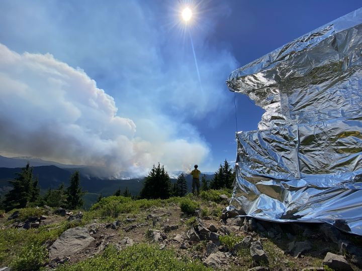
Highlights: Pacific Northwest Team 2, a Type 1 Incident Management Team, assumed command of the Cedar Creek Fire on August 5, 2022, at 8:00 p.m. The fire did not grow much in the last 24 hours. Firefighters worked along Forest Road (FR) 2422 and FR 2417 on Friday to improve access to the fire area. The historic Waldo Lookout was wrapped with protective foil to protect it in the event the fire was to threaten the lookout. Helicopters were used on Friday to keep the fire in check.
Operations: Engines will continue to improve access along FR 2422 and FR 2417 and dozers will be used to clear out vegetation. As additional firefighters arrive on scene, they will continue to develop plans to engage the fire in areas with the highest probability of success while maintaining firefighter and public safety. Four Type 1 and one Type 3 helicopters are available to support firefighters on the ground as conditions allow. The IMT will have responsibility for initial attack of any new fires within the Temporary Flight Restriction (TFR).
Evacuations: None
Weather: Temperatures are expected to be in the mid-80s. Winds will be light and breezy throughout the day.
Closures: The entire Waldo Lake Wilderness area is closed due to the Cedar Creek Fire. This includes all trailheads and dispersed camping west and north of Waldo Lake. The lake itself remains open as well as campgrounds on the east side. A Temporary Flight Restriction (TFR) is in place in ten mile radius around the fire.
Restrictions: Fire restrictions are in place on the Willamette National Forest with the exception of the Three Sisters, Mt. Jefferson, Mt. Washington, Waldo Lake, and Diamond Peak Wilderness areas. All campfires, charcoal or briquette fires, pellet fires, or any other fires will be prohibited, except in designated campgrounds. Portable cooking stoves, lanterns and heaters using liquefied or bottled fuel are still allowed if they can be switched on and off. Motorized vehicles may operate only on designated trails and roads, including within the Huckleberry Flats and Santiam Pass OHV areas.
Smoke: Smoke Forecast Outlooks (in both English and Spanish) are available at https://outlooks.wildlandfiresmoke.net/outlook. Air quality in Oakridge is expected to be good, with the best time of day to recreate outdoors being late afternoon.
Fire Information: Office Hours: 8:00 AM – 8:00 PM | Phone: 541-201-2335 | Email: 2022.cedarcreek@firenet.gov | Online: https://inciweb.nwcg.gov/incident/8307/ | https://www.facebook.com/CedarCreekFire2022/ | https://www.facebook.com/willamettenf | https://twitter.com/willametteNF
Miller Road Fire Update
Saturday, August 6, 2022 9:00 a.m.
NWIMT 8 Ed Hiatt, IC
OSFM Blue Team Scott Magers, IC
Miller Road Fire Information: (503) 383-9278 (8am - 6pm)
Email: osfm.fireinformation@gmail.com
Facebook: https://www.facebook.com/OfficialMillerRoadFire
Estimated Size: 11,156 acres
Containment: 42%
Start Date/Time: 8/2/2022
Location: Juniper Flat, Wasco County
Cause: Under investeigation
Assigned: 420 personnel, 38 engines, 2 dozers, 10 water tenders
5 Structure Task Forces
Single Residences Threatened: 881
Minor Structures Threatened: 216
Structures Damaged: Under Assessment
Structures Destroyed: 1
Wasco County, OR – Great work has been completed in the past two
days on the Miller Road Fire. Containment has increased to 42%. Cooler
temperatures and lower wind speeds have supported the firefighters’
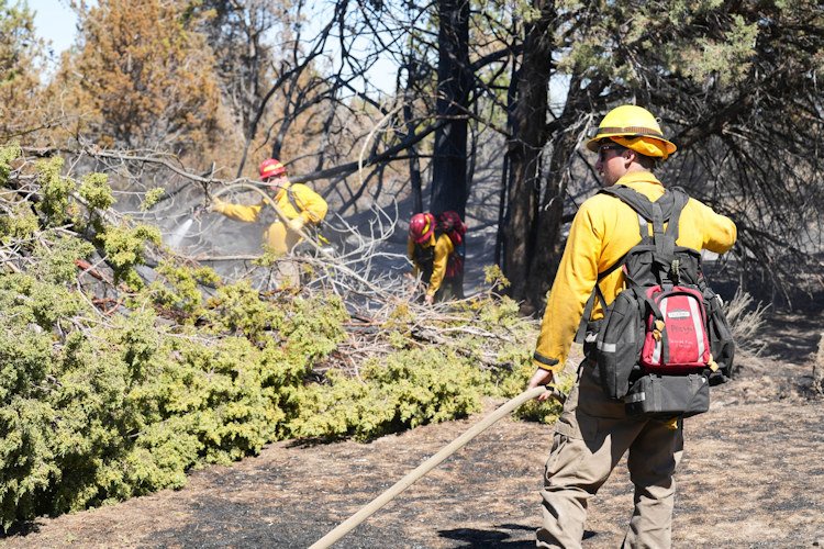
search for hot spots. Hand crews continued mop-up on the line and
thermal imaging cameras (TIC) were used to help identify fuels retaining
heat.
Two Task Forces worked throughout the night mopping up the line on
the south side of the fire and around structures on the north side.
Today, Northwest Incident Management Team 8 (NWIMT8) will
continue mop-up operations around the perimeter of the fire working
toward the goal of 100% containment. OSFM Task Forces will focus on
mop-up around structures.
Oregon State Fire Marshal Task Forces will be wrapping up their work
and headed back to their home agencies over the next two days. As of
today, 5 Task Forces will be on the line working. Structure firefighters
and OSFM Blue Team will be demobilized Sunday.
Southern Wasco County could reach 100-degree temperatures today.
Winds are expected to be light in the morning with a wind shift
happening in the afternoon.
Evacuation orders remain in place but levels have decreased. All areas
that were a level 3 are now a level 2, and all areas that were a level 2 are
now a level 1. The latest evacuation information can be found by visiting
www.facebook.com/WascoCountySheriff.
Saturday morning update:
Evacuation Level for Maupin, Tygh Valley and Oak Springs Road have been lifted. Level 1From Victor Rd and Walters Rd North and South side of 216 to Hwy 197 has now been dropped to Level 1 Get Ready.
The evacuation shelter at Dufur High School has closed. All roads
throughout the area remained open to the public.
Windigo and Potter Fires Update – August 06, 2022
For firefighter and public safety, two closure orders were finalized for areas overlapping the Umpqua, Deschutes, Willamette, and Fremont-Winema National Forests. For details about the Windigo Fire and Potter Fire closures visit: https://go.usa.gov/xSGhh.
Yesterday, fire growth was minimal for the Windigo and Potter Fires. Crews worked on an additional start that was located near the Big Swamp Fire. It is .2 acres. After an infrared flight, Big Swamp Fire is estimated to be 37 acres. Mop-up continued on the Shelter Fire. It remains under 5 acres and is fully lined with water hoses. Today, resources will continue to support suppression efforts on all fires.
Yesterday, air attack worked aggressively on the Windigo Fire with consecutive retardant drops on Windigo Butte and multiple water bucket drops throughout the perimeter. Handcrews continued to create line up the butte and dozers made progress on the western half. The fire is expected to be fully lined over the course of the next few days and crews will continue to add fire hose.
The Potter Fire continued to advance downslope. Today, all divisions will strengthen primary lines and scout for opportunities to go more direct. Air resources for both fires will include five Type 1 Helicopters and one Type 3, with one additional Type 1 in route.
Today, weather will be moderate. High temperatures may reach 83-87 degrees. West/northwest winds will be between 3-6 mph with gusts of up to 15 mph on ridge tops and valleys. Fire spotting distances may be up to ¼ - ½ mile. For information about air quality visit https://fire.airnow.gov/.
Windigo Fire
Acreage: Approx. 1,046 acres
Containment: 5%
Location: 20 miles southwest of La Pine, OR
Cause: Lightning
Potter Fire
Acreage: Approx. 167 acres
Containment: 0%
Location: 8 miles northeast of Toketee Lake
Cause: Lightning
Area closures and restrictions include:
● Pacific Crest Trail from OR Highway 138 (PCT mile 1848) to OR Highway 58 (PCT mile 1908)
● Forest Service Road (FSR) 60 from the junction with FSR 6020 to FSR 2612
● Forest Service Road (FSR) 2610 from Lemolo Dam to Calapooya Mountain
● Kelsey Horse Camp on the Umpqua and White Fish Horse Camp on the Deschutes
● Toketee Air Strip
● The Temporary Flight Restriction now covers 151,963 acres
Fire Information Phone Line: 206-473-8645 (8am - 7pm)
Email: 2022.Windigo@firenet.gov
Potter Fire InciWeb (Incident Website): https://inciweb.nwcg.gov/incident/8291/
Windigo Fire InciWeb (Incident Website): https://inciweb.nwcg.gov/incident/8292/
Facebook: https://www.facebook.com/Windigo-Fire-and-Potter-Fire-Information-109233838550715
U.S. Forest Service-Deschutes National Forest
U.S. Forest Service - Umpqua National Forest
U.S. Forest Service - Willamette National Forest
#WindigoFire #PotterFire #ShelterFire #bigswampfire
Beech Creek Fire Update – August 6, 2022
JOHN DAY, PRAIRIE CITY, and HINES, OR – (Saturday, August 6, 2022) Firefighters are taking advantage of favorable weather conditions to increase containment on the Beech Creek Fire. Updated mapping puts the fire at 155 acres with 45% containment. The fire started on the afternoon of August 1st and is located nine miles south of Long Creek. There are no evacuations in place.
On the northern portion of the fire, fire crews are mopping up to increase the depth of containment lines and continue to mitigate hazard trees along Highway 395. All spot fires are fully lined and mopped up. Equipment and falling modules made good progress on direct containment lines on the southern portion of the fire yesterday. Hazard trees are being removed to allow firefighters to safely enter and work in the area to suppress the fire. The contingency line south of the direct primary dozer line is prepared if needed.
Travelers in the area may see smoke as interior pockets of unburned fuel are consumed in the fire. Check road conditions prior to traveling in the area for information on delays or closures. The public can monitor smoke and air quality across the state by visiting: http://oregonsmoke.blogspot.com.
The High Desert Type 3 Incident Management Team and Malheur National Forest would like to thank the communities for their support during the duration of this complex incident. Fire updates are aired on KJDY and are posted at Chester’s Market, the DinoMart in John Day, and the Chevron station in Mt. Vernon. For more information and all the latest forest news on the Malheur National Forest, please visit our website at www.fs.usda.gov/malheur, follow U.S. Forest Service-Malheur National Forest on Facebook, and follow @MalheurNF on Twitter.
NW Interagency Coordination Center large fire summary map:
