Cedar Creek Fire near Waldo Lake tops 1,800 acres, still zero containment; more progress on other blazes
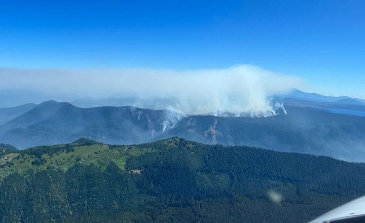
BEND, Ore. (KTVZ) -- While firefighters continued making progress Sunday on several mostly lightning-sparked wildfires around the region, officials on the still-growing Cedar Creek Fire near Waldo Lake are still trying to determine the best way to access and contain the hard-to-reach blaze.
Smoke jumpers responded Sunday evening to a small new fire, Incident 569, on the Deschutes National Forest near Lily Lake, northeast of Waldo Lake. Air resources from the nearby Cedar Creek Fire were providing water drops on the fire, estimated at 1/10th of an acre by air attack, officials said.
As of Sunday morning, there were 11 active large wildfires in the Northwest, seven in Oregon and four in Washington, according to the Northwest Interagency Coordination Center.
Green Butte Fire Update – August 7, 2022, 9:00 a.m.
Central Oregon— The Green Butte Fire, located on the Bend-Fort Rock Ranger District on the Deschutes National Forest approximately 13 miles southeast of La Pine and approximately two miles northeast of Spring Butte, remains 23 acres and is now 80% contained.
Yesterday, firefighters continued mop-up operations using a UAS platform to detect hot spots within the fire area. Utilizing UAS heat sensing technology provides an additional tool to firefighters on the ground without the risk and cost associated with flying traditional aircraft.
The public is reminded that “If You Fly, We Can’t.” The public should never fly personal drones over active wildfire incidents. Firefighters follow all applicable FAA standards and coordinate with local aircraft and dispatch.
Today at 7 a.m. the Type 3 Incident Management Team transitioned command of the Green Butte Fire back to the Bend-Fort Rock Ranger District and a Type 4 incident commander. Once full containment is reached, the district will continue to monitor the area in the coming days.
This will be the final update for the Green Butte Fire.
Elsewhere, the Deadline Flat Fire on the BLM's Prineville District, about 15 miles northwest of Paulina, was fully contained at two acres.
For current wildland fire information, the public can visit centraloregonfire.org or follow fire information on Twitter @CentralORFire.
Here's Sunday's updates on some of the larger Oregon fires:
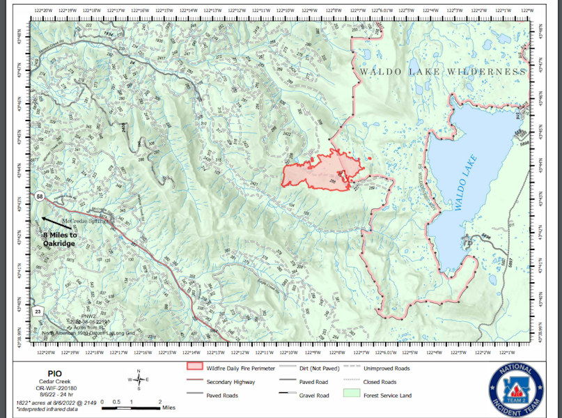
Cedar Creek Fire
August 7, 2022
Daily Update – 8:00 AM
Acres: 1,822 | Contained: 0% | Total personnel: 194 |Start Date: August 1, 2022| Cause: Lightning |
Location: 15 miles E of Oakridge, OR | Fuels: Heavy mixed conifer, ponderosa pine, brush, and grass
There will be a virtual public meeting at 7:30 p.m. on Monday, August 8 on Facebook
https://www.facebook.com/CedarCreekFire2022/
Highlights: During yesterday’s shift, firefighters continued to scout for opportunities to safely engage
the fire. Crews continue to assess roads and trails in the area of the current fire perimeter that could be
used as part of a containment strategy to minimize the fire area while also provide for firefighter safety.
If conditions change rapidly and crews need to quickly withdraw, firefighters need to have a clear and
safe escape route.
Fire managers have identified Black Creek Road as a possible containment line on the
southern fire perimeter that will be used if a more direct attack strategy cannot be safely implemented.
Operations: Increased temperatures are predicted on the fire today, which could lead to more active
fire behavior.
The fire is expected to continue to move to the northeast and southeast into the Waldo
Lake Wilderness. Fire managers are finalizing a containment strategy and additional crews will soon be
brought in to assist in suppression efforts. Multiple air resources are available today to assist in
moderating fire behavior if fire activity increases.
Evacuations: Currently there are no evacuations in place.
Weather: A continued hot, dry weather pattern is forecasted through Sunday with temperatures in the
mid-to-upper 80s and winds sustained 4-8 mph, gusting to 15 mph.
Closures: The entire Waldo Lake Wilderness area is closed due to the Cedar Creek Fire. This includes all
trailheads and dispersed camping west and north of Waldo Lake. The lake itself remains open as well as
campgrounds on the east side. A Temporary Flight Restriction (TFR) is in place in a ten-mile radius
around the fire.
Restrictions: Fire restrictions are in place on the Willamette National Forest with the exception of the
Three Sisters, Mt. Jefferson, Mt. Washington, Waldo Lake, and Diamond Peak Wilderness areas. All
campfires, charcoal or briquette fires, pellet fires, or any other fires will be prohibited, except in
designated campgrounds. Portable cooking stoves, lanterns and heaters using liquefied or bottled fuel
are still allowed if they can be switched on and off. Motorized vehicles may operate only on designated
trails and roads, including within the Huckleberry Flats and Santiam Pass OHV areas.
Smoke: Smoke Forecast Outlooks (in both English and Spanish) are available at
https://outlooks.wildlandfiresmoke.net/outlook. Air quality in Oakridge, Oregon is expected to be good
with the best time of day to recreate outdoors being late afternoon.
Fire Information: Office Hours: 8:00 AM – 8:00 PM | Phone: 541-201-2335 | Email:
2022.cedarcreek@firenet.gov | Online: https://inciweb.nwcg.gov/incident/8307/ |
https://www.facebook.com/CedarCreekFire2022/ | https://www.facebook.com/willamettenf |
https://twitter.com/willametteNF
---
Miller Road Fire Update
Sunday, August 7, 2022
9:00 a.m.
Estimated Size: 10,847 acres (adjusted down from 11,156)
Containment: 95%
Start Date/Time: 8/2/2022
Location: Juniper Flat, Wasco County
Cause: Under Investigation
Assigned Resources: 251
Engines: 9
Dozers: 1
Water Tenders: 6
Air Assets: As Needed
Structure Task Forces: 1 engine
Structures Damaged: Under Assessment
Structures Destroyed: 1
Closures: None
Wasco County, OR – This will be the last update from the Miller Road Fire. We would all like to take this opportunity to say "thank you" to the communities, cooperators, agency staff, and firefighters for the unwavering support.
Significant work on the Miller Road Fire has been done by firefighters from the rural fire districts, Oregon State Fire Marshall (OSFM), and Northwest Incident Management Team 8 (NWIMT8). Containment of the fire is now at 95%. Hand crews have been focusing on mop-up operations along the 25 miles of the fire’s perimeter and around structures with the goal of establishing a cold black containment line preventing any lingering interior fire from escaping.
OSFM Task Forces and other resources will be progressively demobing back to their home agencies. NWIMT8, which is currently managing the fire, will also begin demobing resources on Monday as the need for fire personnel decreases. A smaller incident management organization will remain on the fire comprised of 2 hand crews and engines patrolling the fire and continuing mop-up. Firefighters will remain vigilant on the fire line as the weather is predicted to become hotter and drier for the next couple of days.
The fire information email, phone number and Facebook page (OfficialMillerRoadFire) will be closed as of August 7 at 7 PM. Future information distribution for the Miller Road Fire will be provided by the Central Oregon Fire Information Duty Officer.
· 541-316-7711 Fire Information
· centralorfireinfo@gmail.com · www.centraloregonfire.org
· Twitter @CentralORfire
Evacuation orders remain in place but levels have decreased. The latest evacuation information can be found by visiting www.facebook.com/WascoCountySheriff. All roads throughout the area remain open to the public.
Windigo-Potter-Big Swamp-Shelter Fires Update – August 07, 2022
Containment on the Windigo Fire increased to 15% as firefighters continued to make progress on all fires in the area. The incident command team is currently managing 237 sq. miles across the Umpqua, Willamette, Deschutes, and Fremont-Winema National Forests—which includes 27 known fires. Eight have active fire behavior. All 27 fires have resources assigned. Weather will challenge suppression efforts over the next few days as crews battle higher temperatures and dryer fuels. For firefighter and public safety, follow the Fire Closure Orders http://go.usa.gov/xSGhh.
Yesterday, crews and heavy equipment successfully dug line around the entire perimeters of the Windigo and Potter Fires. Today, ground resources will continue to plumb, mop-up, hold and secure the fire line of the Windigo Fire. Firefighters on the Potter Fire will continue to develop and strengthen alternate and contingency lines. Air resources will support Initial Attack if any spot fires occur outside of the fire perimeters. Today, they will include eight Type 1 Helicopters and one Type 3, with 2 fixed-wing scoopers available out of Eugene.
The Big Swamp Fire grew an estimated 10-15 acres. Three handcrews, 2 engines, and multiple pieces of heavy equipment will be working on that fire today with more resources en route. The small fire near Big Swamp, named 210, is still .2 acres. Shelter Fire is still under 5 acres and is secure. An additional start began south of Potter Mountain, named 212, and is .5 acres. Crews will continue to secure fire line and search for remaining pockets of heat on the smaller fires.
Today’s weather changes are expected to increase fire behavior. High temperatures will reach 86-92 degrees. Wind direction will change midday and flow from a NW direction with speeds between 5-8 mph and gusts of up to 15 mph on ridge tops and valleys. Fire spotting distances may be up to ¼ - ½ mile with a 90% chance of ignition on the dry fuels. Smoke will be more visible today as unburned islands of green fuel burn within the interior of the fire perimeters; visit AirNow.gov for more information.
Help keep our firefighters and yourself safe by obeying the forest closures, avoiding the entire restricted area. A large closure area is necessary to ensure that firefighters can focus on managing the fire, not evacuating visitors, should conditions on the fire change rapidly. http://go.usa.gov/xSGhh
Windigo Fire
Acreage: Approx. 1,052 acres
Containment: 15%
Location: 20 miles southwest of La Pine, OR
Cause: Lightning
Potter Fire
Acreage: Approx. 185 acres
Containment: 0%
Location: 8 miles northeast of Toketee Lake
Cause: Lightning
Closures: For firefighter and public safety follow the Windigo and Potter Closure Orders. http://go.usa.gov/xSGhh
Fire Information Phone Line: 206-473-8645 (8am - 7pm)
Email: 2022.Windigo@firenet.gov
Potter Fire (& Shelter) InciWeb: https://inciweb.nwcg.gov/incident/8291/
Windigo Fire (& Big Swamp) InciWeb: https://inciweb.nwcg.gov/incident/8292/
Facebook: https://www.facebook.com/Windigo-Fire-and-Potter-Fire-Information-109233838550715
U.S. Forest Service-Deschutes National Forest
U.S. Forest Service - Umpqua National Forest
U.S. Forest Service - Willamette National Forest
WindigoFire #PotterFire #BigSwampFire #shelterfire
---
Beech Creek Fire Update – August 7, 2022
JOHN DAY, PRAIRIE CITY, and HINES, OR – (Sunday, August 7, 2022) Containment has increased to 66% on the 155-acre Beech Creek Fire. A few days of cooler temperatures and higher humidity recoveries at night have aided firefighter progress in anticipation of the dryer and warmer conditions expected Sunday through Thursday. Personnel are continuing to support both day and night suppression operations.
Fire suppression efforts are now concentrated on strengthening containment lines south of Hwy 395. Heavy equipment, such as feller bunchers, are working to mitigate hazard trees to allow fire crews safer access to secure the direct dozer lines. The unpredictability of fire-weakened trees poses a considerable risk to firefighter safety, so heavy equipment operators and felling teams are brought in to help mitigate those hazards. Resources along the northern section of the fire perimeter continue to reinforce and patrol containment lines having successfully mopped up, or extinguished pockets of heat, 300 feet interior from the fire’s edge.
Those traveling along Hwy 395 between Long Creek and Mt. Vernon can expect some delays as fire personnel continue to work along the roadway. Flaggers and a pilot car are leading traffic through the fire area. For updated information on delays or road closures prior to traveling in the area please visit: https://www.tripcheck.com. Smoke and air quality impacts within the state can be monitored by visiting: http://oregonsmoke.blogspot.com.
Fire updates are aired on KJDY and are posted at Chester’s Market, the DinoMart in John Day, and the Chevron station in Mt. Vernon.
As temperatures warm up again, the public are encouraged to be aware of the elevated fire danger on the Malheur National Forest. Current fire conditions and public use restrictions can be found on the Forest webpage: https://www.fs.usda.gov/malheur.
For additional fire information, please visit: Inciweb: https://inciweb.nwcg.gov/incident/8301
Facebook: https://www.facebook.com/MalheurNationalForest
Twitter: https://twitter.com/MalheurNF
Email: 2022.beechcreek@firenet.gov
