Fifteen new C.O. fires reported Wednesday in wake of latest lightning; largest grows to 120 acres
(Update: 15 new fires, most kept small; Post-Paulina-area fire grows to 120 acres)
REDMOND, Ore. (KTVZ) -- Fifteen new fires were reported Wednesday to the Central Oregon Interagency Dispatch Center, and crews again were able to keep most small, at less than a quarter-acre, but a couple grew larger, one to 120 acres.
The two fires pushed crews Wednesday afternoon, but with the support of aircraft, forward progress of the fires was stopped, officials said.
The Sheep Rock Fire was reported late Wednesday afternoon north of Prineville, on private lands protected by the Oregon Department of Forestry, and at last report was about six acres.
Large air tankers and single-engine air tankers were able to slow the fire spread, allowing dozers to work on establishing fireline and firefighters to cool the fire edge. Firefighters were still on scene Wednesday evening, building line and securing the fire.
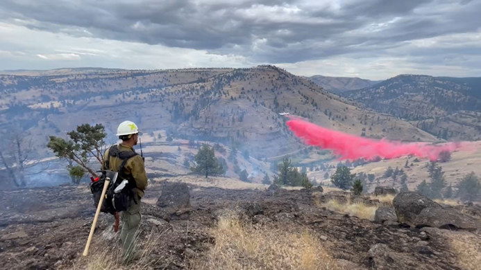
Incident 674 was estimated to be 120 acres, burning on private lands within the Post-Paulina Rangeland Fire Protection Association. Resources were continuing to work with rangeland association members to establish fire lines.
Acreage for the Doghouse Gulch Fire, located near the South Fork of the John Day River drainage, was updated overnight to 57 acres. Firefighters expect to continue work strengthening fireline and clearing fuel and heat adjacent to the perimeter for the next few days.
And more fires are expected Thursday, as warm weather continues to dry wildland fuels. These holdover fires can create significant challenges for firefighters when they begin to burn more intensely after building up heat smoldering in damp fuels. Detection is a challenge, as smoke dissipates without a defined column while creeping around.
Firefighters also were busy mopping up and strengthening the lines on some of the over 100 fires reported Tuesday from more than 1,000 lightning strikes in the area.
New blazes continue to emerge. One reported early Wednesday afternoon northwest of Redmond, near NW 83rd Street and Yucca Avenue, moved slowly in sagebrush and juniper, with Central Oregon Interagency Dispatch providing mutual aid and two Cloverdale Fire engines reportedly called up.
Redmond Fire Marshal Tom Mooney said it appeared to be started by a tree struck by Tuesday night's lightning and was stopped about an acre, with no structures damaged or threatened. Oregon Department of Forestry units took over from Redmond units, he said.
Other new starts were reported Wednesday afternoon, the largest Incident 704 north of the Foley Butte area, estimated to be 2-plus acres.
Meanwhile, Oregon Highway 140 between Lakeview and Adel reopened Wednesday following a Tuesday mudslide, officials said.
Despite abundant rainfall in places, there’s still a “high potential” for holdover or “sleeper” fires for the next few days, Fire Information Officer Christie Shaw said.
The Oregon Department of Forestry gave this wrap-up Wednesday of Central Oregon fires on state-protected lands:
Lightning Starts Numerous Fires on ODF Protection in Central Oregon District
[Prineville, Ore.] Thunderstorms swept through the Central Oregon District Tuesday, igniting 15 fires on Oregon Department of Forestry protection, with the largest fire being ¼ acre. Significant rainfall accompanied these storms helping to reduce fire behavior.
Additional fire detections from these storms are anticipated as vegetation and fuels dry with warmer, seasonable temperatures and increasing winds. These holdover fires can creep around smoldering in wet fuels and vegetation for days or weeks until conditions are right for them to spread rapidly.
The Central Oregon District is using a variety of methods across the landscape to detect fires at a small size. Reconnaissance flights with observers are being used across the district with federal partners as well as the Hood River County Sheriff’s Office today, looking for fire and smoke from new wildfire starts.
Last night ODF, used their multi-mission platform equipped with infrared and thermal detection capabilities to fly portions of the district. They turned in twenty detections across the flight area and will be back in the air tonight if conditions cooperate.
Typical detection methods are also being used, such as manned fire lookout towers and firefighters scouting with maps of the lightning locations. In some areas detection cameras are being used to find new fires and gather intel for responding firefighters.
“Yesterday’s lightning storms were impressive and had me concerned,” said Rob Pentzer, District Forester for the Central Oregon District. “But our firefighters along with our landowners and partners put in great effort to keep these fires small. And because of that we’re in good shape today as we continue to respond to new fires.”
Early August is often considered the peak of fire season in Oregon, with cured wildland fuels, hot temperatures, and lightning. This round of thunderstorms will continue to push firefighters, but so far this year their hard work has resulted in successfully reducing impacts from wildland fires to natural resources, public health, landowners, and communities in the Central Oregon District.
Year-to-date there have been 19 lightning fires on ODF protection in the district, burning 108 acres and 25 human starts, burning 23 acres. The 10-year average for lightning fires is 41 fires, burning 2,646 acres and 49 human caused fires burning 2,082 acres.
Firefighters across the District have been engaged in long hours of arduous work to keep these fires small. A strike team of five engines from ODF districts in northwest Oregon arrived in Prineville today to provide additional capacity for initial attack resources on new starts. ODF resources will continue to patrol looking for new starts and working with partner agencies to secure fires on the landscape.
For additional information on ODF’s Central Oregon District, including contact information and unit offices, please visit www.ODFcentraloregon.com.
Earlier story:
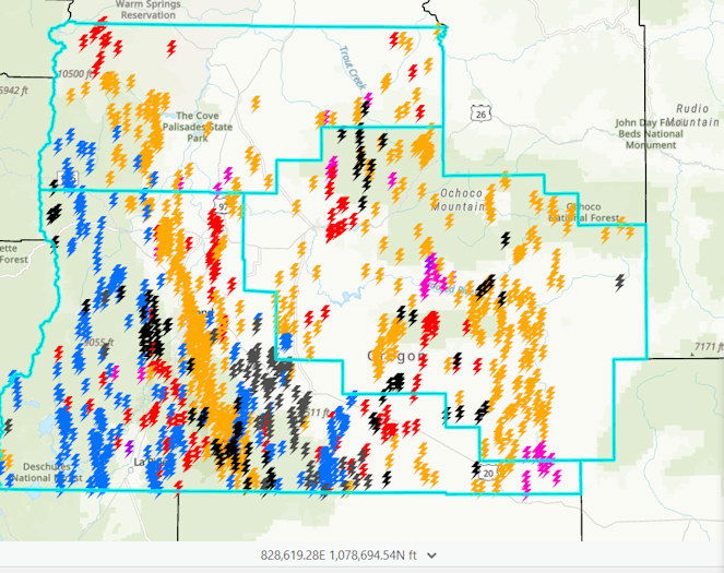
Intense thunderstorms rumbled through Central Oregon Tuesday afternoon, hitting the region with hundreds of lightning strikes that had fire crews from numerous agencies scrambling to catch dozens of fires ignited around the area, stopping most at small sizes.
In its 8 p.m. Tuesday update, the Central Oregon Interagency Dispatch Center said the tri-county area (Crook, Deschutes, and Jefferson counties) of Central Oregon received over 1,000 lightning strikes in the past 48 hours.
Over 100 fires were reported to COIDC Tuesday, with more coming in every hour. Most of the fires are staffed with firefighters and fires are reported at less than a quarter-acre in size. Firefighters continue to work their way in to some of the more remote fires and are working to locate some of the reported fires.
The Doghouse Gulch Fire, located near the South Fork of the John Day River drainage, was the largest of the fires reported Tuesday, estimated at 16 acres. Single-engine air tankers and helicopters are being used to slow the fire, allowing ground resources to engage directly.
Meanwhile, smokejumpers are working a cluster of fires near Cultus Lake, all of which are estimated to be less than a quarter of an acre or single-tree fires. They will continue to build fireline and mop-up these incidents until the work is completed.
As vegetation dries out over the next few days and seasonable warm weather returns, more holdover fires are expected. These fires are initially dampened by the rain that comes with the thunderstorms and creep around smoldering until growing large enough to be detected.
To reduce the potential of these fires becoming large fires before they are reported, daily flights will be conducted, with observers looking for smoke and fires. In addition to these “recon” flights, thermal and infrared technology will be used at night, as conditions allow, to detect heat and fire from specialty detection aircraft.
Early detection of wildfires results in less damage to natural resources, less smoke impacts to public health, and less damage to personal property and life, COIDC said.
In Central Oregon the Deschutes and Ochoco national forests, Crooked River National Grassland, Bureau of Land Management Prineville District and Oregon Department of Forestry work cooperatively to detect and respond to wildfires across the landscape.
Manned lookouts, smoke detection cameras, thermal/infrared technology, and recon flights are all used to detect fires at the smallest possible size.
Additionally, firefighters use maps of lightning strikes to patrol and look for fires. This coordinated response of resources and detection assets allows firefighters to focus on fire suppression activities across all ownerships.
The National Weather Service issued a Red Flag (fire weather) Warning that was in effect until 9 p.m. Tuesday.
The NWS in Pendleton also issued a special weather statement around 12:40 p.m., warning of a string of strong thunderstorms extending from east of Sunriver to east of Millican, moving north at 50 mph and packing winds gusting to 55 mph. Forecasters also reported another strong thunderstorm around 1:1 5p.m. near Tumalo, quickly moving north.
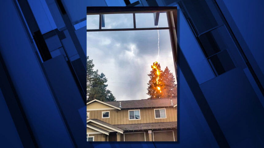
Jakki Carter, who works remotely from her home on Britta Street in northwest Bend, saw some flashes of lightning outside her home office window and caught on camera one strike that ignited a fire down a tall tree nearby.
It was one of many trees struck by lightning bolts around the region Tuesday afternoon as fire crews rushed to put them out. Some buildings apparently were hit as well.
Due to heavy rain, police said the Greenwood Avenue and Third Street underpasses were flooding and urged motorists to avoid the areas for a time.
About 500 Pacific Power customers were without service at mid-afternoon, down to only about a dozen by evening.
Other utilities reported outages as well. Redmond-based Central Electric Cooperative had members affected in the Tumalo area, southeast Bend and the Marks Creek/Ochoco Ranger Station area. About 480 members were affected, said Brent ten Pas, CEC's director of member and public relations. About 60 were without power Tuesday evening, according to an outage map.
In southern Deschutes County, Midstate Electric Cooperative reported outages Tuesday evening from La Pine to the north, east and west. An outage map showed some 750 members without service.
The utility urged people to not approached downed lines or debris in the lines, and instead keep a safe distance and call 800-752-5935 to report an outage, debris on a line or other issues.
The heavy rain also brought mudslides in southeast Oregon that closed a 13-mile stretch of state Highway 140 between Lakeview and Adel late Tuesday.
ODOT said a detour was established on Plush Cutoff Road, but this road is not accessible to over-dimensional loads. The detour is well signed and staffed, they said, and will be in place through the night. Crews are working to clear the highway; ODOT urged drivers to use caution and expect delays.
It had already been a busy day, with more than a dozen smoke reports checked earlier by Central Oregon fire crews around the region.
After a stormy, lightning-filled night in the Bend area, a lightning strike on a transmission line east of town Tuesday morning knocked out power to about 34,000 Pacific Power customers for up to almost two hours.
The outage began around 6:45 a.m., when lightning hit a transmission line by U.S. Highway 20 at Ward Road, utility spokesman Drew Hanson said.
At its height, 34,000 customers were without service, Hanson said, but “crews got to work right away” and restored power to about half of those affected within a half-hour. All were restored by about 8:30 a.m., although the outage map showed a few small scattered lingering outages affecting only about a dozen customers.
