Rum Creek Fire grows to 8,400 acres, destroys 3 structures; Gov. Brown declares state wildfire threat emergency
(Update: Fire Marshal calls up Oregon task forces to Rum Creek Fire; Calif. also sending crews)
Remote area remains under evacuation; sections of Rogue River closed to boaters
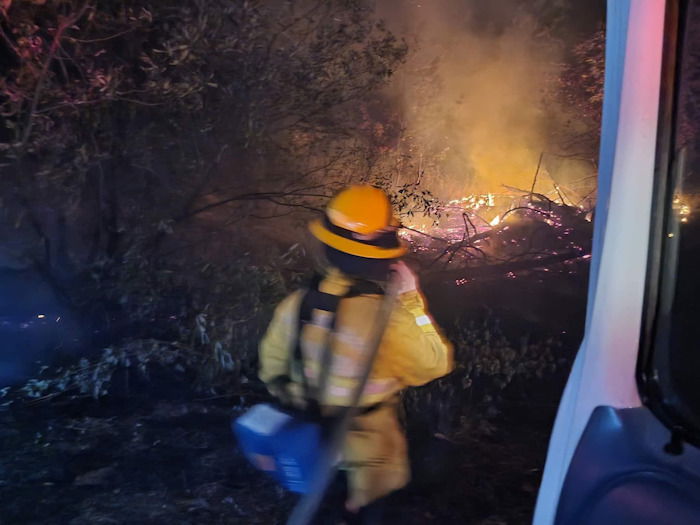
MERLIN, Ore. (AP) — A wildfire in remote southwest Oregon continued its rapid spread through a rural area and destroyed several structures after forcing evacuations and prompting the state to take command of efforts to contain the blaze, officials said Sunday as Gov. Kate Brown declared a statewide emergency due to the imminent threat of more blazes.
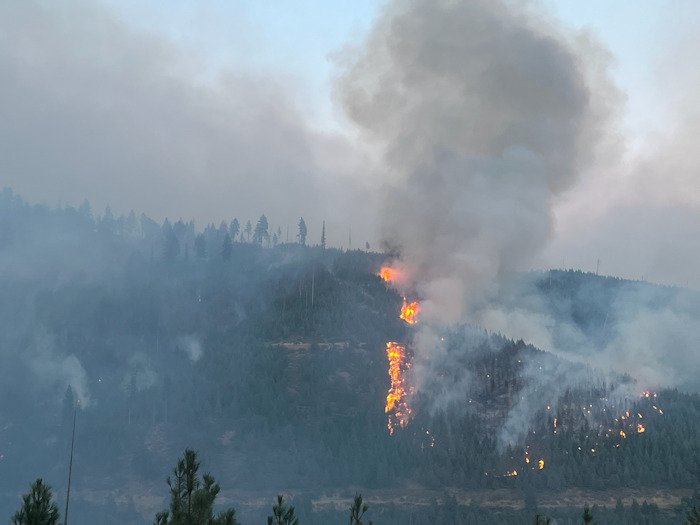
The Rum Creek Fire has burned more than 8,400 acres, or almost 15 square miles (38 square kilometers), according to the National Interagency Fire Center. That's more than double the 7 square miles (19 square kilometers) reported Saturday.
A house and two mining structures were destroyed, fire spokesperson Scott Owen said. A heat wave moving into the area in coming days could worsen the situation and make it easier for fuels to burn, officials said.
A remote area with about 200 people and more than 100 houses and other structures remained under evacuation, according to information from Josephine County Emergency Management.
The evacuation included the unincorporated community of Galice. Sections of the Rogue River, which is popular among rafters and fishers, were closed to recreation because of the fire.
Gov. Kate Brown’s office on Saturday announced she had invoked an emergency act that cleared the way for the State Fire Marshal to mobilize firefighters and equipment to assist local firefighters and to support a coordinated response.
More crews were brought in to fight the fire and a second aviation base was added, officials said. By Sunday morning, helicopters and air tankers dumped 1 million gallons of water and 1 million gallons of retardant on the fire, Owen said.
The fire was started by lightning on Aug. 17 and killed Logan Taylor, a 25-year-old firefighter, after he was struck by a tree the next day. Brown ordered all flags at Oregon public institutions to be flown at half-staff on Monday in honor of Taylor, with his memorial service to be held the same day.
Governor Kate Brown Declares State of Emergency Due to Imminent Threat of Wildfire
(Salem, OR) — Governor Kate Brown declared a state of emergency yesterday due to the imminent threat of wildfire across Oregon. Much of the state continues to experience high temperatures, wind, storms with dry lightning, and persistent drought. With the extended forecast in Oregon calling for continued warm and dry conditions—and with many parts of the state in drought emergencies—the threat of wildfire in Oregon is imminent.
"With wildfire behavior increasing across the state, and with the threat of fire not likely to recede in the near future, it is imperative that we act now to prevent further loss—of life, property, business, and our natural resources," said Governor Kate Brown. "I issued this emergency declaration to ensure every resource is made available for firefighting efforts and to the crews striving to protect our state.
"It is equally important that each of us do our part to prevent wildfires and to be prepared for the ones we can’t prevent. I am urging Oregonians to take charge in preventing human-caused fires by being safe, responsible, and aware. I am also encouraging individuals and families to be prepared by making an emergency plan and to follow all evacuation orders should they occur in areas of active wildfire."
Pursuant to ORS 401.165 et seq, Governor Brown determined that a threat to life, safety, and property exists due to the imminent threat of wildfire. The Governor's declaration authorizes the Oregon Department of Forestry and the Office of the State Fire Marshal, in coordination with the Oregon Department of Emergency Management, to utilize personnel, equipment, and facilities from other state agencies in order to respond to or mitigate the effects of the wildfire emergency. The declaration allows state agencies to temporarily suspend any rules that impair the response to wildfires, if needed, and also allows the state to request assistance from other states through the Emergency Management Assistance Compact if necessary.
The emergency declaration is focused on helping to ensure that the state is prepared to marshal all available and necessary resources as quickly as possible as wildfires arise throughout this season. When state and national resources are limited, the Oregon National Guard will deploy firefighting resources in accordance with Operations Plan Smokey 2022.
A copy of the emergency declaration, Executive Order 22-17, is available here.
Rum Creek Fire Update for Sunday, August 28th, 2022
Additional agency resources join Rum Creek Fire
Fire size: 8,404 acres
Resources assigned: 738
Structures lost: 1 residence, 2 other
Fire information: 541-625-0849
https://www.facebook.com/rumcreekfire2022
https://inciweb.nwcg.gov/incident/8348/
MERLIN, Ore. – With the growing complexity of the Rum Creek Fire, Northwest 13 Incident Management Team has been joined by two state agencies to form a unified command of the suppression operation.
The end of the day Saturday, Oregon State Fire Marshal’s Incident Management Blue Team and Oregon Department of Forestry’s Incident Management Team 1 had integrated seamlessly.
“We want to recognize the exceptional mutual aid work provided by Rogue Valley Task Forces and Rural Metro firefighters in and around Rand, Almeda and Galice during the past 24 hours,” said OSFM Chief Deputy Travis Medema.
Under the Emergency Conflagration Act, OSFM brought six task forces and one hand crew to relieve local mutual aid resources. Linn/Benton and Lincoln Task Forces took over structure protection north of Galice and additional swing shift task forces began scouting homes, focusing on fire protection along Galice Road.
The fire has crossed onto ODF-protected private forest lands as well, further increasing the need for additional capacity. “There is nothing easy about fighting fire in this country,” said Joe Hessel, ODF Team 1 Incident Commander. “Things can change very quickly. We are happy to be here to support the community and our fellow firefighters.” With the increase in resources, suppression and protection activity is increasing across all divisions. A second aviation base has been added, enabling more direct air support from the east and west flanks. Construction and reinforcing of primary, alternate and contingency lines is continuing.
The fire has grown to over 8,000 acres due to strong winds and dry fuels. By A heat wave moving into the area will make fuels more receptive to fire and increase the chance of column formation. A community meeting is being planned for Tuesday, Aug. 30. Additional details will be released later today.
Evacuations: Josephine County Sheriff’s office has issued several evacuation orders and notifications, however, no new evacuations have been ordered since Sunday evening. For the most current information and resources, go to https://www.facebook.com/josephinecountyEM or Josephine County Incident Information (rvem.org).
River status: The Rogue River is closed to boating from Hog Creek downstream, including Russian Creek and the wild section of the river. Recreational boaters will not be able to put in or take out starting at the Hog Creek Boat Ramp downstream to Grave Creek. Robertson Bridge County Park is the furthest downstream recreational river take-out. At this time, Bear Camp Road remains open.
Closures: Recreation sites along the Rogue River from Hog Creek to Russian Creek are closed. Josephine County Parks that are currently closed include Hog Creek County Park, Indian Mary Park and Campground, Ennis Riffle County Park, and Almeda County Park and Campground. BLM recreation sites that are currently closed include Hog Creek, Hellgate Overlook, Stratton Creek, Rainbow, Carpenter Island, Rocky Bar, Robert Dean, Chair, Rand, Smullin Visitor Center, Argo, and Grave Creek. Additional public lands closures exist around the Rum Creek Fire.
Oregon State Fire Marshal mobilizes Additional Structural Resources to the Rum Creek Fire
Oregon State Fire Marshal - 08/28/22 4:56 PM
The Rum Creek Fire in Josephine County is currently threatening lives, structures, and property as fire behavior continued to increase over the last few days. Saturday, the Oregon Office of State Marshal (OSFM) mobilized five task forces and Crew 30, all of whom have arrived safely on scene to engage in firefighting operations on Rum Creek. These resources were mobilized from within Oregon through the Oregon Fire Mutual Aid System (OFMAS).
Additionally, one strike team and three task forces will be deployed from California through the Emergency Management Assistance Compact (EMAC) and the Office of Emergency Management. Those resources will join the existing local, state, and federal resources currently at the incident on Monday, August 29th. Pacific Northwest Interagency Team 13, Oregon Department of Forestry Team 1, and the Office of State Fire Marshal Blue Team are in unified command.
Governor Kate Brown declared a conflagration on early Saturday morning for the Rum Creek Fire to clear the way for the State Fire Marshal to mobilize firefighters and equipment to assist local resources battling the fire.
“Oregon has a robust response system that provides resources at a local, regional, and statewide level. Our interstate partnerships and relationship are an integral component of our response system,” Oregon State Fire Marshal, Mariana Ruiz-Temple said. “OSFM was able to mobilize resources earlier this year to the McKinney fire, and we are grateful that our California neighbors can support us with the extra capacity for the Rum Creek Fire now.”
Hot, dry weather conditions and lightning are forecasted in other portions of Oregon in the coming days. With high temperatures and weather conditions helping fires grow quickly, the Office of the State Fire Marshal asks all Oregonians to be cautious, safe, and help prevent fires.
Cedar Creek Fire, Aug 28 update
Cedar Creek Fire Quick Facts
Size: 7,654 acres
Contained: 10%
Start Date: August 1, 2022
Location: 15 miles E of Oakridge, OR
Cause: Lightning
Total personnel: 992
Resources: 13 engines, 19 crews, 33 heavy equipment and 9 helicopters
Community Meeting: A community meeting will be held Tuesday August 30th at 6:00PM at Greenwaters Park Community Building, 48362 Highway 58, Oakridge, Oregon. For those unable to attend, the meeting will be streamed live on the Cedar Creek Fire Facebook page: https://www.facebook.com/CedarCreekFire2022
Current Situation: Observed fire behavior was creeping and smoldering on Saturday and there was limited fire growth thanks to cooler temperatures and higher humidity. Crews have been working to establish fireline from the west shore of Waldo Lake to the western edge of the Wilderness boundary. One snag fell across Edith Creek and crews were successful in extinguishing the resulting spot fire and held the fire west of Edith Creek. Fireline has been completed along FS Road 5883. Crews have been mopping up and patrolling Black Creek Road (FS Road 2421) day and night to keep the fire north of the road. Slapjack Fire is 100% contained; suppression repair including erosion control and backhauling equipment is ongoing.
Today’s Activities: A mobile retardant batch plant (MRB) is in place near Salt Creek Falls. The MRB supplies helicopters with fire retardant to be dropped within a strategic location outside of wilderness and near Edith Creek to tie fireline together on terrain that is not accessible to firefighters on the ground. Helicopters will be visible to motorists on HWY 58 and visitors at the Salt Creek Falls Day Use Area when air operations are active. Please yield to fire crews and adhere to safety, directional signage in this area. On FS Roads 2422 and 2243 check lines are being constructed with the intent of holding the fire to a smaller footprint. Crews are scouting for and improving alternate firelines on spur roads off FS Road 5883. On Slapjack, crews are finalizing erosion control and backhauling equipment in anticipation of turning management of the fire back to the local agency.
Evacuations: Currently, there are no evacuations in place.
Weather: Seasonable weather conditions are expected today; 70-75 degrees, relative humidity 38-85%, winds out of the northwest, 3-5 mph gusting to 12 mph
Closures: An expanded Area Closure is in place as of August 23rd for the Cedar Creek Fire. This includes all trailheads and dispersed camping west and north of Waldo Lake. The lake, campgrounds, and trails (including the PCT) on the east side remain open. A Temporary Flight Restriction (TFR) is in place.
Restrictions: Fire restrictions are in place on the Willamette National Forest with the exception of the Three Sisters, Mt. Jefferson, Mt. Washington, Waldo Lake, and Diamond Peak Wilderness areas.
Smoke: Smoke Forecast Outlooks are available at https://outlooks.wildlandfiresmoke.net/outlook.
Fire Information: Office Hours: 8:00 AM – 8:00 PM | Phone: 541-201-2335 | Email: 2022.cedarcreek@firenet.gov
Online: https://inciweb.nwcg.gov/incident/8307/ | https://www.facebook.com/CedarCreekFire2022/ | https://www.facebook.com/willamettenf | https://twitter.com/willametteNF |
YouTube: https://www.tinyurl.com/cedarcreekfireyoutube
Crockets Knob Fire Update
SIZE: 1,447 Acres
CONTAINMENT: 0%
CAUSE: Lightning
PERSONNEL: 258
LOCATION: 19 miles north of Prairie City
Northwest Incident Management Team 12 assumed command of Crockets Knob Fire as of 7:00 AM this morning.
Weather: A cold front moving through the area has contributed to gusty winds across the fire, fueling increased fire behavior. Temperatures will be slightly lower through Sunday night, but a warming and drying trend is predicted beginning Monday.
Operations: Yesterday, firefighters continued work along the southern edge of the fire near Big Boulder Creek, as well as removing brush and fuels along FSR 45. Work will continue to strengthen containment lines ahead of an expected warming and drying trend next week that could increase fire activity. Type 1 interagency “hotshot” crews have been engaged in constructing line in steep and rugged terrain along the eastern edge of the fire. Due to difficult access, challenging terrain and long extraction times, the Incident Management Team and local fire managers are working to ensure that adequate emergency medical resources are located strategically around the fire to respond to any potential firefighter injuries or accidents. Today, crews and heavy equipment will be working to improve road systems on the western flank as containment line as well as scouting roadless areas for natural features to improve as fireline.
Closures: Road, trail, campground, and area closures are in effect. An area closure is in effect starting at the junction of County Road 20 and FSR 45, east to Sunshine Guard Station, north on FSR 2000909 to the junction at FSR 4550, northeast on FSR 4555, then northeast to Sunrise Butte Trail #255, northeast to the junction with Princess Trail #251, east to Blue Mountain Trail #6141, northwest to FSR 45, and back south to the junction of County Road 20. All boundary roads and trails will be closed EXCEPT County Road 20 from the junction of FSR 45 to the junction of FSR 2000909 at Sunshine Guard Station. For full area closure information and map, please visit https://www.fs.usda.gov/malheur
Smoke may be visible to nearby communities and Forest visitors. Smoke and air quality impacts within the state can be monitored by visiting: http://oregonsmoke.blogspot.com
Fire Information:
FACEBOOK: https://www.facebook.com/CrocketsKnobFire
INCIWEB: https://inciweb.nwcg.gov/incident/8355/
TEMPORARY FLIGHT RESTRICTION: There is a Temporary Flight Restriction over the Crockets Knob Fire area. Wildfires are a No Drone Zone
Windigo-Potter-Big Swamp Fire Update - August 28, 2022
Fire Information Phone: 541-625-0687 (8am - 7pm)
Email: 2022.Windigo@firenet.gov
𝐏𝐨𝐭𝐭𝐞𝐫 𝐅𝐢𝐫𝐞 𝐈𝐧𝐜𝐢𝐖𝐞𝐛: https://inciweb.nwcg.gov/incident/8291/
𝐖𝐢𝐧𝐝𝐢𝐠𝐨 𝐅𝐢𝐫𝐞 𝐈𝐧𝐜𝐢𝐖𝐞𝐛: https://inciweb.nwcg.gov/incident/8292/
𝐁𝐢𝐠 𝐒𝐰𝐚𝐦𝐩 𝐈𝐧𝐜𝐢𝐖𝐞𝐛: https://inciweb.nwcg.gov/incident/8323/
𝐅𝐚𝐜𝐞𝐛𝐨𝐨𝐤: https://www.facebook.com/WindigoPotterBigSwampFireInfo/
𝐍𝐨𝐫𝐭𝐡𝐰𝐞𝐬𝐭 𝐓𝐞𝐚𝐦 𝟏𝟎 𝐈𝐧𝐜𝐢𝐝𝐞𝐧𝐭 𝐂𝐨𝐦𝐦𝐚𝐧𝐝𝐞𝐫 𝐀𝐥𝐚𝐧 𝐋𝐚𝐰𝐬𝐨𝐧 𝐰𝐞𝐥𝐜𝐨𝐦𝐞𝐬 𝐍𝐨𝐫𝐭𝐡𝐰𝐞𝐬𝐭 𝐓𝐞𝐚𝐦 𝟗. Team 9 will assume management of the fires on Monday morning. At morning briefing today IC Lawson shared his thoughts of the past two weeks on these fires, saying “I respect the diligence and safety record of every crew member on this assignment and feel like Craig BLM Hot Shot, Colin Hagan would have been proud of what we accomplished here.”
𝐖𝐞𝐚𝐭𝐡𝐞𝐫: Today begins a warming and drying trend with temperatures in the high 70s to mid 80s. Find smoke information at AirNow.gov.
𝐁𝐢𝐠 𝐒𝐰𝐚𝐦𝐩 𝐅𝐢𝐫𝐞: There was minimal fire behavior yesterday. Crews are patrolling, mopping up, and repairing control lines.
𝐏𝐨𝐭𝐭𝐞𝐫 𝐅𝐢𝐫𝐞: Islands of unburned fuel within containment lines continue to burn, so smoke may be visible. Firefighters are using a sprinkler system along the 269 Road to check advancement of the fire toward the south and are patrolling for hotspots near control lines. On the east, north, and west, crews continue mitigating and transporting danger trees and repairing firelines and roads.
𝐂𝐚𝐦𝐞𝐥 𝐇𝐮𝐦𝐩 𝐅𝐢𝐫𝐞: Fire crews completed mop up and the fire is in patrol status.
𝐖𝐢𝐧𝐝𝐢𝐠𝐨 𝐅𝐢𝐫𝐞: Firefighters continue repairing dozer and hand lines to restore natural drainage on the landscape. This work controls excessive sediment delivery to streams and protects important salmon and steelhead habitat. Fire crews completed repair on the Forest Road 60 to Windigo Pass.
𝐑𝐞𝐬𝐨𝐮𝐫𝐜𝐞𝐬: 11 hand crews, 10 engines, 4 dozers, 16 water tenders, 5 helicopters. Total personnel 514.
𝐂𝐥𝐨𝐬𝐮𝐫𝐞𝐬: The Deschutes and Umpqua National Forests (NF) reduced fire closures around the Windigo fire, opening a portion of the Pacific Crest Trail and other roads and trails. The Willamette NF reduced fire closures around the Big Swamp Fire, opening many roads south of Diamond Drive (Forest Road 21). To provide for public and firefighter safety, the Umpqua NF issued a closure for the Camel Hump Fire. More information at: Umpqua National Forest Alerts & Notices, Willamette NF: https://bit.ly/3cv1Ms6, and Deschutes NF: https://bit.ly/3pMM0vP.
𝐏𝐮𝐛𝐥𝐢𝐜 𝐒𝐚𝐟𝐞𝐭𝐲: Brushing and chipping along roadsides, falling trees and the use of heavy equipment continues for post-fire suppression repair. You can help keep firefighters and the public safe by adhering to the closure orders until they are officially lifted.
𝐖𝐢𝐧𝐝𝐢𝐠𝐨 𝐅𝐢𝐫𝐞
Size: Approx. 1,007 acres
Containment: 99%
Location: 20 mi SW of
La Pine, OR
Cause: Lightning
𝐏𝐨𝐭𝐭𝐞𝐫 𝐅𝐢𝐫𝐞
Size: Approx. 628 acres
Containment: 96%
Location: 8 mi NE of
Toketee Lake
Cause: Lightning
𝐂𝐚𝐦𝐞𝐥 𝐇𝐮𝐦𝐩 𝐅𝐢𝐫𝐞
Size: Approx. 6 acres
Containment: 99%
Location: 6 miles SW of Potter Mountain
Cause: Lightning
𝐁𝐢𝐠 𝐒𝐰𝐚𝐦𝐩 𝐅𝐢𝐫𝐞
Size: Approx. 110 acres
Containment: 97%
Location: 6.5 mi N of Lemolo Lake
Cause: Lightning
