Cedar Creek Fire triggers wider Level 3 recreation-area evacuations, including Crane Prairie Reservoir
(Update: Level 2 evacuation notices expanded to more campgrounds)
BEND, Ore. (KTVZ) -- As firefighters tackle numerous new lightning-sparked fires around the High Desert, the growth of the Cedar Creek Fire by Waldo Lake, last reported at over 18,000 acres, prompted Deschutes County emergency managers to evacuate Crane Prairie Reservoir and other recreation areas Wednesday.
Officials said firefighters responded to several new lightning-sparked fire starts Wednesday afternoon, mostly on the Ochoco National Forest and surrounding private land. The storm cell kept moving over Central Oregon and more activity was expected.
Wednesday evening, Deschutes County issued an update:
"The area around South and North Twin Lakes west of Forest Road 4262 including Twin Lakes Lodge, Gull Point Campground, North Wickiup Campground and Sheep Bridge Campground have all been placed on Level 2 evacuation status. "
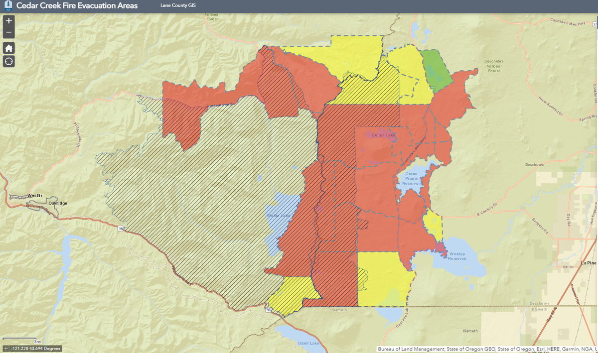
Here's Deschutes County's Cedar Creek evacuation list - the map for levels in both Lane and Deschutes counties can be viewed at: https://lcgisorg.maps.arcgis.com/apps/webappviewer/index.html?id=fffd5cd4131d40bc885331fe3c905283
You can also find the map and other resources, including the evacuation level definitions, here; https://www.deschutes.org/sheriff/page/emergency-information
Below are the updated evacuation levels for Deschutes County due to the Cedar Creek Fire. For detailed information on evacuation areas go to deschutes.org/emergency.
Level 3 - GO NOW
- Areas east of the Lane County/Deschutes County Line, North of the Klamath County/Deschutes County line, northwest side of Wickiup Reservoir, the area surrounding Crane Prairie Reservoir and south of 6 Lakes Trail and Lava and Little Lava Lakes to include:
- Cultus Lake Lodge and Campground
- Little & Big Cove Boat-In Campground
- West Cultus Boat-In Campground
- Little Cultus
- Cultus Mountain
- Crane Prairie Reservoir
- Brown's Mountain
- Lemish Butte
- Ketchketch Butte
- Johnny Lake
Level 2 - BE SET
- North of the line delineating Township 20S from Township 19S, east of the Lane County/Deschutes County line, south of 6 Lakes Trail, and west of Cascade Lakes Highway to include
- Lucky Butte
- Williamson Mountain
- Winopee, Snowshoe, Senoj, Big Finger, Upper Snowshoe, Long, Puppy, Leech, Goldeneye, and Lucky Lakes
- The northwest side of Davis Lake
Level 1 - BE READY
- The area surrounding Lava and Little Lava Lakes
Deschutes County 911 will be using wireless emergency alerts (WEA) to reach visitors in the evacuation areas that may not be signed up for Deschutes Alerts.
Westfir, Ore.- Sept. 7 The closure order for the Cedar Creek Fire has been expanded due to its rapid fire growth. The fire was caused by a lightning storm and is at 18,143 acres and is 12% contained. Highway 58 is not included in the revised closure.
This closure includes several roads, trails and areas including, but not limited to:
Roads: Forest Road 2417, Forest Road 1934, and Forest Road 19 (Aufderheide Drive) from milepost 20 (just east of Kiahanie Campground) to milepost 35 (south of Roaring River Campground)
Trails: West side of the Jim Weaver Loop (Waldo Lake) from the Shadow Bay boat ramp to Forest Road 4636-514 and Erma Bells located in the Three Sisters Wilderness
Campgrounds: Blair Lake; Irish and Taylor Lake; Islet; North Waldo; Harrison Horse Camp; Skookum Creek; Shadow Bay; Box Canyon; Box Staging Area/Horse Camp; and all surrounding dispersed camping areas
“It is truly a collaborative effort with community leaders and local law enforcement to ensure that community needs are being met and that wildfire threats and operations are clearly understood,” said Middle Fork District Ranger Molly Juillerat. “Our first priority is to protect the health, safety, and well-being of the fire management community and the public we serve.”
Campfires are still prohibited on the entire forest due to high fire danger and ongoing active fires. Review a detailed map, the full text of the closure order, and more information on fire restrictions at https://tinyurl.com/25tfzd8w.
Get the latest information about the #CedarCreekFire and firefighting efforts via InciWeb at https://inciweb.nwcg.gov/incident/8307 and on Facebook at https://www.facebook.com/CedarCreekFire2022.
