Deschutes National Forest greatly widens Cedar Creek Fire closure area due to growth near Waldo, Cultus lakes
(Update: Small new fire stopped near Kelsey Butte)
Sheriff's office also out with evacuation info update, urges signing up for emergency alerts
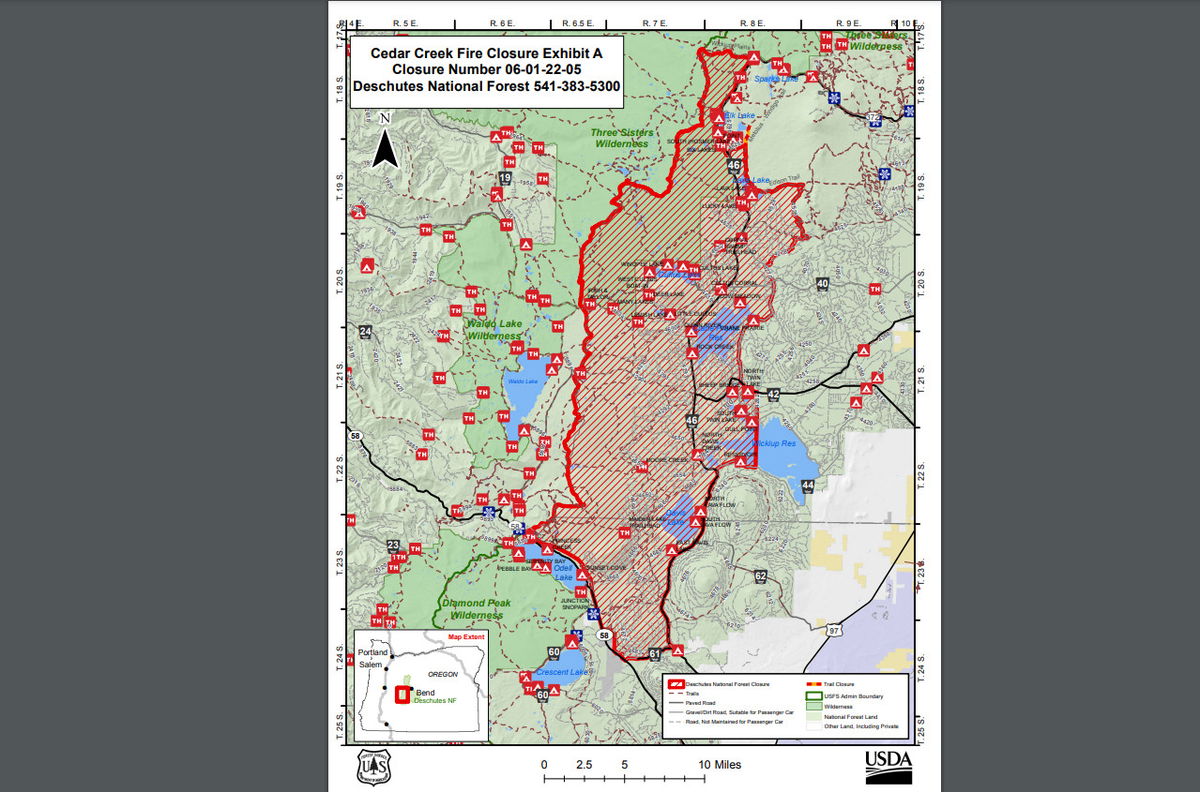
BEND, Ore. (KTVZ) —The Deschutes National Forest said Tuesday it has expanded its forest closure order for the Cedar Creek Fire to create more efficient firefighting operations on the eastern zone of the fire and due to increasing fire growth on the southern tip of Waldo Lake and in the Cultus Lake area.
The expanded closure includes eastern portions of the Three Sisters Wilderness, up to the Cascade Lakes Highway’s western edge, starting south of Hosmer Lake and continuing through the current closure on the Cascades Lake Highway just south of Twin Lakes, Davis Lake, and Wickiup Reservoir. People should go to the Deschutes National Forest’s website (www.fs.usda.gov/main/deschutes/home) to see the closure map and “Know Before You Go.”
New fires continue to emerge and are tackled by firefighters. By Tuesday evening, crews had a line around Incident 914, burning on the Deschutes National Forest about a mile north of Kelsey Butte. They held the fire at 2.4 acres and moved into mop-up activity.
Firefighters have line around Incident #914 burning on the @DesNatlForest approx. 1 mile north of Kelsey Butte. They held the fire at 2.4 acres & are engaged in mop-up. pic.twitter.com/LXhsvwACSS
— Central OR Fire Info (@CentralORFire) September 14, 2022
Though the Cedar Creek Fire is moderating overall, allowing some evacuation levels to drop, firefighters still have a lot of work to do on the eastern edge of the fire to address the still actively growing fire. With the establishment of primary and contingency fire lines, both the Incident Management Team and Deschutes National Forest leadership determined it would increase operational efficiencies including reduced movement of fire equipment and personnel if the forest closure was expanded.
“With the moderation in weather, resources can actively assess and prep road systems and control features before another period of active fire growth due to weather conditions. Efficiency in operations is a key factor for us to consider right now,” said Robert Newey, Fire Management Officer for the Bend-Fort Rock Ranger District of the Deschutes National Forest.
If the public has questions, they may contact the Bend-Ft Rock Ranger District at 541-383-5300.
Cedar Creek Fire Evacuation Update September 13, 2022
Deschutes Co. Sheriff's Office - 09/13/22 6:04 PM
UPDATE September 13, 2022 5:00 PM
Since, September 1, the Deschutes County Sheriff's Office in coordination with the Deschutes National Forest and Fire Managers issued multiple Evacuation Notices due to risk from the Cedar Creek Fire. Currently all areas under evacuation are included inside the updated Emergency Fire Closure Order issued by the Deschutes National Forest on September 13.
For this reason, we are transitioning away from local evacuation notices and encouraging the public to follow the closure area in place to provide for public and firefighter safety. Persons who enter the area may inadvertently place themselves at risk from firefighting operations and may not be aware of changing fire conditions that may threaten the area. Any private lands within this boundary should be considered equivalent to a Level 3: Go Now evacuation.
If conditions worsen, the Deschutes County Sheriff's Office may issue additional evacuation notices outside the forest closure. Please go to www.deschutes.org/emergency for up to date evacuation maps in Deschutes County, as well as the forest closure boundaries. You can also go to the Deschutes National Forest website at www.fs.usda.gov/main/deschutes/home for more information about the Emergency Fire Closure.
Please make sure you are signed up for emergency alerts. You can sign up for emergency alerts in the county you reside or work at www.oralert.gov.
In some cases, local officials may issue Wireless Emergency Alerts, which were issued by both Deschutes and Lane counties during the Cedar Creek Fire due to the large backcountry area affected.
These alerts should alert most cellular phones located within the reach of the alerting towers whether the recipient is signed up for alerts or not. In some cases, these alerts go outside the area at risk, so it is important to pay close attention to the message to determine if you are in the affected area.
Signing up and maintaining a profile with your local alerting authority, which can be done at www.oralert.gov allows you to receive specific messages for your address.
