Gov. Brown seeks federal emergency declaration for Oregon wildfires; more than 1,800 fighting Cedar Creek Fire
Says Oregon would be first state to get such a declaration for wildfire response
SALEM, Ore. (KTVZ) -- As the Cedar Creek firefighting ranks swelled past 1,800, Gov. Kate Brown said Wednesday she's asked President Biden to issue a federal emergency declaration for the state due to extreme risk of significant wildfires, with several burning around the state.
Here is her statement about the request, made under the Robert T. Stafford Disaster Relief and Emergency Assistance Act:
“Last week, as Oregon faced forecasted high winds, sustained hot and dry conditions, and the potential for lightning — and with 168,000 acres burning across the state at the time — Oregonians braced for increased and worsening fires. State firefighting teams and agencies, along with local partners and resources brought in from California and Washington through the Emergency Management Assistance Compact, mobilized to prepare for a swift response and to protect lives, communities, and our natural resources.
“Thanks to science and data, we know enough in the days ahead of anticipated weather and fire patterns — just like states that prepare for hurricanes — that it is imperative to communicate with the public, pre-position resources for our fire response, and employ preventive measures, such as public safety power shut-offs. All of these efforts reflect a modernized approach to meeting the needs of fighting the fires of this century; they are proactive measures that we can take to protect communities and save lives.
“The request I made for a federal disaster declaration is critical to helping bolster our state’s response, and it presents an opportunity for Oregon to partner with the Federal Emergency Management Agency (FEMA) to bridge the gaps we know exist as we work hard to protect our communities. We still have several weeks of peak fire season ahead of us, five large active fires, and 274,000 acres burning statewide. If granted, Oregon would be the first state ever to receive such a declaration for wildfire response — but unfortunately, certainly not the last to need this important assistance.
“I am incredibly grateful for the strong partnership we have with the Biden-Harris administration and with FEMA, with whom we have worked over the past several years on various emergencies. I urge their earnest consideration of my request so that, together, we can protect Oregonians and our communities, and serve as a model of federal support for states facing the ongoing threat of wildfires.”
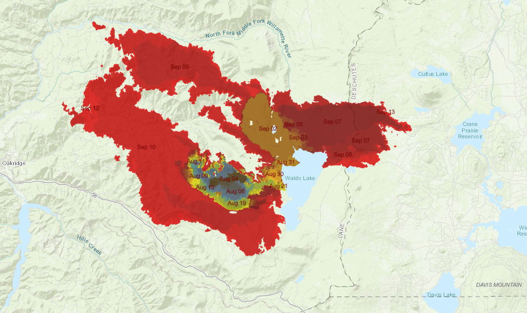
As of Wednesday morning, 1,824 firefighters were battling the Cedar Creek Fire, which has dramatically slowed its growth, from the weekend, reported at 92,525 acres. The more than 6-week-old fire was rolled back to zero containment when hot, dry and windy weather pushed it past containment lines.
Here's Wednesday morning's update on the fire:
Cedar Creek Fire
September 14, 2022
Daily Update – 8:50 AM
Cedar Creek Fire Quick Facts
Size: 92,595 acres
Contained: 0%
Start Date: August 1, 2022
Origin: 15 miles east of Oakridge, Oregon
Cause: Lightning
Total personnel: 1,824
Resources: 93 engines, 28 crews, 87 heavy equipment, 11 helicopters
A fire progression animated map can be viewed at: https://nifc.maps.arcgis.com/apps/instant/slider/index.html?appid=43cb3c38e2a941c38349a29125fc6c8d
Current Situation: The Lane County Sheriff’s Office, in consultation with the fire team, reduced the evacuation to Level 1 (Be Ready) for the City of Westfir and Oakridge between Laurel Butte and the Middle Fork Willamette River west of Fish Hatchery Road. Other areas that were reduced to Level 2 (Be Set) on Monday remain at Level 2, including: High Prairie area, Hills Creek Reservoir area, and Oakridge north of Laurel Butte Road and east of Fish Hatchery Road. The Deschutes National Forest issued an expanded closure Tuesday to include areas of the forest where fire crews are working. Crews are operating heavy equipment along the Cascade Lakes Highway corridor and along forest roads. Residents are asked to be aware of increased fire-related traffic, drive safely, and obey all road closures and traffic safety laws.
The fire remains active, burning with low to moderate intensity. Although fire behavior has calmed considerably since last weekend, fuels are still dry and combustible. Smoke will continue to linger through the week, impacting air quality. Smoke is primarily impacting communities on the east side of the fire, particularly La Pine, Crescent Lake, Sun River, and Bend.
West Zone Operations: The west zone continues to focus on the protecting the communities of Oakridge and Westfir and the Highway 58 corridor. Crews took advantage of fire behavior that was moderated by higher humidity throughout the day. Firefighters continued improving Forest Road 19 as well as other road systems to use as containment lines.
To the west of the fire, firefighters identified ridgetops where they will conduct firing operations to bring the fire toward containment lines. These firing operations will reduce vegetation between the front of the fire and the fireline, thereby moderating burn intensity and improving the effectiveness of the containment lines. In addition, crews conducted strategic firing operations near Eagle Butte.
On the southern edge, the fire continued to back down slopes from Bunchgrass Ridge toward the rail line. A hotshot crew connected handline along the southern boundary west of Fuji Mountain and implemented firing operations along that fireline to reduce ground vegetation in advance of the main fire.
Structural crews continued to perform tactical patrols near Odell Lake; Wednesday they will support burn operations near Highway 58 to remove fuels between the fire’s edge and the highway. Low visibility limited the ability to use helicopters and airplanes for most of the day. Structural firefighters continued their work in the High Prairie area. The night shift worked to support burn operations when conditions were favorable, and Wednesday’s shift will focus on supporting mop up work and performing tactical patrols. Today, crews supported by heavy equipment will keep thinning and chipping vegetation to improve roads for use as containment lines.
Work along the roads includes removing snags that may pose a threat to firefighters. As conditions allow, firefighters will use aerial and hand ignition to improve effectiveness of containment lines. Firefighters are reducing vegetation and improving roads between containment lines and the active fire to be used as a way to slow the fire and reduce intensity as it approaches the control features.
East Zone Operations: Junction camp was established Tuesday near the intersection of Oregon State Routes 429 and 58. This camp positions 210 firefighters closer to their work in the Odell Lake area. Two Type 2 crews and hot shots are assessing and protecting structures around Odell Lake, including Golden Lake Campground, Willamette Pass, and the Diamond Peak area. Protection measures include clearing brush from around structures and laying hose and sprinklers. Road prep was started and will continue over the next few days on Forest Road 5897 from State Route 58 to Fuji Mountain Trail. Hand crews are also working to join Forest Roads 4660 and 4668. Hand crews have also been working Forest Road 700 near Brown Mountain, south of Crane Prairie Reservoir. Heavy equipment continues along the Cascade Lakes Highway, creating a 100-foot fire break on the west side of the road. To the north, structure protection continues around Lava Lake.
Weather/Fire Behavior: Weather conditions are expected to stay moderate with light west winds and cooler seasonal temperatures in the 60s. Fuel moisture levels are at a point where grasses are not easily carrying fire but larger sticks and limbs that are about wrist sized are actively burning. The southern edge of the fire is expected to continue backing down toward containment lines and may reach the Eagle Creek area in the next day or two. Some torching and spotting are expected, but most activity should be creeping and smoldering.
Evacuations: An updated map of the evacuation areas is available at www.LaneCountyOR.gov/CedarCreek. It is possible that conditions may require moving back to a Level 2 (Be Set) or a Level 3 (GO NOW) evacuation notice in some or all of these areas, depending on fire activity. Sign-up for emergency mobile alerts by going to oralert.gov. Please check with Lane County Sheriff’s Office at 541-682-4150 and Deschutes County Sheriff’s Office at 541-693-6911 for updates and changes. Go to https://bit.ly/3D51kvC to view a map. Lane County people can use the Lane County Sheriff’s Office Flash Alert site for information to support claims for reimbursement for lodging https://flashalert.net/id/LaneSheriff.
Closures: The Deschutes National Forest expanded the temporary emergency closure area to protect the public and firefighters. The Deschutes National Forest and Willamette National Forest both have closures in effect. Please visit Willamette National Forest and Deschutes National Forest for the most recent closure orders and map. A Temporary Flight Restriction (TFR) is in place. The use of drones is prohibited in the fire area, please make it safe for our firefighters to use aircraft on the fire. Pacific Crest Trail hikers should visit pcta.org for current information.
Restrictions: Fire restrictions are in place on the Willamette National Forest and Deschutes National Forest.
Smoke: For current conditions, see Fire.airnow.gov, oakridgeair.org, and LRAPA - Today's Current Air Quality. Smoke Forecast Outlooks are available at https://outlooks.wildlandfiresmoke.net/outlook.
Online: https://inciweb.nwcg.gov/incident/8307/ | https://www.facebook.com/CedarCreekFire2022/ |
YouTube: https://www.tinyurl.com/cedarcreekfireyoutube
Fire Information: 8:00 AM – 8:00 PM | Phone: 541-201-2335, Media Line: 541-327-9925 |
Email: 2022.cedarcreek@firenet.gov
