17,000 acres of burnouts along west containment line push Cedar Creek Fire past 112K acres
(Update: Saturday night acreage, personnel figures)
OAKRIDGE, Ore. (KTVZ) -- Firefighters' conducting firing (burnout) operations along the primary west-side containment line in recent days have pushed the Cedar Creek Fire's size to more than 112,000 acres, officials said Saturday.
An update late Saturday night put the fire's size at 112,287 acres and the firefighting force at 2,498 personnel.
The cost to fight it so far is about $65 million, officials said in Saturday's National Interagency Fire Center situation report.
Here's the Saturday morning update and area map:
Cedar Creek Fire
September 17, 2022
Daily Update at 8:45 AM
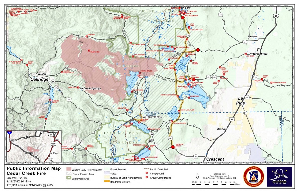
Cedar Creek Fire Quick Facts
Size: 110,361 acres
Contained: 0%
Start Date: August 1, 2022
Origin: 15 miles east of Oakridge, Oregon
Cause: Lightning
Total personnel: 2,375
Resources: 84 engines, 51 crews, 111 heavy equipment, 12 helicopters
Current Situation: The increased acreage is due to firing operations that have been implemented along the primary containment line on the west side of the fire over the past few days. As fuel moisture and weather permit, more aerial ignition will occur to slowly bring the main fire toward the completed burnout. In the East Zone, light westerly winds will influence fire spread to the east and potentially consume unburned fuels.
Areas east and southeast of the Cedar Creek Fire will have the greatest smoke impacts, including: La Pine, Crescent Lake, and Silver Lake. Oakridge should have moderate to good air quality through the day, as will other areas to the west and southwest. The weather pattern moving in over the weekend should dampen smoke impacts.
Oakridge Community Meeting: A community meeting was scheduled for 11 am Saturday at the Oakridge High School Auditorium. The intent was to also stream the meeting on Facebook Live for those who cannot attend in person (www.facebook.com/events/462741735787657 ).
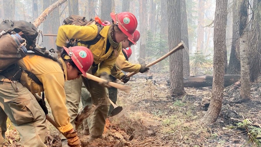
West Zone Update: On the west zone, the fire has been backing downhill and torching where there are accumulations of dead and down trees. On the north side of the fire, crews and equipment continue preparing the 19 road for firing operations to keep the fire south of that road. To the west, firefighters took advantage of favorable conditions to continue with aerial ignition, working the fire toward the primary containment line. This was a coordinated effort as firefighting resources, including hand crews, water tenders, skidders, engines, and air resources were all actively engaged in accomplishing the mission. Firefighters will mop-up and patrol along the completed burnout. To the south, the fire is backing from Bunchgrass Ridge toward containment lines. The night shift patrolled primary containment lines and mopped up where needed to keep the fireline secure. Given the steep terrain, heavy component of dead and down vegetation, and continuous tree canopy, this strategy has the highest probability of success for meeting the primary objectives of protecting the communities of Oakridge, Westfir and High Prairie, as well as Highway 58 and Union Pacific Railway, while limiting firefighter exposure to risks like tree strikes. The strategy takes time to implement, as windows of opportunity for achieving successful firing operations can be short.
East Zone Operations: The Wolf Creek Hotshots and Mormon Lake Hotshots are going direct on the fireline east of Charlton Lake, where the fire crossed FS Road 4290. They are strengthening the FS 4290 as a holding line to prevent future potential spread of the fire to the south. Another barrier is being created by tying FS 5897 to the FS 4290 road to the north and to the Fuji Mountain trail and State Route 58 to the south. Another fuel break between Odell Lake and Davis Lake is being strengthened on the west side of FS 4668 to meet 4660. Similarly, road work is continuing on FS 700 to connect with FS 4630 that will tie together Crane Prairie Reservoir and Little Cultus Lake. Chipping operations are underway along FS 640 between Little Cultus Lake and Deer Lake. Work continues along the west side of the Cascade Lakes Highway to create a shaded fuel break. Masticators are working along State Route 58 north of Odell Lake.
Weather: The weekend will bring a low-pressure system dropping south along the coast with a chance of rain Saturday night and into Sunday. There are a variety of conditions over the fire area, due to cloud cover and aspect. Rain is predicted for Saturday, however projections vary as to the amount of rain in different areas of the fire. Some scattered thunderstorms may develop in the East Zone.
Evacuations: An updated map of the evacuation areas is available at www.LaneCountyOR.gov/CedarCreek. It is possible that conditions may require moving back to a Level 2 (Be Set) or a Level 3 (GO NOW) evacuation notice in some or all of these areas, depending on fire activity. Sign-up for emergency mobile alerts by going to oralert.gov. Please check with Lane County Sheriff’s Office at 541-682-4150 and Deschutes County Sheriff’s Office at 541-693-6911 for updates and changes. Go to https://bit.ly/3D51kvC to view a map. Lane County people can use the Lane County Sheriff’s Office Flash Alert site for information to support insurance claims for reimbursement for lodging https://flashalert.net/id/LaneSheriff.
Closures: Elijah Bristow State Park and Dexter Boat Launch are closed to the public, since they are being used by firefighters. The Deschutes National Forest and Willamette National Forest both have closures in effect to protect the public and firefighters. Please visit Willamette National Forest and Deschutes National Forest for the most recent closure orders and maps. A Temporary Flight Restriction (TFR) is in place. The use of drones is prohibited in the fire area, please make it safe for our firefighters to use aircraft on the fire. Pacific Crest Trail hikers should visit pcta.org for current information. See a map of the fire area with both forest closures here: https://inciweb.nwcg.gov/incident/map/8307/0/137083
Restrictions: Fire restrictions are in place on the Willamette National Forest and Deschutes National Forest.
Smoke: For current conditions, see Fire.airnow.gov, oakridgeair.org, and LRAPA - Today's Current Air Quality. Smoke Forecast Outlooks are available at https://outlooks.wildlandfiresmoke.net/outlook.
Online: https://inciweb.nwcg.gov/incident/8307/ | https://www.facebook.com/CedarCreekFire2022/ |
YouTube: https://www.tinyurl.com/cedarcreekfireyoutube
Fire Information Line: 541-201-2335, 8:00 AM – 8:00 PM |
Email: 2022.cedarcreek@firenet.gov
