Containment figure climbs to 32% on 2-month-old Cedar Creek Fire
OAKRIDGE, Ore. (KTVZ) -- This week's early-fall warmup may prompt more activity on the 2-month-old Cedar Creek Fire, but officials said Monday they have reached nearly one-third containment of the lightning-sparked blaze.
Here's Monday's fire update:
Cedar Creek Fire
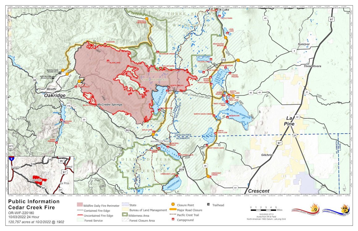
October 3, 2022 | Update 8:30 AM | Size: 120,575 acres | Contained: 32% | Start Date: August 1,2022 | Origin: 15 miles east of Oakridge, OR
Cause: Lightning | Total personnel: 896 | Resources: 17 engines; 14 crews; 17 heavy equipment; 7 helicopters
A Burned Area Emergency Response (BAER) team has arrived to the Cedar Creek Fire to assess post-fire rehabilitation and recovery. The BAER team will be working across both zones of the fire. Northwest Incident Management Team 9 is assuming command of the Potter and Big Swamp Fires today.
West Zone Operations: Weather conditions and fire behavior yesterday allowed for strategic firing operations in Division X on the western edge of the fire. These firing operations included the use of a plastic sphere dispenser (PSD) that drops “ping pong” balls injected with flammable materials from the helicopter. These spheres ignite upon impact with the ground to consume unburned fuels between the main body of the fire and established containment lines. Low intensity burning from these operations will help decrease the duration of smoke impacts in the area. Firefighters are working to secure Forest Service Road 2409 to safely access the interior of the north, northwest region of the fire. The south and southwest region of the fire will be undergoing additional clean up along the fire edge with possible firing operations dependent on conditions. Finalized repairs are being conducted on the north edge of the fire along the sides of Forest Service Roads 1958 and 19.
East Zone Operations: Work on the East side of the Cascade Crest yesterday included improvements and repair of indirect containment line, road work, removal of structure protection materials and looking ahead to continue reducing impacts to the area. Today, work along Forest Service Road 46 continues as equipment and crews come closer to completing work on the indirect containment line. In addition to roadside repair, rocking and grading along Forest Service Road 700 near Cultus Lake will progress, as well as berm removal and clearing of culverts that were affected during operations. Temperatures have remained consistently warmer, as predicted, which has resulted in minimal amounts of moisture retention from the precipitation that fell over the fire last week. Fire behavior is expected to continue creeping and smoldering, with a small possibility of torching due to drier fuels.
Weather: Continued southeast winds in the morning and northwest winds in the evening will shift smoke away from Oakridge and surrounding communities in the afternoon. Temperatures will remain in the high 70s and 80s for the coming week.
Closures: The Deschutes National Forest and Willamette National Forest both have closures and fire restrictions in effect. Some of these closures will remain in effect until areas that have been heavily impacted by the fire are surveyed for safety hazards. Please respect Forest closures for firefighter and public safety. Violations of these prohibitions are punishable by a fine of not more than $5,000.00 for an individual or $10,000.00 for a corporation or imprisonment for not more than six months or both. 16 USC § 551 and 18 U.S.C §§ 3551, 3559, 3571, and 3581. Please visit Willamette National Forest and Deschutes National Forest for the most recent closure orders and maps. A Temporary Flight Restriction (TFR) is in place. The use of drones is prohibited in the fire area, please make it safe for our firefighters to use aircraft on the fire. Pacific Crest Trail hikers should visit pcta.org for current information.
Smoke: For current conditions, see Fire.airnow.gov, oakridgeair.org, and LRAPA - Today's Current Air Quality. Smoke Forecast Outlooks are available at https://outlooks.wildlandfiresmoke.net/outlook.
Evacuations: An updated map of the evacuation areas is available at www.LaneCountyOR.gov/CedarCreek. Sign-up for emergency mobile alerts by going to oralert.gov. Please check with Lane County Sheriff’s Office at 541-682-4150 and Deschutes County Sheriff’s Office at 541-693-6911 for updates and changes.
